Quote
DavidK42
Quote
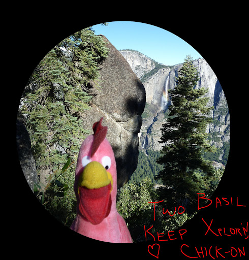
chick-on
It is my understanding that Rainbow View is Oh My Gosh! Pt.
Unfortunately I cannot at the moment find the map with OMG on it.
Everyone is now calling the Lower Yose view point OMG now it seems.
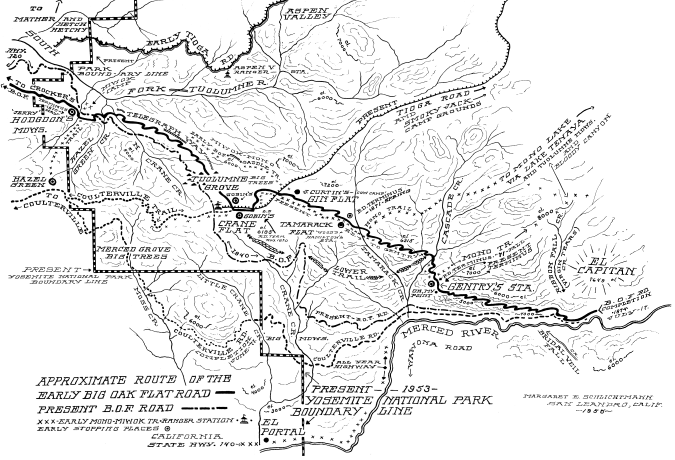
I know what you mean about the Lower Yose overlook. On the older maps, though, it's clearly nowhere there. Here's the map I was carrying with me on last week's hike (from the Paden/Schlichtmann book).
(If interested, there's a much larger copy of the picture
here.) You can see that Oh My! is just about where the road gets out to the edge of the cliff (immediately beyond Gentry's) and you can see the Valley (well, more the Merced Canyon beyond the Valley but still worthy of an "Oh My!"

)
OK, here is more than you wanted to know about these things. I stumbled upon my copy of "the Big Oak Flat Road to Yosemite" by Margaret Schlichtmann (1959) today. It is a marvelous book, with many fascinating photographs. Unfortunately, my copy is a wretched 1975 paperback version which really botched the photos. It starts with a photo of the dead trunk of the Big Oak at Big Oak Flat (1870), which is certainly the largest oak that I have ever seen. This book has chapter about the section of road that we are discussing, which clears up a lot of things. Especially when combined with the overlay map "Historical Base Map of Yosemite valley".
http://www.yosemite.ca.us/library/yosemite_resources/images/historical_base_map_yosemite_valley.jpg
I wish I had a copy of the map that this is an overlay for. On this overlay, [1] is the Old Big Oak Flat Road. But it didn't exist until 1872. For a decade or more before that there was a pack trail [20] leading from Crane Flat down to the the Valley. As the BOF was being built, people would travel the stage road to its terminus, then by horse and mule to Gentry's Hotel, (6) on the map, which grew into a major enterprise. At this point, they would transfer to the mule outfit that went down the pack trail [20] to the valley. Note that it descended steeply down to the valley at a point before the great switchback. Chick-On talks about having done some bushwhacking in the area recently, I think. Anyway, the mule track did not cross the huge talus piles where the Zigzag would be, which makes sense to me.
(31) on this map is the pipe rail labelled on the overlay "Rainbow View or Oh My! Point". But Ms. Schlichtmann has a different story about that. See below.
Gentry's became a sawmill and later a park entrance station after the road was finished. During the period before the road was completed, the place was busy and prosperous with supply mule trains and passenger groups stopping. The book says this about it: "
The last station on the road was Gentry's, down the mountain from Tamarack Flat at an elevation of 5627 feet." That's exactly where the entry station is located on the topo map in an earlier post of this thread. It is not where the overlay map shows both the hotel and sawmill and livery station being at (6). Those are located at the flat place where the El Cap Trail hits the old road. I have looked around that in that area, and there are certainly a bunch of what could be foundations and stuff at (6). My guess is that the original hotel might have been where the entry station was later located, but the other stuff was built in the larger flat area at (6). That's why the El Cap foot trail goes there. To continue:
"It was on the brink of the tremendous cliffs overhanging the canyon of the Merced just below Yosemite Valley but was so hemmed in by timber that the precipice was invisible." At least it was until the sawmill was built there.
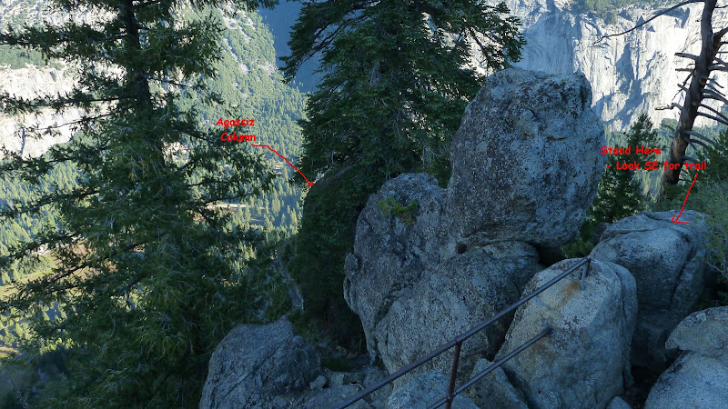
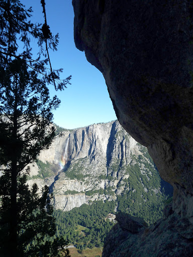
"Within a few yards of Gentry's a first breath-taking view from the cliff was entitled 'Prospect Point' but when the general public began to travel this way and to express their surprise the early stage drivers soon dubbed it 'Oh My! Point'. From it the descending parade could see the final miles of the Coulterville Road..." Ok, that's not Rainbow View. It must be about where I took some photos earlier. See the third and fourth photos in this post:
http://yosemitenews.info/forum/read.php?3,29227,29227#msg-29227Of course,Oh My! Point is wherever the current stage coach driver tells you that it is.
By the way, the author is very clear that the great switchback is to be called "the Zigzag". I stand corrected.
"After the Zigzag became a control road the checking station was at Gentry's. There was a similar station on the valley floor. Down traffic was allowed to proceed at stated hours. Up traffic checked out of the valley in the intervals. For forty years, from 1874 to 1917, only horse-drawn vehicles traveled this stretch and two miles an hour was a fair average speed. Nor, especially on the up grade, was there much once could do about hurrying it."In the overlay map above, there is a small bridge shown near the upper left corner. This is not the bridge over the upper branch of Cascade Creek. The overlay doesn't go quite far enough to show that one. It is a bridge over the next branch, where the Lower Trail comes in from the west. Both are shown on the topo map higher in this thread. Unfortunately, Chick-On did not post the next piece of map to the northwest, which would show the following bit of interesting bushwhacking to be done between Tamarack and Cascade creeks:
"A generous two-tenths of a mile past the present bridge over Tamarack Creek [traveling west from the saloon at Tamarack Flat]
brings one to a well-marked gully leading up on the left. Along this small gulch went the Mono Trail joining Tamarack Flat with Yosemite Creek... ...It was exceedingly rough and steep even after being cleared out and blazed in 1857, but had the advantage of water and shade. Now it is impassable. [This was written in 1959.]
Other portions of the Mono Trail have been maintained by the government for modern hikers, but this branch has been forgotten and is recognizable only by the blaze marks about six feet up on the large trees. Many of them have fallen and disintegrated but such marks as are left are always to be found on the right of the trail no matter in which direction one is traveling. [Meaning that they didn't blaze both sides of the same tree.]
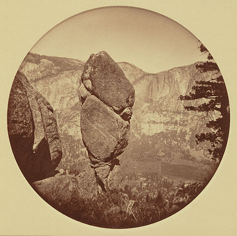
About a mile up the hill the trail goes through "Split Rock" which looks as if it had been divided for the purpose." Some interesting bushwhacking to be done there. Do any of the blazes still exist fifty years after the book was written? I have found some very interesting rock formations in that area, but don't recognize that one.... The overlay shows only the "Gentry Branch of the Mono Trail" [22], which is part of the El cap Trail in this area and not the neglected branch mention here.
Another bit of possible bushwhacking has to do with the early bridge over Cascade Creek. It may have been below the junction of the two tributaries shown on the topo map above.
"The telegraph line to Yosemite followed the road and at this point both plunged down through small, precise silvery fir trees to cross Cascade Creek. A keen observer may be lucky enough to spy one of the rare dull green insulators still fastened high on a tree." [1959] Of course, the telegraph would have been abandoned as soon as the railroad came up the Merced River to El Portal and a dirt road (140) went into the park from there. Are there any of those insulators still left? There was recently a convention of telegraph and telephone insulator collectors here in San Jose. They hunt for those things, so there may be none left. But this would involve serious bushwhacking, so maybe there are still some there.
What a shame that I'm stuck back East for another month or so. Chick-On might beat me to it. And scrawny birds are better than I am for looking at things in trees. Maybe the marmots will get him first.
About the "Lower Trail" It's in the book, too. It was a pack trail, the latter half of which followed the foot trail north east of Foresta that exists today to connect the new highway to the El Cap Trail . It was used in Spring and Fall because the upper trail took too long to melt free of snow. On the overlay, brackets mean trails or roads and parentheses mean points of interest. [21] is the Coulterville Trail (not Coulterville Road) which also went to Gentry's. [22] is the Gentry branch of the Mono Trail, which then splits off to the north. At that split [23] continues on to El Capitan and Eagle Peak. (28) is the "Standpoint of Silence", which I think is on the ridge overlooking Foresta. I wish I had the map that goes with the overlay....
Edited 1 time(s). Last edit at 09/29/2011 11:30AM by wherever.


 (from
(from 


 )
)