Welcome! Log In Create A New Profile Recent Posts
Yosemite Valley

The Moon is Waxing Gibbous (58% of Full)

JanSport


Advanced

Re: Moran Point and the Old Four Mile Trail (was Re: Old Big Oak Flat Road question)

All posts are those of the individual authors and the owner of this site does not endorse them. Content should be considered opinion and not fact until verified independently.

Old Big Oak Flat Road question
September 15, 2011 01:39PM
On our last visit to the Park, my wife & I hiked from Tamarack Flat down to Rainbow View and back. Shortly before the road hits the beginning of it's down-slope and you first get a glimpse of the Valley (I think is the spot which is labelled "Oh My! Point" on some old maps...about 3/4 or a mile west of Rainbow View), the road widens considerably. If you've been on this section of the road, it's also noticeable for their being three obviously old trees side by side...one on either side of the road and one dead-center with enough room for stages and/or old cars to go around either side of the middle tree. In the early days of Yosemite travel, there was a small hostelry named Gentry's in this area. I also recall reading that there was a "vehicle checking station" at this point in the early days of car travel (at that point (I think in the stage days as well), travel down this stretch of the road was one-way (up on the hours, down on the half-hours (or vice-versa)...or maybe it alternated on the hours instead of the half-hours) and the checking stations helped control this). I'm sure I've got this information in old books somewhere, possibly with some period pictures but I haven't had a chance to look it up since I've gotten back home.

Is there anyone here who's familiar with the section to which I'm referring and can comment on the Gentry's/Checking Station association?

I'm also curious about Oh My! Point...I may have it on some old USGS maps but the only one on which I've found it since getting back is an old hand-drawn map which is quite approximate. Anybody know a definitive location for OMP?

And before people ask, yes, I will post a trip report with pictures soon but I have the sort of job that when you take almost two weeks off, there's a LOT of catch-up work to do when you get back so it may take me a bit! eye popping smiley
Re: Old Big Oak Flat Road question
September 15, 2011 02:53PM
There are many threads about the Old Big Oak Flat Road on this forum. And there are even several books that have been published about the thing.

The old entrance station is clearly shown on map 45 of the Chick-On Map Gallery:
http://picasaweb.google.com/103089501068510688008/YoseMaps?gsessionid=gbHhLhE7TuWIpfIKvmOmGA#5560700011896075282


His 1933 road map shows the Gentry ranger station in about the same spot. see map 126


However, the original Gentry Station was a stage coach team-swapping stables dating back to when the road was first built. It may have been back up the road a short distance from the dot on the map, in order to have more space for buildings and an all-year stream to water the stock.. Perhaps closer to where the trail from El Cap came in at that time. So it depends on which Gentry Station you are talking about.
Re: Old Big Oak Flat Road question
September 15, 2011 06:58PM
Quote
wherever
There are many threads about the Old Big Oak Flat Road on this forum.
Yup...I've read most of them...just hadn't seen specific reference to Gentry's in them.


Quote
wherever
And there are even several books that have been published about the thing.
I have the Irene D. Paden and Margaret E. Schlichtmann book and there are certain discussion (sometimes extensive) in other books (especially the Yosemite Yesterdays books and the Yosemite Grant hardcover book) but the Paden/Schlictmann's the only one I know that's exclusively about the road. Are there others you're aware of?

Quote
wherever
The old entrance station is clearly shown on map 45 of the Chick-On Map Gallery:
Without pulling out my GPS and double-checking co-ordinates, that appears to be exactly the spot to which I'm referring.

Quote
wherever
However, the original Gentry Station was a stage coach team-swapping stables dating back to when the road was first built.
Actually, before that, it offered crude accommodations for travelers significantly before the road was built (back when you had to take a horse (or walk)) the final several miles in to the Valley.

Quote
wherever
It may have been back up the road a short distance from the dot on the map, in order to have more space for buildings and an all-year stream to water the stock.. Perhaps closer to where the trail from El Cap came in at that time.
I'd have to pull out some of my old maps to determine where the El Cap trail came in at that point but the spot I'm referring to was definitely big enough for the size of building we're talking about (there's a relatively large flat area to the north of the road at that point). Good point about the water, though. Still, Paden/Schlichtmann describes the original Gentry's as being "The last station on the road...down the mountain from Tamarack Flat at an elevation of 5627 feet. It was on the brink of the tremendous cliffs overhanging the canyon of the Merced just below Yosemite Valley but was so hemmed in by timber that the precipice was invisible." Looking back at the USGS section of map you posted above, that would seem to place it pretty darn close to the Checking Station (and, if anything, further DOWN the road rather than up the road (although, once past that point, there's no place for stages to even pass one another, much less put a building).

Quote
wherever
So it depends on which Gentry Station you are talking about.
Definitely referring to the early "stopping place" that dates back to the days when this section of the "road" was still just a horse trail.
avatar Re: Old Big Oak Flat Road question
September 15, 2011 03:29PM
It is my understanding that Rainbow View is Oh My Gosh! Pt.
Unfortunately I cannot at the moment find the map with OMG on it.

Everyone is now calling the Lower Yose view point OMG now it seems.


Chick-on is looking at you!
Re: Old Big Oak Flat Road question
September 15, 2011 07:06PM
Quote
chick-on
It is my understanding that Rainbow View is Oh My Gosh! Pt.
Unfortunately I cannot at the moment find the map with OMG on it.

Everyone is now calling the Lower Yose view point OMG now it seems.

I know what you mean about the Lower Yose overlook. On the older maps, though, it's clearly nowhere there. Here's the map I was carrying with me on last week's hike (from the Paden/Schlichtmann book).
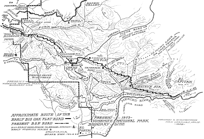


(If interested, there's a much larger copy of the picture here.) You can see that Oh My! is just about where the road gets out to the edge of the cliff (immediately beyond Gentry's) and you can see the Valley (well, more the Merced Canyon beyond the Valley but still worthy of an "Oh My!" winking smiley )


Edited 1 time(s). Last edit at 09/15/2011 07:07PM by DavidK42.
avatar Re: Old Big Oak Flat Road question
September 15, 2011 08:48PM
Yeah, that's the map! OK, definitely not Rainbow View... oops
Maybe it is BM 5729 on the USGS map?
Didn't go that far last February.
I know you've looked at these before... but here they are again:
https://picasaweb.google.com/yosemite.chick.on/Rockslides
(the USGS map is there with the BM)

The Oh My! is far inferior to Rainbow View. Even going all he way down to the
cliff edge it still is not as nice as Rainbow View.
(my comment regarding Oh My! w/r to Yosemite Falls was that someone seems
to have hijacked the name and it has spread)
(I was quite surprised to see it on the old map you linked to)

Anyway, glad you had a great trip and were able to hike on some of the old roads.
I know you have a passion for it.

Any chance you went searching for the Old Yosemite Grant sign?


Chick-on is looking at you!
Re: Old Big Oak Flat Road question
September 16, 2011 08:59AM
Quote
chick-on
Any chance you went searching for the Old Yosemite Grant sign?

Interesting, what do you mean by sign? Is it just the benchmark/boundary marker of the old grant or is there a sign/plaque or something of that nature there?
avatar Re: Old Big Oak Flat Road question
September 16, 2011 09:03AM
Quote
buster
Quote
chick-on
Any chance you went searching for the Old Yosemite Grant sign?

Interesting, what do you mean by sign? Is it just the benchmark/boundary marker of the old grant or is there a sign/plaque or something of that nature there?

Boundary marker.
avatar Re: Old Big Oak Flat Road question
September 19, 2011 06:56PM
Quote
buster
Quote
chick-on
Any chance you went searching for the Old Yosemite Grant sign?

Interesting, what do you mean by sign? Is it just the benchmark/boundary marker of the old grant or is there a sign/plaque or something of that nature there?
There's a couple of signs on the trees and a boundary marker. No plaque per se.
Pictures here (click forward):
https://picasaweb.google.com/yosemite.chick.on/BenchMarkers?authkey=Gv1sRgCMfQ4IvD8NO9SQ#5649847651544196130

Thanks to YosemiteSteve for his NPS video of this on Maps.


Chick-on is looking at you!
Re: Old Big Oak Flat Road question
September 26, 2011 04:17PM
Quote
chick-on
Quote
buster
Quote
chick-on
Any chance you went searching for the Old Yosemite Grant sign?

Interesting, what do you mean by sign? Is it just the benchmark/boundary marker of the old grant or is there a sign/plaque or something of that nature there?
There's a couple of signs on the trees and a boundary marker. No plaque per se.
Pictures here (click forward):
https://picasaweb.google.com/yosemite.chick.on/BenchMarkers?authkey=Gv1sRgCMfQ4IvD8NO9SQ#5649847651544196130

Thanks to YosemiteSteve for his NPS video of this on Maps.

Cool. So the marker with the right angle bend on it would be at this spot, where the old grant line took a bend?
http://mapper.acme.com/?ll=37.73454,-119.70210&z=15&t=T&marker0=37.73147%2C-119.62890%2C1.0%20km%20ExSE%20of%20El%20Capitan%20CA&marker1=37.73454%2C-119.70210%2C1.4%20km%20N%20of%20Yosemite%20Valley%20CA
(Give the map a minute to fill in from the web.) And the bench mark on this map at 5729 is the exact location of the old entry station? My GPS can find that place easily enough.
Re: Old Big Oak Flat Road question
September 16, 2011 12:02PM
Quote
chick-on
The Oh My! is far inferior to Rainbow View. Even going all he way down to the
cliff edge it still is not as nice as Rainbow View.
Completely agree with that...although it is pretty dramatic when you first come out of several miles of travelling through the woods (also some particularly beautiful spots as the old road more or less parallels Cascade Creek south (and east) of the bridge. I can't recall if I've ever seen pictures of the original bridge across Cascade Creek. Pretty sure the current one post-dates usage of the road as a road (the pavement is still pretty intact on both sides but the current bridge, aside from not looking very car (or even stage)-worth, is a few feet lower than the road bed).

Quote
chick-on
Any chance you went searching for the Old Yosemite Grant sign?
Oh nuts! That didn't even occur to me when I was out there...I'll just have to go back, I guess! hot smiley
Re: Old Big Oak Flat Road question
September 15, 2011 09:24PM
Quote
DavidK42
Quote
chick-on
It is my understanding that Rainbow View is Oh My Gosh! Pt.
Unfortunately I cannot at the moment find the map with OMG on it.

Everyone is now calling the Lower Yose view point OMG now it seems.

I know what you mean about the Lower Yose overlook. On the older maps, though, it's clearly nowhere there. Here's the map I was carrying with me on last week's hike (from the Paden/Schlichtmann book).

(If interested, there's a much larger copy of the picture here.) You can see that Oh My! is just about where the road gets out to the edge of the cliff (immediately beyond Gentry's) and you can see the Valley (well, more the Merced Canyon beyond the Valley but still worthy of an "Oh My!" winking smiley )

Thanks for the history lesson. According to same site/source, the OM! point was later renamed to Rainbow View. Which time of day would be best for the rainbow?
Re: Old Big Oak Flat Road question
September 16, 2011 12:05AM
Quote
Ohnivy-Drak
Quote
DavidK42
Thanks for the history lesson. According to same site/source, the OM! point was later renamed to Rainbow View. Which time of day would be best for the rainbow?

Well, the original OMG Point may have been near the entry station. Think about it. People had to spend time there, messing around with the horses, and they weren't going to just sit on the stage. Also, the El Cap Trail would have routed to that point, just as the Pohono Trail was originally routed to Fort Monroe, to meet the Old Wawona Road there. It's where the rangers were. It's where you could buy some supplies from the stage crews. So the map is probably accurate in that sense. But after the automobile came and the entry station was moved, Rainbow View was definitely where it is now, at the pipe rail above the great switchback.

To get the rainbow from either place, you want the sun at your back. Mid to late afternoon, depending on the season. At other times you get only a partial rainbow. I think that I posted this photo before. I really can't remember if it was taken at the Rainbow View pipe rail or farther down the trail My best guess is that it was taken from the bottom of the switchback, not the top. Anyway, you can see that the angle of the sun is not quite optimum. It appears that the vantage point here is a bit too low. So the optimum would be higher on the trail and later in the day. But of course, who wants to get to the bottom of this trail in the dark? When it was still a road or a maintained trail, that would have been no problem. Today, a serious photographer would choose a day during the Spring runoff, then hang out at the pipe railing until the right time. Taken May 17, 2003
Re: Old Big Oak Flat Road question
October 09, 2011 07:34PM
Quote
wherever
Quote
Ohnivy-Drak
Quote
DavidK42
Thanks for the history lesson. According to same site/source, the OM! point was later renamed to Rainbow View. Which time of day would be best for the rainbow?

Well, the original OMG Point may have been near the entry station. Think about it. People had to spend time there, messing around with the horses, and they weren't going to just sit on the stage. Also, the El Cap Trail would have routed to that point, just as the Pohono Trail was originally routed to Fort Monroe, to meet the Old Wawona Road there. It's where the rangers were. It's where you could buy some supplies from the stage crews. So the map is probably accurate in that sense. But after the automobile came and the entry station was moved, Rainbow View was definitely where it is now, at the pipe rail above the great switchback.

To get the rainbow from either place, you want the sun at your back. Mid to late afternoon, depending on the season. At other times you get only a partial rainbow. I think that I posted this photo before. I really can't remember if it was taken at the Rainbow View pipe rail or farther down the trail My best guess is that it was taken from the bottom of the switchback, not the top. Anyway, you can see that the angle of the sun is not quite optimum. It appears that the vantage point here is a bit too low. So the optimum would be higher on the trail and later in the day. But of course, who wants to get to the bottom of this trail in the dark? When it was still a road or a maintained trail, that would have been no problem. Today, a serious photographer would choose a day during the Spring runoff, then hang out at the pipe railing until the right time. Taken May 17, 2003


In a book called "Tales and Trails" (paraphrasing), it says the best time to go is late afternoon during either Autumn or Spring. One can start from the base of El Cap, near the V 9 marker, off a dirt road. I'm sure this has been mentioned at some point in this thread. Foresta would be another TH. Not certain about the accuracy of this fact, but book states Rainbow View was later renamed to "New Inspiration Point."


Edited 2 time(s). Last edit at 10/09/2011 07:36PM by Ohnivy-Drak.
Re: Old Big Oak Flat Road question
September 16, 2011 02:38PM
Quote
Ohnivy-Drak


Thanks for the history lesson. According to same site/source, the OM! point was later renamed to Rainbow View. Which time of day would be best for the rainbow?
http://www.photocentric.net/rainbow_angles.htm


Edited 1 time(s). Last edit at 09/16/2011 02:38PM by hotrod4x5.
avatar Re: Old Big Oak Flat Road question
September 15, 2011 10:47PM
Quote
DavidK42

I know what you mean about the Lower Yose overlook. On the older maps, though, it's clearly nowhere there. Here's the map I was carrying with me on last week's hike (from the Paden/Schlichtmann book).


(If interested, there's a much larger copy of the picture here.)

Just wondering, is that "LOWER TRAIL" from Crane Flat to Cascade Creek that's clearly shown on Paden/Schlichtmann' map still there? (The trail travels between Old Big Oak Flat Road and the current Big Oak Flat Road.)

It appears that a small portion of it, between Tamarack Creek and Cascade Creek is still in use as part of the current trail that starts near the junction of Foresta Road and the current Big Oak Flat Road. But what about the portion of the "Lower Trail" between Crane Flat and Tamarack Creek that appears to travel around the vicinity of the Devils Dance Floor? Does remnants of this part of the Lower Trail still exist today?


Edited 2 time(s). Last edit at 09/15/2011 10:49PM by plawrence.
Re: Old Big Oak Flat Road question
September 16, 2011 12:14AM
Quote
plawrence
Just wondering, is that "LOWER TRAIL" from Crane Flat to Cascade Creek that's clearly shown on Paden/Schlichtmann' map still there? (The trail travels between Old Big Oak Flat Road and the current Big Oak Flat Road.)

It appears that a small portion of it, between Tamarack Creek and Cascade Creek is still in use as part of the current trail that starts near the junction of Foresta Road and the current Big Oak Flat Road. But what about the portion of the "Lower Trail" between Crane Flat and Tamarack Creek that appears to travel around the vicinity of the Devils Dance Floor? Does remnants of this part of the Lower Trail still exist today?

OK, I've bushwhacked down that slope to that current trail numerous times, skirting either side of the cliff at the Devils Dance Floor. Yes, the current trail follows the eastern portion of the "Lower Trail" as shown. There probably was a trail in the general vicinity of the rest of it. But I can assure you that the western part has been completely overgrown with brush and then burned several times, and there is no visible trace of a trail to be found, except deer trails that go into thickets.

I can also assure you, based on the wiggles in their version of the Old Big Oak Flat Road, that this map is not based on a survey. Somebody took an existing map, and drew in the roads and trails with a very loose brush. For example, the great switchback is not even shown, and no real mapper could have missed that...
Re: Old Big Oak Flat Road question
September 26, 2011 01:40AM
Quote
DavidK42
Quote
chick-on
It is my understanding that Rainbow View is Oh My Gosh! Pt.
Unfortunately I cannot at the moment find the map with OMG on it.

Everyone is now calling the Lower Yose view point OMG now it seems.

I know what you mean about the Lower Yose overlook. On the older maps, though, it's clearly nowhere there. Here's the map I was carrying with me on last week's hike (from the Paden/Schlichtmann book).


(If interested, there's a much larger copy of the picture here.) You can see that Oh My! is just about where the road gets out to the edge of the cliff (immediately beyond Gentry's) and you can see the Valley (well, more the Merced Canyon beyond the Valley but still worthy of an "Oh My!" winking smiley )

OK, here is more than you wanted to know about these things. I stumbled upon my copy of "the Big Oak Flat Road to Yosemite" by Margaret Schlichtmann (1959) today. It is a marvelous book, with many fascinating photographs. Unfortunately, my copy is a wretched 1975 paperback version which really botched the photos. It starts with a photo of the dead trunk of the Big Oak at Big Oak Flat (1870), which is certainly the largest oak that I have ever seen. This book has chapter about the section of road that we are discussing, which clears up a lot of things. Especially when combined with the overlay map "Historical Base Map of Yosemite valley".
http://www.yosemite.ca.us/library/yosemite_resources/images/historical_base_map_yosemite_valley.jpg


I wish I had a copy of the map that this is an overlay for. On this overlay, [1] is the Old Big Oak Flat Road. But it didn't exist until 1872. For a decade or more before that there was a pack trail [20] leading from Crane Flat down to the the Valley. As the BOF was being built, people would travel the stage road to its terminus, then by horse and mule to Gentry's Hotel, (6) on the map, which grew into a major enterprise. At this point, they would transfer to the mule outfit that went down the pack trail [20] to the valley. Note that it descended steeply down to the valley at a point before the great switchback. Chick-On talks about having done some bushwhacking in the area recently, I think. Anyway, the mule track did not cross the huge talus piles where the Zigzag would be, which makes sense to me.

(31) on this map is the pipe rail labelled on the overlay "Rainbow View or Oh My! Point". But Ms. Schlichtmann has a different story about that. See below.

Gentry's became a sawmill and later a park entrance station after the road was finished. During the period before the road was completed, the place was busy and prosperous with supply mule trains and passenger groups stopping. The book says this about it: "The last station on the road was Gentry's, down the mountain from Tamarack Flat at an elevation of 5627 feet." That's exactly where the entry station is located on the topo map in an earlier post of this thread. It is not where the overlay map shows both the hotel and sawmill and livery station being at (6). Those are located at the flat place where the El Cap Trail hits the old road. I have looked around that in that area, and there are certainly a bunch of what could be foundations and stuff at (6). My guess is that the original hotel might have been where the entry station was later located, but the other stuff was built in the larger flat area at (6). That's why the El Cap foot trail goes there. To continue: "It was on the brink of the tremendous cliffs overhanging the canyon of the Merced just below Yosemite Valley but was so hemmed in by timber that the precipice was invisible." At least it was until the sawmill was built there. "Within a few yards of Gentry's a first breath-taking view from the cliff was entitled 'Prospect Point' but when the general public began to travel this way and to express their surprise the early stage drivers soon dubbed it 'Oh My! Point'. From it the descending parade could see the final miles of the Coulterville Road..." Ok, that's not Rainbow View. It must be about where I took some photos earlier. See the third and fourth photos in this post:
http://yosemitenews.info/forum/read.php?3,29227,29227#msg-29227
Of course,Oh My! Point is wherever the current stage coach driver tells you that it is.

By the way, the author is very clear that the great switchback is to be called "the Zigzag". I stand corrected. "After the Zigzag became a control road the checking station was at Gentry's. There was a similar station on the valley floor. Down traffic was allowed to proceed at stated hours. Up traffic checked out of the valley in the intervals. For forty years, from 1874 to 1917, only horse-drawn vehicles traveled this stretch and two miles an hour was a fair average speed. Nor, especially on the up grade, was there much once could do about hurrying it."

In the overlay map above, there is a small bridge shown near the upper left corner. This is not the bridge over the upper branch of Cascade Creek. The overlay doesn't go quite far enough to show that one. It is a bridge over the next branch, where the Lower Trail comes in from the west. Both are shown on the topo map higher in this thread. Unfortunately, Chick-On did not post the next piece of map to the northwest, which would show the following bit of interesting bushwhacking to be done between Tamarack and Cascade creeks: "A generous two-tenths of a mile past the present bridge over Tamarack Creek [traveling west from the saloon at Tamarack Flat] brings one to a well-marked gully leading up on the left. Along this small gulch went the Mono Trail joining Tamarack Flat with Yosemite Creek... ...It was exceedingly rough and steep even after being cleared out and blazed in 1857, but had the advantage of water and shade. Now it is impassable. [This was written in 1959.] Other portions of the Mono Trail have been maintained by the government for modern hikers, but this branch has been forgotten and is recognizable only by the blaze marks about six feet up on the large trees. Many of them have fallen and disintegrated but such marks as are left are always to be found on the right of the trail no matter in which direction one is traveling. [Meaning that they didn't blaze both sides of the same tree.] About a mile up the hill the trail goes through "Split Rock" which looks as if it had been divided for the purpose." Some interesting bushwhacking to be done there. Do any of the blazes still exist fifty years after the book was written? I have found some very interesting rock formations in that area, but don't recognize that one.... The overlay shows only the "Gentry Branch of the Mono Trail" [22], which is part of the El cap Trail in this area and not the neglected branch mention here.

Another bit of possible bushwhacking has to do with the early bridge over Cascade Creek. It may have been below the junction of the two tributaries shown on the topo map above. "The telegraph line to Yosemite followed the road and at this point both plunged down through small, precise silvery fir trees to cross Cascade Creek. A keen observer may be lucky enough to spy one of the rare dull green insulators still fastened high on a tree." [1959] Of course, the telegraph would have been abandoned as soon as the railroad came up the Merced River to El Portal and a dirt road (140) went into the park from there. Are there any of those insulators still left? There was recently a convention of telegraph and telephone insulator collectors here in San Jose. They hunt for those things, so there may be none left. But this would involve serious bushwhacking, so maybe there are still some there.

What a shame that I'm stuck back East for another month or so. Chick-On might beat me to it. And scrawny birds are better than I am for looking at things in trees. Maybe the marmots will get him first.

About the "Lower Trail" It's in the book, too. It was a pack trail, the latter half of which followed the foot trail north east of Foresta that exists today to connect the new highway to the El Cap Trail . It was used in Spring and Fall because the upper trail took too long to melt free of snow. On the overlay, brackets mean trails or roads and parentheses mean points of interest. [21] is the Coulterville Trail (not Coulterville Road) which also went to Gentry's. [22] is the Gentry branch of the Mono Trail, which then splits off to the north. At that split [23] continues on to El Capitan and Eagle Peak. (28) is the "Standpoint of Silence", which I think is on the ridge overlooking Foresta. I wish I had the map that goes with the overlay....


Edited 1 time(s). Last edit at 09/29/2011 11:30AM by wherever.
Re: Old Big Oak Flat Road question
September 26, 2011 08:31PM
My profound congratulations! I believe you have acquired a map assembled by the late man and wife team of Yosemite historians Bill and Mary Hood. I was provided a copy of that map in the early 70's, but lost it in several moves. Can you advise if the map and guide are available to the public? I would like very much to obtain a copy.
Re: Old Big Oak Flat Road question
September 26, 2011 08:39PM
I almost forgot to mention that if you walk the Bridalveil Moraine located at the bottom of the Old Big Oak Flat Road, you can see at least one wooden insulator holder nailed to a large tree. The moraine was used as a roadway to access the El Capitan Bridge which crossed the river at that point. When I worked in NPS campground maintenance in 1969 with the late Jack Kirk, he told me that his brother - NPS welder William Kirk - first started making the trademark Yosemite bearproof signs from metal salvaged from that bridge. You have resurrected a lot of good memories with this topic!
Re: Old Big Oak Flat Road question
September 26, 2011 10:02PM
Quote
Dearborn
I almost forgot to mention that if you walk the Bridalveil Moraine located at the bottom of the Old Big Oak Flat Road, you can see at least one wooden insulator holder nailed to a large tree. The moraine was used as a roadway to access the El Capitan Bridge which crossed the river at that point. When I worked in NPS campground maintenance in 1969 with the late Jack Kirk, he told me that his brother - NPS welder William Kirk - first started making the trademark Yosemite bearproof signs from metal salvaged from that bridge. You have resurrected a lot of good memories with this topic!

Ah. So the bridge shown on the overlay near El Capitan is not the current bridge east of the meadow, but one closer to Ribbon Creek? That makes sense, given its close proximity to the end of the old road.
Re: Old Big Oak Flat Road question
September 26, 2011 09:58PM
Quote
Dearborn
My profound congratulations! I believe you have acquired a map assembled by the late man and wife team of Yosemite historians Bill and Mary Hood. I was provided a copy of that map in the early 70's, but lost it in several moves. Can you advise if the map and guide are available to the public? I would like very much to obtain a copy.
I'm sure that actual copies must exist in the park library, but I just downloaded the overlay and a rather disorganized list of symbols from this website:
http://www.yosemite.ca.us/library/yosemite_resources/

There are a whole lot more maps on the Chick-On Memorial Map Library link.
http://yosemitenews.info/forum/read.php?3,46585,46588#msg-46588
But they are unlabeled, and it takes a while to find the one that you want. There are other map sites mentioned in other threads on this forum.

There are two of these overlays. One for the whole park, and one close-up of the region near the valley. What I posted was cropped from the close-up map.

I haven't found any map on the site which is at the same scale as the overlay.
avatar Re: Old Big Oak Flat Road question
September 27, 2011 10:30AM
Good stuff.

Here is the map overlayed with USGS:


I got it pretty close.
If you want it you can download it from here:
https://picasaweb.google.com/103089501068510688008/YoseMaps#5657046868831120002


Chick-on is looking at you!


Edited 1 time(s). Last edit at 09/27/2011 10:33AM by chick-on.
avatar Moran Point and the Old Four Mile Trail (was Re: Old Big Oak Flat Road question)
September 27, 2011 11:43AM
Thanks for mapping the overlay!

Something very interesting that I noticed about the overlay in regards to the Old Four Mile Trail and Moran Point. It looks like an old alignment of the Four Mile Trail actually went right by Moran Point.

According the overlay, going downhill from Glacier Point, it looks like the Four Mile trail via very short switchbacks went first by (or very near Moran Point) then headed west to Union Point and then went down the old alignment below Union Point (past Agassiz Column).

Here's a blurry crop of your map above that shows how an old alignment of the Four Mile Trail went by (or close by) Moran Point.


Note that I've seen parts (near where the switchbacks of the old trail depart the present trail) from above on the present Four Mile Trail and I've seen hints of it from Google Earth.

Just some food for thought...
Re: Moran Point and the Old Four Mile Trail (was Re: Old Big Oak Flat Road question)
September 27, 2011 01:54PM
Quote
plawrence
Thanks for mapping the overlay!

Something very interesting that I noticed about the overlay in regards to the Old Four Mile Trail and Moran Point. It looks like an old alignment of the Four Mile Trail actually went right by Moran Point.

According the overlay, going downhill from Glacier Point, it looks like the Four Mile trail via very short switchbacks went first by (or very near Moran Point) then headed west to Union Point and then went down the old alignment below Union Point (past Agassiz Column).
......
Note that I've seen parts (near where the switchbacks of the old trail depart the present trail) from above on the present Four Mile Trail and I've seen hints of it from

Absolutely right. Agassiz Point and Moran Point wouldn't have been nearly so famous and well photographed if they hadn't been right on the original trail. It's interesting that whatever map this was traced from, it shows the old trail alignment in some places, but it shows the modern alignment of the bottom switchbacks of the Four Mile Trail. It also shows an obsolete alignment of the switchbacks at the bottom of the Yosemite Falls Trail. I forget when that work was done, but between those two facts it should be possible to get a pretty good handle on which topo map they used to make the overlay.

It also shows the old alignment of the trail just above Ribbon Falls. Again, I don't remember when that stream crossing was moved upstream. But some geezers on this forum probably do. Many thanks to Chick-On for providing the overlay with a map!
Re: Moran Point and the Old Four Mile Trail (was Re: Old Big Oak Flat Road question)
September 27, 2011 05:38PM
Hmm, interesting... I poked around the Four Mile Trail a bit recently, and I recall seeing old sections of trail crossing the current switchbacks between Union Point and the traverse to Glacier Point. There may have been an earlier alignment further to the north (as indicated on the map above), but there's also a set of abandoned switchbacks that more closely follow the modern alignment.

On a separate note, I tried to follow the old alignment from below Union Point upbound, but the beginning is completely overgrown with manzanita and other stubborn, hardwood shrubbery. I gave up after going maybe 20 yards in 15 minutes. The upper portion is similarly overgrown--you can literally walk on the manzanita. Too bad--the middle portion, with elaborate rockwork--seems to be mostly clear and in decent condition. I was looking for Agassiz Column, which ends up is quite visible from the current trail and is only yards from the Union Point railing.
avatar Re: Moran Point and the Old Four Mile Trail (was Re: Old Big Oak Flat Road question)
September 27, 2011 05:50PM
Quote
basilbop

On a separate note, I tried to follow the old alignment from below Union Point upbound, but the beginning is completely overgrown with manzanita and other stubborn, hardwood shrubbery. I gave up after going maybe 20 yards in 15 minutes

Yup, been there, tried that. I think the radio tower installation above (southeast) of Union Point is on one of the old trail alignments.

Quote

The upper portion is similarly overgrown--you can literally walk on the manzanita. Too bad--the middle portion, with elaborate rockwork--seems to be mostly clear and in decent condition. I was looking for Agassiz Column, which ends up is quite visible from the current trail and is only yards from the Union Point railing.

I'm not sure if it's that close to the Union Point railing. I think that's another similar rock formation but not Agassiz Column itself. Agassiz Column is a bit more further east. You can see it from trail just past Union Point looking roughly northwest through the trees, or further down past a couple of switchbacks looking up and to the west.
Re: Moran Point and the Old Four Mile Trail (was Re: Old Big Oak Flat Road question)
September 29, 2011 07:46PM
Here's the rock I believe to be Agassiz Column:


Although it's hard to tell, in the second picture, the Union Point railing is (barely) visible between the two tall trees.

Here's another view (or another rock...), further up the trail, from the side:


This one I'm more certain about--note the "dimple" in the center of the rock above and on the right side in the following pictures:

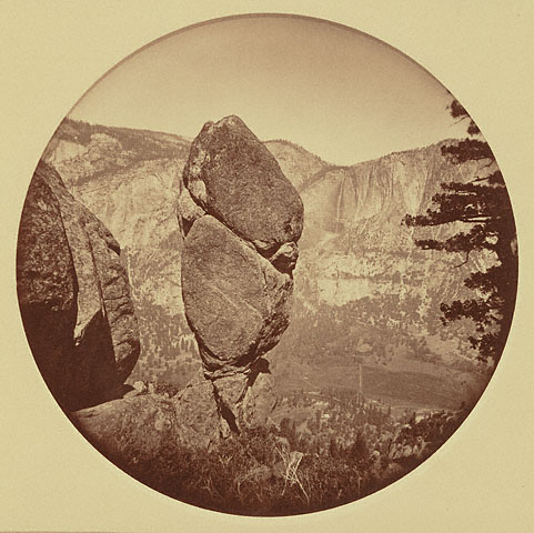
Historical photo of Agassiz Column:


and recent photo, from the old trail below Union Point:

(from this thread).

It's far from conclusive that the top two photos are Agassiz Column, but the location of the nearby large trees and general shape of the rock are consistent.

Anyone know what this thing, just above Union Point, is? Presumably some communication facility? There doesn't seem to be power or cabling going to it, unless it's buried along the old water works path.

avatar Re: Moran Point and the Old Four Mile Trail (was Re: Old Big Oak Flat Road question)
September 29, 2011 08:13PM
For those who may not know who Louis Agassiz was:
http://en.wikipedia.org/wiki/Louis_Agassiz
avatar Re: Moran Point and the Old Four Mile Trail (was Re: Old Big Oak Flat Road question)
September 29, 2011 09:25PM
Quote
basilbop
Here's the rock I believe to be Agassiz Column:


Although it's hard to tell, in the second picture, the Union Point railing is (barely) visible between the two tall trees.

I not sure if the one above is it. (Also I can't see the railing that you mention.)


Quote

Here's another view (or another rock...), further up the trail, from the side:


This one I'm more certain about--note the "dimple" in the center of the rock above and on the right side in the following pictures:

Yes, that's it!

I have two similar shots of it too:


Quote

Historical photo of Agassiz Column:


and recent photo, from the old trail below Union Point:

(from this thread).


The other reason why I don't think the rock right next to Union Point is Agassiz Column is that the person who took the above photo in 2007 would probably had pointed that out. By the description of his account how to get to the rock, it's a bit father away from Union Point than the rock that's right next to Union Point.


Quote

Anyone know what this thing, just above Union Point, is? Presumably some communication facility? There doesn't seem to be power or cabling going to it, unless it's buried along the old water works path.


I wondered about that too. I think though that this possible radio tower could be actually installed adjacent to the old alignment of the Four Mile Trail that went past Moran Point. Just a hunch on my part.


Edited 1 time(s). Last edit at 09/29/2011 09:29PM by plawrence.
Re: Moran Point and the Old Four Mile Trail (was Re: Old Big Oak Flat Road question)
September 29, 2011 11:13PM
Quote
plawrence
Quote

Anyone know what this thing, just above Union Point, is? Presumably some communication facility? There doesn't seem to be power or cabling going to it, unless it's buried along the old water works path.


I wondered about that too. I think though that this possible radio tower could be actually installed adjacent to the old alignment of the Four Mile Trail that went past Moran Point. Just a hunch on my part.

That's a passive microwave reflector, also known as a mirror. You aim a microwave beam at it, and angle it so that the beam bounces back to your receiver somewhere else. It doesn't take any power. It's just a sheet of metal. They are common at ski resorts. Of course, both transmitter and receiver have to be able to see the front of the mirror.
Re: Moran Point and the Old Four Mile Trail (was Re: Old Big Oak Flat Road question)
September 29, 2011 11:32PM
Quote
basilbop
Here's the rock I believe to be Agassiz Column:


Although it's hard to tell, in the second picture, the Union Point railing is (barely) visible between the two tall trees.

Well, the railing is certainly there, although the camera exposure could have been better


Are we to understand that the rock in this photo is the same rock that we see next to the historical photo? If so, then this certainly is Agassiz Column, and another reason why the park service should trim back the brush and trees around the railing at Union Point....
avatar Re: Moran Point and the Old Four Mile Trail (was Re: Old Big Oak Flat Road question)
September 30, 2011 12:50AM
Quote
wherever

Well, the railing is certainly there, although the camera exposure could have been better


Are we to understand that the rock in this photo is the same rock that we see next to the historical photo? If so, then this certainly is Agassiz Column, and another reason why the park service should trim back the brush and trees around the railing at Union Point....

The one thing that makes me wonder if this rock, that is so close to Union Point, is actually Agassiz Column is why all the beta I've read on how to reach it, like from the person who took that 2007 photo of it, involves much more hiking than just going to Union Point and hiking around railing, which looks possible from the westside of Union Point (though there is definitely some exposure involved because you would be climbing around the Union Point rock wall).

Approaching that rock from the eastside of Union Point would be nearly impossible now (even though that's how the old Four Mile Trail alignment reached Union Point from the valley) because that area of Union Point is just too overgrown with manzanita.

Here's how "Dan" (who took the 2007 photo) reached Agassiz Column:

Quote
Dan

Here's how to get there. Its above the current Four Mile Trail (and just below the old Four Mile Trail, which was rerouted in the 1930s, I believe). I hiked up from the Valley Floor, but it's much easier to hike down from the top and back. At the point in the trail near the top where the trail switches from the west-facing switchbacks to the east-facing shaded part of the upper Four Mile trail is a viewpoint, not signed, but I think is near the old Union Point. About 100 feet up the viewpoint is a metal gate. Another 100 feet or so up is a sandy, east-facing slope above the Four Mile trail (on the right, heading up the trail). Carefully climb up the slope, taking responsibility for your own safety. About 20-30 feet up is the old Four Mile Trail. Stay on the old trail, which switchbacks up to the top of a ridge after 200 feet or so. The trail is covered with several inches of pine cones and needles, but is clearly visible and is free of brush on this segment of the trail. At the top of the ridge, on your right as you head up (north) is the top of a rock wall and Agassiz Column. It's surrounded by Manzanita brush and a few fir trees.
avatar Re: Moran Point and the Old Four Mile Trail (was Re: Old Big Oak Flat Road question)
September 30, 2011 01:35AM
Quote
Dan

At the top of the ridge, on your right as you head up (north) is the top of a rock wall and Agassiz Column..

Here's an old stereoscopic photograph that matches Dan's description of going up the old Four Mile Trail and viewing Agassiz Column on the right of the trail. On the lower lefthand corner of this photograph you'll noticed the old Four Mile Trail turning a tight corner of a switchback with Agassiz Column on the righthand side of the trail (before switchback turn).

avatar Re: Moran Point and the Old Four Mile Trail (was Re: Old Big Oak Flat Road question)
October 09, 2011 08:42AM
All the photos shown are Agassiz Column. Every single one. Spot on.
Fairly trivial to get to imo.


If you so inclined... the old trail is not toooooo bad... (at least it's not ALL Manz).. and you can
follow it all the way to the 4 Mile trail. YMMV (go down... not up wink )


Chick-on is looking at you!
Kewl, thanks for the postcard! Good sleuthing! Unfortunately, I have to help launch a new website, so not much exploring for awhile :-(. Where did you pick up the old 4 Mile Trail heading down? My guess was that it should start almost at the Union Point railings heading north, but I didn't see anything definitive through all the manzanita.
avatar Re: Moran Point and the Old Four Mile Trail (was Re: Old Big Oak Flat Road question)
October 09, 2011 05:26PM
Basil, You are welcome. I was thinking it took you a bit of time to even find the beginning of the trail at the bottom.
It comes out in the middle of a switcher and there is no indication of trail there. Honestly is wasn't horrendous
coming down... but going up would be fun (I was actually gonna go up this trail to avoid on Av. zone early this
year... but the ranger refused me... (so I just did full Pohono instead)). I almost want to bring sheers and
fix it up some... most of the trail is in incredible shape and has some very cool switchbacks and rock work.
To get to it from Union Pt... just zig almost due east from the big open area (old comfort station location).
Luckily it's pretty quick to it... and is fairly open once on it... only one spot east of Agas is overgrown then
it's smooth sailing for a long way... and if you really wanted to you could just drop down onto the
new trail near where they close the trail.
You can see Agassiz Column and the old trail from Union Pt.... just need to do a bit of jumping on rocks:

As for the Column itself... the pictures don't due it much justice. It's pretty darn kewl.
You can hike down a v. steep gully right to it and around to the front. A small class 3 move and you are
on the north side of it. Since you can see the trail below... the converse is true.
I can spoil it and show more pix if you like... or you can go check it out fur yurself. Enjoy.
And keep xploring.. (and thanks for the reminder) (looks like some clown over on that other board said he was gonna go there)
Half Fun,
Chick-on is looking at you!


Chick-on is looking at you!
Quote
chick-on
Basil, You are welcome. I was thinking it took you a bit of time to even find the beginning of the trail at the bottom.
It comes out in the middle of a switcher and there is no indication of trail there. Honestly is wasn't horrendous
coming down... but going up would be fun

The first time I hiked up the 4MT 20+ years ago, I had the orange USGS topo with both alignments on it and was on the lookout for the old trail. Back then, it was a narrow, but obvious, path through the shrubbery, so I knew where to turn off the trail... Just forgot to bring the clippers :-(

Could the mystery sign be the (former) junction with the spur that went directly from the 4MT to Sentinel Dome?
avatar Re: Moran Point and the Old Four Mile Trail (was Re: Old Big Oak Flat Road question)
October 09, 2011 07:58PM
Quote
chick-on

To get to it from Union Pt... just zig almost due east from the big open area (old comfort station location).


Then what, may I ask?

I ask, because on one my trips this past July, that's exactly what I did. But then I could not see how to get down the rockwall to the rest of the old trail without bushwacking through the thickly grown manzanita. (At times, I can be really clueless in regards to my trail finding skills, so I think my might have missed the obvious route down.)

And if I'm not mistaken (but I could be) there's a pretty obvious short use trail (or maybe part of the old trail) from this point that meets up with the new Four Mile Trail maybe about 40 to 70 feet just east of the current Four Mile Trail - Union Point spur trail junction.


Quote
chick-on

Luckily it's pretty quick to it... and is fairly open once on it... only one spot east of Agas is overgrown then
it's smooth sailing for a long way... and if you really wanted to you could just drop down onto the
new trail near where they close the trail.

You can see Agassiz Column and the old trail from Union Pt.... just need to do a bit of jumping on rocks:


As for the Column itself... the pictures don't due it much justice. It's pretty darn kewl.
You can hike down a v. steep gully right to it and around to the front. A small class 3 move and you are
on the north side of it.

That's what I figured as an alternative route to get to that rock in your photo. I just didn't realize that rock was actually Agassiz Column from looking at it from Union Point. Thanks a bunch for clarifying this.

By-the-way, in your explorations of the Four Mile Trail area this weekend, did you spot any signs of the old alignment of the Four Mile Trail that went past Moran Point as shown on this crop of your map overlay?

avatar Re: Moran Point and the Old Four Mile Trail (was Re: Old Big Oak Flat Road question)
October 09, 2011 09:23PM
Didn't explore Moran or the lower waterworks.... saved those for next time(s)
(plus I wanted to go check out Indian Rock and the Arch)

You can see the Agassiz trail on the USGS Yosemite Valley map linked to below on this site.
That is it... after you go down the switchbacks with the large rock walls... you head almost
due north... skirt west and around to the face of Union and the column... and then it's almost
all shrubbery busting until you're out on the trail. After the switchbacks you lose very little
elevation. There is a couple of spots where rock falls have occurred which may have messed
you up... and then thru the shrubbery you could possibly get stuck... but amazingly the
main trail is there... and it's mostly NOT manzanita... so it's easy to bust through.

Here is more or less what it looks like:


At least that is more or less my recollection.

The USGS Yose Valley map also shows where the "mystery" sign is located.


Chick-on is looking at you!
avatar Re: Moran Point and the Old Four Mile Trail (was Re: Old Big Oak Flat Road question)
October 09, 2011 10:48PM
Thanks for the information.

After reading your post, I think my problem was that I didn't head far enough east from the former comfort station location before I started to look for the way down towards Agassiz Column. Next time, I'll travel a bit more east through the shrubbery to find where the old trail turns north.

Again, thanks for the info. Much appreciated.


Edited 1 time(s). Last edit at 10/09/2011 10:49PM by plawrence.
avatar Re: Moran Point and the Old Four Mile Trail (was Re: Old Big Oak Flat Road question)
October 10, 2011 07:57AM
Now I'm a little confused. Did you get on the old trail?

A few other points.

Unless you're a rock climber... you won't want to go over the railing to Agassiz. I guess you
could maybe rap down though (the seed is now planted in my noggin). To give you an idea,
here's the col. from the gully east of it... the highest rock to the left of the tree... that is
the rock in the photo with the railing in it... Union Pt.


From the gully you can go to the south of the col. and around it to the north... i.e. :


If so inclined can do a little jig to get in front of it and look up:


Just east of the column are a number of very nice switchbacks:


Here's the portion where the bush realllly starts:

(one rock fall is here) (large black blob in crude map above)

Looking up you see the col (same view as from 4 mile at this pt. though):


Prolly too much info. But I like this stuff so you should too.


Chick-on is looking at you!
avatar Re: Moran Point and the Old Four Mile Trail (was Re: Old Big Oak Flat Road question)
October 10, 2011 11:42AM
Quote
chick-on

Now I'm a little confused. Did you get on the old trail?


I'm not sure. Personally, I don't think I did. But I did do what you stated before, "To get to it from Union Pt... just zig almost due east from the big open area (old comfort station location)". That's exactly what I did. But after doing that, I couldn't find a doable way to go further down (and north) to where I saw the old trail below Union Point. So I think I might not have gone as far east as you did from the old comfort station site.


Quote
chick-on

A few other points.

Unless you're a rock climber... you won't want to go over the railing to Agassiz. I guess you
could maybe rap down though (the seed is now planted in my noggin).

...

Prolly too much info. But I like this stuff so you should too.

Oh, I love this stuff too. Definitely NOT too much information. Keep it coming!


avatar Re: Moran Point and the Old Four Mile Trail (was Re: Old Big Oak Flat Road question)
October 10, 2011 06:02PM
There is absolutely NO mistaking if you are on the trail or not. There are about 6 switchbacks with LOTS of rockwork.
I show a bit of shrub just east of Agassiz... I nearly didn't even go thru that stuff... but took off my pack and looked around
and was amazed at how free and clear the trail of switchbacks you almost immediately see after that pt. was.

Should just meet you at GP sometime and can take you thru it... and also check out Moran pt. V. interested in that again now.
The overlay map sure makes it look like there should be lots o switchers above Moran east of current trail.


Chick-on is looking at you!
avatar Re: Moran Point and the Old Four Mile Trail (was Re: Old Big Oak Flat Road question)
October 10, 2011 07:05PM
Quote
chick-on

There is absolutely NO mistaking if you are on the trail or not. There are about 6 switchbacks with LOTS of rockwork.

I'm aware of the part of the trail which I was definitely NOT on. My question is how you got to that part of the trail from Union Point? When I was there in June, I didn't see any direct way except for wading through some extremely thick growth of manzanita.

Quote
chick-on

I show a bit of shrub just east of Agassiz... I nearly didn't even go thru that stuff... but took off my pack and looked around
and was amazed at how free and clear the trail of switchbacks you almost immediately see after that pt. was.

I've seen the switchbacks free and clear east of Agassiz, but not between Agassiz and the junction with the current Union Point spur trail. That's been my problem.

Quote
chick-on

Should just meet you at GP sometime and can take you thru it... and also check out Moran pt. V. interested in that again now.

The overlay map sure makes it look like there should be lots o switchers above Moran east of current trail.

I think I've seen glimpses of part of that old trail from the transverse of the current Four Mile Trail. When I have time, I'll post one of the photos I have that I think shows part of that trail. I've also seen what could be some of those switchbacks on Google Maps and Google Earth satellite photos of the area.


Edited 1 time(s). Last edit at 10/10/2011 09:47PM by plawrence.
avatar Re: Moran Point and the Old Four Mile Trail (was Re: Old Big Oak Flat Road question)
October 10, 2011 09:15PM
Again, it was a quick zig from comfort station heading almost due east.
From there trail heads due north toward Agassiz. Looking at the
photo of the railing and where Agassiz is.. it is darn close.. and I maybe
touched 1 Manz shrub on the way to it... the other shrub just says hello...
it doesn't try kicking you in the groin as you go by like Manz does.
Sorry I didn't take a photo from the rock to the east of the railing.
I will next time. Good luck


Chick-on is looking at you!
Re: Moran Point and the Old Four Mile Trail (was Re: Old Big Oak Flat Road question)
October 10, 2011 08:46PM
This really needs to be spun off. Since we are no longer talking about the OBOF road, or even anywhere near close!
Thanks for the diagram. I gave up (heading up/south) about where the trail first turns east--looks like I still had more bushwhacking to go :-( I'll blame it on having had the wrong daypack--it seemed like every strap and pocket was getting snagged on something every few feet...
avatar Re: Moran Point and the Old Four Mile Trail (was Re: Old Big Oak Flat Road question)
October 10, 2011 06:04PM
My Moto is... if I didn't have to back thru it or crawl for a long way... then it must not have been that bad.

But, I know the feeling of getting straps stuck on shrub. Argh!


Chick-on is looking at you!
avatar Re: Moran Point and the Old Four Mile Trail (was Re: Old Big Oak Flat Road question)
October 10, 2011 07:33PM
Quote
chick-on
But, I know the feeling of getting straps stuck on shrub. Argh!

Old apian saying: At all costs avoid following poultry into manzanita!
avatar Re: Moran Point and the Old Four Mile Trail (was Re: Old Big Oak Flat Road question)
October 09, 2011 05:40PM
On a somewhat related note... there is another "mystery" sign between GP and the junction up to Sentinel Dome.
That is where the old trail / trail to 4 mile trail went. With the snow cover I was only able to find one definitive
piece of trail between Pohono trail and the waterworks trail... (by going this way you can avoid the 2nd
portion of trail which causes the trail to be closed soooo long) (it's supa steep though) (but in trees so safer... )


Chick-on is looking at you!
avatar Re: Moran Point and the Old Four Mile Trail (was Re: Old Big Oak Flat Road question)
October 09, 2011 07:36PM
Quote
Chick-on


Fantastic photograph! Love it!


Edited 1 time(s). Last edit at 10/09/2011 07:37PM by plawrence.
Re: Old Big Oak Flat Road question
September 27, 2011 02:00PM
Quote

At this point, they would transfer to the mule outfit that went down the pack trail [20] to the valley. Note that it descended steeply down to the valley at a point before the great switchback. Chick-On talks about having done some bushwhacking in the area recently, I think.

So, Chick-On: Is this what you bushwhacked down? Knowing you, there must be a gps trace of your hike....
avatar Re: Old Big Oak Flat Road question
September 27, 2011 08:46PM
Quote
wherever
Quote

At this point, they would transfer to the mule outfit that went down the pack trail [20] to the valley. Note that it descended steeply down to the valley at a point before the great switchback. Chick-On talks about having done some bushwhacking in the area recently, I think.

So, Chick-On: Is this what you bushwhacked down? Knowing you, there must be a gps trace of your hike....
I was further west. Directly above the easternmost tunnel on BOFR. Looks like the old pack trail is east of Fireplace Crk.
Going down where I did is worthwhile... very nice and fairly simple.


Chick-on is looking at you!
Re: Old Big Oak Flat Road question
September 16, 2011 03:11PM
Quote
chick-on
It is my understanding that Rainbow View is Oh My Gosh! Pt.
Unfortunately I cannot at the moment find the map with OMG on it.

Everyone is now calling the Lower Yose view point OMG now it seems.

Still haven't found a definitive explanation of this but, just browsing through some Google results, it appears that Oh My Point and Oh My Gosh Point are two different locations. Going through several pages of search results, all OMP references seem to be on the OBOFR (aka, Rainbow View) whereas all refs to OMGP are to the Lower Yose Falls overlook.

The hand-drawn map I posted above is certainly too crude to rely on but it certainly does seem to show OMP as being a mile or so west of Rainbow View. It certainly seems like there SHOULD be a name to the point when you make a sharp right coming out of the changing station and suddenly see the Merced River a couple of thousand feet below. As I said before, clearly not as nice a view as RV but still seems to be deserving of A name. Of course, if every beautiful view in Yosemite had a name, the list of names would be bigger than the San Francisco phone book!
Re: Old Big Oak Flat Road question
June 11, 2012 10:07PM
Has anyone seen any remnants of the old Gentry Station?
avatar Re: Old Big Oak Flat Road question
June 12, 2012 06:35AM
Quote
Ohnivy-Drak
Has anyone seen any remnants of the old Gentry Station?

Take a look at Basil's trip report similar to yours (I presume you didn't look at his picture set):
http://yosemitenews.info/forum/read.php?3,53509


Chick-on is looking at you!
Re: Old Big Oak Flat Road question
June 12, 2012 09:23PM
I believe I read the report, but missed his photo set. Anything left of the Gentry Station though? The foundation, stilts, other pieces of the building, etc?
Sorry, only registered users may post in this forum.

Click here to login