N 37.75497 W 119.69510 on either GE or Acme Mapper.
It's marked on Acme Mapper (under topo function) as just 'falls', and I've been meaning to get up to this area for some time, so this caught my interest.
It's on Cascade Creek, north of the footbridge that goes over the creek by what looks to be a few hundred meters, and it shows up on GE, clearly, as a falls.

The Moon is Waxing Gibbous (56% of Full)
Re: Anybody been to this rather obscure falls?
All posts are those of the individual authors and the owner
of this site does not endorse them. Content should be considered opinion
and not fact until verified independently.
|
Anybody been to this rather obscure falls? June 27, 2012 10:54AM | Registered: 13 years ago Posts: 409 |
June 27, 2012 01:47PM | Registered: 12 years ago Posts: 578 |
|
Re: Anybody been to this rather obscure falls? June 27, 2012 01:52PM | Registered: 13 years ago Posts: 409 |
June 27, 2012 03:24PM | Registered: 15 years ago Posts: 4,173 |
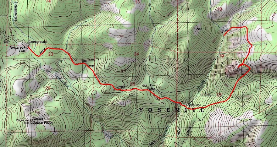
Probably the easiest way to get near that twin waterfall is to follow Wherever's crosscountry El Cap Ridge route (Wherever: White Wolf to Ribbon Meadow via El Cap Ridge [long]) south to the saddle between Waypoints 15 & 16 and then head due west either to an overlook, or a little bit north of west to meet up with one of the streams that lead down to the waterfall.
Here's the map that Wherever provided for his El Cap Ridge route. The twin waterfall is located west of Waypoint 15 where Cascade Creek is joined by the other unnamed creek:

Here's the map that Wherever provided for his El Cap Ridge route. The twin waterfall is located west of Waypoint 15 where Cascade Creek is joined by the other unnamed creek:
June 27, 2012 03:30PM | Registered: 15 years ago Posts: 4,173 |
|
Re: Anybody been to this rather obscure falls? June 27, 2012 04:48PM | Registered: 14 years ago Posts: 755 |
I've been aware of this double cascade (not an overhanging falls) on upper Cascade Creek for a while. It's been on my list of places to go. Next time down the El Cap Ridge, I'll go there. I expect that Chick-on will beat me to it. Thanks for pointing it out.
Here is a less blurry photo from Google Earth, image of April 24, 2010:

Here is a less blurry photo from Google Earth, image of April 24, 2010:
June 27, 2012 08:52PM | Moderator Registered: 14 years ago Posts: 7,421 |
I've mentioned this falls in the past...
http://yosemitenews.info/forum/read.php?3,39010,50991#msg-50991
Have yet to visit it.
The easiest and quickest way is def. NOT El Cap Ridge. It's from Tam Flat CG.
No contest.
I had plans to go to it when did OBOFR/Horse Trail/Fireplace Bluffs... but I just
ran the tank to empty and said "not this time". In hindsight of course I should have
went up that dome... but ended up going up Ribbon Amp instead on 2nd day
after coming down from about 7200 camp spot.
Certain it's one of the those things where you go once and you gotta do it again.
(high water vs. low water)
One thing I'm really wondering... is if this tann guy actually gonna do any of these things
he keeps asking about....
There's also a lot of other interesting items in that "big expanse".
Have fun
June 27, 2012 09:18PM | Registered: 15 years ago Posts: 4,173 |
Quote
chick-on
The easiest and quickest way is def. NOT El Cap Ridge. It's from Tam Flat CG.
No contest.
Which way from the Tamarack Flat Campground?
Cross-country heading, more or less, directly east from the campground, or taking OBOFR to Cascade Creek and then hiking up the Cascade Creek drainage?
I would think that a good time to visit the twin cascades would be in the late spring when there's still lot of water coming down Cascade Creek, but if you went during that time cross-country heading east from the Tamarack Flat CG, then you would have to cross one of Cascade Creek's tributaries before heading around or over x7432 to view the cascades. OTOH, taking the El Cap Ridge route you could avoid any water crossings during the spring runoff.
.
June 27, 2012 10:23PM | Moderator Registered: 14 years ago Posts: 7,421 |
I'd go this way:
Believe me... if you did El Cap Route... by the time you got near Ribbon Meadow... you'd say...
"wth was I thinking"
I'm into lakes... so... when we did El Cap Ridge we visited the 3 near Flat.
By the time we got to 8971 where we camped for the night... we were at over 10 miles with
2K up and 2K down. May not sound like much... but it's really an incredible ridge... and you
will want to stop and smell the granite.
The route on the map above there... confident that can be done any time of the year.
|
Re: Anybody been to this rather obscure falls? June 28, 2012 10:28AM | Registered: 14 years ago Posts: 755 |
OK, now you've got me fired up. But I think that Chick-on's proposed route is not the best way to get there from Tamarack Flat. I would head up the old Mono Trail, which I had mentioned earlier as a possible bushwhack to be done:
http://yosemitenews.info/forum/read.php?3,46585,46999#msg-46999
Here is a quote from that post:
""A generous two-tenths of a mile past the present bridge over Tamarack Creek [traveling west from the saloon at Tamarack Flat] brings one to a well-marked gully leading up on the left. Along this small gulch went the Mono Trail joining Tamarack Flat with Yosemite Creek... ...It was exceedingly rough and steep even after being cleared out and blazed in 1857, but had the advantage of water and shade. Now it is impassable. [This was written in 1959.] Other portions of the Mono Trail have been maintained by the government for modern hikers, but this branch has been forgotten and is recognizable only by the blaze marks about six feet up on the large trees. Many of them have fallen and disintegrated but such marks as are left are always to be found on the right of the trail no matter in which direction one is traveling. [Meaning that they didn't blaze both sides of the same tree.] About a mile up the hill the trail goes through "Split Rock" which looks as if it had been divided for the purpose." Some interesting bushwhacking to be done there. Do any of the blazes still exist fifty years after the book was written? I have found some very interesting rock formations in that area, but don't recognize that one...."
That's the same post where I brought up the subject of the telegraph line, which we later found running along the old Big Oak Flat horse trail.
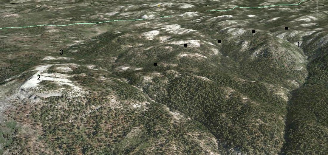
If you look at Chick-on's map above, the little gully would be at the benchmark 6338. That's probably why the benchmark was placed there, since all the others along the old road are at named places. You can see that the route up from there is ever so much less steep than chick-on's bushwhack farther east. A look at Google Earth shows that the route would have a lot of smooth granite, and would also miss the fearsome brush that I once swam through in the next gully to the east, the one that leads straight down to Tamarack Flat. You can assume that the old pack trail would run through the easiest terrain around.
Here is a photo from Google earth. The dots show where I think the old Mono Trail ran. In the upper right, "1" is the double falls in question. For orientation, "2" is the Devil's Dance floor, and "3" is Tamarack Flat.
Edited 1 time(s). Last edit at 06/28/2012 01:43PM by wherever.
http://yosemitenews.info/forum/read.php?3,46585,46999#msg-46999
Here is a quote from that post:
""A generous two-tenths of a mile past the present bridge over Tamarack Creek [traveling west from the saloon at Tamarack Flat] brings one to a well-marked gully leading up on the left. Along this small gulch went the Mono Trail joining Tamarack Flat with Yosemite Creek... ...It was exceedingly rough and steep even after being cleared out and blazed in 1857, but had the advantage of water and shade. Now it is impassable. [This was written in 1959.] Other portions of the Mono Trail have been maintained by the government for modern hikers, but this branch has been forgotten and is recognizable only by the blaze marks about six feet up on the large trees. Many of them have fallen and disintegrated but such marks as are left are always to be found on the right of the trail no matter in which direction one is traveling. [Meaning that they didn't blaze both sides of the same tree.] About a mile up the hill the trail goes through "Split Rock" which looks as if it had been divided for the purpose." Some interesting bushwhacking to be done there. Do any of the blazes still exist fifty years after the book was written? I have found some very interesting rock formations in that area, but don't recognize that one...."
That's the same post where I brought up the subject of the telegraph line, which we later found running along the old Big Oak Flat horse trail.
If you look at Chick-on's map above, the little gully would be at the benchmark 6338. That's probably why the benchmark was placed there, since all the others along the old road are at named places. You can see that the route up from there is ever so much less steep than chick-on's bushwhack farther east. A look at Google Earth shows that the route would have a lot of smooth granite, and would also miss the fearsome brush that I once swam through in the next gully to the east, the one that leads straight down to Tamarack Flat. You can assume that the old pack trail would run through the easiest terrain around.
Here is a photo from Google earth. The dots show where I think the old Mono Trail ran. In the upper right, "1" is the double falls in question. For orientation, "2" is the Devil's Dance floor, and "3" is Tamarack Flat.
Edited 1 time(s). Last edit at 06/28/2012 01:43PM by wherever.
June 28, 2012 08:47PM | Moderator Registered: 14 years ago Posts: 7,421 |
That's ok. There's a method to my madness. I'm not gonna nitpick about it.
Reason I put that way was to get to the base of the falls without having to cross the creek.
And, more importantly, check out the top of that dome.
Nice loop would be come back your way.
I had some grandious plan to start at SF Tuol. and do a loop in order to check out the
WL lakes in that area along with the falls. With the recent fire along Tamarack it would
be even more interesting imho.
O well... too many options is a good thing.
|
Re: Anybody been to this rather obscure falls? June 28, 2012 12:29PM | Registered: 13 years ago Posts: 409 |
Quote
chick-on
I've mentioned this falls in the past...
http://yosemitenews.info/forum/read.php?3,39010,50991#msg-50991
Have yet to visit it.
The easiest and quickest way is def. NOT El Cap Ridge. It's from Tam Flat CG.
No contest.
I had plans to go to it when did OBOFR/Horse Trail/Fireplace Bluffs... but I just
ran the tank to empty and said "not this time". In hindsight of course I should have
went up that dome... but ended up going up Ribbon Amp instead on 2nd day
after coming down from about 7200 camp spot.
Certain it's one of the those things where you go once and you gotta do it again.
(high water vs. low water)
One thing I'm really wondering... is if this tann guy actually gonna do any of these things
he keeps asking about....
There's also a lot of other interesting items in that "big expanse".
Have fun
Yeah, I'm getting around to them, slowly.
Thing is, when you have a pro photographer for a girlfriend, you have to split time with all sorts of other places, like the four corners area, Death Valley, Olympic National Park, etc....
June 28, 2012 08:36PM | Moderator Registered: 14 years ago Posts: 7,421 |
|
Re: Anybody been to this rather obscure falls? June 28, 2012 12:52PM | Registered: 13 years ago Posts: 409 |
|
Re: Anybody been to this rather obscure falls? June 28, 2012 01:41PM | Registered: 14 years ago Posts: 755 |
Quote
tanngrisnir3
Oh, and while we're at it, has anyone ever been to a smallish lake/pond that appears to be the source of Cascade Creek?
It's at N 37.79293 W 119.68540
Pretty close to the 120 and it looks interesting.
Well, I've passed by it, while hiking the county line (which is the boundary between the Merced and Tuolumne drainages, one of the El Cap Ridge variants). It may be a shallow pond in the Spring, but most of the time it is mostly swamp. Here is a satellite image from August, seven years ago:

Sorry, only registered users may post in this forum.

