Welcome! Log In Create A New Profile Recent Posts
Fern on the Four Mile Trail, Yosemite National Park

The Moon is Waxing Gibbous (79% of Full)


Advanced

The Easy Off-Trail hike to Mt Watkins (long)

All posts are those of the individual authors and the owner of this site does not endorse them. Content should be considered opinion and not fact until verified independently.

The Easy Off-Trail hike to Mt Watkins (long)
June 29, 2012 11:40PM
While recently compiling my list of off-trail hikes near Yosemite Valley (see link), I was surprised to find no good links to the very easy off-trail hike from the quarry on Tioga Pass Road to Mount Watkins. This is such a nice easy hike, with such spectacular views, that I just had to dig around and find some info and photos on it. This is the hike that we take visiting family members on, when they complain that all the usual trails are full of people in the summer. You may see a few people on this hike, in the summer, but it could never be called "crowded".

From the highway to the northeast summit of Watkins is two miles, with a drop in elevation of 400 feet. The walk is down an open ridge, very easy going, to the saddle behind the summit, then an easy walk on granite and grass to the top. From there you have incredible views of the Pywiack Cascade in Tenaya Canyon, of Clouds Rest, of Half Dome and North Dome and Basket Dome, and all the rest.

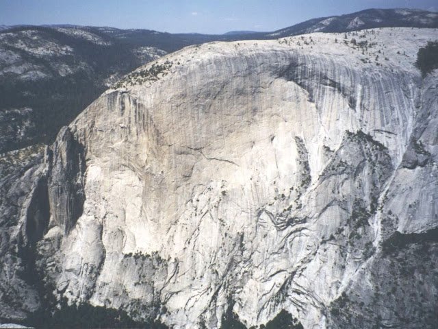
First a couple words about Mount Watkins. It is a lot like El Capitan, except it doesn't have any roads and trail along its base. Like El Capitan, it has a smooth granite face 3000 feet tall. The main summit is 4500 feet above Yosemite Valley. From there you walk along two major branches of the mountain. The Northeast Summit looks down at Pywiack Cascade. Here is the view looking back up at the Northeast Summit from near Pywiack Pool at the cascade's bottom:


and the corresponding view looking down from Mt Watkins, with Pywiack Pool just peeking out from Airplane Gully.:


The usual route down Tenaya Canyon traverses over to the right edge of the photo, then diagonally downward to the left. That little speck about a third of the way down the cascade is actually a rather large pothole cave, as a long lens will prove:


Mount Watkins is a splendid sight from Clouds Rest:


That is a view of Watkin's main summit and the south ridge leading from it. Note the Watkins Pinnacles along its left edge.

But the view of the face of Clouds Rest from Mt Watkins shows a few wrinkles:


OK. Enough tourist photos. You can take your own photos. Here is what you need to know. Mt. Watkins (like North Dome) forms the south end of a long ridge that goes right up to Tioga Pass Highway. You can park there, instead of way over at Olmstead Point. You should park in the large pullout area on the north side of the highway at a big bend and road cut. This is an official trail head, just not one intended for Mt. Watkins. At the east end of the road cut is a gated road into a quarry that was used in building the highway. The quarry itself is hidden from the road, but you will follow a pack trail that goes up and along the top edge of the quarry, then follow the trail until it foolishly takes a right turn and heads off down hill to the west. At that point, you walk ahead down the ridge until you hit the trail from Olmstead Point at the slight saddle behind the peak. If you keep your eyes open, you will observe that you are following a cross country ski route with small metal flags up high in the trees along the east side of the ridge.

The quarry:


The highway is in a road cut just off the the right. The trail runs above the quarry on the ridge.


Here A1 is the parking area, A2 is along the existing pack trail, A3 is where you clearly see that the saddle is slightly to the left. As you start up the dome at A4, you can decide whether to go the the Northeast Summit at A6 first, or to the true summit at A7. From the true summit, you will continue down the south ridge towards Half Dome until you are happy with the view. Eventually you will be able to see right down into gorge of Tenaya Canyon.

Here is the profile from the highway to the Northeast Summit:


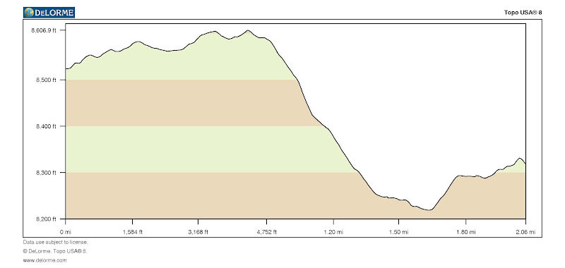
You can see that the saddle is only 400 feet below the highway.

When we do this hike, the geezers then go back to the car, but the young bucks head back towards the saddle and then down the Snow Creek Trail to the valley.

From Half Dome:


5 is the parking area. 1 is the true summit. 2 is the northeast summit. 3 is the usual viewpoint on the south ridge. 4 is as far back as you need to go if you are heading down to the Snow Creek Trail. You can head directly down from there.
avatar Re: The Easy Off-Trail hike to Mt Watkins (long)
June 29, 2012 11:45PM
Wow, beau-tee-full, and very informative.
Re: The Easy Off-Trail hike to Mt Watkins (long)
July 01, 2012 12:17PM
Coolio.

You know, I've seen it on maps countless times, usually in reports like this, and I've been close to it at Olmsted, but I've never actually seen a pic of 'Hidden Lake'.

Can you see it from the trail, or is it too, well, hidden?
avatar Re: The Easy Off-Trail hike to Mt Watkins (long)
July 01, 2012 12:43PM
Quote
tanngrisnir3
Coolio.

You know, I've seen it on maps countless times, usually in reports like this, and I've been close to it at Olmsted, but I've never actually seen a pic of 'Hidden Lake'.

Can you see it from the trail, or is it too, well, hidden?

It is not visible from the trail but it is an easy few minutes to get to it.


Old Dude


Edited 1 time(s). Last edit at 07/01/2012 11:29PM by mrcondron.
Re: The Easy Off-Trail hike to Mt Watkins (long)
July 01, 2012 04:35PM
Thanks for this. Watkins is, perhaps, my favorite mountain of all. I believe it was Secor that turned an easy hike into a difficult one by going down the steep gully between Watkins side buttress and the main mountain, down into Tenaya Canyon. Any crazies have successfully navigated down that insane path?
Re: The Easy Off-Trail hike to Mt Watkins (long)
July 01, 2012 10:15PM
Quote
Ohnivy-Drak
Thanks for this. Watkins is, perhaps, my favorite mountain of all. I believe it was Secor that turned an easy hike into a difficult one by going down the steep gully between Watkins side buttress and the main mountain, down into Tenaya Canyon. Any crazies have successfully navigated down that insane path?

Secor writes mountaineering guides. I haven't seen that particular quote, but I have read an account, at least a hundred years old, by a fisherman who spent a week up in Lost Valley (above the first rappel), who said that he had checked out several different routes up to the rim on the Watkins side of the canyon. Only one of those could have been Airplane Gully. The route that you mention looks possible from a distance, but very steep in places and very bushy in others. You would have to go there and check it out, and probably be willing to do some seriously steep friction pitches.
Re: The Easy Off-Trail hike to Mt Watkins (long)
July 02, 2012 10:14PM
You're right, it wasn't Secor. I think it was an Italian guy that went down that Watkins gully. It was not a good idea, he nearly lost his life. I'll think of the name at some point, lol.
Re: The Easy Off-Trail hike to Mt Watkins (long)
June 19, 2015 04:30PM
Here are some additional comments to the thread about the easy hike to Mount Watkins.
see: http://yosemitenews.info/forum/read.php?3,57351
My buddy and I have often been asked about how to find the two mile long, relatively flat (500 vertical feet) route out to Mount Watkins from the Tioga Road (Rt.120). We had occasion to do it again yesterday, as a short excursion prior to driving back to the Bay Area. In the three years since that original post, there has been some increase in traffic along this unmarked use trail, so it is much easier to see on the ground. That's good, because although it follows a cross country ski trail, which is marked by occasional old auto license plates nailed up in the trees, there seem to be a lot fewer of those tags these days.

Not that you could get lost, if you have any wits. There is only the single ridge running from Mount Watkins towards Mount Hoffman. When you want to return, just get on the ridge and follow it back up to the highway. However, there is some steep shingle (west of 2 in the photo below) on the end of the ridge just above the Mount Watkins saddle, and the use path runs along the east side of the ridge, descending towards a visible rock knob to avoid that steeper pitch at the end.

Here is what I'm talking about:


You will find a topo map of the route and a vertical profile in the original post at the head of this thread. This view from Google Earth may give you a better perspective. You car will be at the quarry or the trail head at 6. The initial route follows the maintained stock trail between Snow Creek and May Lake. But at 1, the horse trail turns sharply right and plunges off the ridge to the west. Looking for water, no doubt. At this point, step over some sticks that were laid to delineate the horse trail, and continue along the ridge. Almost immediately the use trail (ski trail) drifts down the left side of the ridge. It is an easily recognizable path. As you approach the intermediate knob of granite 2, the ski trail turns right slightly before the use trail does, but either works fine. In this photo I show a descending trace that approaches the knob, and a return trace that more correctly follows the ski track. Both routes have plenty of foot tracks.


In the above photo, you can clearly see a maintained park trail crossing below the knob. It runs between Olmstead Point and Snow Creek, and passes through the saddle next to Mount Watkins at point 3 in the upper photo. From the vicinity of the knob, you will see Mount Watkins off to the right. Follow the use trail to where it crosses the park trail at 3, then start up the easy hill to the summits.

I recommend doing the Northeast summit 4 first. To get there, go half way up to the true summit on the use trail, then head diagonally to the left. The usual mistake is to head left too soon. This works OK, but leads you through a boulder maze. It's easier to stay on the main route, keeping an eye on the slight gully to your left until that levels off, then cross the small resulting saddle before it turns downward into a steep gully heading east. The use trail does not go to the northeast summit.

The best views are not at the highest point on the northeast summit, but a bit farther out, as demonstrated by the gps track. Along its northern rim there are some convenient slabs to sit on with a fabulous view to the north.


It's easy to return to the use trail and head up to the true summit. From that broad summit, most people continue down the south ridge to get a better look at Half Dome, etc. There are plenty of photos elsewhere on this forum of the wonderful views to be had from Mount Watkins. They are obtained with vastly less effort expended than you would use, for example, getting to the top of North Dome or Clouds Rest.

As for people, you won't meet them. We did see some climbers camped way down the ridge towards Watkins Pinnacles, but other than that we had the place to ourselves. It was a tremendous contrast from the day before on Clouds Rest, which had at least three dozen people crowding the summit, and dozens more going both ways on the trail.

Here is more info on the start of the hike:


This is a Google Earth view of the gps trace near the highway. There is lots of parking available at the road cut, which is on the highway between Olmstead Point and the road entrance to May Lake. Coming from the west, it's not far beyond Porcupine Flat. At the parking area, you will see marked trails to May Lake on the north side and to Snow Creek and Yosemite Valley on the south side.

In the photo, the upper trace is the official trail. But horse people can get a key for the vehicle gate to the quarries. All of them and most hikers start via the quarry entrance road. Take the right driveway fork towards the upper quarry, and then follow the use trail up the hill between the quarries.

As far as I can tell, nothing has been quarried for a long time, but the park service does store some heavy equipment there sometimes.


Edited 2 time(s). Last edit at 07/23/2015 03:05PM by wherever.
Re: The Easy Off-Trail hike to Mt Watkins (long)
August 30, 2015 01:39PM
Hello.
It would be really great to have the GPS coords for A1-A7.

Thanks.
Re: The Easy Off-Trail hike to Mt Watkins (long)
August 30, 2015 10:21PM
Quote
cotati
Hello.
It would be really great to have the GPS coords for A1-A7.

No guarantees:

These are from the Google Earth view, not the earlier topo map view.

1 leave the horse trail, follow ski trail N37.803, W119.5136
2 saddle by small knob 37.797, 119.5096
3 Watkins Saddle, crossing of the major park trail 37.7933, 119.5097
3A leave use trail and head towards NE summit 37.7888, 119.5112
4 NE summit viewpoint 37.7841, 119.5080
5 main summit 37.7833, 119.5168
6 parking area at road 37.812, 119.509

This is very open country. It's really tough to get lost in it. But if you want to go straight from one waypoint to the next, that works fine.

Most people continue quite a long way down the ridge beyond the main summit to get more views of Half Dome and Tenaya Canyon.


Edited 1 time(s). Last edit at 08/31/2015 02:41PM by wherever.
Sorry, only registered users may post in this forum.

Click here to login