
The Moon is Waxing Gibbous (55% of Full)
Re: Cascade Fire Update
All posts are those of the individual authors and the owner
of this site does not endorse them. Content should be considered opinion
and not fact until verified independently.
July 05, 2012 10:19AM | Admin Registered: 15 years ago Posts: 17,050 |
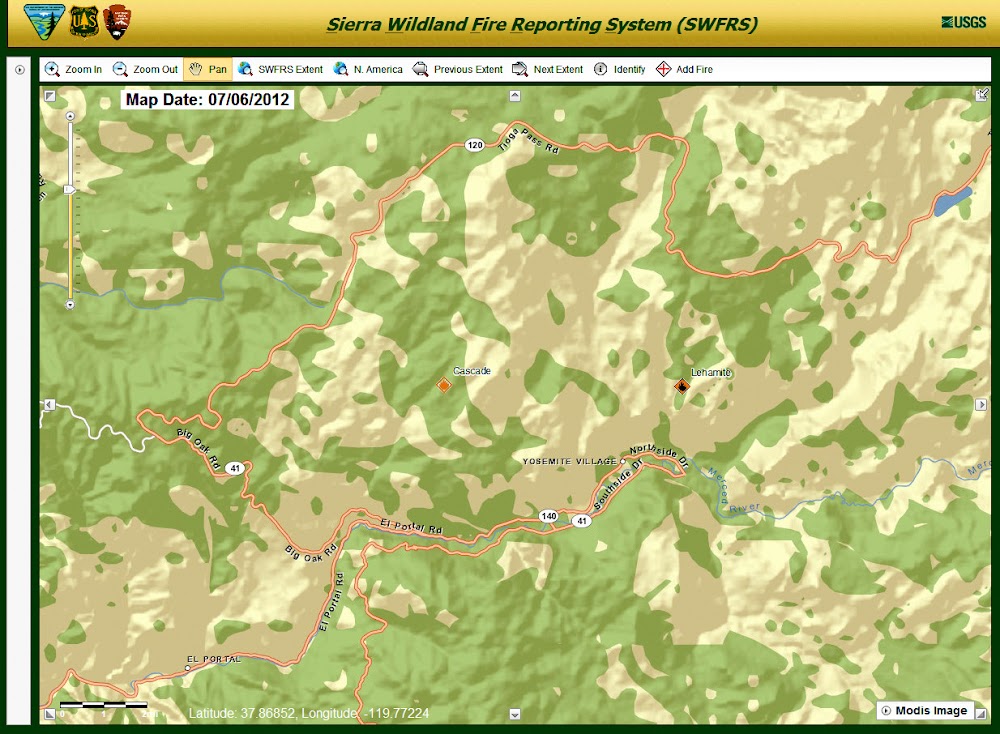
Yosemite firefighters hiked into the remote Cascade fire to map, monitor and obtain fuel moistures today. This fire began from a lightning ignition on June 19, 2012. The fire is at the 7,800’ elevation and in two weeks it has slowly grown to approximately 13 acres. Today the fire is active on the northeast and southern perimeters, burning in duff, needle litter and brush within a predominately red fir forest. Fuels are patchy, and six to 12 inch flame lengths were observed in brush patches. Most of the fire activity is smoldering and creeping through ground fuels. The immediate area has no fire history; however, it is surrounded by previous fire footprints and considerable granite. Light smoke may be visible.
|
Re: Cascade Fire Update July 05, 2012 11:06AM | Registered: 14 years ago Posts: 755 |
Quote
eeek
Yosemite firefighters hiked into the remote Cascade fire to map, monitor and obtain fuel moistures today. This fire began from a lightning ignition on June 19, 2012. The fire is at the 7,800’ elevation and in two weeks it has slowly grown to approximately 13 acres. Today the fire is active on the northeast and southern perimeters, burning in duff, needle litter and brush within a predominately red fir forest. Fuels are patchy, and six to 12 inch flame lengths were observed in brush patches. Most of the fire activity is smoldering and creeping through ground fuels. The immediate area has no fire history; however, it is surrounded by previous fire footprints and considerable granite. Light smoke may be visible.
Does anyone know where this is? A web search turns up plenty of "cascade fires", but none of them are this year, and none of them could be considered "remote"...
|
Re: Cascade Fire Update July 06, 2012 09:25AM | Registered: 14 years ago Posts: 755 |
July 06, 2012 07:41PM | Registered: 15 years ago Posts: 4,173 |

July 10, 2012 10:23AM | Admin Registered: 15 years ago Posts: 17,050 |
The June 19th lightning ignited Cascade Fire has slowly grown to 30 plus acres. Yosemite fire crews are hiking into the remote fire early today to map and monitor the fire from the ground. The fire is now at the 8,000’ elevation, and is active on the northeast and southern perimeters. It is smoldering and creeping through duff, needle litter and brush within a predominately red fir forest. Fuels are patchy, and six to 12 inch flame lengths were observed in brush patches. The immediate area has no fire history; however, it is surrounded by previous fire footprints and considerable granite. Light smoke had been visible from various locations within the park, predominately in the morning hours.
|
Re: Cascade Fire Update July 10, 2012 01:16PM | Registered: 11 years ago Posts: 15 |
July 14, 2012 02:14PM | Admin Registered: 15 years ago Posts: 17,050 |
This lightning caused fire has been slowly burning for the last month in Yosemite’s high elevation Wilderness. It started during an afternoon thunderstorm on June 15th. The fire is at approximately 33 acres, and is burning in short needle red fir forest between two upper forks of the Cascade Creek. Since June 16, the fire has slowly smoldered through sparse surface fuels of duff, forest litter and occasionally creating enough heat to ignite brush. The northeast perimeter edge is the most active with 6 to 12 inch flame lengths during the hottest part of the day. The fire poses no threat to trails, park service buildings, infrastructure or roads.
The fire could potentially grow to 1000 acres over the next month due to typical warm and dry weather for this time of year. Firefighters have hiked into the fire area to scout and determine the potential in growth and spread direction. Although the immediate fire area has a history of lightning, there is no recorded recent large fire history. Normally fuels too wet during this time of year to support active fire growth. Due to light winter snowpack this year, fuels at this elevation are now able to support fire spread and allow this natural fire to play a vital role in Yosemite Wilderness. The nearest historic fire to the Cascade Fire suggest that fires at this elevation, in this forest type, creep and smolder for weeks and only make runs during dry windy conditions.
Red fir forests burn about every 30 years. Cascade Fire is burning in an area that has not burned in at least 60-90 years. Because there are no resources threatened at this time or in the near term future, allowing this fire to burn in this area, this year promotes healthy, resilient ecosystem function. If resources are threatened, and/or smoke impacts threaten human health, fire managers will reassess the objectives of this fire.
Light smoke has been visible mainly in the morning hours near Cascade Falls and the community of Foresta. Smoke may become more visible at high locations within the park. Fire managers are working closely with state and local air pollution regulators concerning potential adverse air quality impacts to nearby smoke sensitive areas. Yosemite’s Division of Resources Management and Sciences personnel have installed air quality monitoring equipment within the communities of Lee Vining, Hodgdon Meadow, El Portal and Yosemite Valley. The park’s webcam located at Crane Flat Helibase will capture fire images, which can be viewed at: http://ssgic.cr.usgs.gov/dashboards/WebCam.htm
July 18, 2012 03:08PM | Admin Registered: 15 years ago Posts: 17,050 |
The June 19th lightning ignited Cascade continues to slowly grow. It is now at approximately 40 acres. Yosemite fire crews are hiking into the remote Cascade fire over the weekend to monitor its progress. The fire is at the 7800’ elevation. The fire is most active on the southern and northeast perimeters, burning in duff, needle litter and brush within a predominately red fir forest. Fuels are patchy, and six to 12 inch flame lengths have been observed in brush patches. Most of the fire activity is smoldering and creeping through ground fuels. The immediate area has no fire history; however, it is surrounded by previous fire footprints and considerable granite. Light smoke had been visible from various locations within the park.
July 27, 2012 03:03PM | Admin Registered: 15 years ago Posts: 17,050 |
This lightning caused fire has been slowly burning since June 16, in Yosemite’s high elevation Wilderness. It started during an afternoon thunderstorm on June 15th. The fire has grown to 109 acres. It is burning in a short needle red fir forest between two upper forks of the Cascade Creek. The fire has slowly smoldered through sparse surface fuels of duff, forest litter and occasionally creating enough heat to ignite brush. The southern perimeter edge is the most active with occasional 6 to 12 inch flame lengths during the hottest part of the day. The fire poses no threat to trails, park service buildings, infrastructure or roads.
The fire could potentially grow to 1000 acres over the next month due to typical warm and dry weather for this time of year. Firefighters continue to monitor and scout the fire to determine the potential in growth and spread direction. Although the immediate fire area has a history of lightning, there is no recorded recent large fire history. Normally fuels too wet during this time of year to support active fire growth. Due to light winter snowpack this year, fuels at this elevation are now able to support fire spread and allow this natural fire to play a vital role in Yosemite Wilderness. The nearest historic fire to the Cascade Fire suggest that fires at this elevation, in this forest type, creep and smolder for weeks and only make runs during dry windy conditions
The fire could potentially grow to 1000 acres over the next month due to typical warm and dry weather for this time of year. Firefighters continue to monitor and scout the fire to determine the potential in growth and spread direction. Although the immediate fire area has a history of lightning, there is no recorded recent large fire history. Normally fuels too wet during this time of year to support active fire growth. Due to light winter snowpack this year, fuels at this elevation are now able to support fire spread and allow this natural fire to play a vital role in Yosemite Wilderness. The nearest historic fire to the Cascade Fire suggest that fires at this elevation, in this forest type, creep and smolder for weeks and only make runs during dry windy conditions
|
Re: Cascade Fire Update July 30, 2012 08:53PM | Registered: 14 years ago Posts: 755 |

August 02, 2012 09:43AM | Admin Registered: 15 years ago Posts: 17,050 |
The Cascade Fire has slowly grown to 120 acres, as it continues to creep and smoldering through down and dead surface vegetation. Smoke is more visible from many locations in the park. Yosemite fire crews will periodically monitor the Cascade Fire and provide ground GPS mapping and other data.
|
Re: Cascade Fire Update August 05, 2012 06:33PM | Registered: 14 years ago Posts: 755 |
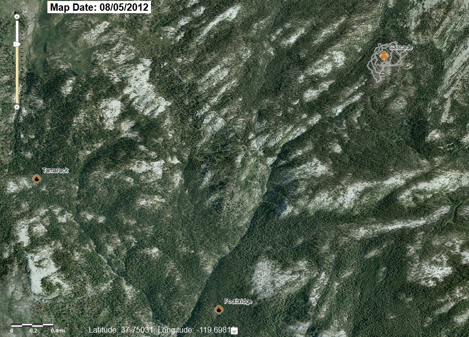
Odd coincidence today. Two new fires showed up on the SWFRS map. I know that there have been thunderstorms recently, but both of these are on the Old Big Oak Flat Road. One seems to be inside the Tamarack Flat Campground. The other is on the old road, more or less where Gentry's Station used to be, i.e., where the El Capitan Trail turns up the hill.
Maybe we will get some info on this during the week...
Maybe we will get some info on this during the week...
|
Re: Cascade Fire Update October 02, 2012 05:12PM | Registered: 14 years ago Posts: 755 |
For those of you who have been watching the smoke south of Tioga Road and east of Tamarack Flat, you maybe interested to learn that the Cascade Fire is still creeping along in its 109th day. After all that time, it's still only one by two miles in size. The fire is doing a dandy job of cleaning up the forest floor without getting up into the trees. Parts of the burned area are ankle deep in ash as fine as goose down....if you step into it you will raise a dust plume higher than your head.
I passed by the fire's south edge on Thursday, since its southern perimeter is exactly at the creek that the old Mono Trail passes along (link).

You can get the latest on InciWeb:
http://inciweb.org/incident/3069/
And some of their photos here:
http://inciweb.org/incident/photographs/3069/
It's October, already. Where are the rains?
I passed by the fire's south edge on Thursday, since its southern perimeter is exactly at the creek that the old Mono Trail passes along (link).
You can get the latest on InciWeb:
http://inciweb.org/incident/3069/
And some of their photos here:
http://inciweb.org/incident/photographs/3069/
It's October, already. Where are the rains?
October 02, 2012 10:15PM | Registered: 15 years ago Posts: 4,173 |
Sorry, only registered users may post in this forum.

