Hope all is well with the forum frequenters. I’m planning a backpacking trip for the end of May, beginning of June and wanted to reach out for any and all information that I can gain. My plan is to start at either Mono Meadow or Glacier Point and do a loop over Red Peak Pass, following Triple Peak Fork down to Washburn lake, Merced Lake, and ultimately looping back to my starting point via the Panorama Cliff Trail.
Ideally I would like to start at Mono Meadow around 12pm on day one, and make it out to Lower or Upper Merced Pass Lake. My concerns about starting at Mono Meadow are crossing Illilouette Creek and the tributary creeks that feed into that drainage.
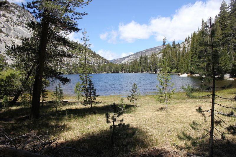
Day two I plan on making it to at least the Triple Peak Fork trail junction—depending on the snow levels, how long I spend on the Peak, and exploring the Ottoway Lakes I may not make this goal. Any recommendations for camping spots if I don’t make it to the trail junction are appreciated. Maybe Red Devil Lake?
Day 3,4,5? I don’t have too much after the first couple days planned. I’m not constrained on time, and will most likely play it by ear—so any recommendations for must-see or favorite spots are welcomed.
I would also appreciate any information on the snow levels in the Clark Range.
Please let me know if any of my questions or trip plans needs clarification, and I thank you all in advance for any information you can provide.

The Moon is Waxing Gibbous (61% of Full)
Re: Red Peak Pass in Late May
All posts are those of the individual authors and the owner
of this site does not endorse them. Content should be considered opinion
and not fact until verified independently.
|
Red Peak Pass in Late May May 19, 2013 09:02PM | Registered: 12 years ago Posts: 129 |
May 20, 2013 06:17AM | Moderator Registered: 15 years ago Posts: 1,876 |
I've not done this route yet but making it all the way from Merced Pass Lakes to Triple Peak Fork in one day w/ snow along the way may be a tall order. From what I understand, this is some of the most attractive parts of the trip so why rush it? It depends on your hiking experience. Red Devil Lake would be a good overnight location and one I plan to use whenever I get around to doing it. There may still be snow at Red Devil.
Jim
Jim
May 20, 2013 07:47AM | Moderator Registered: 14 years ago Posts: 7,421 |
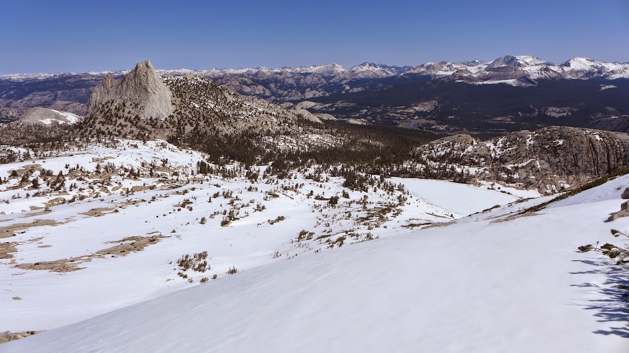
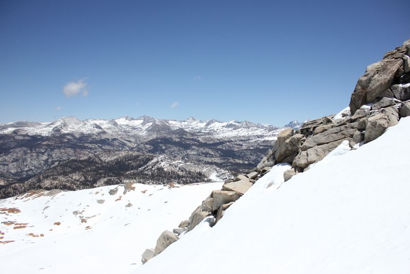
Here's a photo took from near Echo Peaks Saturday (yes, I thought of you up there).

Red Peak is on the right... and JUST to the left of the peak in the middle is your Red Peak Pass.
No way... no how... that much snow goes bye bye in 2 weeks. What need is someone kind enough to
take a picture of Merced Peak from Glacier Pt. or "Clark View" turnoff to give you an idea of
Ottoway. Judging by Matthes, Echo, and the Cath Lakes this weekend... Lower Ottoway is
prob. mostly unfrozen... and Upper Ottoway and above nearly 100% snow... but melting fast.
I'd go with what told you... head from GP ... and go to Ottoway and go from there...
Illilouette and Ottoway creeks before Ottoway ... can be a challenge early... be aware of that.
I would not bring snowshoes... by then the snow will be consolidated and/or sun cupped
such that they will be useless.. microspikes/kahtoolas may be of use.
Your call on crampons and axe... but I'd just go over the pass mid-day-ish...
Whatever you do... take what you think you need and be safe... and have fun...
|
Re: Red Peak Pass in Late May May 20, 2013 09:57AM | Registered: 12 years ago Posts: 953 |
Years ago, and I can't currently recall what year, Basilbop and I did the trip you, Torero14, are proposing, except that we didn't stay at either Merced Pass Lake, but stayed in a burnt out bit of forest, second day was Lower Ottoway... stayed on trail the entire way. It was high summer and no snow, no water crossings of note. I can remember bits and pieces of the trip, especially from Lower Ottoway to Triple Peak Fork, but otherwise not uniquely memorable. We've done the Merced River canyon so many times now, bits and pieces blur together, but it's a favorite!
A few years later, back in 2005, in a high-snow year, on July 4th weekend, we chose to do a variation of the Red Peak Pass Loop. We knew there would be snow and had lightweight instep crampons (I don't recall Microspikes back then...), and light, but "real" ice axes. We had two others hiking with us. We went by Ostrander Lake on trail and then XC until we hit "trail" into Buena Vista Lake. We ran into snow as we hit the trail near Buena Vista and the lake was still iced over and had snow on it. We found a bare (but not really dry) patch of ground and pitched on that. Next day XC over Buena Vista Ridge... which was mostly dry... the talus drove one member nutty and we dropped off the ridge (stunning views) to a more easily-traversed section, which was also dry. As we contoured our way to Merced Pass, the snow picked up but the sign for Merced Pass was visible. Our friends decided to bail and take the trail down to one of the Merced Pass Lakes and haul out from there. Very much the right decision for them, it turned out.
Basilbop and I continued to Lower Ottoway. No snow on the ground, but the creek crossings were FULL. If not raging. There was one, which I think is one of the branches of the beginning of Illilouette Creek, which was roaring. And we hunted long for a log to cross on. And that was a doozy. We butt-scootched over it because it was broken in the middle on a rock above the creek. Our feet barely cleared the log. It made a shallow (though I would have preferred more shallow "V" . It was big. And thankfully solid. At that time, I was not about to try to walk across that ripping water. Would it look as bad to me now? I think still, yes. This wasn't a ford that we even thought about during or remembered from that first drier trip.
The Ottoway creek ford was WIDE and deep and cold. But, thankfully, slow moving at the normal trail ford. We just walked through. Bottom of my hipbelt was at water line - I'm 5'5". It was 7 PM (I remember that. thinking jeez, I'm gonna be wet the rest of the "day". Other than cold and deep, it was not an issue to cross, for which I was very thankful after that last crossing. We scurried to Lower Ottoway and ran into almost 100% snow coverage. We found a flat rock and pitched on that. From that point on, the trip had nearly 100% snow on the "trail". Lower Ottoway was mostly iced with snow, Upper and Red Devil were frozen over with sun cups. We used the instep crampons on the way up and over the pass. The sun cups could help (they were almost like steps, or hurt - if they were too soft to step on the edges, and my foot went in, the "bend" of my shoe wasn't fun. Yes, I was wearing stiff Trail Runners, not boots, and overall, I was thankful, I was! Wet or dry, with the trail runners, we could keep moving.
On the north side of Red Peak Pass, we stupidly tried to take a break on a big exposed rock. Getting onto it and eating was fine. Stepping off, I couldn't reach far enough to strong enough snow and broke through with one leg- and fell on my chest. Not fun, but I was okay. Was reminded to be very wary of any snow/rock junction! Ice axes soon came out and in use instead of hiking poles. It was slow going over the deep sun cups down, but it was freaking lovely. We heard running water under the snow (nothing visible from the top) and avoided the sound best we could.
We camped on a dry rock near Red Devil lake, also iced over with sun cups. Though we'd only gone a few miles since Lower Ottoway, it was mid-afternoon when we settled on the rock. And my lower lip was so swollen I could see it. My nose hurt on the inside (light burn). As carefully as we cover ourselves and try to sunscreen, my runny nose (always runs when I'm active) and hankie had rubbed off the sunscreen, and though I usually re-apply well, with the trickiness of the pass, I didn't try to do that for hours. And I paid a price. I was pretty darned burned. As bad as ever without blisters, thankfully. Painful, though. Backs of my hands were incredibly painful, and I put on thin black windbloc gloves to protect them from the direct rays, which hurt. It was HOT.. July 4 weekend, clear blue sky. Surrounded by snow.
As planned, the next day we XC'd down Red Peak Fork (almost immedialy left snow after Red Devil) to the Merced River and passed some of the lovliest slabs of rock with water sheeting over them. In hindsight, we should have dropped a bit more and camped down there. But gotta say camping on the rocks surrounded by snow was something truly special.
Anyway, after we hit the Merced (which was FULL), we XC'd east to the trail, over the bridge to the other side of the Merced and scooted down the trail to Merced Lake HSC backpacker's camp. We ran into a ranger who was nice, kinda surprised to see us. He did a double-take after reading our permit. We'd been out 3 nights and had crossed a lot of country, which you can't really do without XC. It finally started to click and he asked a few questions. But then he warns us about a flooded creek crossing up ahead and that it was dangerous and we should take care.... Jeez. At this point, I'm freaking DONE with water crossings for the trip and I was very respectful of the power of water... So I'm a bit concerned as we continue on... And it turns out this thing is barely over knee deep, hardly moving and the logs that are "floating" on it are big and hit bottom as soon as you put some weight on them. I could have easily walked through it, but I stepped on the logs and ended up jumping on the big "floating" one to get some of the pent-up adrenaline out. I was a bit miffed, but I realize the rangers play it conservatively.
I have no idea how bad the water levels will be this year. The snow distribution this year is a bit odd.
So, probably TMI... but suggested takeaways: if you think you are facing snow, take the right gear, know how use it. Respect the power of reflected sun! Respect water, frozen or not. Respect the sun. (I wear gloves of one type or another all the time while hiking. Sun gloves are a favorite!) Get to Lower Ottoway as quickly as you can. Take your time through the most glorious section of the trip from Lower Ottoway to past Red Devil Lake. Stunning country with or without snow, IMO. And enjoy the Merced River canyon. Lovely.
Enjoy!
You can see the pretty, but ultimately annoying sun cups and other pics here.
A few years later, back in 2005, in a high-snow year, on July 4th weekend, we chose to do a variation of the Red Peak Pass Loop. We knew there would be snow and had lightweight instep crampons (I don't recall Microspikes back then...), and light, but "real" ice axes. We had two others hiking with us. We went by Ostrander Lake on trail and then XC until we hit "trail" into Buena Vista Lake. We ran into snow as we hit the trail near Buena Vista and the lake was still iced over and had snow on it. We found a bare (but not really dry) patch of ground and pitched on that. Next day XC over Buena Vista Ridge... which was mostly dry... the talus drove one member nutty and we dropped off the ridge (stunning views) to a more easily-traversed section, which was also dry. As we contoured our way to Merced Pass, the snow picked up but the sign for Merced Pass was visible. Our friends decided to bail and take the trail down to one of the Merced Pass Lakes and haul out from there. Very much the right decision for them, it turned out.
Basilbop and I continued to Lower Ottoway. No snow on the ground, but the creek crossings were FULL. If not raging. There was one, which I think is one of the branches of the beginning of Illilouette Creek, which was roaring. And we hunted long for a log to cross on. And that was a doozy. We butt-scootched over it because it was broken in the middle on a rock above the creek. Our feet barely cleared the log. It made a shallow (though I would have preferred more shallow "V"
. It was big. And thankfully solid. At that time, I was not about to try to walk across that ripping water. Would it look as bad to me now? I think still, yes. This wasn't a ford that we even thought about during or remembered from that first drier trip.The Ottoway creek ford was WIDE and deep and cold. But, thankfully, slow moving at the normal trail ford. We just walked through. Bottom of my hipbelt was at water line - I'm 5'5". It was 7 PM (I remember that. thinking jeez, I'm gonna be wet the rest of the "day"
. Other than cold and deep, it was not an issue to cross, for which I was very thankful after that last crossing. We scurried to Lower Ottoway and ran into almost 100% snow coverage. We found a flat rock and pitched on that. From that point on, the trip had nearly 100% snow on the "trail". Lower Ottoway was mostly iced with snow, Upper and Red Devil were frozen over with sun cups. We used the instep crampons on the way up and over the pass. The sun cups could help (they were almost like steps, or hurt - if they were too soft to step on the edges, and my foot went in, the "bend" of my shoe wasn't fun. Yes, I was wearing stiff Trail Runners, not boots, and overall, I was thankful, I was! Wet or dry, with the trail runners, we could keep moving.On the north side of Red Peak Pass, we stupidly tried to take a break on a big exposed rock. Getting onto it and eating was fine. Stepping off, I couldn't reach far enough to strong enough snow and broke through with one leg- and fell on my chest. Not fun, but I was okay. Was reminded to be very wary of any snow/rock junction! Ice axes soon came out and in use instead of hiking poles. It was slow going over the deep sun cups down, but it was freaking lovely. We heard running water under the snow (nothing visible from the top) and avoided the sound best we could.
We camped on a dry rock near Red Devil lake, also iced over with sun cups. Though we'd only gone a few miles since Lower Ottoway, it was mid-afternoon when we settled on the rock. And my lower lip was so swollen I could see it. My nose hurt on the inside (light burn). As carefully as we cover ourselves and try to sunscreen, my runny nose (always runs when I'm active) and hankie had rubbed off the sunscreen, and though I usually re-apply well, with the trickiness of the pass, I didn't try to do that for hours. And I paid a price. I was pretty darned burned. As bad as ever without blisters, thankfully. Painful, though. Backs of my hands were incredibly painful, and I put on thin black windbloc gloves to protect them from the direct rays, which hurt. It was HOT.. July 4 weekend, clear blue sky. Surrounded by snow.
As planned, the next day we XC'd down Red Peak Fork (almost immedialy left snow after Red Devil) to the Merced River and passed some of the lovliest slabs of rock with water sheeting over them. In hindsight, we should have dropped a bit more and camped down there. But gotta say camping on the rocks surrounded by snow was something truly special.
Anyway, after we hit the Merced (which was FULL), we XC'd east to the trail, over the bridge to the other side of the Merced and scooted down the trail to Merced Lake HSC backpacker's camp. We ran into a ranger who was nice, kinda surprised to see us. He did a double-take after reading our permit. We'd been out 3 nights and had crossed a lot of country, which you can't really do without XC. It finally started to click and he asked a few questions. But then he warns us about a flooded creek crossing up ahead and that it was dangerous and we should take care.... Jeez. At this point, I'm freaking DONE with water crossings for the trip and I was very respectful of the power of water... So I'm a bit concerned as we continue on... And it turns out this thing is barely over knee deep, hardly moving and the logs that are "floating" on it are big and hit bottom as soon as you put some weight on them. I could have easily walked through it, but I stepped on the logs and ended up jumping on the big "floating" one to get some of the pent-up adrenaline out. I was a bit miffed, but I realize the rangers play it conservatively.
I have no idea how bad the water levels will be this year. The snow distribution this year is a bit odd.
So, probably TMI... but suggested takeaways: if you think you are facing snow, take the right gear, know how use it. Respect the power of reflected sun! Respect water, frozen or not. Respect the sun. (I wear gloves of one type or another all the time while hiking. Sun gloves are a favorite!) Get to Lower Ottoway as quickly as you can. Take your time through the most glorious section of the trip from Lower Ottoway to past Red Devil Lake. Stunning country with or without snow, IMO. And enjoy the Merced River canyon. Lovely.
Enjoy!
You can see the pretty, but ultimately annoying sun cups and other pics here.
May 20, 2013 05:36PM | Registered: 12 years ago Posts: 578 |
May 20, 2013 06:10PM | Moderator Registered: 14 years ago Posts: 7,421 |
Quote
yosemitejim
Quote
chick-on
Here's a photo took from near Echo Peaks Saturday
Did you take the Budd Creek trail up there? Was snow pretty heavy along Budd Creek?
No. I prefer the shortcut way to Lower Cathedral (we ended up camping there 2 nights)... and
just dayhiking ... circumnavigating Matthes Crest. With plenty of time to do some dome hopping.
As for the 2nd Question... no doubt:
May 21, 2013 12:00PM | Registered: 12 years ago Posts: 578 |
|
Re: Red Peak Pass in Late May June 02, 2013 11:27AM | Registered: 12 years ago Posts: 129 |
I started my trip at 2:00 AM in San Diego, and arrived at the Wawona Visitor Center/ Ranger Station at 8:15 AM to pick up my backcountry permit. Station opened at 8:30, and at 8:45 I was on my way to Glacier Point.
At 10:30 AM I started on the Panorama Trail towards Nevada Falls. Almost to the top of the switchbacks and where the trail follows the contour of the Panorama Cliff I was asked to take a picture for a solo female hiker. I found out that she started her hike at Happy Isles and thought she was on the trail to Half Dome (she was headed down to Illilouete Creek)—in jeans and only one small bottle of water, and no other gear to speak of.
From the Panorama Trail I took the high trail around Mt. Starr King. This was an enjoyable trail that was relatively level and provided some nice views of the granite domes. At the junction, where the trail that starts at Mono Meadow merges, the trail began to gradually climb along the river. At this point, the afternoon clouds rolled in and I was greeted with rain. I knew rain was in the forecast, and I was told by two separate rangers that the snow line would be down to 8000’ by one and to 8900’ by the other. I would much rather have snow, so I made it a point to get to above 8900’ for camp. To avoid we gear I put my Gregory rain cover on my pack, and a large poncho over myself, and partially over the top of my pack to thwart water from soaking into my pack between my back and my pack. At 7:00 I reached Lower Merced Pass Lake where I made camp.
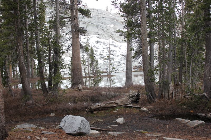
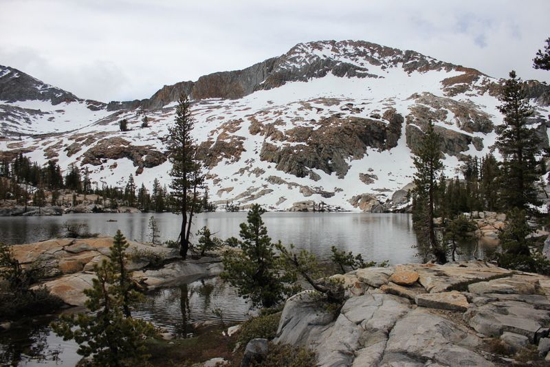
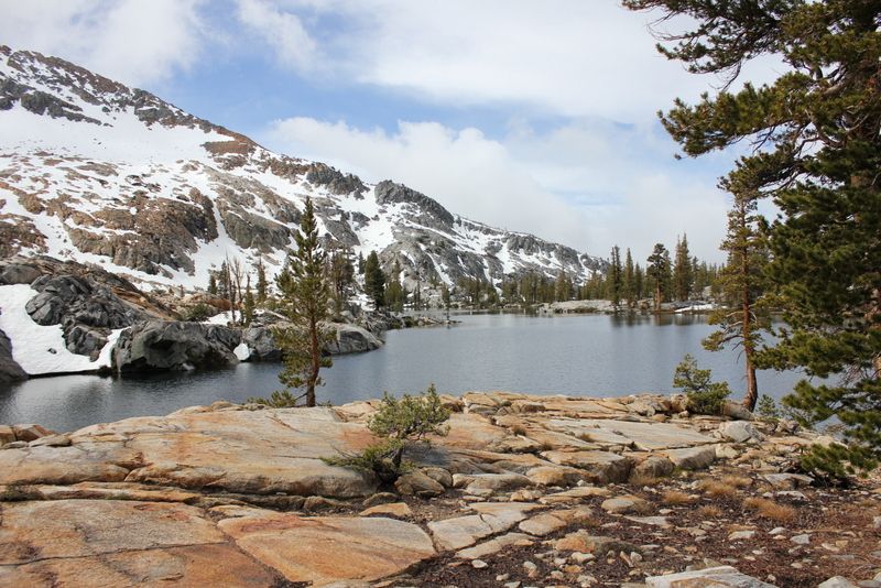
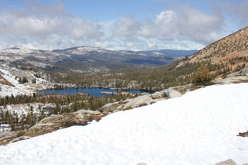
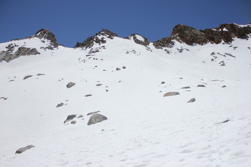
I should have kept going! I was rained on all night long. I’ve had the Eureka Spitfire 1 tent for many years, but never in the rain. It worked fantastically. It kept me and all of my gear dry and comfortable—though it was only a light rain. The second day, I woke up and packed quickly during a lull in the rain, and began hiking at 7:30 AM. This portion of the trail was very neat, and with the weather it felt as though I was hiking through a rain forest. This is also where there started to be snow cover due to the thick forest shading the forest floor. The snow patched continued up until the climb between Lower Ottaway and Upper Ottaway Lakes where it became consistent and thick coverage. From what I could see, the upper lakes were completely frozen.
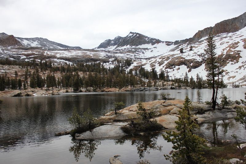
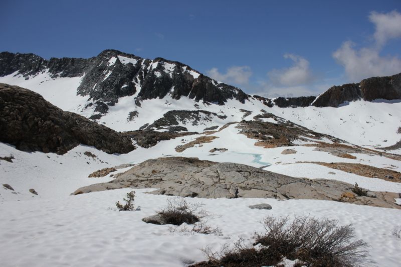
Just before I reached the lakes, the cloud coverage cleared, and I was able to see the peaks and the surrounding mountain ranges for the first time. This made the ascent from Lower Ottoway to Red Peak Pass very enjoyable. As I was alone, I hiked very slowly consistently being aware of my breathing, and how my body was reacting to the altitude—but thankfully didn’t have any problems. The switchbacks that lead to the top of RPP were all snow-free, though the approach blanketed. I apologize to anyone who followed my tracks because I missed the trail by about 50 yards and had to backtrack down to where the switchbacks started.
The descent was slow going. I brought Khatoolas, but the conditions didn’t call for them. The snow was compact enough that I wasn’t postholing—only sinking in a couple of inches or so each step—and soft enough that I wasn’t losing grip.
The snow was consistent until just before Merced Peak Fork, or so. Merced Peak Fork was an entwined system of creeks that would join together and then split again forming a maze of fast moving, rocky creeks. I ended up hiking up stream until I was able to cross four separate water flows without getting wet. From here the trail enters the forest once again and it was an enjoyable slight descent into Triple Peak Fork where I spent my second night.
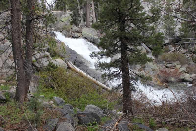
Day three also started in rain. This rain I wasn’t expecting, but it also wasn’t terribly strong either. The hike along Triple Peak Fork was a gradual decline, and very enjoyable. On the right you have the river that would occasionally be roaring over some rapids, or down a series of falls and to the left exposed granite. There is one steep decline as you descend next to a waterfall, and just before you cross the Merced Peak Fork. The switchbacks were long, and the sun had started to win the battle with the clouds.
The blowdowns just before Washburn had been completely taken care of. They were all clean-cut and didn’t provide any problems—though there was a warning sign on the bridge crossing the river that it was closed. Of course the sign was only on one side of the bridge, and not the side I entered.

One of my favorite parts of the trail was just after Washburn Lake where the trail follows along the river on cliff. Once back in the forest, the mosquitos were out. I stopped to filter water at Merced Lake Ranger Station, where the trail branches to Tuolumne, and I was swarmed. Merced Lake High Sierra Camp was empty, and all of the temporary tent shelters were not yet constructed.
My original plan was to stay they night here, but it was only 2:00, so I decided to hike into Little Yosemite Valley. I took the Bunnell Point trail, and it was here that I began to see people again (last people I had seen were on the Panorama Trail on Monday). I made it to LYV at 7:30 PM. It was crowded so I went to bed early, and got up early to close my hike out by taking the Panorama trail back to GP and driving home to San Diego.
At 10:30 AM I started on the Panorama Trail towards Nevada Falls. Almost to the top of the switchbacks and where the trail follows the contour of the Panorama Cliff I was asked to take a picture for a solo female hiker. I found out that she started her hike at Happy Isles and thought she was on the trail to Half Dome (she was headed down to Illilouete Creek)—in jeans and only one small bottle of water, and no other gear to speak of.
From the Panorama Trail I took the high trail around Mt. Starr King. This was an enjoyable trail that was relatively level and provided some nice views of the granite domes. At the junction, where the trail that starts at Mono Meadow merges, the trail began to gradually climb along the river. At this point, the afternoon clouds rolled in and I was greeted with rain. I knew rain was in the forecast, and I was told by two separate rangers that the snow line would be down to 8000’ by one and to 8900’ by the other. I would much rather have snow, so I made it a point to get to above 8900’ for camp. To avoid we gear I put my Gregory rain cover on my pack, and a large poncho over myself, and partially over the top of my pack to thwart water from soaking into my pack between my back and my pack. At 7:00 I reached Lower Merced Pass Lake where I made camp.
I should have kept going! I was rained on all night long. I’ve had the Eureka Spitfire 1 tent for many years, but never in the rain. It worked fantastically. It kept me and all of my gear dry and comfortable—though it was only a light rain. The second day, I woke up and packed quickly during a lull in the rain, and began hiking at 7:30 AM. This portion of the trail was very neat, and with the weather it felt as though I was hiking through a rain forest. This is also where there started to be snow cover due to the thick forest shading the forest floor. The snow patched continued up until the climb between Lower Ottaway and Upper Ottaway Lakes where it became consistent and thick coverage. From what I could see, the upper lakes were completely frozen.
Just before I reached the lakes, the cloud coverage cleared, and I was able to see the peaks and the surrounding mountain ranges for the first time. This made the ascent from Lower Ottoway to Red Peak Pass very enjoyable. As I was alone, I hiked very slowly consistently being aware of my breathing, and how my body was reacting to the altitude—but thankfully didn’t have any problems. The switchbacks that lead to the top of RPP were all snow-free, though the approach blanketed. I apologize to anyone who followed my tracks because I missed the trail by about 50 yards and had to backtrack down to where the switchbacks started.
The descent was slow going. I brought Khatoolas, but the conditions didn’t call for them. The snow was compact enough that I wasn’t postholing—only sinking in a couple of inches or so each step—and soft enough that I wasn’t losing grip.
The snow was consistent until just before Merced Peak Fork, or so. Merced Peak Fork was an entwined system of creeks that would join together and then split again forming a maze of fast moving, rocky creeks. I ended up hiking up stream until I was able to cross four separate water flows without getting wet. From here the trail enters the forest once again and it was an enjoyable slight descent into Triple Peak Fork where I spent my second night.
Day three also started in rain. This rain I wasn’t expecting, but it also wasn’t terribly strong either. The hike along Triple Peak Fork was a gradual decline, and very enjoyable. On the right you have the river that would occasionally be roaring over some rapids, or down a series of falls and to the left exposed granite. There is one steep decline as you descend next to a waterfall, and just before you cross the Merced Peak Fork. The switchbacks were long, and the sun had started to win the battle with the clouds.
The blowdowns just before Washburn had been completely taken care of. They were all clean-cut and didn’t provide any problems—though there was a warning sign on the bridge crossing the river that it was closed. Of course the sign was only on one side of the bridge, and not the side I entered.
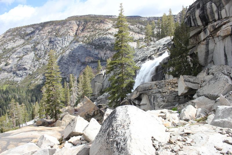
One of my favorite parts of the trail was just after Washburn Lake where the trail follows along the river on cliff. Once back in the forest, the mosquitos were out. I stopped to filter water at Merced Lake Ranger Station, where the trail branches to Tuolumne, and I was swarmed. Merced Lake High Sierra Camp was empty, and all of the temporary tent shelters were not yet constructed.
My original plan was to stay they night here, but it was only 2:00, so I decided to hike into Little Yosemite Valley. I took the Bunnell Point trail, and it was here that I began to see people again (last people I had seen were on the Panorama Trail on Monday). I made it to LYV at 7:30 PM. It was crowded so I went to bed early, and got up early to close my hike out by taking the Panorama trail back to GP and driving home to San Diego.
June 02, 2013 02:29PM | Registered: 13 years ago Posts: 1,351 |
June 02, 2013 05:19PM | Moderator Registered: 14 years ago Posts: 7,421 |
Kewl. Tanks for saying wutt ya did.
If interested... you can peek here:
https://picasaweb.google.com/yosemite.chick.on/SnowCrkEchoHappyIsleLoopWashburn
Towards the end is Triple Peak Fork and Washburn/Merced... gives you a comparison
from 2 years ago in mid June to now. (I find the Washburn ones themselves particularly
enlightening)
One spot that I truly enjoyed and really want to get back out and hang out by is a bit south of
Red Peak Fork. Lots of nice trees and nice and open.
|
Re: Red Peak Pass in Late May June 03, 2013 02:28PM | Registered: 11 years ago Posts: 16 |
|
Re: Red Peak Pass in Late May June 03, 2013 05:23PM | Registered: 12 years ago Posts: 129 |
June 05, 2013 07:40AM | Moderator Registered: 14 years ago Posts: 7,421 |
|
Re: Red Peak Pass in Late May June 07, 2013 07:32AM | Registered: 11 years ago Posts: 16 |
OK, I'm pleading for leniency. After a 9-day trip and about 1,000 pictures and a bunch of videos, I was greeted by complete insanity upon returning home earlier this week. I realize my moral obligation to this community after all of the great information I received from everyone. I know our trip was waaaaay more amazing than it would have otherwise been because of everyone's input and trail reports from others. Long nights at the office and preparing for a graduation party have delayed me, but I will report back this weekend. Pinky swear.
And Torero, thanks so much for the bug spray. That was really awesome. Since we were mostly staying up high I thought we'd be OK, but that stretch just before we ran into you and a few miles after that the bugs were crazy.
My daughter was so thankful you shared. When we stopped a mile or so up the trail she said it was like she had a forcefield around her. She'd see the bugs fly toward her arm and then veer off an inch or two away. She was already hurting a bit at that point, so I greatly appreciate you rescuing her from the bugs.
|
Re: Red Peak Pass in Late May June 06, 2013 08:42PM | Registered: 11 years ago Posts: 196 |
|
Re: Red Peak Pass in Late May May 20, 2013 11:57AM | Registered: 12 years ago Posts: 129 |
Thank you all for the responses. The recommendations, trip reports, and photos have been helpful in molding my trip, and preparing the proper gear. Based on the advice, I am going to start at Glacier Point, taking the Panorama Cliff Trail across the Illilouette drainage, and onto the upper trail that Circles Mt. Starr King towards the Clark Range. Based on my calculations, day one will be just over 15 miles to the trail junction at Upper Merced Pass Lake. Reaching Upper or Lower Merced Pass Lake might be asking too much starting around noon. Any suggestions on intermediate camp sites?
Also—I agree that the snowshoes will be excess gear if the snow has consolidated. In that case, I will bring my Kahtoolas. If anyone has conflicting reports of the snow condition in that area please let me know. Also- there is a chance of rain on the day I would be crossing the pass. Does anyone know how that might affect the snow conditions? I’m guessing if it rains in that area, it would create hard, slick ice making more need for traction but less need for snowshoes?
Also—I agree that the snowshoes will be excess gear if the snow has consolidated. In that case, I will bring my Kahtoolas. If anyone has conflicting reports of the snow condition in that area please let me know. Also- there is a chance of rain on the day I would be crossing the pass. Does anyone know how that might affect the snow conditions? I’m guessing if it rains in that area, it would create hard, slick ice making more need for traction but less need for snowshoes?
|
Re: Red Peak Pass in Late May May 20, 2013 07:06PM | Registered: 12 years ago Posts: 140 |
May 21, 2013 11:01AM | Registered: 13 years ago Posts: 36 |
June 03, 2013 09:13AM | Registered: 11 years ago Posts: 308 |
|
Re: Red Peak Pass in Late May June 09, 2013 12:44PM | Registered: 10 years ago Posts: 11 |
Thank you thank you thank you!
Great photos that show conditions very well and appreciate the write up as well. I agree with another in that you are braver than I to want to seek out that area knowing of snow/rain this early in the season! Glad to hear you are back safe and your condition descriptions will help me fit in Washburn (one of my favorites) to my 8 day loop via the RPP.
Great photos that show conditions very well and appreciate the write up as well. I agree with another in that you are braver than I to want to seek out that area knowing of snow/rain this early in the season! Glad to hear you are back safe and your condition descriptions will help me fit in Washburn (one of my favorites) to my 8 day loop via the RPP.
Sorry, only registered users may post in this forum.

