issued by CLIMATE PREDICTION CENTER/NCEP
10 February 2011
ENSO Alert System Status: La Niña Advisory
Synopsis: ENSO-Neutral or La Niña conditions are equally likely during May-June 2011
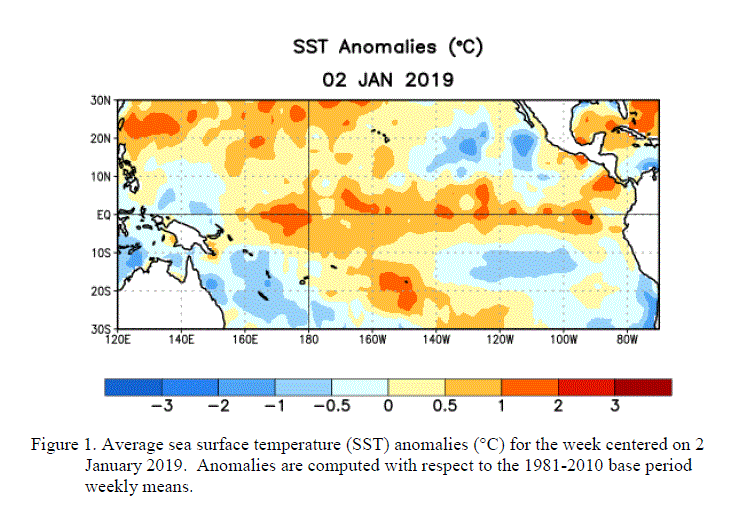
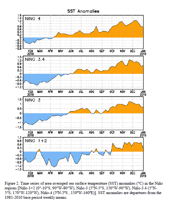
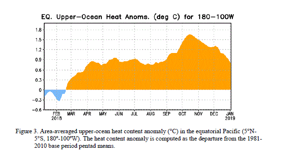
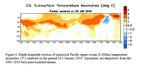
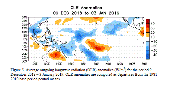
La Niña persisted during January 2011 as reflected by well below-average sea surface temperatures (SSTs) across much of the equatorial Pacific Ocean (Fig. 1). However, some weakening was evident in certain atmospheric and oceanic anomalies, in part due to Madden-Julian Oscillation activity. Most Niño indices were between –1oC and –1.5oC at the end of January, with the easternmost Niño-1+2 region returning to near-average (Fig. 2). A lessening of the negative subsurface oceanic heat content anomalies (average temperatures in the upper 300m of the ocean, Fig. 3) was observed mostly in association with an eastward shift in the above-average temperatures at depth in the central equatorial Pacific (Fig. 4). Convection remained enhanced over Indonesia and suppressed over the western and central equatorial Pacific (Fig. 5). Also over the western and central equatorial Pacific, the anomalous low-level easterly and upper-level westerly winds decreased in magnitude. Collectively, these oceanic and atmospheric anomalies reflect an ongoing, mature La Niña that has begun to weaken.
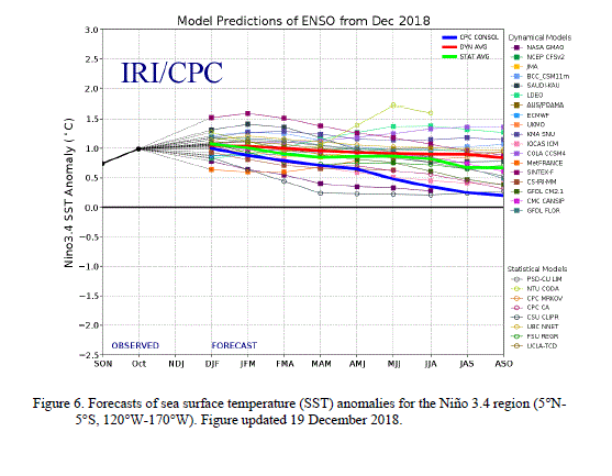
Nearly all of the ENSO model forecasts weaken La Niña in the coming months (Fig. 6). A majority of the models predict a return to ENSO-neutral conditions by May-June-July 2011, although some models persist a weaker La Niña into the Northern Hemisphere summer 2011. Recent trends in the observations and models do not offer many hints on which outcome is more likely. Also, model skill is historically at a minimum during the Northern Hemisphere spring (the “spring barrier”). Therefore La Niña is expected to weaken during the next several months, with ENSO-neutral or La Niña conditions equally likely during May-June 2011.
Expected La Niña impacts during February-April 2011 include suppressed convection over the west-central tropical Pacific Ocean, and enhanced convection over Indonesia. Potential impacts in the United States include an enhanced chance of above-average precipitation in the Northern Rockies and western regions of the Northern Plains (along with a concomitant increase in snowfall), Great Lakes, and Ohio Valley. Below-average precipitation is favored across much of the southern states. An increased chance of below-average temperatures is predicted for much of the West Coast and northern tier of states (excluding New England), and a higher possibility of above-average temperatures is forecast for much of the southern and central U.S. (see 3-month seasonal outlook released on January 20th, 2011).
This discussion is a consolidated effort of the National Oceanic and Atmospheric Administration (NOAA), NOAA's National Weather Service, and their funded institutions. Oceanic and atmospheric conditions are updated weekly on the Climate Prediction Center web site (El Niño/La Niña Current Conditions and Expert Discussions). Forecasts for the evolution of El Niño/La Niña are updated monthly in the Forecast Forum section of CPC's Climate Diagnostics Bulletin. The next ENSO Diagnostics Discussion is scheduled for 10 March 2011. To receive an e-mail notification when the monthly ENSO Diagnostic Discussions are released, please send an e-mail message to: ncep.list.enso-update@noaa.gov.
