Welcome! Log In Create A New Profile Recent Posts
Deer in Yosemite

The Moon is Waxing Gibbous (82% of Full)


Advanced

Grand Canyon National Park Implements New Temporary Road and Trail Closures on the North Rim; Obi Fire Grows to 8,100 Acres

All posts are those of the individual authors and the owner of this site does not endorse them. Content should be considered opinion and not fact until verified independently.

avatar Grand Canyon National Park Suppressing Three Fires on North Rim
July 26, 2018 11:28AM

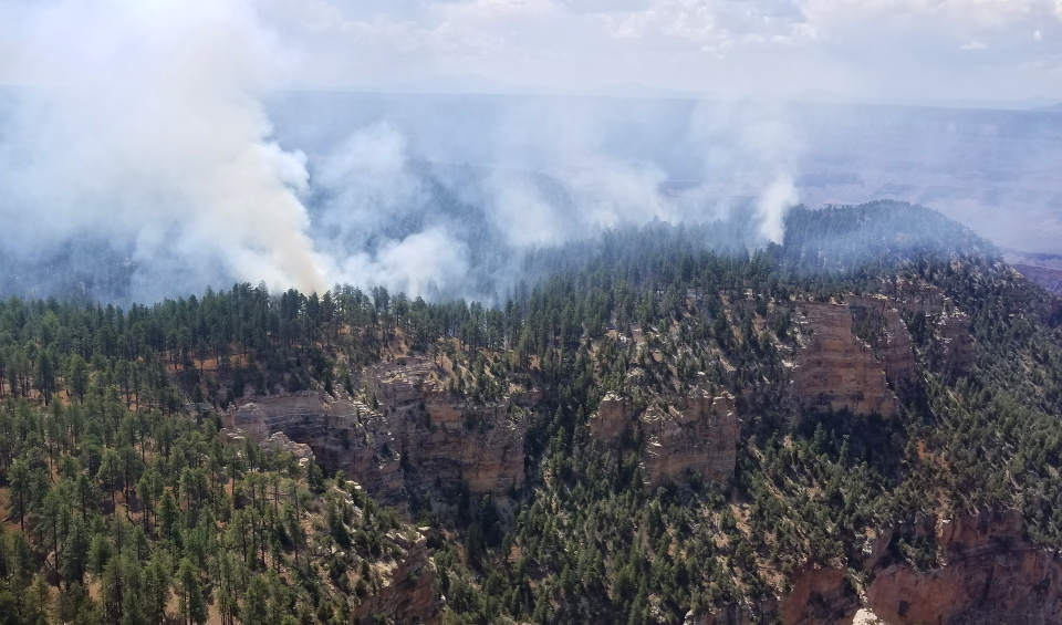
Smoke from fires on the North Rim on July 24, 2018 - NPS photo

Grand Canyon, AZ- Recent monsoonal activity in the region resulted in an several new lightning ignited fires on the North Rim of Grand Canyon National Park over the past several days. Fire crews are actively working to suppress three fires within Grand Canyon National Park.

The Saffron Fire, located between Fire Point and Swamp Point is being directly suppressed. Fire crews are working to contain the fire at the smallest possible size by digging handline around the fire's perimeter. This fire started in the southwest corner of the North Kaibab Ranger District late last week and is now burning within Grand Canyon National Park. It is currently estimated to be 30 acres and backing and flanking in ponderosa pine forest..

Fire crews are also directly suppressing the Atoko Fire, detected on July 22nd, on the east side of Cape Royal Road, near Atoko Point. Approximately 20 acres in size, current fire behavior is creeping and smoldering within ponderosa pine and brush fuels.

The Obi Fire was detected on July 21st and is located in the far southwest corner of the Wahalla Plateau above Obi Point. It is approximately 40 acres in size and burning in ponderosa pine and brush. Fire managers plan to confine and contain the Obi Fire to a defined planning area while providing for point protection of identified sensitive natural and cultural resources. More information about the Obi Fire may be found on InciWeb: https://inciweb.nwcg.gov/incident/6030/

The Imperial Fire, located along the Cape Royal Road near Vista Encantada, has been contained at 1.5 acres.

Smoke is visible from both the North and South Rims of the park. At this time there are no road closures, individuals driving along Cape Royal Road should be aware of fire crews working in the vicinity. Motorist should turn on their headlights and slow down for emergency response vehicles.

Grand Canyon National Park is receiving interagency support with a Type 2IA handcrew, local resources from the North Zone Interagency Fire Management Organization, and from the South Rim of the park.

Each fire start is evaluated by fire management officials for the most appropriate management strategy. Firefighter safety, resources at risk, location of the fire, available resources, regional and national preparedness levels, and weather forecast are taken into consideration when responding to a wildfire ignition.

Please visit https://www.nps.gov/grca/learn/management/firemanagement.htm for additional information about wildland fire at Grand Canyon National Park. To learn more about current fires in the region and across the country, visit http://www.inciweb.nwcg.gov .
Grand Canyon, AZ - Grand Canyon National Park has implemented new temporary closures for public and firefighter safety. These include the Swamp Ridge Road, the North Bass Trail, and the Powell Plateau Trail. Fire Point, the Nankoweap Trail, and the Point Imperial Trail remain closed. Grand Canyon National Park has also closed Cape Royal Road from the junction with the Point Imperial Road. Included in this closure are Cape Final Trail, Cliff Spring Trail, the northern section of the Ken Patrick Trail from Point Imperial to Cape Royal Road, and the southern section of the Ken Patrick Trail from Cape Royal Road to the old Bright Angel Trail. The temporary closures are in effect until further notice. The road to Point Imperial and all other North Rim trails and facilities are open at this time. Prior to visiting these areas visitors should check-in at the Backcountry Information Center or the North Rim Visitor Center.

The Obi Fire is estimated at 8,100 acres. Growth today was primarily in the southern and eastern portions of the fire perimeter as the fire continues to back down towards Cape Royal. Fire behavior was active with isolated tree torching and surface fire of two to four foot flames where the fire was consuming dead logs. The fire continues to grow through pine needles and downed logs.

Smoke from the Obi Fire is visible from both the North and South Rims of the park. Smoke will become more visible to the south and southeast as the fire progresses further down the Walhalla Plateau. There is also visible smoke being produced by fires on the Kaibab National Forest. Visitors may see increased smoke or haze filling the canyon. For more information about air quality at Grand Canyon National Park visit, https://www.airnow.gov/index.cfm?action=airnow.local_city&cityid=31 .

Resources assigned to the fire include one Type 2IA handcrew, three engines, one helicopter, one helitack crew, and a fire ecologist.

Please visit https://www.nps.gov/grca/learn/management/firemanagement.htm for other information about wildland fire at Grand Canyon National Park or call +1 928 638-7819 for recorded fire information. For additional daily updates and photos visit the Obi Fire Inciweb incident page at https://inciweb.nwcg.gov/incident/6030/.
Sorry, only registered users may post in this forum.

Click here to login