Jay Robinson
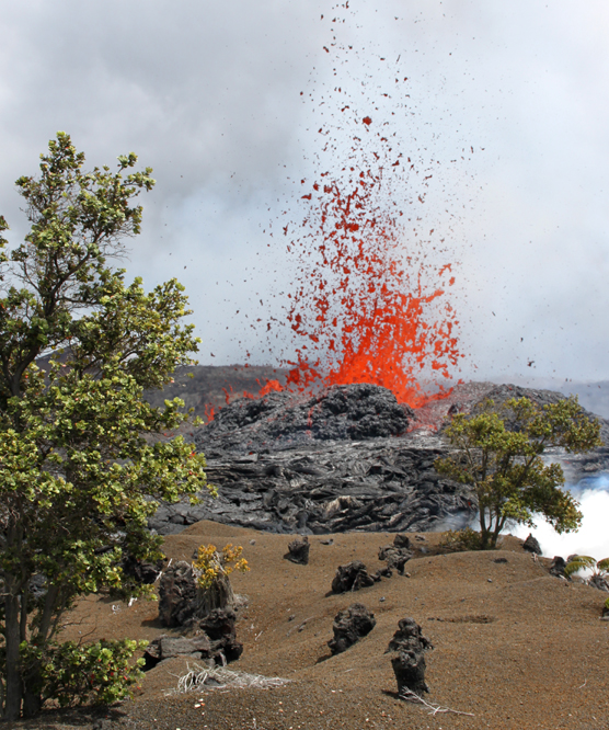
Lava spatters from a new fissure that broke open in a field of tephra.
The eruption that began on March 5, 2011, continues on the east rift of Kilauea Volcano.
Lava spatters sporadically to average heights of 65' from a series of fissues that extend more than a mile between Napau Crater and Pu`u `O`o. Aound the vents, molten rock puddles and hardens.
In response to the change in volcanic conditions, nearly thirty park personnel have rallied to support this major incident, meeting and planning for the first time in the park's new Visitor Emergency Operations Center.
Rangers remain vigilant. Seismicity is ongoing, the volcano's summit continues to deflate, and magma migrates underground beneath roads, trails, and a campsite on the volcanoe's east rift.
Hawai`i Volanoes closed Chain of Craters Road and all east rift and coastal trails, along with Kulanaokuaiki Campground, until further notice. The closure helps ensure that hikers and cars don't get trapped on the 'wrong side' of an outbreak.
USGS Hawaiian Volcano Observatory scientists seize this oportunity to measure gas emissions and surface deformation, collect lava and fallout, and map the ever-changing landscape.
Park firefighters gauge the threat of lava-ignited wildfires. Fortunately for now, drenching rains offer a reprieve from potential flare-ups in the surrounding native `ohi`a-hapu`u rain forest.
Public and media interest is keen and visitation is up. The park and its most popular overlooks and summit trails remain open. However, because the new eruption is remote and inaccessible, rangers share the latest information, photos, and videos at Kilauea Visitor Center and Jaggar Museum. A webcam view is available on-line at http://volcanoes.usgs.gov/hvo/cams/NCcam/
It's a phenomenal time, and for some, deja vu. The volcanic event is located where it all vegan twenty-eight years ago. On January 3, 1983, Kilauea's ongoing east rift eruption oprned in this very spot. Newcomers can't help but wonder "What happens next?" Old-timers take time to pause and ponder, and offer an occasional "I remember when... "


