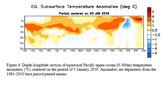
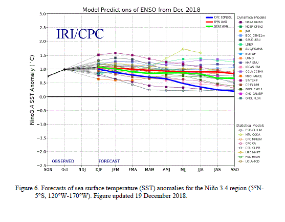
A majority of models predict La Niña to weaken through the rest of the Northern Hemisphere winter 2011-12, and then to dissipate during the spring 2012 (Fig. 6). Also, there is evidence of a downwelling phase of an eastward-propagating oceanic Kelvin wave (red shading, Fig. 4), which may increase temperatures across the Pacific in the next couple of months. The combination of a weakening subsurface temperature anomaly, the historical seasonal evolution, and forecaster preference for the average dynamical model prediction favors a return to ENSO-neutral conditions during the Northern Hemisphere spring, which are likely to continue into the summer. Therefore La Niña is likely to transition to ENSO-neutral conditions during March-May 2012 (see CPC/IRI consensus forecast).
Because the strength of impacts in the United States is not necessarily related to the exact strength of La Niña in the tropical Pacific, we expect La Niña impacts to continue even as the episode weakens. Over the U.S. during February - April 2012, there is an increased chance of above-average temperatures across the south-central and southeastern U.S., and below-average temperatures in the northwestern U.S. Also, above-average precipitation is favored across most of the northern tier of states (except the north-central U.S.) and in the Ohio and Tennessee Valleys, and drier-than-average conditions are more likely across the southern tier of the U.S. (see 3-month seasonal outlook released on 19 January 2012).
This discussion is a consolidated effort of the National Oceanic and Atmospheric Administration (NOAA), NOAA's National Weather Service, and their funded institutions. Oceanic and atmospheric conditions are updated weekly on the Climate Prediction Center web site (El Niño/La Niña Current Conditions and Expert Discussions). Forecasts for the evolution of El Niño/La Niña are updated monthly in the Forecast Forum section of CPC's Climate Diagnostics Bulletin. The next ENSO Diagnostics Discussion is scheduled for 8 March 2012. To receive an e-mail notification when the monthly ENSO Diagnostic Discussions are released, please send an e-mail message to: ncep.list.enso-update@noaa.gov.
