All posts are those of the individual authors and the owner of this site does not endorse them. Content should be considered opinion and not fact until verified independently.

Pinnacles NP
January 01, 2013 08:03AM
In one of the less publicized developments in Washington over the past week, the Senate unanimously (!) passed legislation to make the Pinnacles a National Park. The bill only needs the signature of President Obama, which should be a formality, to go into effect.


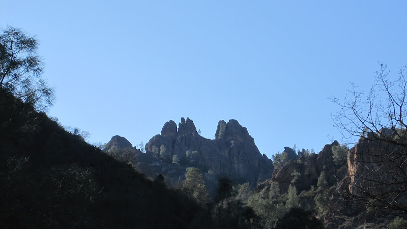
Since I grew up quite near the Pinnacles, this spot holds a special place in my heart---and I heartily recommend that you visit it. An amazing place with wonderful hikes. I particularly remember one hike during my college years when I reached the top of the crest to see the clouds all beneath me--and a clear shot to the Sierra towering over the far side of the Central Valley. And then the wind began to blow...and the clouds below began to send tiny snowflakes up the cliff and into my face. Yes, it was snowing uphill.

That was also the trip I hiked the caves trail without a flashlight. Pitch black, with a swiftly running creek, deep crevices, and low overhangs. Quite the adventure. Not recommended!


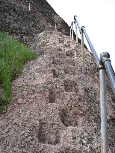
The trails here do involve a little more exposure and effort than in most parks

What a great way to start the New Year!


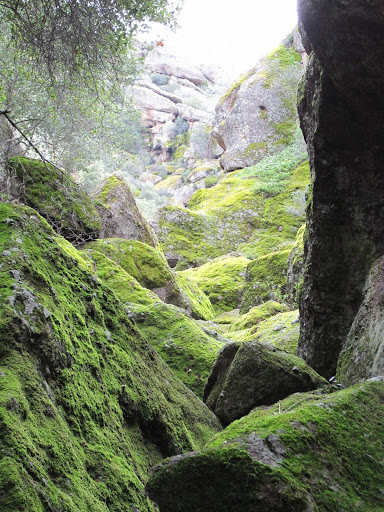
The photos here capture only a part of the charm of this area. And while the summer can be brutally hot, the spring brings lush growth to the canyons and stunning wildflowers.


Check our our website: http://www.backpackthesierra.com/
Or just read a good mystery novel set in the Sierra; https://www.amazon.com/Danger-Falling-Rocks-Paul-Wagner/dp/0984884963
avatar Re: Pinnacles NP
January 02, 2013 07:36AM
Wondering if The Sierra Nevada can indeed be seen from Pinnacles.
Two winters ago we went there and climbed N. Chalone and High Peaks
and it was a crystal clear day. Was quite a bit bummed could not make
out the Snowy Range. Visibility was excellent so concluded just cannot
see Sierra from there. On top of N. Chalone there is a plaque that talks
about air quality and it doesn't mention Sierra.

Curious

Pinnacles is a great little Park. Well worth a visit or two.


Chick-on is looking at you!
Re: Pinnacles NP
January 02, 2013 10:39AM
Try it in winter, forty years ago.

OK, maybe that won't be possible. It would be sad if the air quality in our state has now made that view a thing of the past. As per some of the other threads in here...it is possible from Patterson and Lick Observatory. And as I noted, I was possible forty years ago....sigh


Check our our website: http://www.backpackthesierra.com/
Or just read a good mystery novel set in the Sierra; https://www.amazon.com/Danger-Falling-Rocks-Paul-Wagner/dp/0984884963
avatar Re: Pinnacles NP
January 02, 2013 07:55PM
If anything, I think the air quality from Pinnacles has improved considerably from the first time I visited in the late 1980s. The Bay Area's pollution is channeled down the Gabilan Valley on the east side, and I know air quality is much better here now than it was then, its now generally clear that the Bay Area is a valley, wasn't always so then.
Re: Pinnacles NP
January 02, 2013 11:53AM
The skyline East to N-E of Chalone Peak (about 3300') is pretty much blocked by peaks and ridges from 3300' to 3900' that would block the Sierra. There may be gaps to peek through though. A quick browse on GoogleEarth didn't look promising.
avatar Re: Pinnacles NP
January 02, 2013 01:42PM
Yes. This is exactly what I observed. Maybe I will post a photo or two including the sign.
The air quality was definitely good enough that The Sierra should have been able to be seen
if it was possible. Again, this is just what I observed. Perhaps it was too hazy but I just don't think so.

From the top of Mt. Hamilton or Mt. Diablo The Sierra is easily seen. That is a different realm.

For the webcam lovers out there... there is a cam atop Mt. Hamliton:
http://mthamilton.ucolick.org/hamcam/

The Sierra is in this view:
http://mthamilton.ucolick.org/hamcam/hamcam2.html


Chick-on is looking at you!
avatar Re: Pinnacles NP
January 02, 2013 06:20PM
heywhatsthat.com confirms that:

(a.) You can't see any part of the Sierra Nevada from the peak (3200'+) in Pinnacles Nat. Mon./Park that I tried.


(b.) You can't see any part of the Pinnacles from Half Dome.


(c.) You can see many points in the SN, including parts of Half Dome and Sentinel Dome, from Mt. Hamilton.

Click on the links above to go to the respective maps. Click the [Visibility Cloak] button, zoom out, and see what you can and can't see from each viewpoint. I created a couple of those views but I'm assuming they'll be accessible to everyone now. If anyone gets different results from some other peak in the Pinnacles, by all means create your own heywhatsthat view and send us a link.


Edited 1 time(s). Last edit at 01/02/2013 06:23PM by gophersnake.
Re: Pinnacles NP
January 02, 2013 06:35PM
hmmm. From what I remember, we were on top of Chalone Peak at the fire lookout, and were looking east across the Central Valley at snow capped peaks. So were we seeing another part of the Coast Range? Or was the dope we were smoking bending the light that much?

hey. it was 40 years ago, and we were in college...


Check our our website: http://www.backpackthesierra.com/
Or just read a good mystery novel set in the Sierra; https://www.amazon.com/Danger-Falling-Rocks-Paul-Wagner/dp/0984884963
avatar Re: Pinnacles NP
January 02, 2013 09:49PM
Wasn't trying to give you a hard time. Almost certainly it was another part of the coast range.
Was quite bummed as I already mentioned that couldn't see Sierra.

Here's the sign at N. Chalone:


and the view(s)


Prob. when you were there the last photo ... the furthest range there... prob. had snow on it.

Have fun


Chick-on is looking at you!
Re: Pinnacles NP
January 03, 2013 09:52AM
You must be right...photos don't lie. Still a wonderful view.


Check our our website: http://www.backpackthesierra.com/
Or just read a good mystery novel set in the Sierra; https://www.amazon.com/Danger-Falling-Rocks-Paul-Wagner/dp/0984884963
avatar Re: Pinnacles NP
January 04, 2013 09:57AM
Quote
chick-on
Wasn't trying to give you a hard time. Almost certainly it was another part of the coast range.
Was quite bummed as I already mentioned that couldn't see Sierra.

Here's the sign at N. Chalone:


According to this sign, on a clear day one can see 218 miles to the east of N. Chalone Peak. Wouldn't that be somewhere in the Sierra, maybe slightly south of Mt. Whitney?

And according to heywhatsthat.com, one can see McPhails Peak due west on the horizon from Mt. Whitney. McPhails Peak is on the same coastal range as N. Chalone Peak, about 12 miles to the northwest of N. Chalone.

But according to heywhatsthat.com, the view of Mt. Whitney itself from N. Chalone Peak appears to be block by Rock Spring Peak and Lookout Peak located to the east of N. Chalone Peak.
avatar Re: Pinnacles NP
January 04, 2013 11:38AM
I hear you. I know it says >200 miles. But it doesn't say Sierra.
You would think it would.
And on the particular day I was up there the visibility was just stellar...
there was loads of snow in the Sierra... and on top of both High Peaks
and N. Chalone... couldn't see any snow at all. Was quite bummed.
Was telling the wife it was gonna be so cool since we should be able
to see the Sierra... got to the top... dangitall!
So I was wondering if it was indeed possible. I didn't think it was.
And from the links from gophersnake I am convinced it's not.


Chick-on is looking at you!
avatar Re: Pinnacles NP
January 04, 2013 03:35PM
Quote
plawrence
According to this sign, on a clear day one can see 218 miles to the east of N. Chalone Peak. Wouldn't that be somewhere in the Sierra, maybe slightly south of Mt. Whitney?

There seems to be something fishy about that statistic, or else I'm misunderstanding it. From North Challone, a 218-mile-long line at azimuth 090 (true) passes about 12 miles south of Mt. Whitney and ends over a canyon in an area where the highest nearby peaks aren't much over 4000'. That's according to my TOPO! digital map. Maybe they were talking about generic "east", anywhere between northeast and southeast, and some hypothetical target like a hundred-foot black-and-white balloon that we could see up to 218 miles away if it were above our horizon. The 218-mile figure could've been calculated from strictly local measurements like how much a laser beam was being scattered by the haze in the air.

The heywhatsthat view from Mt Whitney (with Visibility cloak switched on) does show a few red splotches about 15 miles NW of The Pinnacles but nothing at all within the park.
avatar Re: Pinnacles NP
January 04, 2013 04:35PM
Yes, that's what I pointed out when I mentioned that it appeared to be visible from McPhails Peak.

According to the visibility cloak generated by heywhatsthere.com, one can actually spot Mt. Whitney from spots inside Henry W. Coe and Pacheco State Parks, which I think is kinda cool.

.
avatar Re: Pinnacles NP
January 04, 2013 05:37PM
Quote
gophersnake

The heywhatsthat view from Mt Whitney (with Visibility cloak switched on) does show a few red splotches about 15 miles NW of The Pinnacles but nothing at all within the park.


If the Visibility Cloak of heywhatsthat.com is to be belived, on a clear day one should be able to spot THE TOP of Half Dome (but not its entire face) as far west as San Ramon in the Bay Area.

According to its Visibility Cloak, the top of Half Dome can be spotted at the intersection of San Ramon Valley Blvd and Bollinger Canyon Road next to I-680 in San Ramon. Ironically, the top of Half Dome IS NOT visible from the summit of Mt. Diablo, according to heywhatsthat.com.

Go figure...

.
avatar Re: Pinnacles NP
January 04, 2013 05:50PM
Having more fun with the Visibility Cloak of heywhatsthat.com, the top of Mt. Ritter should be visible on a clear day from the eastern slope of Loma Prieta and even the part of eastern slope of Mt. Thayer just south of San Jose.

It also should be visible on the clearest of days just off of Hollis Canyon Road in Dublin Hills Regional Park northeast of Dublin.
.
avatar Re: Pinnacles NP
January 04, 2013 06:41PM
And according to the Visibility Cloak, the summit of Mt. Goddard could be visible from the jct. of Glenwood Drive and Hwy 17 in the Santa Cruz Mountains, over 179 miles away!

.
avatar Re: Pinnacles NP
January 07, 2013 12:49PM


If anyone is interested on more photos taken by the Park Service from this vista at Pinacles, an archive of them are located here:

http://vista.cira.colostate.edu/Datawarehouse/IMPROVE/Data/Photos/PINN/start.htm

.
avatar Re: Pinnacles NP
January 04, 2013 08:17AM
I really don't agree with this re-designation. It just doesn't make any sense to me. I know that Sam Farr is pushing it because he feels it will bring in higher visitation, but I really don't see many people visiting Pinnacles who wouldn't have otherwise done do. Re-designation didn't improve visitation at Death Valley (which already had a reputation) or do much at Congaree.

Pinnacles doesn't seem to have the resources that I would expect from a "National Park".
Sorry, only registered users may post in this forum.

Click here to login