All posts are those of the individual authors and the owner of this site does not endorse them. Content should be considered opinion and not fact until verified independently.

avatar Google satellite views and Street View
January 11, 2016 04:07PM
I noticed recently that Google Earth now includes "street views" from several popular trails around Yosemite Valley -- I noticed the Four Mile, the John Muir, and the Upper Yosemite Falls Trail but I think there are more. It looks like they sent someone up those trails with a Google cam on their back. It's kind of cool but beware of the GPS readouts and calculations in the bottom right corner. When I've compared the latitude-longitude and elevation data with the best info I have, Google's is not only wildly off a lot of the time, but often inconsistent. In a few places their cam carrier advances 100 feet along a trail that climbs steadily through that whole area -- and the altitude readout drops by something like10 feet. tongue sticking out smiley That's probably due in part to the difficulty of getting good GPS readings around cliff walls and tree cover, but I also get the feeling that Google is sometimes pretty sloppy with their mapping. Overextended with new projects, maybe. They've been showing the Four Mile trail on their maps as a wiggly line with fewer than 20 switchbacks. eye rolling smiley The real thing has 59.

If Google has added street views of trails to Google Maps as well as Google Earth, the same data are probably being used for both. Someone asked in another thread:

Quote
buster
Google Streetview (First time I've used the trail street view option of google maps. Kind of odd but useful in this case. Also, anyone else notice and get annoyed with how google maps is now try to display trees in 3d formats on it's satellite imagery? It looks really weird, is distracting, not helpful at all and makes it harder to look at the imagines)

I use Gmap4 to access Google Maps. Years ago someone posted a link to a "Howson Creek Trail" map that I recentered on Yosemite Valley (or maybe they did). I've been using it ever since:
http://www.mappingsupport.com/p/gmap4.php?q=http://www.mappingsupport.com/p/gmap4/helpfile/Howson_Creek_trail.kml&ll=37.7462,-119.5922&t=t4&z=14&hillshade=18&coord=latlng&directions=off&mylocation=off&label=off&layers=off&screen=auto&streetview=off

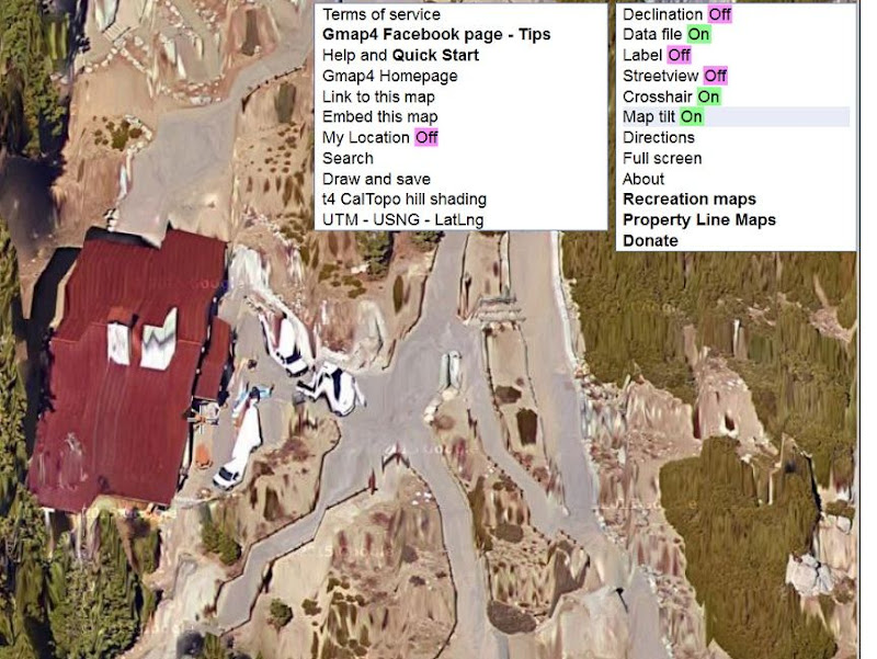
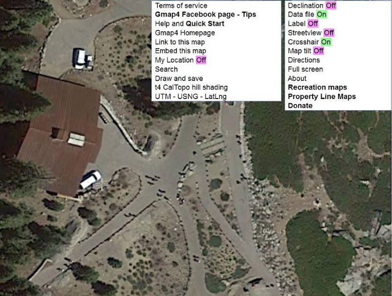
That opens as a topo map but you get to switch among satellite views, street maps, and topo maps and zoom in and out, while staying centered on the same spot. A few months ago I noticed that Google had messed up their closest-zoom satellite views horribly by attempting to model buildings and trees three-dimensionally. At first I was outraged but I discovered that Gmap4 gives you a control for switching between the new scrambled-eggs view and a normal satellite view. It's called "Map tilt" and is found on the Menu pulldown at the top right.


Edited 1 time(s). Last edit at 01/11/2016 04:27PM by gophersnake.
Re: Google satellite views and Street View
January 12, 2016 05:39AM
Thanks for using Gmap4. I am the developer of that browser app.

The way the map looks when it opens on your screen is controlled by parameters that are part of the link. For example, here is a link that opens the map centered near Yosemite Village. The basemap is the Google terrain map and Google's tilt feature is turn off.
http://www.mappingsupport.com/p/gmap4.php?ll=37.744327,-119.589790&z=14&t=t1&tilt=off

To learn more about the link parameters that Gmap4 understands you can visit the Help page and download the pdf file "Link Parameters"
Help page: http://www.mappingsupport.com/p/gmap4_help.html

Anyone can make their own custom Gmap4 links.
1. Make the map look the way you want it to look
2. Click Menu ==> Link to this map.
The link that is displayed will replicate the map on your screen.

Finally, in order to comply with Google's terms of service, the streetview 'pegman' is only displayed when the basemap is one that Google is hosting. There are 4 such basemaps. Those basemap names start m, s, h and t1.
avatar Re: Google satellite views and Street View
January 12, 2016 08:51PM
Quote
Jelf
To learn more about the link parameters that Gmap4 understands you can visit the Help page and download the pdf file "Link Parameters"
Help page: http://www.mappingsupport.com/p/gmap4_help.html

Hey, thanks, Jelf! Bowing to his greatness I've been making lots of use of those maps for my Four Mile Trail project.

Funny that you mention the Gmap4 help page just now. I started checking out those links for the first time last night. I understand quite a bit of what I read there but I'm still pretty lost in the distinction among trackpoints, waypoints, and routepoints. I noticed eventually that "linepoint" was another name for "routepoint" (which helps) but I may still forget that the next time I need to know it. Well, practice may make perfect eventually. tongue sticking out smiley

It's too bad (I think, anyway) that any GPX files I use have to be "http://"; rather than "file://". I can still do lots of practicing and testing using the map-in-a-link method but I'm eventually going to want to store several hundred data points online. Anyone have any pointers on where I could upload .gpx or delimited text files to? I'll bite the bullet and get my own website if I have to...
Re: Google satellite views and Street View
January 13, 2016 04:52AM
Quote
gophersnake
Anyone have any pointers on where I could upload .gpx or delimited text files to? I'll bite the bullet and get my own website if I have to...

You can host files (except html files) on Google Sites and Google Docs. Both are free.
I have some KML/KMZ files on Google Sites and display them with Gmap4.

For step-by-step instructions on using Google Sites with Gmap4, please visit the Help page, download the pdf file "Working with files" and search that pdf on "Google Sites".
Gmap4 Help page: http://www.mappingsupport.com/p/gmap4_help.html
avatar Re: Google satellite views and Street View
January 14, 2016 06:29AM
Gopher guy...
I thought I showed this before... but maybe not.. like this...
It is SUPER EASY to upload GPX to your own sites.google.com...
and then display in gmap4...

Purty sure you will like this one:
http://www.mappingsupport.com/p/gmap4.php?ll=37.732832,-119.587655&z=15&t=t4&q=https://sites.google.com/site/chickontracks/gpx/Old4Mile.gpx

and all kinds of fun here:
http://www.mappingsupport.com/p/gmap4.php?ll=37.730488,-119.587655&z=15&t=t4&q=https://sites.google.com/site/chickontracks/gpx/AllFourMile.gpx

Have fun GS!

Chick-on is looking at you!


Chick-on is looking at you!
avatar Re: Google satellite views and Street View
January 14, 2016 09:04PM
Thanks, C-o! You posted the "Old Four Mile" map here a few years ago: http://yosemitenews.info/forum/read.php?3,66049,66127#msg-66127

I don't think I'd seen the "All Four Mile" one before. By now I know where to look for the location of the GPX file in the Gmap4 link. I downloaded copies of your data points to compare with mine.

Google Sites does sound like a pretty easy and painless way to go, so I'll probably start storing my data there soon.

The map that I'm working on is in the form of a TurboCAD drawing and a list of coordinates for the major data points like switchbacks. I have software for converting back and forth between the coordinates in the drawing and the corresponding latitude, longitude coords. I'm planning to end up with a database of latitude, longitude coords for all my data points (everywhere my version of the trail changes direction), and I don't expect much difficulty turning that info into a GPX file.
avatar Re: Google satellite views and Street View
January 19, 2016 09:58PM
I did set up a Google Site and got some data uploaded that covers the first part of the Four Mile Trail. More here: http://yosemitenews.info/forum/read.php?3,82993
Re: Google satellite views and Street View
January 12, 2016 08:07AM
Nice to hear from the developer! It's a great app....


Check our our website: http://www.backpackthesierra.com/
Or just read a good mystery novel set in the Sierra; https://www.amazon.com/Danger-Falling-Rocks-Paul-Wagner/dp/0984884963
avatar Re: Google satellite views and Street View
January 12, 2016 04:47PM
37.518229° -119.943592°
Find date 7/2006
Sorry, only registered users may post in this forum.

Click here to login