
The Moon is Waxing Gibbous (58% of Full)
Home
>
General Discussion
>
Topic
Re: Where was I?
All posts are those of the individual authors and the owner
of this site does not endorse them. Content should be considered opinion
and not fact until verified independently.
March 31, 2009 06:22PM | Admin Registered: 15 years ago Posts: 17,050 |
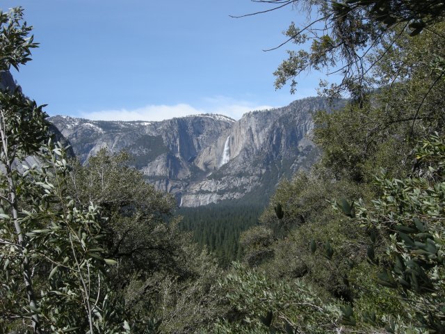
Took this today. Where did I take it from?
|
Re: Where was I? March 31, 2009 06:30PM | Registered: 15 years ago Posts: 70 |
March 31, 2009 06:34PM | Admin Registered: 15 years ago Posts: 17,050 |
March 31, 2009 06:40PM | Registered: 15 years ago Posts: 1,876 |
March 31, 2009 06:54PM | Admin Registered: 15 years ago Posts: 17,050 |
|
Re: Where was I? March 31, 2009 06:43PM | Registered: 15 years ago Posts: 70 |
March 31, 2009 06:55PM | Admin Registered: 15 years ago Posts: 17,050 |
March 31, 2009 07:54PM | Registered: 15 years ago Posts: 1,232 |
|
Re: Where was I? April 01, 2009 08:08PM | Registered: 15 years ago Posts: 0 |
April 01, 2009 08:35PM | Registered: 15 years ago Posts: 1,942 |
Cobalt wrote:
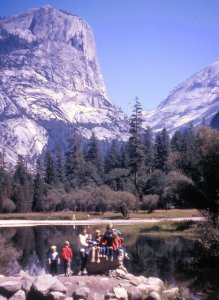
> Here's a photo of me when I was four years old in 1965. Can you
> tell me from where was the photo taken? I'd like to take a
> family photo from that spot when I visit Yosemite next week.
>
>
>
This may be how it looks now at Mirror Lake:
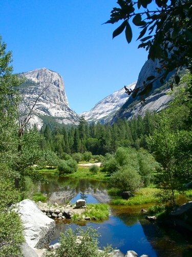
credit: http://www.planetware.com/i/photo/yosemite-national-park-mirror-lake-california-ca316.jpg
The cure for a fallacious argument is a better argument, not the suppression of ideas.
-- Carl Sagan
> Here's a photo of me when I was four years old in 1965. Can you
> tell me from where was the photo taken? I'd like to take a
> family photo from that spot when I visit Yosemite next week.
>
>
>
This may be how it looks now at Mirror Lake:
credit: http://www.planetware.com/i/photo/yosemite-national-park-mirror-lake-california-ca316.jpg
The cure for a fallacious argument is a better argument, not the suppression of ideas.
-- Carl Sagan
|
Re: Where was I? April 01, 2009 09:28PM | Registered: 15 years ago Posts: 0 |
April 01, 2009 09:31PM | Admin Registered: 15 years ago Posts: 17,050 |
|
Re: Where was I? April 01, 2009 09:54PM | Registered: 15 years ago Posts: 0 |
eek:
>From what the shuttle bus driving said it sounded like you can still go to where that picture was taken. It's the full loop that's closed.
That's interesting. Since I have a husband and daughter that will want to know how far they will be waking, can you give me any idea how far from the bus stop to that view?
April 01, 2009 10:14PM | Admin Registered: 15 years ago Posts: 17,050 |
April 01, 2009 10:33PM | Registered: 15 years ago Posts: 1,942 |
eeek wrote:
> Cobalt wrote:
>
> > That's interesting. Since I have a husband and daughter that
> > will want to know how far they will be waking, can you give
> me
> > any idea how far from the bus stop to that view?
>
> I haven't done it in years. But it's pretty much just when you
> get to the lake.
>
As I recall, it is about a mile from the closest shuttle stop. I'm pretty sure you can ride bikes much closer (although not take them on the trail adjacent to the lake) . It used to be possible to drive to a spot close to the lake, so the trail is mostly paved to the Lake. Slight uphill as I recall. Not a difficult hike for someone in average shape. Park maps indicate handicapped access possible by vehicle.
The cure for a fallacious argument is a better argument, not the suppression of ideas.
-- Carl Sagan
April 01, 2009 10:07PM | Registered: 15 years ago Posts: 1,942 |
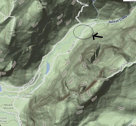
I understood the news reports to suggest that the rockfall fell in this area indicated by the oval. Do not trust this absolutely, but I understood that access to Mirror Lake would still be possible:
The cure for a fallacious argument is a better argument, not the suppression of ideas.
-- Carl Sagan
The cure for a fallacious argument is a better argument, not the suppression of ideas.
-- Carl Sagan
April 01, 2009 10:18PM | Registered: 15 years ago Posts: 1,918 |
|
Re: Where was I? April 01, 2009 10:46PM | Registered: 15 years ago Posts: 0 |
April 02, 2009 05:31AM | Registered: 15 years ago Posts: 1,942 |
Cobalt wrote:
> This is great information...and how did you know we were
> bringing bicycles?
Just trying to be complete. Bikes can be rented at some point of the year at Curry Village and Yosemite Lodge.
http://www.yosemitepark.com/Activities_Biking_BikeRulesandTrailMap.aspx
We seem to like questions and challenges on this list!
Post Edited (04-02-09 05:59)
The cure for a fallacious argument is a better argument, not the suppression of ideas.
-- Carl Sagan
April 02, 2009 07:30AM | Registered: 15 years ago Posts: 1,876 |
|
Re: Where was I? April 02, 2009 09:05AM | Registered: 15 years ago Posts: 141 |
You can ride bikes all the way up to the Mirror Lake view area, but you will see a sign that seems to say you can't. It's for rental bikes, which are supposed to stop at a bike rack about halfway up. Non-rentals don't have to.
Not sure if it's worth taking a bike up to that part though. It's steady uphill and can be "breathtaking", so you end up pushing the bike anyway. Plus, Tenaya Creek will be roaring and scenic, so there are some nice things to see along that walk from the bus stop to the view area.
The water at that spot won't look the same...they quit dredging out the "lake" area many years ago, so it's filled in a lot. But with the spring flow there should be plenty of reflection pools for your photo. And of course Mt. Watkins will still be in the background.
Gary
Yosemite Photo Galleries: http://www.pbase.com/roberthouse/yo
April 03, 2009 06:54AM | Registered: 15 years ago Posts: 1,942 |
Sierrafan wrote:
> The water at that spot won't look the same...they quit dredging
> out the "lake" area many years ago, so it's filled in a lot.
> But with the spring flow there should be plenty of reflection
> pools for your photo. And of course Mt. Watkins will still be
> in the background.
>
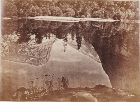
Old photo from about 1868 of Mirror Lake (Sleeping Water) with text that states the lake is 8-20 ft deep. I wonder when the dredging began and ended:
The cure for a fallacious argument is a better argument, not the suppression of ideas.
-- Carl Sagan
> The water at that spot won't look the same...they quit dredging
> out the "lake" area many years ago, so it's filled in a lot.
> But with the spring flow there should be plenty of reflection
> pools for your photo. And of course Mt. Watkins will still be
> in the background.
>
Old photo from about 1868 of Mirror Lake (Sleeping Water) with text that states the lake is 8-20 ft deep. I wonder when the dredging began and ended:
The cure for a fallacious argument is a better argument, not the suppression of ideas.
-- Carl Sagan
April 03, 2009 07:10AM | Registered: 15 years ago Posts: 1,918 |
"Mirror Lake has always been a favorite stopping place for Yosemite tourists, however since 1971 it has been shrinking. The lake was formed on Tenaya Creek by a rockfall dam that was later enlarged by humans, but sediment carried by Tenaya Creek has slowly filled the lake. For several decades (since 1914) the National Park Service (before 1916, the Dept. of Interior) dredged the lake to keep it from filling in and in order to use the sand on roads during the winter. However, in the 1970s, the NPS decided that natural processes should prevail in Yosemite and have since stopped dredging the lake. Eventually, sand and mud will fill in the lake completely... creating a new meadow. A similar process is occurring at Siesta Lake, along the Tioga Road. "
http://www.yosemite.ca.us/faq/4.html
Post Edited (04-03-09 07:13)
Everything I know I learned from
http://www.yosemite.ca.us/faq/4.html
Post Edited (04-03-09 07:13)
Everything I know I learned from
April 03, 2009 08:23AM | Registered: 15 years ago Posts: 1,347 |
April 03, 2009 08:57AM | Admin Registered: 15 years ago Posts: 17,050 |
Sorry, only registered users may post in this forum.

