
The Moon is Waxing Gibbous (61% of Full)
Home
>
General Discussion
>
Topic
Re: Sierra Point
All posts are those of the individual authors and the owner
of this site does not endorse them. Content should be considered opinion
and not fact until verified independently.
April 01, 2009 05:53PM | Admin Registered: 15 years ago Posts: 17,050 |
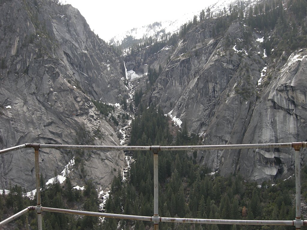
Illilouette Fall:
April 01, 2009 05:57PM | Registered: 15 years ago Posts: 2,321 |
April 01, 2009 06:00PM | Registered: 15 years ago Posts: 1,918 |
April 01, 2009 06:48PM | Admin Registered: 15 years ago Posts: 17,050 |
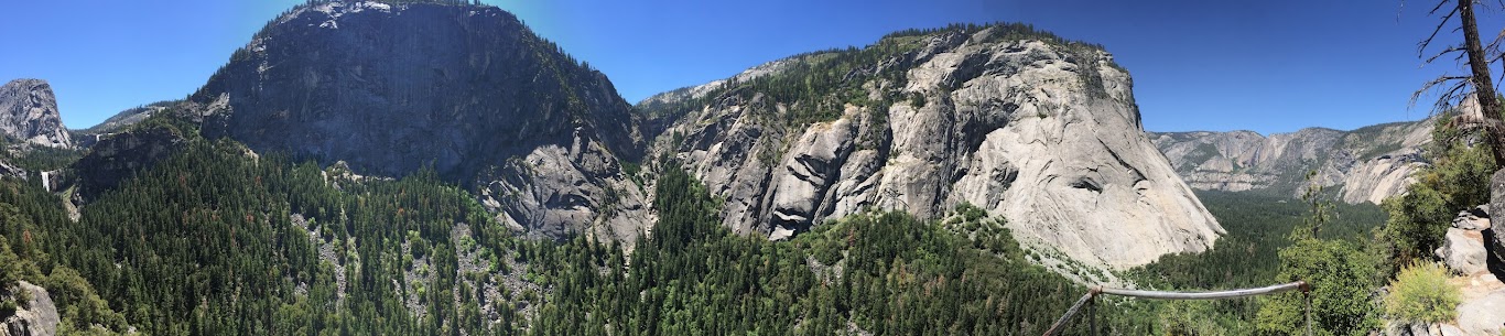
Looking to the right at Sierra Point:
http://yosemitephotos.net/main.php/v/yosemite/sh-dscn2660.jpg.html
http://yosemitephotos.net/main.php/v/yosemite/sh-dscn2660.jpg.html
April 01, 2009 06:54PM | Admin Registered: 15 years ago Posts: 17,050 |
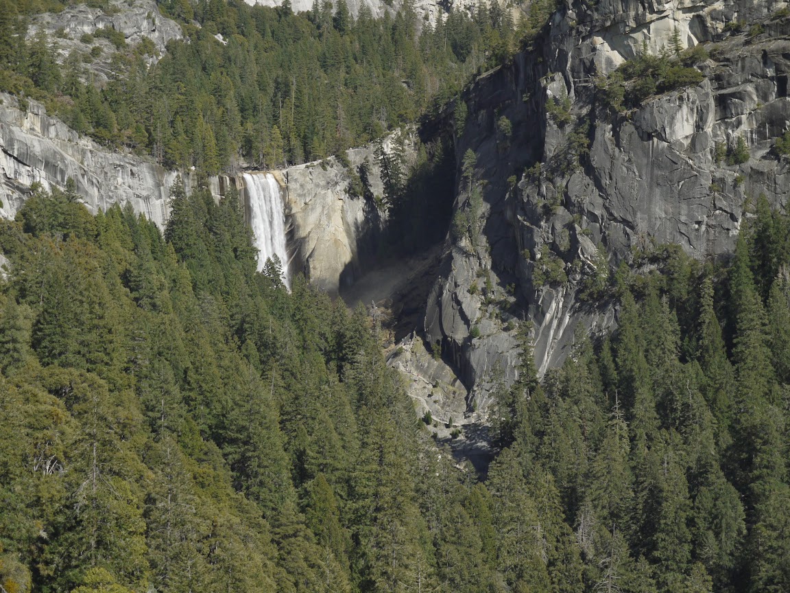
Vernal Fall (avec people at the top) from Sierra Point:
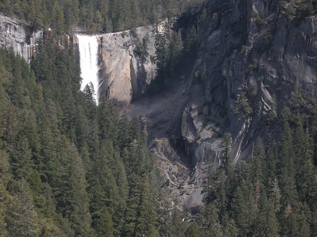
http://yosemitephotos.net/main.php/v/yosemite/sh-dscn2665.jpg.html
http://yosemitephotos.net/main.php/v/yosemite/sh-dscn2665.jpg.html
April 01, 2009 06:59PM | Registered: 15 years ago Posts: 1,942 |
Eeek,
Can you clarify the route you took?
There seem to be two routes: 1. a bushwack from near the start of the trail from Happy Isles to Vernal Falls (near the wooden trail mileage sign) and 2. a route from relatively near the bridge/rest area at base of Vernal Falls, correct?? Which did you use?
It is possible to see the Sierra Point overlook when you are walking back from Vernal Falls to Happy Isles, if you know where to look.
The cure for a fallacious argument is a better argument, not the suppression of ideas.
-- Carl Sagan
April 01, 2009 07:05PM | Admin Registered: 15 years ago Posts: 17,050 |
Frank Furter wrote:
> Can you clarify the route you took?
> There seem to be two routes: 1. a bushwack from near the start
> of the trail from Happy Isles to Vernal Falls (near the wooden
> trail mileage sign)
It's a bit up the trail from the sign. Look for the rock piles sign on the left:
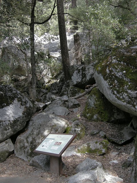
http://yosemitephotos.net/main.php/v/yosemite/sh-dscn2672.jpg.html
> 2. a route from relatively near the
> bridge/rest area at base of Vernal Falls, correct??
No, that probably doesn't exist.
> It is possible to see the Sierra Point overlook when you are
> walking back from Vernal Falls to Happy Isles, if you know
> where to look.
Yes, I could see a section of the trail from Sierra Point.
> Can you clarify the route you took?
> There seem to be two routes: 1. a bushwack from near the start
> of the trail from Happy Isles to Vernal Falls (near the wooden
> trail mileage sign)
It's a bit up the trail from the sign. Look for the rock piles sign on the left:
http://yosemitephotos.net/main.php/v/yosemite/sh-dscn2672.jpg.html
> 2. a route from relatively near the
> bridge/rest area at base of Vernal Falls, correct??
No, that probably doesn't exist.
> It is possible to see the Sierra Point overlook when you are
> walking back from Vernal Falls to Happy Isles, if you know
> where to look.
Yes, I could see a section of the trail from Sierra Point.
|
Re: Sierra Point August 12, 2015 10:15AM | Registered: 8 years ago Posts: 21 |
April 01, 2009 07:00PM | Admin Registered: 15 years ago Posts: 17,050 |
April 01, 2009 07:15PM | Admin Registered: 15 years ago Posts: 17,050 |
April 01, 2009 07:44PM | Registered: 15 years ago Posts: 1,942 |
The last time I walked from the Vernal Falls rest area toward Happy Isles, within the first 100 yds or so I could see the Sierra Point pipe/safety rail.
At about that point, I noticed a rock fall to the right (north) and the remains of an old trail which grossly appeared to go up hill. It is above "eye level" and not in the direction most people are looking. I wonder what that "trail" was all about. It is hard to determine on the old maps just where the Sierra Point trail used to go.
The cure for a fallacious argument is a better argument, not the suppression of ideas.
-- Carl Sagan
|
Re: Sierra Point April 01, 2009 08:30PM | Registered: 15 years ago Posts: 141 |
Frank Furter wrote:
> The last time I walked from the Vernal Falls rest area toward
> Happy Isles, within the first 100 yds or so I could see the
> Sierra Point pipe/safety rail.
> At about that point, I noticed a rock fall to the right (north)
> and the remains of an old trail which grossly appeared to go up
> hill. It is above "eye level" and not in the direction most
> people are looking. I wonder what that "trail" was all about.
> It is hard to determine on the old maps just where the Sierra
> Point trail used to go.
>
It's not hard to find once you've found it a time or two. Doesn't sound like anything in the vicinity you describe though.
I've had pretty positive reports of finding it using this
http://www.pbase.com/roberthouse/sierratrail
and if you can't find it, you have the option of going fairly straight up the loose dirt and rock next to the granite slab and first rockfall.
There's a lot of the old trail left, you just have to know what to do when it stops and disappears, mostly in one bad spot at the rockslide.
Post Edited (04-01-09 20:30)
Gary
Yosemite Photo Galleries: http://www.pbase.com/roberthouse/yo
April 01, 2009 07:56PM | Admin Registered: 15 years ago Posts: 17,050 |
April 01, 2009 08:04PM | Registered: 15 years ago Posts: 1,942 |
eeek wrote:
> Sierra Point on Wikipedia:
>
> http://en.wikipedia.org/wiki/Sierra_Point,_Yosemite,_California
>
Roger that.
Additional old links that show some of the Sierra Point trail:
http://www.yosemite.ca.us/library/maps/yosemite_valley_map_1941.png
http://www.yosemite.ca.us/library/yosemite_resources/images/illustration_226.jpg
http://www.yosemite.ca.us/library/maps/yosemite_valley_map_1964.jpg
Maybe I was seeing an old route of the Happy Isles to Vernal Falls trail.
The cure for a fallacious argument is a better argument, not the suppression of ideas.
-- Carl Sagan
April 04, 2009 09:14AM | Registered: 15 years ago Posts: 1,942 |
Sierrafan wrote:
> Frank Furter wrote:
> > The last time I walked from the Vernal Falls rest area
> toward
> > Happy Isles, within the first 100 yds or so I could see the
> > Sierra Point pipe/safety rail.
> > At about that point, I noticed a rock fall to the right
> (north)
> > and the remains of an old trail which grossly appeared to go
> up
> > hill. It is above "eye level" and not in the direction most
> > people are looking. I wonder what that "trail" was all
> about.
Slowly all the dots are beginning to connect. It is a mobius strip-- we come back to the earlier posts. Finally able to understand exactly what was described in earlier posts (2008) on the Anderson Trail, Snow Hotel, La Casa Nevada. I didn't understand that earlier post until now. Everyone should look for this old track the next time they go to Vernal Falls! Worth reviewing the old thread:
http://yosemitenews.info/forum/read.php?f=1&i=5049&t=4782
The cure for a fallacious argument is a better argument, not the suppression of ideas.
-- Carl Sagan
April 04, 2009 11:47AM | Registered: 15 years ago Posts: 423 |
April 04, 2009 12:40PM | Admin Registered: 15 years ago Posts: 17,050 |

April 04, 2009 12:45PM | Admin Registered: 15 years ago Posts: 17,050 |
|
Re: Sierra Point August 07, 2011 09:46AM | Registered: 13 years ago Posts: 931 |
How tough is that "root route" section? Trekking poles recommended for balance?
August 07, 2011 01:02PM | Admin Registered: 15 years ago Posts: 17,050 |
Quote
Ohnivy-Drak
How tough is that "root route" section? Trekking poles recommended for balance?
I didn't have any need for poles. YMMV.
August 07, 2011 10:20PM | Registered: 15 years ago Posts: 4,173 |
Quote
eeek
Quote
Ohnivy-Drak
How tough is that "root route" section? Trekking poles recommended for balance?
I didn't have any need for poles. YMMV.
Not sure if it specifically applies to the "root route", but bill-e-g did recommend to bring along hiking sticks (see his last message on this thread, dated April 05, 2009).
Edited 1 time(s). Last edit at 08/07/2011 10:22PM by plawrence.
August 08, 2011 08:55PM | Registered: 14 years ago Posts: 675 |
Absolutely...the viewpoint is at something like 5200 ft elevation, so as long as the snow level is not way down, and so long as it has been somewhat dry and not too, too cold (i.e. no lingering ice) it should be fine. I was up there in both April and May of this year (big snow year..remember?) and had no snow or ice related issues.Quote
hotrod4x5
Do-able in winter?
August 08, 2011 11:25PM | Registered: 15 years ago Posts: 4,173 |
Quote
Bearproof
Absolutely...the viewpoint is at something like 5200 ft elevation, so as long as the snow level is not way down, and so long as it has been somewhat dry and not too, too cold (i.e. no lingering ice) it should be fine. I was up there in both April and May of this year (big snow year..remember?) and had no snow or ice related issues.
So in your opinion, what's the hardest portion of the old Sierra Point Trail to traverse?
August 09, 2011 12:08PM | Registered: 15 years ago Posts: 1,876 |
Quote
plawrence
Quote
Bearproof
Absolutely...the viewpoint is at something like 5200 ft elevation, so as long as the snow level is not way down, and so long as it has been somewhat dry and not too, too cold (i.e. no lingering ice) it should be fine. I was up there in both April and May of this year (big snow year..remember?) and had no snow or ice related issues.
So in your opinion, what's the hardest portion of the old Sierra Point Trail to traverse?
Stepping around the rattlesnakes in the rocks near the bottom?
August 10, 2011 08:12AM | Registered: 14 years ago Posts: 7,421 |
Quote
plawrence
Quote
eeek
Quote
Ohnivy-Drak
How tough is that "root route" section? Trekking poles recommended for balance?
I didn't have any need for poles. YMMV.
Not sure if it specifically applies to the "root route", but bill-e-g did recommend to bring along hiking sticks (see his last message on this thread, dated April 05, 2009).
Perhaps eeeeeeek forgot this comment:
http://yosemitenews.info/forum/read.php?3,19936,20045#msg-20045
w/r to Hiking Poles... Unless I'm staying on a maintained trail that is snow free the entire trip and doesn't
have steep downhill portions I take hiking poles. (so I pretty much take poles all the time)
Sierra Pt. trail is not maintained and will have loose sand/gravel and leaves on it.
I've mentioned that the trail is easy and super fun in the past... then took OD on it... and changed my mind to YMMV.
He did great... but it's not trivial like a maintained trail (YMMV!)
http://yosemitenews.info/forum/read.php?3,28503,28569#msg-28569

August 10, 2011 01:25PM | Admin Registered: 15 years ago Posts: 17,050 |
Quote
chick-on
Perhaps eeeeeeek forgot this comment:
http://yosemitenews.info/forum/read.php?3,19936,20045#msg-20045
I wasn't on the trail at that point.
August 10, 2011 01:43PM | Registered: 14 years ago Posts: 675 |
Quote
plawrence
So in your opinion, what's the hardest portion of the old Sierra Point Trail to traverse?
From a technical perspective or a routefinding perspective? Actually niether are very tough
1. Routefinding: at the starting point on the mist trail (the rockpiles? sign) I tend to want to keep going up and to the right, onto a steep sand slope that obviously a lot of people use to go both up and down. Its certainly doable, but the old trail zigzags back and forth further north (or left going uphill)
2. Technically the toughest part is a short hand and foot climb that goes up and left, I would call it class two and a half or so. Take a look:
Once over that its a matter of following the old steps...and they don't make 'em like that any more...pretty steep and in a few places they have fallen away, but nothing "hard", just steep. And the only "traverse" that I recall is quite near the top and is a narrow trail with no real issues.
August 10, 2011 03:25PM | Registered: 15 years ago Posts: 4,173 |
April 05, 2009 08:58PM | Registered: 15 years ago Posts: 1,918 |
Here are my photos from April 5, 2009.

https://picasaweb.google.com/yosemite.chick.on/SierraPoint?authkey=Gv1sRgCPWXoe7W9JXNCA#
THANKS EEEK! Awesome place.
The trail is very very easy to find. Just before "rock falls" sign.
Recommend you bring hiking sticks.
Post Edited (04-05-09 20:59)
Everything I know I learned from
Edited 2 time(s). Last edit at 09/14/2011 05:56PM by bill-e-g.
|
Re: Sierra Point August 07, 2011 09:57PM | Registered: 13 years ago Posts: 1,697 |
|
Re: Sierra Point August 16, 2011 07:04PM | Registered: 13 years ago Posts: 49 |
|
Re: Sierra Point August 16, 2011 10:25PM | Registered: 13 years ago Posts: 931 |
Quote
Sandpiper11
I wouldn't do it if there is any chance of ice. It was slippery without any added issues. I did it without hiking poles in June, mainly because there was a lot of scrambling with hands. Definitely worth the hike though.
Nothing wrong with the use of hands, crawling/sitting on your butt, etc. Not a place to be worried about appearance, or lack thereof.
|
Re: Sierra Point August 17, 2011 08:38AM | Registered: 13 years ago Posts: 49 |
|
Re: Sierra Point August 17, 2011 10:08AM | Registered: 13 years ago Posts: 617 |
Our (sadly still only) annual trek to Yosemite is coming up in a couple more weeks (we scheduled it later in the season this year so we'd be sure of getting in some time on the "off-the-Tioga-Road" trails). We'll be splitting our stay between Yosemite West and White Wolf. One of the things I think I'd like to try during our "near-the-Valley" leg is Sierra Point (and possibly the Anderson Trail). Between this thread and the wonderfully step-by-step description here, I'm pretty set on finding it but can someone tell me about how far it is from the Mist turnoff to SP? It looks like it's not much more than a mile or two but, unless I'm missing it, I can't find any mention of the actual distance. Anybody got a ballpark figure for me?
--David K
--David K
August 17, 2011 12:23PM | Admin Registered: 15 years ago Posts: 17,050 |
Quote
DavidK42
Our (sadly still only) annual trek to Yosemite is coming up in a couple more weeks (we scheduled it later in the season this year so we'd be sure of getting in some time on the "off-the-Tioga-Road" trails). We'll be splitting our stay between Yosemite West and White Wolf. One of the things I think I'd like to try during our "near-the-Valley" leg is Sierra Point (and possibly the Anderson Trail). Between this thread and the wonderfully step-by-step description here, I'm pretty set on finding it but can someone tell me about how far it is from the Mist turnoff to SP? It looks like it's not much more than a mile or two but, unless I'm missing it, I can't find any mention of the actual distance. Anybody got a ballpark figure for me?
--David K
Not sure what you mean by the Mist turnoff. The Sierra Point "trail" very close to Happy Isles.
August 17, 2011 12:35PM | Registered: 15 years ago Posts: 4,173 |
Quote
eeek
Quote
DavidK42
Our (sadly still only) annual trek to Yosemite is coming up in a couple more weeks (we scheduled it later in the season this year so we'd be sure of getting in some time on the "off-the-Tioga-Road" trails). We'll be splitting our stay between Yosemite West and White Wolf. One of the things I think I'd like to try during our "near-the-Valley" leg is Sierra Point (and possibly the Anderson Trail). Between this thread and the wonderfully step-by-step description here, I'm pretty set on finding it but can someone tell me about how far it is from the Mist turnoff to SP? It looks like it's not much more than a mile or two but, unless I'm missing it, I can't find any mention of the actual distance. Anybody got a ballpark figure for me?
--David K
Not sure what you mean by the Mist turnoff. The Sierra Point "trail" very close to Happy Isles.
The original start of the Sierra Point trail was where the JMT/Mist Trail crossed over Merced at the bridge (that's was damaged, then removed, after the 1997 flood) near the Happy Isle Nature Center. There's a small debate about what is the best route to scramble up that rockfall near the start of the original trail. But where that bridge was located was the original start of the old Sierra Point Trail.
Edited 1 time(s). Last edit at 08/17/2011 10:06PM by plawrence.
August 17, 2011 04:50PM | Registered: 14 years ago Posts: 675 |
|
Re: Sierra Point August 17, 2011 07:47PM | Registered: 13 years ago Posts: 49 |
|
Re: Sierra Point August 18, 2011 04:23AM | Registered: 13 years ago Posts: 617 |
|
Re: Sierra Point August 18, 2011 04:22AM | Registered: 13 years ago Posts: 617 |
August 18, 2011 08:45AM | Registered: 12 years ago Posts: 159 |
It's easy to find. The unofficial trail is only a couple hundred yards from the official mileage sign at the beginning of the trail at Happy Isles and just past the rockfall sign. You shared the link to the same website I used to find the trail. You will have no problem finding it...unlike everyone else who walks by, you just have to be looking for it! Once off the trail, watch for the cairns to guide you. Have fun!
"It is all very beautiful and magical here - a quality which cannot be described. You have to live it and breath it., let the sun bake it into you" - Ansel Adams
"It is all very beautiful and magical here - a quality which cannot be described. You have to live it and breath it., let the sun bake it into you" - Ansel Adams
August 18, 2011 12:20PM | Admin Registered: 15 years ago Posts: 17,050 |
Quote
DavidK42
Quote
eeek
Not sure what you mean by the Mist turnoff. The Sierra Point "trail" very close to Happy Isles.
I just meant where you turn off the Mist Trail by the rock slides sign (as described earlier in this thread).
You don't turn off the Mist Trail; you turn off the John Muir Trail.
http://yosemitephotos.net/main.php/v/yosemite/sh-dscn2672.jpg.html
Edited 1 time(s). Last edit at 08/18/2011 12:20PM by eeek.
August 18, 2011 01:56PM | Registered: 15 years ago Posts: 4,173 |

August 18, 2011 01:58PM | Admin Registered: 15 years ago Posts: 17,050 |
August 18, 2011 02:27PM | Registered: 15 years ago Posts: 4,173 |
Quote
eeek
Quote
plawrence
Quote
eeek
You don't turn off the Mist Trail; you turn off the John Muir Trail.
I think the John Muir Trail and the Mist Trail are multiplexed at that point.
No, they aren't.
Technically, your correct. I'm not disputing that.
But in real life, most people consider that part of the JMT as part of the Mist Trail too. Most people think that the Mist Trail starts at Happy Isle. If you ask most rangers in Yosemite how to get to the Mist Trail (I've heard this countless of times while waiting to speak to a ranger at the Yosemite Valleys Visitor Center), the ranger will tell the person to take the Shuttle Bus to the Happy Isle bus stop and cross the bridge to the start of the Mist Trail.
They DON'T state words to this effect "get off the bus, cross the bridge and then take the John Muir Trail to its junction with the Mist Trail which is located across the bridge below Vernal Falls". They just state to get off the bus, cross the bridge, and start on the trail.
|
Re: Sierra Point August 18, 2011 02:57PM | Registered: 15 years ago Posts: 72 |
|
Re: Sierra Point August 21, 2011 09:07AM | Registered: 13 years ago Posts: 693 |
My experience was much like Bearproof described. Went up in June and I couldn't control my urge to go to the right and ended up on the sandy slope. There was metal poles and cable in the slide debris, so I thought I must be heading in the right direction. I eventually found a real trail. The route was clearer and easier on the way down. (Except that steep slippery section was much harder to descend.)
Love those little rock steps...some places were so narrow, I had to squeeze through with all of my gear.
June was buggy, hot, and I didn't expect to see any one, but saw a family with small children on their way down and a couple at the point(...a guy talking was on his phone.)
My first time up to the point was in 1978 and I returned a few years after that. The trail was in better condition then, but it was officially closed in 1977, along with the Tenaya Canyon trail.
August 21, 2011 03:11PM | Registered: 15 years ago Posts: 670 |
August 21, 2011 03:43PM | Registered: 15 years ago Posts: 4,173 |
Quote
qumqats
Quote
hikerchick395
. . . snip . . .
, but it was officially closed in 1977, along with the Tenaya Canyon trail.
?
Tenaya Canyon Canyon Trail?
?
where did it start/end?
why was it closed?
Here's a link to a relatively recent (2010) trail report on the Tenaya Canyon Trail submitted by a member of the Sierra Club:
SierraClub.org: Tenaya Canyon Trail
Edited 1 time(s). Last edit at 08/21/2011 03:44PM by plawrence.
August 21, 2011 05:48PM | Registered: 15 years ago Posts: 670 |
He's describing the hike to Hidden Falls, although he doesn't seem to know that.
This is on the south side of the canyon. There's also a climbers trail ( watch out for the poison oak! ) up to the routes on Mt Watkins on the north side of the canyon.
However neither of these are or have ever been ( as far as I know ) official and are off trail usage trails.
This is on the south side of the canyon. There's also a climbers trail ( watch out for the poison oak! ) up to the routes on Mt Watkins on the north side of the canyon.
However neither of these are or have ever been ( as far as I know ) official and are off trail usage trails.
|
Re: Sierra Point September 11, 2011 10:09PM | Registered: 13 years ago Posts: 931 |
As previously mentioned in the other forum, I abandoned my journey to Sierra Point about 2/3 way up. The weather was not too my liking, and I tend to be more on the cowardly/safer side of things. From email exchanges with someone who has been up there a few times, I took his advice and started from the High Sierra Loop Trail sign instead of the Rock Piles. I must say it was rather simple to find and follow the ducks from that starting point. There were at least 7 of them before I turned around. The insects were more of a challenge than the steepness, I must say. Those things are just brutal and relentless.
I hope to finish next time.
I hope to finish next time.
September 14, 2011 05:53PM | Registered: 14 years ago Posts: 7,421 |
|
Re: Sierra Point September 18, 2011 08:05PM | Registered: 12 years ago Posts: 30 |
September 18, 2011 08:54PM | Registered: 15 years ago Posts: 2,321 |
September 18, 2011 09:51PM | Registered: 15 years ago Posts: 670 |
I'm not sure I'd want my first trip up there to be in winter where you might have trouble finding the trail.
If you've been up there before and know where to go, winter won't be a problem except maybe when the snow is at it's deepest.
YMMV, use caution, know your limit, don't hesitate to turn back.
If you've been up there before and know where to go, winter won't be a problem except maybe when the snow is at it's deepest.
YMMV, use caution, know your limit, don't hesitate to turn back.
|
Re: Sierra Point October 09, 2011 07:49PM | Registered: 13 years ago Posts: 931 |
Found a book first published in 1979, "Yosemite Trails" by Lewis Clark. It has a picture of an older High Sierra Loop Trail sign, which I captured with my crappy cell phone cam feature. In the book, there's a short paragraph about how this trail isn't recommended because it's steep and unmaintained.
Sierra Point 0.7 listed at the top. No mention of LYV or the Emerald Pool.
Sierra Point 0.7 listed at the top. No mention of LYV or the Emerald Pool.
|
Re: Sierra Point March 29, 2014 12:30PM | Registered: 11 years ago Posts: 194 |

|
Re: Sierra Point March 29, 2014 03:19PM | Registered: 11 years ago Posts: 324 |
|
Re: Sierra Point March 29, 2014 03:36PM | Registered: 11 years ago Posts: 194 |
March 30, 2014 12:04PM | Admin Registered: 15 years ago Posts: 17,050 |
|
Re: Sierra Point April 06, 2014 04:09PM | Registered: 11 years ago Posts: 194 |
Quote
eeek
Quote
Royalist
(To Eeek): Shouldn't this thread be under the Yosemite, Sierra, etc., forum?
Look at its start date.
I know; I meant that you might want to consider moving this thread to that forum because that is the logical home for it and new postings to it are of interest to the audience for that forum. I suspect that I am not the only person who does not always keep up with new postings to the other forums (admonishments from Chick-On notwithstanding).
April 06, 2014 05:07PM | Admin Registered: 15 years ago Posts: 17,050 |
Quote
Royalist
I meant that you might want to consider moving this thread to that forum because that is the logical home for it and new postings to it are of interest to the audience for that forum.
Moving would obsolete the search engine listings. So I'm reluctant to move old threads.
[/quote]I suspect that I am not the only person who does not always keep up with new postings to the other forums (admonishments from Chick-On notwithstanding).[/quote]
Look at the upper right corner of the page. The "Recent Posts" link solves that problem.
|
Re: Sierra Point June 22, 2015 04:39PM | Registered: 8 years ago Posts: 84 |
I just did this hike with my wife and a friend using these photos to get us there. They worked like a charm! We only saw 5 people on their way back, otherwise, we had the place to ourselves. It was really cool seeing people on the JMT below us not knowing we were a few hundred feet above them and all alone.
Illilouette Falls was more of a trickle, but we were able to see all 4 falls. Will definitely go back again. Thanks for all the good info.
Illilouette Falls was more of a trickle, but we were able to see all 4 falls. Will definitely go back again. Thanks for all the good info.
|
Re: Sierra Point September 21, 2015 10:24AM | Registered: 8 years ago Posts: 4 |
Hi All! Just completed this gem of a hike this past weekend. Middle of the day and had the ENTIRE hike all to ourselves. It was such a wonderful feeling having this level of solitude right in the middle of all the action taking place on the trails further below.
Quick question -- anyone happen to know the stats of this hike? As in, what's the mileage and elevation gain?
Thanks!
Quick question -- anyone happen to know the stats of this hike? As in, what's the mileage and elevation gain?
Thanks!
Sorry, only registered users may post in this forum.

