Welcome! Log In Create A New Profile Recent Posts
Deer in Yosemite

The Moon is Waxing Gibbous (83% of Full)


Advanced

Public Input Sought on Rogers Peak Environmental Assessment

All posts are those of the individual authors and the owner of this site does not endorse them. Content should be considered opinion and not fact until verified independently.

avatar Public Input Sought on Rogers Peak Environmental Assessment
December 15, 2018 12:33PM


DEATH VALLEY, CA – The National Park Service (NPS) seeks public input on proposals to construct and operate telecommunications infrastructure on Rogers Peak, located in Death Valley National Park’s Panamint Mountains.

If the NPS approves the right-of-way permits, the following infrastructure would be added or changed:
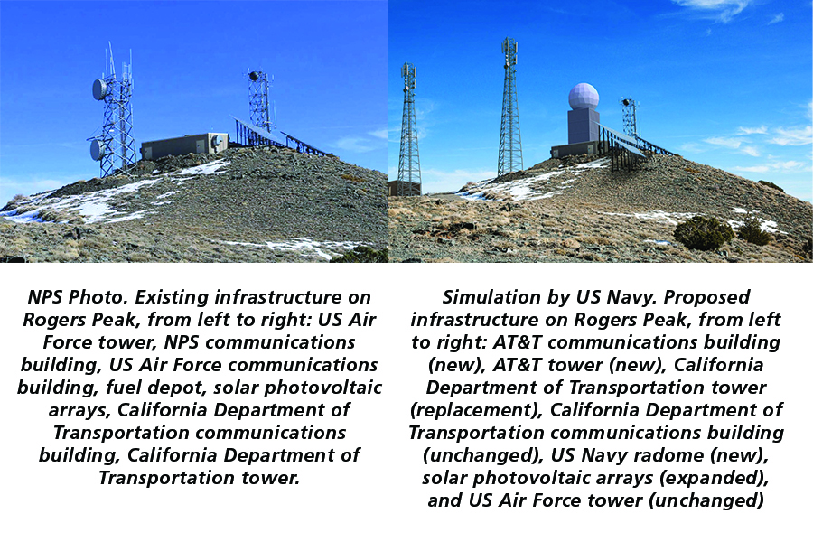
  • Navy Radome: China Lake Naval Air Weapons Station would build a 28-foot-diameter dome containing a telemetry antenna. This would be located on top of a support building, with a combined height of up to 60 feet. The telemetry antenna would provide enhanced monitoring of all military branches’ use of the R-2508 airspace.
  • AT&T tower – AT&T Wireless would transmit cellular service from a tower up to 99 feet tall. This would provide cellular service in parts of Panamint Valley and Death Valley that currently have no signal. There would likely be capacity on this tower for other agencies or companies to co-locate in the future.
  • Caltrans tower – The California Department of Transportation (Caltrans) owns a 50-foot-tall tower that is over-allocated and structurally unsound. Caltrans would remove this tower and construct a replacement tower up to 99 feet tall. The Caltrans tower also hosts communications equipment for Southern California Edison and multiple federal, state, and local agencies.
  • Support infrastructure – Two small support buildings would be removed; their equipment would be moved to the base of the radome. AT&T would require a support building. Existing propane tanks would be increased in capacity and relocated. Solar panels arrays would be increased in size, and potentially installed in a new location.
Death Valley National Park is part of the Basin and Range Province, which consists of mostly north-south trending mountain ranges alternating with valleys. These geography makes mountain summits ideal locations for wireless communications. Most of Death Valley National Park’s 5,300 square miles are off-limits for this type of development due to wilderness designation. The 9,990-foot summit of Rogers Peak has a 2 ½-acre area of non-wilderness where construction of permanent structures can be considered.

Rogers Peak has housed telecommunications infrastructure since 1959. Currently, the National Park Service, the US Air Force, the Bureau of Land Management, the Federal Bureau of Investigation, the National Oceanic and Atmospheric Administration, Caltrans, the California Office of Emergency Services, the California Highway Patrol, Inyo County, and Southern California Edison have infrastructure on Rogers Peak. This existing infrastructure consists of a 50-foot Caltrans tower, 62-foot Air Force tower, three support buildings, propane tanks, and solar panels.

Initial public opinions of this proposal were divided, especially regarding the proposed cellular site. Some people expressed support, stating that increased cell coverage area would increase safety. Others opposed the proposed cellular tower, stating that one of the things they value about wilderness is an escape from technology.

Death Valley National Park encourages public participation throughout the planning process. The Rogers Peak Multi-Use Instrumentation and Communications Facility Environmental Assessment can be viewed online at http://parkplanning.nps.gov/deva. Comments can be submitted at the same website or mailed to Death Valley National Park, ATTN: Rogers Peak Environmental Assessment, P.O. Box 579, Death Valley, CA 92328 by January 13, 2019.

Before including your address, phone number, email address, or other personal identifying information in your comment, you should be aware that your entire comment, including your personal identifying information, might be made publicly available at any time. While you can ask in your comment to withhold your personal identifying information from public review, the National Park Service cannot guarantee that it will be able to do so.


Edited 1 time(s). Last edit at 12/15/2018 12:37PM by eeek.
avatar Re: Public Input Sought on Rogers Peak Environmental Assessment
December 15, 2018 12:44PM
avatar Rogers Peak Public Comment Period Extended
February 05, 2019 12:13PM
DEATH VALLEY, CA – The public has extra time to comment about proposed telecommunications infrastructure on Death Valley’s Rogers Peak. Due to disruptions from the 5-week government shutdown, the National Park Service has extended the public comment opportunity through February 25. The proposed changes would increase the area’s cellular service and affect some views.

If the NPS approves the right-of-way permits, the following infrastructure could be added or changed:
  • Navy radome: China Lake Naval Air Weapons Station would build a 28-foot-diameter dome containing a telemetry antenna. This would be located on top of a support building, with a combined height of up to 60 feet. The telemetry antenna would provide enhanced monitoring of all military branches’ use of the R-2508 airspace.
  • AT&T cell tower – AT&T Wireless would transmit cellular service from a tower up to 99 feet tall. This would provide cellular service in parts of Panamint Valley and Death Valley that currently have no signal. There would likely be capacity on this tower for other agencies or companies to co-locate in the future.
  • Caltrans communications tower – The California Department of Transportation (Caltrans) owns a 50-foot-tall tower that is over-allocated and structurally unsound. Caltrans would remove this tower and construct a replacement tower up to 99 feet tall. The Caltrans tower also hosts communications equipment for Southern California Edison and multiple federal, state, and local agencies.
  • Support infrastructure – Two small support buildings would be removed; their equipment would be moved to the base of the radome. AT&T could add a support building. Existing propane tanks would be increased in capacity and relocated. Solar panel arrays would be increased in size, and potentially installed in a new location.
Death Valley National Park is part of the Basin and Range Province, which consists of mostly north-south trending mountain ranges alternating with valleys. This geography makes mountain summits ideal locations for wireless communications. Most of the park’s 5,300 square miles are off-limits for this type of development due to wilderness designation. The 9,990-foot summit of Rogers Peak has a 2 ½-acre area of non-wilderness where construction of permanent structures can be considered.

Rogers Peak has housed telecommunications infrastructure since 1959. Currently, the National Park Service, the US Air Force, the Bureau of Land Management, the Federal Bureau of Investigation, the National Oceanic and Atmospheric Administration, Caltrans, the California Office of Emergency Services, the California Highway Patrol, Inyo County, and Southern California Edison have infrastructure on Rogers Peak. This existing infrastructure consists of a 50-foot Caltrans tower, 62-foot Air Force tower, three support buildings, propane tanks, and solar panels.

Initial public opinions of this proposal were divided, especially regarding the proposed cellular site. Some people expressed support, stating that increased cell coverage area would increase safety. Others opposed the proposed cellular tower, stating that one of the things they value about wilderness is an escape from technology.

Death Valley National Park encourages public participation. The Rogers Peak Multi-Use Instrumentation and Communications Facility Environmental Assessment can be viewed online at http://parkplanning.nps.gov/deva.

Comments can be submitted at the same website or mailed to Death Valley National Park, ATTN: Rogers Peak Environmental Assessment, P.O. Box 579, Death Valley, CA 92328 by February 25, 2019. Responders should be aware that responses are not confidential.
avatar Rogers Peak Telecommunications Site Assessment Completed
May 19, 2019 03:49PM
DEATH VALLEY, CA – The National Park Service (NPS) has completed an Environmental Assessment (EA) of proposed additions and modifications to telecommunications infrastructure on Rogers Peak in Death Valley National Park. Major requested additions are a cell tower and a military radome.

Rogers Peak, elevation 9,990 feet, has been used for relaying wireless communications since 1959. Today it is the only non-wilderness high point in the park. It has two towers, three support buildings, solar panels, propane tanks, and an administrative-use-only road to the site. Southern California Edison, Caltrans and other state agencies, Inyo County agencies, Federal Bureau of Investigation, Bureau of Land Management, and NPS use the mountain for communications.

The U.S. Navy proposes to build a 28-foot diameter radome with a total height of not more than 60 feet. The equipment inside will support safety, communications, and tracking in the R-2508 military airspace, which includes the park.

AT&T Wireless proposes to build a cellular tower on Rogers Peak, which would likely add areas of cellular service. This part of the EA drew the most emotional public comments. Some people objected to any increase in cellular coverage, expressing a desire to keep the wilderness free of cellular service or to have the park be a place to “get off the grid.” Other people strongly supported the potential increase in coverage area, citing shorter response times in case of emergencies.

The Finding of No Significant Impact, signed on April 1, is the first step in approving modifications and new construction on the site. The NPS outlined specific stipulations which will be carried forward into construction and right-of-way permits, which have not yet been issued. Construction is not expected to start before the summer of 2020.

The EA can be viewed at: https://parkplanning.nps.gov/RogersPeak.
Sorry, only registered users may post in this forum.

Click here to login