Welcome! Log In Create A New Profile Recent Posts
A Yosemite bear

The Moon is Waxing Gibbous (57% of Full)


Advanced

Easiest route to the Diving Board

All posts are those of the individual authors and the owner of this site does not endorse them. Content should be considered opinion and not fact until verified independently.

Easiest route to the Diving Board
March 01, 2014 12:58AM
OK. Chick-on and others have goaded me into saying more about the easiest route to the Diving Board. There has been a lot of talk about this, scattered over a bunch of threads. It's a wonderful place.
http://yosemitenews.info/forum/read.php?3,44814,44951#msg-44951

First, this not about the fastest route. From either Happy Isles or Little Yosemite Valley, that would be the climbers trail:
http://yosemitenews.info/forum/read.php?17,72545,72558#msg-72558
http://yosemitenews.info/forum/read.php?17,72545,72643#msg-72643

It's also not about the slowest route. That would be to take the Half Dome Trail to the sub-dome, then down the climbers trail to the base of the face, then across that and up to the Diving Board. Steve Roper's book says it's a walk. He's crazy.
http://yosemitenews.info/forum/read.php?3,44869,44955#msg-44955

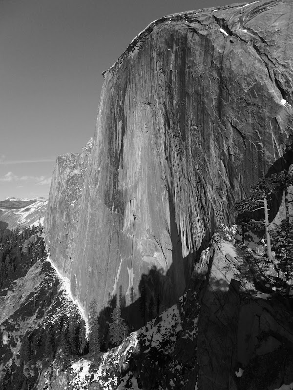
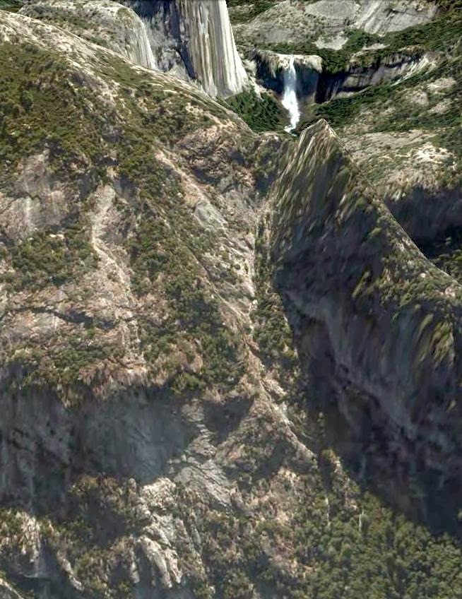
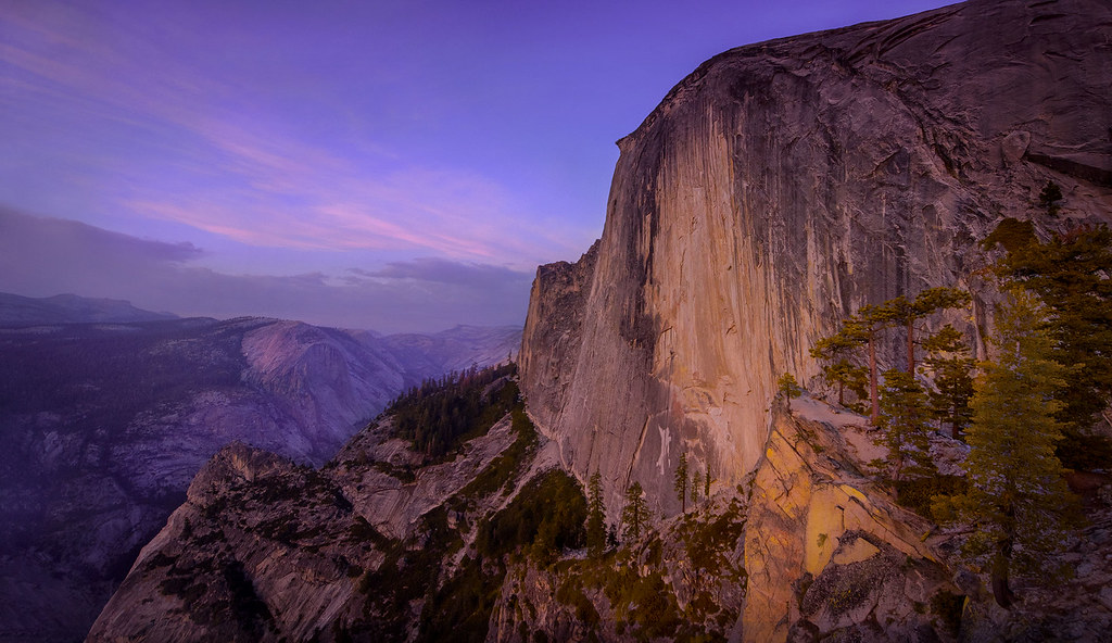
I've done both of those. This thread is about what to do when your fit grandchildren and photographer friends want to go up to the Diving Board and retake Ansel Adams' famous photo of April 17, 1927:


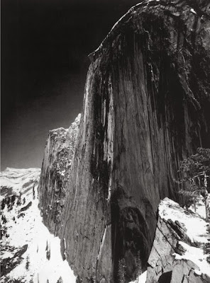
This thumbnail is off the web, and the photo is copyrighted, so a decent resolution copy will cost you money. But why do that, if you can just walk up there and take your own photo? (Warning: you need a very wide angle lens for this one.) (Warning: this off-trail hike is as much effort as taking the regular trail up Half Dome. Don't try it if you aren't fit.) (Warning: There is not a drop of water up there. Take twice as much as you think that you will need.)

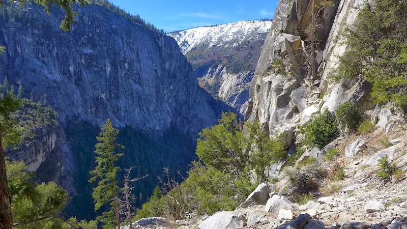
If you are still interested, then the question for this thread is how to get non-climbers up there without experiencing very much vertical exposure, and without exhaustion. The most commonly used method is to follow the climbers' route past Lost Lake, then stay left at the climbers' uphill turnoff, and go downhill a bit, until you get to the nasty, steep, loose, uphill gullies that lead up to the nasty bushwhack that leads up to the steep loose sand that leads you to the Diving Board. Don't worry about finding cairns: They are everywhere, leading in all directions.
http://yosemitenews.info/forum/read.php?3,54286,54300#msg-54300

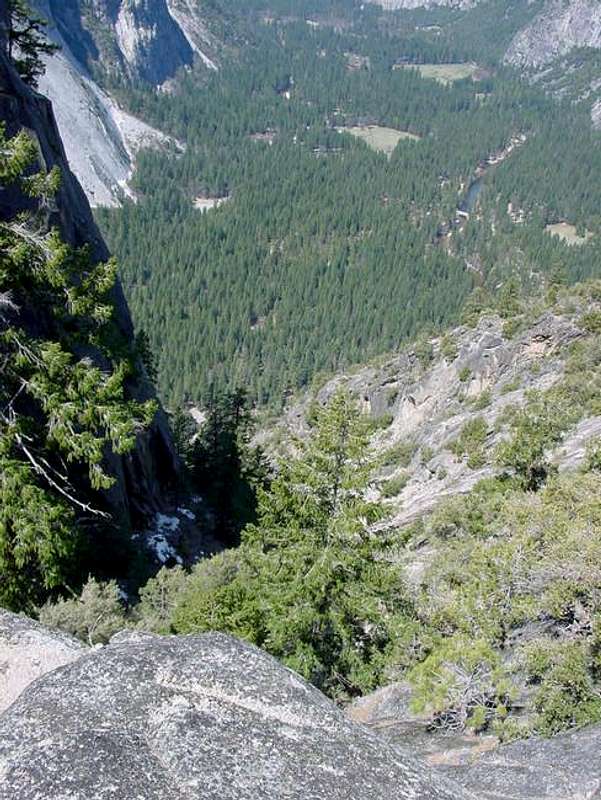
People justly hated that bushwhack. But I haven't done that route since before some climbers left a fire going at the bivouac site at the base of the Snake Dike climb less than a decade ago. That burned much of the grove of trees there and most of the underbrush.


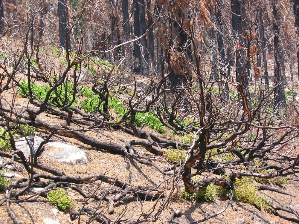
Some people say it's much better there right now, at least until that stuff grows back. You can get to those gullies and that brush from the Lost Lake trail or up from the Emerald Pool.

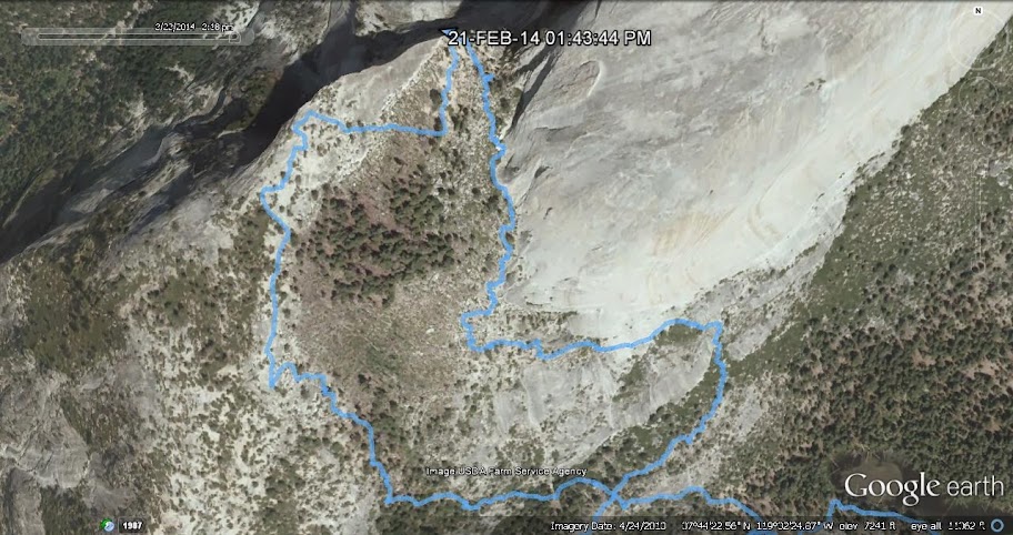
AmostThere posted a gps track below the photos at this link that shows both variations:
http://yosemitenews.info/forum/read.php?3,65836,65866#msg-65866


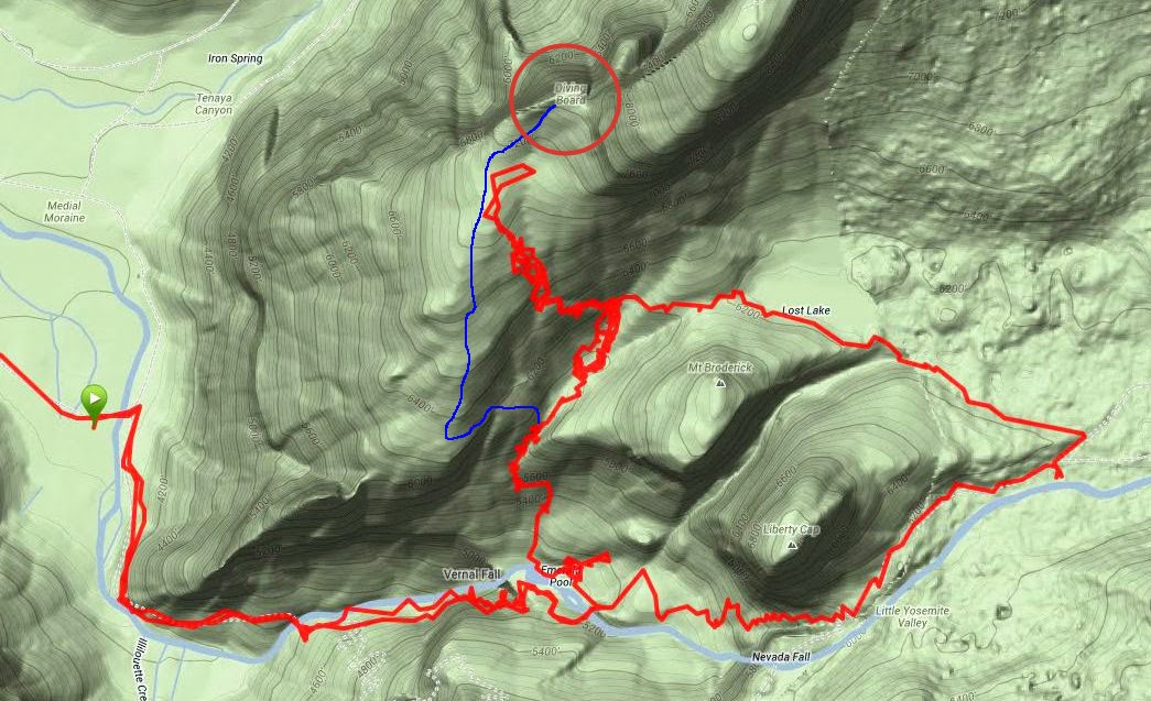
This shows what Chick-on calls "the brush route" pretty well. You can either come up from the Emerald Pool or take the climbers' trail behind Liberty Cap via Lost Lake. Last time, my buddy and I went up the cleft between Broderick and Liberty Cap, but once you are at Lost Lake it's all the same. Then he went up to scout the climbers' route to Snake Dike and I went exploring off to the west. I have drawn in blue a free-hand version of my usual preferred route. It is the same as the Emerald Pool route shown above, until you get to where I head up and then onto a ledge westbound to the bare ridge overlooking Yosemite Valley. From there on up, it's all scenic and open until you get to the last bit. Then you get to choose between safe sand or a more exposed rock walk to the top.

The wiggles above are because gps receivers don't do well in cliffs that reflect the signals.

Chick-on has sent me a gps trace of his trip to the Diving Board last weekend. Here it is in Google Earth. Note that the usual vertical exaggeration is turned off. It is exactly as steep as it looks.


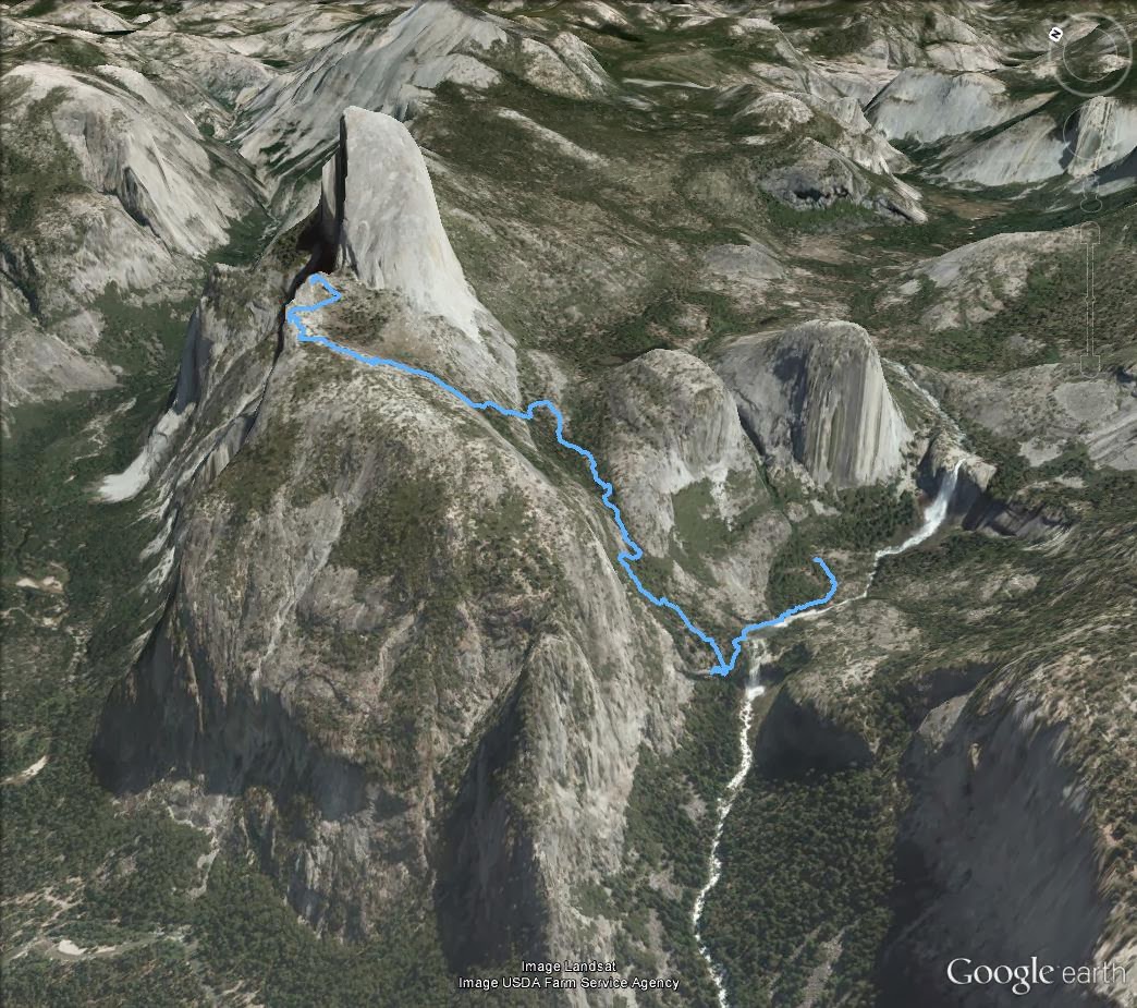
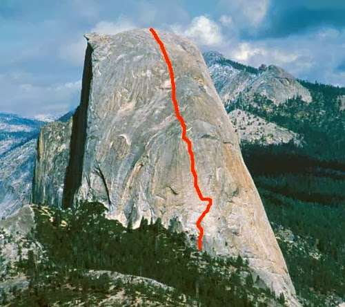
I have also sketched in my preferred route on this view from the side.


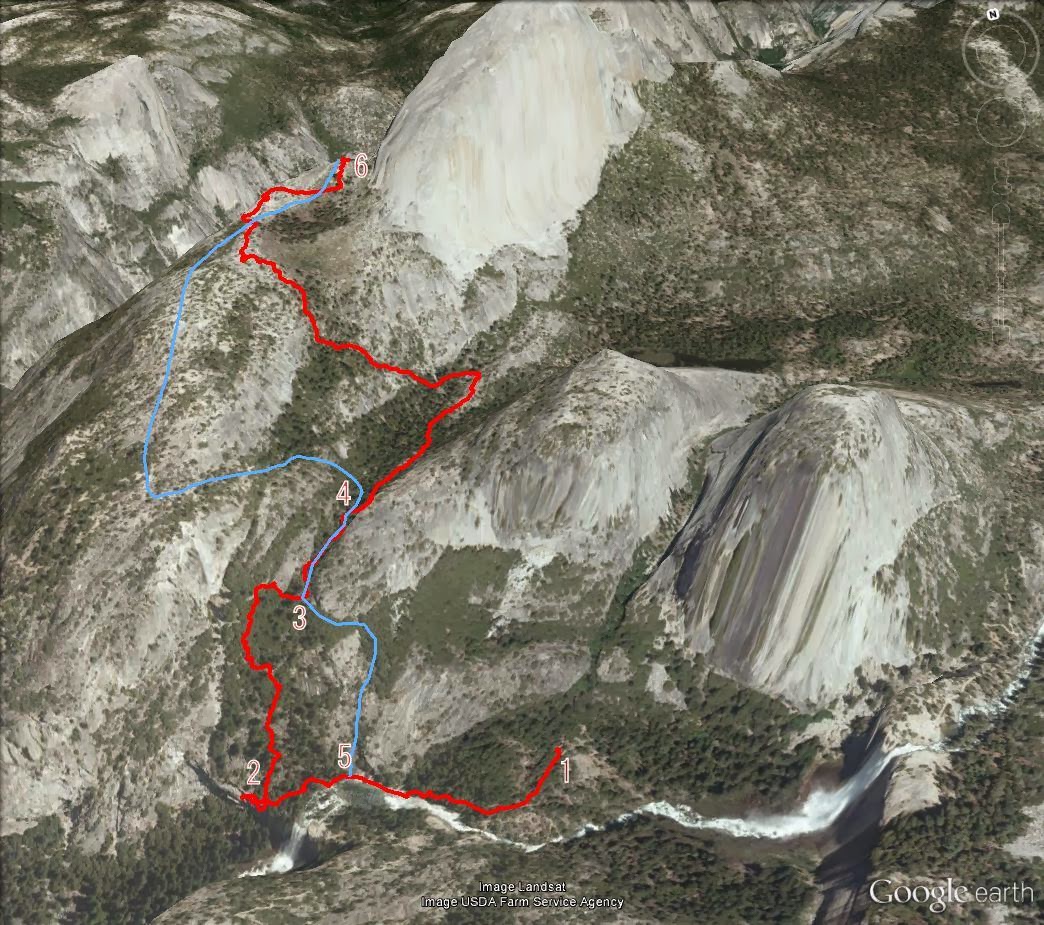
Here's what's going on in this view: Chick-on was tracing out the old Anderson Trail from 1 (the site of Snow's Hotel) to 2 (where Anderson gave up). See
http://yosemitenews.info/forum/read.php?3,72638
He then went up the wooded hillside until it got seriously steep, at which point he went over to the usual route at 3.

Here are comments on my preferred route: 5 is where one usually leaves the Emerald Pool. It is easy going on open, low angle slick rock. It is just west of where the Anderson Trail was forced right down to the river. If that spot is under water, then one should back up a bit, head up the hill, and find a short friction scramble going west over the rib of rock there. Beginners will accept a hand line in order to do this with confidence. After that you are again on low angle slick rock until you can meet up with the regular route.

At 3, you skirt a cliff and enter a gully. Just beyond that point there is a rib of rock running down the gully. Take the left hand (west) side to avoid a difficult spot.

At 4, you turn up the hill. As far as I can tell, it is at N37.733°, W119.5419°. It is steep, but not exposed, and not nearly as steep as it is farther to the east. When you come up under a slick rock cliff, you have a choice. You can follow along the base of the cliff up to the right, which is easy terrain and will put you in the woods leading to the top. But last time I tried it there was serious brush whacking to do in there. It's probably better to follow the cliff base to the left, which will take you along a ledge until it opens up at the ridge line. Great views and all that. Above there, the only obstacles are a couple of ten foot steps on the ridge, which are easily passed on the right (east) side.

Be careful. Don't get lost coming back down. For worry wart friends, I actually have some orange water-soluble marker tape that you can tie to a branch. If you miss removing it on the way back down, it will dissolve in the next rain. It's better than relying on ducks, which are everywhere up there.


Edited 3 time(s). Last edit at 03/01/2014 07:02PM by wherever.
avatar Re: Easiest route to the Diving Board
March 01, 2014 01:31AM
Thank you for posting this detailed look of ways up to the Diving Board. As usual, it's very informative! Thank you for taking the time to write it all up.

.
avatar Re: Easiest route to the Diving Board
March 01, 2014 08:03AM
Love it. Just to correct one thing. Wasn't trying to pull wool over anyone's eyeballz.
But I went up gully... then up slab route.. I came back down via shrub route...
and then thru liberty cap / brod gully after playing around atop Broderick.
Was showing the EZ way up w/ no exposure. (although easiest is simply from LYV then up shrubby route)
(I stitched 2 gpx files together)
As such:

Both routes were stellar. The left route had zero shrub imo.
The right one ... right next to Z dome... a bit of this and that... but it's worth it.

Here's my Ansel Faux Toe:


If you don't have wide angle... then just take a few and stitch them with uSoft ICE.

Have another route in mind... similar to Fireplace Bluff route. (hint: RIGHT next to cliffs are USUALLY pretty clear)
Will do it soon and let you guys know what I see.

Have fun


Chick-on is looking at you!
Re: Easiest route to the Diving Board
March 01, 2014 08:46AM
Quote
chick-on
Both routes were stellar. The left route had zero shrub imo.
The right one ... right next to Z dome... a bit of this and that... but it's worth it.

Well, you've been there more recently than I have. Don't forget, this is the end of a very dry February. All the bushes than can drop leaves have done so.

It might not be as great when everything is leafed out...
Re: Easiest route to the Diving Board
March 01, 2014 04:30PM
I've been hoping to fine another "off the map" hike in the Valley area, and this looks
like an amazing one. There are so many links, photos and other info about the
Diving Board in this forum, my head is spinning.

Thanks again to all the heavyweights who contribute so mightily to this
board. You make it possible for the occasional park visitor like myself
to get more out of our trips. Titans of the trail, that's what you are.
avatar Re: Easiest route to the Diving Board
March 12, 2014 07:16AM
Quote
chick-on
Have another route in mind... similar to Fireplace Bluff route. (hint: RIGHT next to cliffs are USUALLY pretty clear)
Will do it soon and let you guys know what I see.
Phone never rang so off I went last weekend to give it a go. It's do-able... wink
Here's the big picture with wherever route in dots... and cliff route in solid:


track directly from gps:


up that-a-way (note the slab off the cliff there)


some way up


shrapnel area (Clark Pt. over yonder)


the slab (it's HUGE)


you'll be happy when u get here


most rest of way you'll almost get tired of seeing Nevada


have fun (and I didn't say to do it) (it's ridiculously steep in some sections... rec. uphill only) (and maybe no backpack)


Chick-on is looking at you!
Re: Easiest route to the Diving Board
March 12, 2014 01:31PM
Quote
chick-on
...have fun (and I didn't say to do it) (it's ridiculously steep in some sections... rec. uphill only) (and maybe no backpack)

Awesome! Thanks. I'm jealous.

Note for those who don't know Chick-on: His idea of ridiculously steep is usually understated.

You'll notice that he didn't recommend this ledge as the easiest route to the Diving Board. However, after LeConte Gully, it has to be the shortest from the valley.

Once he got up onto the ridge and joined up with my preferred route, even Chick-on expressed fatigue with the fabulous views. This really is one of my favorite places.
avatar Re: Easiest route to the Diving Board
March 12, 2014 08:41PM
Quote
wherever

Note for those who don't know Chick-on: His idea of ridiculously steep is usually understated.

Bless his heart, all of his descriptions about various degrees of difficulties tend to be very understated for us mere mortals. I've learned that over the years! But I've also learned to adjust my expectations. For him, it's just a lot easier than the rest of us. That's just fine with me. Love all the effort he puts into his informative trip reports and photos.


Quote
chick-on

Phone never rang so off I went last weekend to give it a go. It's do-able... wink
Here's the big picture with wherever route in dots... and cliff route in solid...

Just want to thank you (and wherever) for posting these photos, especially the photos with the routes drawn in. Makes it very easy to visually where one needs to go if they want to do the various routes.

So helpful. Much appreciated!

.
avatar Re: Easiest route to the Diving Board
March 13, 2014 07:29AM
That's pretty funny. I think I'm pretty realistic with advice on difficulties and whatnot.
I don't think, at least iirc, that I've said stuff was easy. I've said things were do-able.
Actually it's a big reason I've given up on all other forums. Seems everyone either
says "can't be done" or "easy" . I rarely agree. And I don't throw newbs off the trail.
That one I really love. Never been to the park before? First time backpacking?
Hey, why not go xcountry and up Mt. Clark? Piece of cake. Only 2 tents away.
You've prob. heard me say it 100 times... "Haven't been in the area? Then do the trail."
Now if you want to go offtrail.... Feed ME!


Chick-on is looking at you!
avatar Re: Easiest route to the Diving Board
March 13, 2014 09:27AM
Don't worry. Not trying to give you a hard time. It's all good, always love your advice and directions.

It's just something for others to keep in mind when reading your posts that not to presume when you say something is doable, that it translates to being easy (or only with moderate of difficulty). It's just means that it can be done (though with greater difficulty for some (with intermediate or less hiking ability) versus others (with advanced, super human, or super chick-on) hiking ability). That's all.

.
Re: Easiest route to the Diving Board
March 13, 2014 10:02AM
Quote
chick-on
That's pretty funny. I think I'm pretty realistic with advice on difficulties and whatnot.

My apologies. I never meant to criticize your comments. They have always been dead on for me. I was merely trying to make sure that we don't entice the unprepared into bushwhacks that are beyond their ability...

On a totally different note: The Diving Board is one of those places where you can wander off route on the way back down and find yourself in steeper or looser terrain than you came up. A compass isn't much help....you can always see the surrounding landmarks, and you probably aren't more than a hundred yards off, in one direction or the other. You just have to be willing to keep your head and backtrack when appropriate. A gps is good, while the batteries last, but it still pays to look behind you on the way up and memorize a few landmarks. [end of obligatory warning]
avatar Re: Easiest route to the Diving Board
March 13, 2014 01:25PM
I wasn't offended or otherwise w/r to any of the comments either of you guys made.


Chick-on is looking at you!
Re: Easiest route to the Diving Board
March 13, 2014 01:51PM
Quote
wherever
Note for those who don't know Chick-on: His idea of ridiculously steep is usually understated.

I remember struggling to climb the final short "ramp" of the Indian Canyon "trail"--it was so steep that I had to grab onto branches or rocks or whatever I could find to keep from sliding downhill. Why was I there? Because I had read one of wherever or chick-on's reports of this hike.

So if either of them says it's steep, expect steep.

But it will be worth it!
Re: Easiest route to the Diving Board
March 13, 2014 02:40PM
Quote
basilbop
I remember struggling to climb the final short "ramp" of the Indian Canyon "trail"--it was so steep that I had to grab onto branches or rocks or whatever I could find to keep from sliding downhill. Why was I there? Because I had read one of wherever or chick-on's reports of this hike.

So if either of them says it's steep, expect steep.

But it will be worth it!

That trail is worth it. That particular spot is just dirt at the critical angle, with some rocks mixed in. Short and steep and in the open. But the actual trail had barely visible switchbacks in the woods to the right of the open dirt area that you went up. The trail there is sort of a jungle gym of small trees. It's just a question of which bush you want to whack....
Re: Easiest route to the Diving Board
March 30, 2014 02:42PM
One more comment about "easiest". My hiking buddy was up there on Friday. It was the last nice weather before a big storm was scheduled to blow in. He wanted to check out the bivouac situation at the base of the Snake Dike climb, in preparation for doing it later this Spring. He took the Mist Trail and the usual trail around to Lost Lake.

It took three hours to get from Happy Isles to the saddle past Lost Lake, then was slowed down as he got onto the slick rock of the climbers' trail. The slick rock itself was mostly clear, but above that he encountered ice and melting snow and just generally bad footing
.
The actual Diving Board was clear of snow, being exposed in the sun and wind. But any vegetation was accompanied by melting snow.

He then set off to descend by my preferred route. Which he has done with me, but while never route finding it himself. And never while the surfaces were wet and partly frozen. Thus we experience the joy of modern communications. At about the 6450 foot level, he was having route difficulties. The west end of the descent ledge was not obvious, and he got into some thick bushes. Off the route, clearly. It was especially not obvious that the correct ledge would be forthcoming, and there were plenty of cliffs below. So he called me on his cell phone (I was home with an infection). The answer is, yes, you do need to find a path through that brush to the 6300 foot level, where the ledge miraculously appears (going left).

So he did, and it was. The moral here, which I sort of knew, is that it is a lot easier to find your way down a convex mountain where it is hard to see things below you, if you have first come up that way.

The other thing that this trip confirmed is the difficulty of using the Anderson Trail when it is wet with a film of melt water and greasy with algae. He lost his footing several times, and ending up on hands and knees in the edge of the Silver Apron. Fortunately, the Spring flood in not in progress, so all he suffered was wet socks. As I said above in this thread, be very careful of Anderson's path along the Silver Apron when the Merced is raging and full of water, unless you use a hand line for safety. The wet slick rock is slippery, and the grassy veneer alongside it could break loose.


Edited 1 time(s). Last edit at 03/31/2014 08:41AM by wherever.
Re: Easiest route to the Diving Board
August 18, 2014 11:01AM
With a trip to Yosemite now planned, (13 days and counting) I'm seeking
advice for a couple questions about this Diving Board hike. This thread
shows several possible routes to the spot, but is there an easiest way
to get AWAY from the Diving Board? (other than the obvious, giant
leap for mankind method)

Also, the possibility of combining a hike to Sierra Pt. and the Diving Board
via the LeConte Gully route is intriguing, but as the photo on this thread
suggests, the gully route looks like mountain goat country. So, is it possible/advisable
to try to reach the Diving Board via this gulley?

I appreciate the knowledge/expertise/advice of anyone who has experience
with this subject.
avatar Re: Easiest route to the Diving Board
August 19, 2014 11:11AM
It's not advisable. Unless you want to climb LeConte Gully.. and that is your goal.
If your goal is Diving Board... then take one way up... and another down.
Rec. climbers route up... and walk the ridge down... and then from there to the "brush gully".


Chick-on is looking at you!
Re: Easiest route to the Diving Board
March 01, 2014 07:49PM
Thank you all again for great research. What is the route and distance (in time) between the Diving Board and Snake Dike? (or am I missing something obvious)
Re: Easiest route to the Diving Board
March 02, 2014 10:37AM
Quote
chicagocwright
Thank you all again for great research. What is the route and distance (in time) between the Diving Board and Snake Dike? (or am I missing something obvious)

The Snake Dike climb (dike is a ribbon-like igneous intrusion in geology-speak) is the most popular climb on Half Dome. There are 13 climbers in this photo off the web:

It's a quarter of a mile and a couple hundred vertical feet from the Diving Board. I haven't been over there since the fire, but it used to take about 15 minutes in the downhill direction. The use trails will all have changed, but you can always see where you need to go. Or, on a warm sunny day, you can look for the mob of climbers....


http://images.summitpost.org/original/7445.jpg

This is a well-known way to get around the Half Dome cables permit system.


Edited 4 time(s). Last edit at 03/02/2014 01:41PM by wherever.
Re: Easiest route to the Diving Board
March 03, 2014 10:34AM
Thank you much again. That answers my question that Snake Dike really isn't close enough to the Diving Board to make the Diving Board an automatic must-do on a Snake Dike climb. After hauling the climbing equipment to the base of the climb, I'm betting you would burn at least an hour to get to the Diving Board and back. I'd actually like to sleep Chick-On style at the Diving Board and make the climb first thing in the morning.
Re: Easiest route to the Diving Board
March 02, 2014 01:28PM
I always wondered if there was a route up from the emerald pool. good stuff, thanks.
avatar Re: Easiest route to the Diving Board
March 02, 2014 10:58PM
Ansel Adam's route to the Diving Board supposedly started near Happy Isles going up LeConte's Gully. From a 1998 article in Spot Magazine:

“We came up LeConte Gully, Ansel's route, under the north face of Grizzly Peak, up from Happy Isles, up out of Camp Curry to climb to the Diving Board. The Board is a hanging cornice on the west edge of Half Dome. It is the spot where Ansel took his remarkable picture, Monolith, the Face of Half Dome. From my desk in Texas or on a topo map by fingertip, it seems a doable day climb. But an hour ago we abandoned our second straight attempt, this time only 500 verti­cal feet and a quarter mile short.”

— Robert Langham (a former Ansel Adam's assistant)

http://spot.hcponline.org/pages/the_diving_board_995.asp


.
Re: Easiest route to the Diving Board
March 03, 2014 02:36AM
Quote
plawrence
Ansel Adam's route to the Diving Board supposedly started near Happy Isles going up LeConte's Gully. From a 1998 article in Spot Magazine:

“We came up LeConte Gully, Ansel's route, under the north face of Grizzly Peak, up from Happy Isles, up out of Camp Curry to climb to the Diving Board. The Board is a hanging cornice on the west edge of Half Dome. It is the spot where Ansel took his remarkable picture, Monolith, the Face of Half Dome. From my desk in Texas or on a topo map by fingertip, it seems a doable day climb. But an hour ago we abandoned our second straight attempt, this time only 500 verti­cal feet and a quarter mile short.”

— Robert Langham (a former Ansel Adam's assistant)

http://spot.hcponline.org/pages/the_diving_board_995.asp

.

Yes, it's unquestionably the shortest route from the Valley. It's in Roper's climbing guide, and is mentioned a couple of times in this thread:
http://yosemitenews.info/forum/read.php?3,44869,45073#msg-45073

But the brief class four section puts it out of the "easiest" category. Also, the few references that I have seen to it in recent years suggest that both the brush and the loose rocks have changed over the years, and I haven't seen an up-to-date route description for a long time....
Re: Easiest route to the Diving Board
March 03, 2014 06:03AM
There is also an active mountain lion den upslope toward Grizzly Peak. That was in a trip report by some climbers I read a couple years back. The cat is probably still there... it's a great place to get away from tourists.
Re: Easiest route to the Diving Board
March 11, 2014 09:04PM
Quote
AlmostThere
There is also an active mountain lion den upslope toward Grizzly Peak. That was in a trip report by some climbers I read a couple years back. The cat is probably still there... it's a great place to get away from tourists.

I read the same report somewhere. I also heard that due to a rock slide its pretty much a class 5 route now
avatar Re: Easiest route to the Diving Board
March 12, 2014 07:06AM
Right from the HI Parking Lot you get a great view of LeConte Gully upper reaches:


And... also... both the Visor and Diving Board area ... (and prob. why it is called Diving Board)


Diving Board proper is the 45 angled rock up there though... at least that is what I always thought.


Chick-on is looking at you!
avatar Re: Easiest route to the Diving Board
March 03, 2014 03:27AM
Does LeConte Gully start somewhere off of the trail up to Sierra Point?
Re: Easiest route to the Diving Board
March 03, 2014 05:48AM
Quote
qumqats
Does LeConte Gully start somewhere off of the trail up to Sierra Point?

Yes, it does. You can find some discussion of where the Gully is and what it looks like here.


Edited 1 time(s). Last edit at 03/03/2014 05:51AM by DavidK42.
Re: Easiest route to the Diving Board
March 07, 2014 01:05PM
Quote
DavidK42
Quote
qumqats
Does LeConte Gully start somewhere off of the trail up to Sierra Point?

Yes, it does. You can find some discussion of where the Gully is and what it looks like here.

There is a wonderful, but very short, video of Ansel Adams and friends going up Le Conte Gully with his gigantic camera and tripod.
http://www.sfmoma.org/explore/multimedia/videos/114

Take a good look at their packs and shoes about 45 seconds into the video. Chick-on and the rest can brag about their wonderful new packs, but those guys were heroes, doing what they did with what they had.

It's also clear that they used simple belaying without all of our modern hardware for relatively easy climbs like this one.

The photo of Nevada Falls about 20 seconds into the video is from the saddle behind Grizzly Peak, as this Google Earth view of Le Conte Gully shows.


A check of photos from Sierra Point and elsewhere confirm that the view in the video is not from Sierra Point or elsewhere else. However, if the time sequence is right, the photographer then went back to film the last of the party topping out of the gully. Here are a couple photos of the gully from the links that DavidK42 mentioned.


And finally, here is a stunning photo of a tent on the Diving Board by Sheldon Neill as posted on HikeHalfDome:


It makes you want to dash right up there.


Edited 3 time(s). Last edit at 03/07/2014 01:13PM by wherever.
avatar Re: Easiest route to the Diving Board
March 07, 2014 03:02PM
Couple of mine:


And yeah, the really old photos and whatnot are awesome. (but I'll take todays tech gear) tongue sticking out smiley


Chick-on is looking at you!
Re: Easiest route to the Diving Board
March 07, 2014 03:58PM
That second shot is something special. Really like that angle.
Re: Easiest route to the Diving Board
March 07, 2014 04:02PM
Quote
Torero14
That second shot is something special. Really like that angle.

Right. Here's where the 3D effect would really shine in showing the amphitheater of Vernal Falls.

Of course, it's not at all trivial to get there....
Re: Easiest route to the Diving Board
March 07, 2014 01:17PM
Thx for all the Boarding School tips. Might be heading up that way in a month or so.
Re: Easiest route to the Diving Board
August 21, 2016 09:32AM
Hi Everyone,

It's been awhile since anyone has posted in this thread, but I just wanted to pop in and personally thank Chick-on and Wherever for posting their routes to the Diving Board. I traced both of their routes on google earth and loaded the map onto Gaia GPS and that's what my buddy and I used two days ago to make it to the Diving Board for sunset. We took the Emerald Pool route up and the regular bush route back down.

Just a couple of key points:

1) Wherever mentioned that one of the benefits in taking the route up from Emerald Pool was that it might get "non-climbers" up to the top with a minimum of exposure and exhaustion. This route definitely avoids the type of exposure you would encounter if you were taking the upper route from going around the corner at Lost Lake and heading up. The gps definitely helped us make our way up that gully as there was no clear trail. Whereas I didn't find any part of this trail particularly "easy", at least I wasn't worried about falling off a mountain on the way up. But it was definitely pretty steep in spots and fairly bushy.

2) Chick-On mentioned that it probably wouldn't be ideal to take a heavy backpack up this route. Mine was approaching 30 pounds between my camera gear (Nikon D750 and three lenses, two of which were on the heavy side), tripod, and water. I cannot emphasize strongly enough that if you are a 54 year old who loves to hike but doesn't really CLIMB every other weekend that it would definitely be a good idea to leave the heavier stuff at home. This route would have been incredibly easier if I had just been carrying a small camera and the water, i.e. 30 pounds was a bad idea. It was indeed very steep in some places and the loose debris (tons of leaves on some of the steeper sections) just made it that much more difficult. Once we were toward the upper part of that gully, things leveled out and became much easier until we met up with the regular trail at which point things became nearly impossible, i.e. crazy steep. I almost gave up as I was already exhausted when we hit the junction between the gully and the normal bush route, but I pushed on. The new boots weren't entirely broken in and now I was dealing with some good sized blisters on the soles of my feet. To give you an idea of how slow I was moving, we set off at around 10:30 AM from the parking lot and didn't make it to the diving board until 6:30. But hey. At least I made it up there. I made it back to the trailhead, wincing on the blisters at 3:30 AM having taken the normal bush route out around Lost Lake.

3) I think both of these two mentioned, at some point, that you shouldn't skimp on the water. Between the dry air and the clouds of dust that you will encounter in sections, I burned through those three liters pretty quickly and was very happy to find a creek on the way back around Lost Lake to use my filter on. I was thinking about camping and making this a two day trek if I ever try this again in the future, but water will still be an issue. Unless I'm missing something, the only water source in August is back at the river, or at the small creek we found on the trail to lost lake, and there's no guarantee that creek will still be flowing late in the Summer. I felt like I wanted to drink GALLONS of water on the way out of there, but I would have been in a lot more trouble if I hadn't brought the filter. It looked like the only water source for camping was the river, assuming Lost Lake is dry.

4) GPS was a life saver for us. Don't forget the backup battery for your phone if you are using Gaia. For those who haven't used Gaia, I was surprised to learn that it will continue to track you even when you are out of coverage. Don't forget to download your selected area of hiking into your phone before you leave or it won't do you much good.

5) If you stay for sunset, keep in mind that the cairns are MUCH harder to see in the dark. Even with the gps, we had to double back a couple of times as those turns are just so hard to see in the dark and there's not much of a "trail" to work with in several sections.


Again, big thanks to Chick-on and Wherever. We'd probably still be up there wandering around if not for your routes posted above.


Edited 4 time(s). Last edit at 08/21/2016 09:57AM by MtSacProf.
Re: Easiest route to the Diving Board
August 21, 2016 10:23AM
Nice job on that route, my son and I attempted it in July but we got a late start and our turn around time no matter what was 5:30. I didn't have a GPS with me and so we wasted time trying to find our way through the gully. So we eventually turned around. I know now the way through and next time shouldn't take as long.

Would love to see your evening pictures from the Diving Board. Please post them up.
Re: Easiest route to the Diving Board
August 28, 2016 06:29PM
Thanks for so many great comments and messages here.

Over the years, I've made three attempts to get up to the Diving Board. I'm a former climber, but haven't climbed in many years, and don't enjoy significant exposure without being clipped in to something. And yes, I'm now at that "almost senior citizen" age.

I made my first attempt back when I was in my early 40s. Went solo with about 70 lbs. of photo gear (film, medium format) on my back. Bivvied in Little Yosemite Valley off the trail (before permit was required), and was awakened by a bear standing over me at about 2:00 am, under a full moon. Tough getting back to sleep after that. Started up past Liberty Cap, Mt. Broderick, and Lost Lake in the morning, still toting about 55 lbs. of gear and water. Made it up on the shoulder of the backside of Half Dome. A ranger had kindly advised me just to follow the cairns for the route. Of course there are probably a thousand cairns seemingly randomly distributed up there, often place by people with far better climbing skills than mine (and far less weight on their backs). I'd set a 3:00 pm turn around deadline so I wouldn't get stuck up there in the dark, and never even made it around to the west side (Snake Dike) shoulder. Epic experience and exhaustion by the time I got down to Happy Isles that night.

Second attempt was a summer effort with my almost-teenage son about 12 years ago. We decided to do it as a day trip, rather than overnight, and left Happy Isles around 5:00 am. I carried a lightweight rope and a few 'biners, just in case, and pared back to a minimum on the photo gear. Total pack weight this time was probably about 35 lbs. Took the same route past Lost Lake from Little Yosemite Valley, and found our way up to the Diving Board by about 3:00 pm. Great experience (again exhausting, however), and we made it back to Happy Isles by around 10:00 pm. Of course, I still had to drive us back to the bay area that night. Wound up having to pull of the road to nap for 45 minutes at the Altamont Pass, which awakened my son sleeping in the back seat, who demanded to know "why are you stopping, Dad? I want to get home to my bed!"

Fast forward to about three years ago, when my daughter, just graduating from high school, wanted to share in the same adventure her brother had with me years earlier. I wanted to be up on the Diving Board for good sunset light, but didn't like the idea of having to make the descent after dark. So I inquired about getting a wilderness permit to camp up there. The ranger said they didn't allow camping on the Diving Board because of a lack of facilities, but said I could request a permit for a bivvy for the Snake Dike approach, and no one would really care if we happened to spend a few (or more) hours into the evening up at the Diving Board. This permit request was approved, and we managed to do the trip up in a day, and hiked back out the next. There are still some pretty exposed and dicey traverses going across the back side of the dome, which I don't like. We'd been told to start the traverse to the left as low as possible after Lost Lake, but couldn't find a reasonably clear route through all the brush until we got well above it and into the cairn maze. I'd love to do this ascent someday with someone who knows a better, lesser exposed route, although I question how many more years I'll have to be able to push this hard. It sure is a lot easier with less weight on your back, though. smiling smiley

The Diving Board is perhaps the most spectacular location one can get to in Yosemite without technical rock skills. The work needed to get there makes it seem that much more special.

My daughter is graduating from college next June, and has already asked if we can climb Half Dome via the cable route to celebrate. Since I've never been to the summit, it seems like this is a good time to do it. Now, I just have to navigate the permit process... sad smiley


Edited 2 time(s). Last edit at 08/28/2016 06:40PM by ScottH.
Re: Easiest route to the Diving Board
August 28, 2016 09:29PM
Absolutely incredible sunset image of HD from the Diving Board. That alone would make any serious landscape photographer envious. Kudos to your efforts and dedication to get this accomplished. Thank you for sharing.
Re: Easiest route to the Diving Board
August 29, 2016 04:01PM
If this photo isn't the single greatest to ever grace this forum,
it is certainly on the All-Star team. Very well done.
Re: Easiest route to the Diving Board
August 30, 2016 07:28PM
Cmon4day - Thanks for the encouragement. I'll post mine here, but Scott's blows mine clean out of the water. He had some GORGEOUS light, and our sunset clouded up right at game time. We had a bit of color in the sky, but we were hoping for something more like Scott's. I'm not sure when Scott made his trips up, but I'm guessing that photo might have been taken earlier in the Summer, but I could obviously be wrong. Either way, it just makes me want to crawl back up there for another attempt. Scott really hit the jackpot on that one.

Looking closer, I think I see some snow on the diving board. Scott - If you are still around, I'd love to know when that was taken. I also feel like a weenie after hearing about your 70 pounds of gear and the bear!

To add insult to injury, my buddy and I LEFT my 24-70 lens, a tripod and most of my food and water as I simply wanted to make it to the top and I knew that wasn't going to happen with my measly 30 pounds. I was toast after that climb and I just didn't have it in me. I made it to the top once I jettisoned a good chunk of my gear, but I was expecting to grab it on the way down. Unfortunately, we hit the trail in a different spot on the way down in the dark and I had to leave about $2500 worth of gear lying in a pile somewhere behind me. I headed back up there a few days later with just enough water and food to make the climb and made it back up in just over 4 hours, but it was MUCH cooler at 4 AM when I left and I took the longer route up around Lost Lake on my way in instead of the short cut up from Emerald Pool. Thank God I found my stuff lying exactly where I had left it. It sure is easier to find your way around up there in the daytime!

Anyway....here's one of my shots taken as the sky lit up behind us casting a bit of alpenglow after sunset, just before we headed down:


Edited 11 time(s). Last edit at 08/30/2016 07:59PM by MtSacProf.
Re: Easiest route to the Diving Board
September 25, 2016 09:37AM
Mt SacProf,

Don't sell yourself short. That is an amazing photograph. Especially considering the hard work and perseverance to get there. Well deserved shot and one most photographers would be proud of.

Scott, that is an amazing 360 from Yosemite Falls. Another good spot would be up at Sierra Point.
Re: Easiest route to the Diving Board
September 23, 2016 12:58PM
Thank you all for your kind words about my photo. I'm flattered given the caliber of climbers and outdoor folk here. I remain in awe of some of the locations and routes you guys describe on these forums.

To answer MtSacProf, the photo was taken mid-June, about three years ago. There was no snow that we could see, and I suspect that the areas that look a bit like snow are simply light granite or sandy patches.

I'm now working on a series of 360-degree panoramic VR images of various interesting locations in Yosemite. I'd welcome suggestions from you all (keeping in mind that my technical climbing days are mostly behind me). smiling smiley

To see a couple of examples from Yosemite Falls, shot earlier this summer, go to:
http://www.vrphotography.com/yosemitefalls/

Regards,


Scott Highton
Author, Virtual Reality Photography
Web: http://www.vrphotography.com
E-mail: scott@highton.com
Sorry, only registered users may post in this forum.

Click here to login