Welcome! Log In Create A New Profile Recent Posts
Half Dome from the Four Mile Trail to Glacier Point, Yosemite National Park

The Moon is Waxing Gibbous (57% of Full)


Advanced

All Wet and PO'd in South Fork

All posts are those of the individual authors and the owner of this site does not endorse them. Content should be considered opinion and not fact until verified independently.

All Wet and PO'd in South Fork
January 23, 2018 07:06PM
The original plan for the MLK weekend was for the Great Pink one and me to do an overnight trip to El Cap while JKW continued her recovery. Not surprisingly, there was a last minute "vadering" of the trip. Instead we would do a long day hike down the South Fork of the Merced along the prominent trail on the National Geographic map. I had been looking at this trail, too, and this alternative itinerary would let us have dinner with JKW, so I was game.

On the drive to our trailhead, we stopped to look down on the fog that we had been in not too long ago.


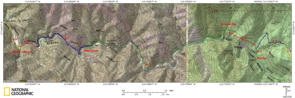
Instead of starting at the official Bishop Creek trailhead, we did a short cross-country bushwhack from the Wawona Road that had been the subject of a previous boundary marker search. When we did hit the trail, it was very faint despite being on so many maps.


Although there had been signs of previous logging here and there, one tree seemed to have been cut down solely to provide a way to cross a side stream.


Between occasional flagging tape and a fairly well-trod path, the trail seemed to get some use. We dropped down to the first junction (with the Rush Creek/Iron Creek trail), which was unsigned.


From this unsigned junction, the trail climbed a bit to go over a spur. At the top of the spur, we lost the trail. Worse, the area was quite brushy and infested with poison oak. We knew where the trail generally went and headed down the ridge, crossed a stream, thrashed around some more brush, and headed for a low saddle where the trail would have to be again.

We were making slow progress, and were considering turning back, but halfway down the next hill, we encountered a substantially-built portion of the trail. It clearly hadn't been maintained in years, but it at least had once been a real trail. We followed this to the next stream, where we found an old sign for "Grapevine Camp".


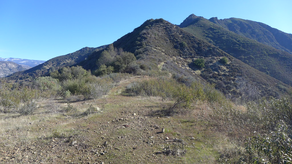
The trail disappeared past Grapevine, but at the top of a nearly-dry waterfall, we could see the trail continuing around a grassy, mostly open hillside. At this point we were more or less committed to heading all the way to Savage's Trading Post.


The well-built trail stayed generally high above the river, and we could usually trace its route along the canyon wall ahead of us.


Below us, the river was a series of cascades, water slides, and the occasional waterfall.


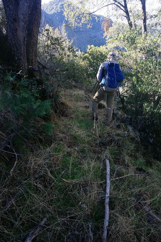
Unfortunately the trail did occasionally pass through areas with more brush, shrub, and poison oak to dodge.


Fortunately, these sections were not too long, and were punctuated with open sections that allowed us to make decent progress.


At one point the trail dropped down to the river level near a nice rocky section--or, at least we thought it was the trail. While we did find some barbed wire here, we were not on the main trail and had to climb up a steep slope to get back on it. It had been nice to be near the river for a few moments, however.


The trail was quite narrow in the open sections, and the side-hilling was a bit tedious. And, despite the fact we were heading down river, we were doing a fair amount of climbing and dropping as the trail navigated the intricate terrain of the canyon.


We didn't (and still don't) know the history of the trail, but it's clear that someone once put a lot of effort into constructing it. Other than being overgrown in places, it is still in good shape and with some maintenance could be returned to good form.


The temperature was quite mild, and the still-yellow grasses were more reminiscent of late spring or summer and not the middle of winter.


Apparently the Great Pink One was not checking our progress--he didn't want to know how little progress we were making. There were enough obstacles that we could not maintain a clear-trail pace, and the short winter days meant that darkness was not too many hours away.


We lost some time looking for where the trail continued across a side stream. We found a small camp here, and curiously a few empty oil bottles. It was doubtful any motor vehicle could have gotten here. Perhaps the oil was for chain saws from long-gone--and very missed--maintenance crews?


At another side stream we refilled on water, then stopped for a quick lunch. We also called JKW and changed our pick-up time from 5:00 to "at least 6:00". We had brought three slices of pizza and a lot of other treats, but after splitting a single slice, we continued along--we knew we were racing the sun, and it was winning.


Eventually the trail dropped to river level again at Peachtree Bar, where we ended up on a rock with several mortar holes.


There seemed to be good camping here, and a nice open meadow a bit down river, but we rushed right through this place. The river was already in shadows.


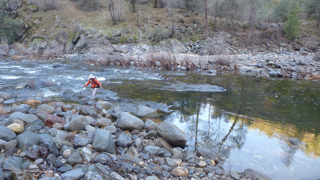
The first river crossing, marked by a simple "Trail" sign with an arrow, was knee-deep, and brisk enough that the water made my trekking poles vibrate. The under-water rocks were round and slippery.


Despite how warm the day had seemed, the water was still cold and reminded us it was winter. My feet were freezing cold by the time I reached the other side, but they warmed up once I took off my water shoes and dried my feet. On each side of the river were two halves of a now-useless cable, although we couldn't figure out how it would have helped us cross the river even intact.


We were now on the south side of the canyon--in the dark, and also in much more lush forest. Poison oak shoots were everywhere. At Snyder Gulch was another mysterious cable; fortunately this side stream could be crossed with a careful rock-hop.


After a bit of a navigational goof, we were at the next junction--this one with a sign. Despite it being almost 5:00, we still had 9 miles to go.


Hite Cove was 4.5 miles away, not 2.

It was impossible to avoid the poison oak shoots in the lush forest the trail wandered though, and it continued to climb up and down, into and out of side gullies. The damp conditions made the trail quite slippery, which limited our progress. Eventually, almost in the dark, we saw another small sign. We were now on the Hite Cove "road."


We were still a few miles from Hite (or rather "Hites"winking smiley Cove, but our path would in theory be much easier from here to Savages. Once on the road, our pace picked up, and we split some apple strudel.

We called JKW again at a marked campsite and advanced our pick up time to 7:30. The final obstacle for us was the second river crossing. We had hoped to be at this crossing before sunset, but it was pitch dark when we arrived at Hite Cove. We stayed on the road until the west end of Hite Cove, where one map suggested the road crossed the river, but there didn't seem to be a safe way across here, so we backtracked to the east end, where the river was wide, calm--and dark. We had no way to gage how deep it was with our headlamps, and after I had my water shoes on, the Pink One was in water well over his waist--but he was mostly to the other side. I quickly followed. The unofficial depth gage was that the water was over the top of his trekking poles.

(A week later, we would revisit this crossing and learn that we crossed maybe 25' too far upstream of a much more shallow area.)

After putting back on dry shoes, we continued walking--we needed to keep moving to stay warm. We had a few false starts locating the trail that leaves Hite Cove, but it was obvious once we were on it.

A bit past the cove we passed some equipment from an old mill and took a few pictures.


From here the trail was mostly easy to follow with our headlamps, and not too much later we were at a reflective sign that indicated we had 3/4 miles to go.


Not far past this sign we saw the lights from the homes and lodgings at Savage's. JKW was on the radio, and she informed us that a warm car and warmer motel room awaited us. After two long showers to clean off any possible poison oak, we had a nice dinner.

Despite the long day and the chilly water crossings, I enjoyed the hike. And, although I had now officially been to Hite Cove, it's like I barely saw it. Another visit would be warranted.


The next day, the Great Pink One and I found two additional boundary markers--the highest numbered ones. He had to return to the Bay Area that day, but on Monday while looking for signs of old trails in the valley I stumbled across 10 unknown (to us) sequoias; a week later, the total would be over 40.

Overall, a very enjoyable weekend, even if we didn't backpack to the top of El Capitan.
Re: All Wet and PO'd in South Fork
January 24, 2018 04:32AM
That fog picture is spooky.
Re: All Wet and PO'd in South Fork
January 24, 2018 06:46AM
Cool report! We did Hite Cove quite a few years ago, later in the spring when the flowers were really nice. Lovely spot.


There is also an old road that runs from Hite Cove straight up over the ridge to Indian Flat--which may also connect to the Pinoche Peak Trail that follows the top of the ridge. The whole area is covered with interesting mining relics


Scary that there isn't more water in the river. It looked like this in April of 2010


Check our our website: http://www.backpackthesierra.com/
Or just read a good mystery novel set in the Sierra; https://www.amazon.com/Danger-Falling-Rocks-Paul-Wagner/dp/0984884963


Edited 1 time(s). Last edit at 01/24/2018 06:53AM by balzaccom.
avatar Re: All Wet and PO'd in South Fork
January 24, 2018 07:13AM
There was plenty of water... smiling smiley


(spring runoff shouldn't be really occurring yet! no?)

We dooz the road too...


Chick-on is looking at you!
Re: All Wet and PO'd in South Fork
April 15, 2018 08:11AM
Those with an interest in revamping this trail, do let me know. In partnership with the SNF and local watershed council, we have 5 trail work days planned.
avatar Re: All Wet and PO'd in South Fork
April 16, 2018 04:38PM
Quote
Explorer10K
Those with an interest in revamping this trail, do let me know. In partnership with the SNF and local watershed council, we have 5 trail work days planned.

What days? And what sections are you planning to revamp?

Area around Grapevine Camp and Peachtree Bar were the most overgrown.

We've also done Pinoche Ridge a couple of times this winter. (and The Incline)

Both a gem. It's a shame that Pinoche Ridge from Indian Flat is impossible... (we tried)

Though we have a lot of fun following old "trails" and thrashing thru the shrub...

Also, anyone know how to contact the owners of "Camp One" ? Kinda a bummer to not
be able to explore the old south incline.
sad smiley


Chick-on is looking at you!
Re: All Wet and PO'd in South Fork
April 16, 2018 04:59PM
It'd be great to have you along. The planned trips are described below:

Trip 1 (May 30 & 31): This outing consists of two independent work days focused on a 3 mile segment of the western end of the South Fork Trail, west of "Stripped Rock." The primary goal of the trip is to repair existing tread. This work will occur on the Hite's Cove Trail" segment- easy access.

Trip 2 (June 11-13): This outing consists of a 3-day 2-night trip focused on a 2.75 mile segment of the eastern end of the South Fork Trail, located between Kistler Cabin Site and Grapevine Camp. The primary goal of the trip is to identify and re-establish tread that has been reclaimed by nature. Most of this work will entail finding and marking the trail. If time allows, we'll scratch out a trail.

Trip 3 (Oct. 12-17): This outing consists of a 5-day 4-night trip focused on a 10 mile mid-section of the South Fork Trail, located between Bishop Creek and Peachtree Bar. The primary goal of the trip is to find, mark, prune and widen the trail corridor of shrubs, enabling future work on the faint but existing tread. Most of the shrubs are gone; it's mostly grass in this section, but there are a few reaches where we'll work. The most challenging of all the outings, but the best opportunity to fish and eat rock lobsters! I've built A LOT of time in this outing so we can explore the multitude of pools in the area!

Trip 4 (Nov. 17-18): This outing consists of a 2-day 1-night trip focused on a 0.5-mile mid-section of the South Fork Trail, east of Devil's Canyon. The primary goal of the trip is to repair the original but forgotten "upper trail," which is located out of the floodway; this work will include pruning and repairing the tread. The location of this segment has already been located, and the work will be quick. Lots of;loose deep soil.

Trip 5 (Dec. 15-17): This outing consists of a 3-day 2-night trip focused on a 2 mile segment of the western end of the South Fork Trail, downstream of Hite's Cove. The primary goal of the trip is to repair existing tread.

Check out a FB page I administer; it'll give you some background info.
"South Fork Merced River Trailblazers"
avatar Re: All Wet and PO'd in South Fork
April 17, 2018 10:51PM
We are intrigued by Trip 3. Maybe it includes east of Peachtree?
Maybe Bishop Creek is same as Kistler? I'm a bit confoozed by the numbers...

Here is our track with annotations... (we did not go to Kistler though, I drew that in)


Please correct any misunderstandings... thank you

Just a note ...
The area east of Peachtree ... enjoyed and thought far superior to Hite Cove ...

I'll assume you've hiked it all.. and know way more than me.

Grapevine was delicious.

Confused by the numbers on your Trip 2...

I did look on facebook. ...

Personally I'm in the mountains literally half or more of the time... so pardon any delays...

On a South Fork note... I'll assume you've done it in Yosemite and have
talked to Yosemite about Snaffle Bit Trail... ???
Horse Thief Canyon is a gem...


Chick-on is looking at you!
Re: All Wet and PO'd in South Fork
April 18, 2018 09:24AM
Kistler and Bishop Creek points are different. By your numbers-map, trip 3 focuses on the 8.7 mile reach, east of Peachtree all the way to the point where the Alder Creek Trail crosses Bishop Creek. That is the trail segment identified for maintenance work. The trip will start at the Wawona Road trailhead at Alder Creek, and end at Savages, however. I've backpacked this route twice, once in mid-Sept and the other in mid-October. Heat is the biggest challenge, not that others are small smiling smiley. But, it could snow in mid-October too- crap-shoot.
The mileage on trip 2 is rough, but will focus on missing trail segments between Kistler and Grapevine. I'm looking forward to this as most of it will entail searching and marking the original trail. Lots of sleuthing to be had.
Thanks for the notes on Snaffle Bit and Horse Thief; I've not been to either.
B
avatar Re: All Wet and PO'd in South Fork
April 18, 2018 10:03AM
Thanks for the info. Of course I screwed up and wrote:
"Maybe it includes east of Peachtree" when I meant
"Maybe it includes west of Peachtree"
Sigh.

Yeah, just couldn't make out the exactitude on account the numbers didn't mesh exactly.

I kinda thought Trip 3 was as you clarified.
In Jan the 1.3 section was extremely nice and in great condition. It only started getting
bad to worse to uh, we gonna be crossing the SF in the dark, near Grapevine (and
a bit beyond).

Anywho, it never snows or rains in Yosemite. smiling smiley So October should be fine. smiling smiley
O, wait, this isn't Yosemite.

Agree on Trip 2. There were Manzanita in the trail. It was well built... So you gonna
need a saw me thinks. Timing on that one is doubtful. Definitely intrigued though.
May go check out ur work between your Trip 2 and 3.

So, yeah, keep us updated. I'm definitely possibly maybe perhaps more than likely
tentatively in on Trip 3. Any chance can just go back out Bishop Crk TH ?
I'm VERY allergic to PO... though.. so... need to prepare accordingly...

This is basilbop's photo of me on the trail east of Grapevine:

As much as we wanted to follow the trail in entirety... daylight was burning...
and we'd have to crawl through some stuff as it was...

O, also... fwiw... The Merced River Trail could use some love...
It's delicious east of Sweetwater. Kind of a shame imo...


Chick-on is looking at you!
Re: All Wet and PO'd in South Fork
April 18, 2018 10:26AM
I'll keep you posted on this and other planned forays into the woods.
Re: All Wet and PO'd in South Fork
April 18, 2018 10:43AM
After doing a bit of research, yes, I've done the Snaffle Bit trail- back in '86 when I worked as a temp for resource management on the "wilderness impact" project. Great times.
B
avatar Re: All Wet and PO'd in South Fork
April 18, 2018 01:48PM
Wondering if you have run into or are working with a "Mr. Williams".
We talked to him for a bit at the Mariposa Museum and History Center.
He was telling us about his work along the South Fork.
From what he said he is now retired but still loves the area.

There also used to be a trail from Canty Meadow down to Peachtree.
We think we spied a bit of it exploring Pinoche Ridge and the mines and
stuff in that area.
You can find it on the 1930 old topos.

If you have any old photos of the works along Pinoche. We'd love to see them.
especially at Canty.

EDIT: been meaning to give shout out to Mariposa Museum and History Center
If you like anything about California history and mining and such ... plunk down
the entrance fee and spend an hour or two ... also outside is a stamp mill.
If you're a fan of Hite Cove. I don't see not loving this museum.
(ok, maybe it's only about the flowers?)


Chick-on is looking at you!


Edited 1 time(s). Last edit at 04/18/2018 01:53PM by chick-on.
Re: All Wet and PO'd in South Fork
April 18, 2018 05:17PM
I'll be chatting with Mr. Williams this Sunday.
I'm familiar with the old Pinoche trail from Peachtree, and traced a bit of it on the ridge between Canty and Pinoche. I'd like to scratch that out to Pinoche someday.
But what really interests me is locating the trails used by the Mariposa Battalion. I've not buying the story of them going up to the meadows and down to Pohono; I think they came in a lot lower. Just a hunch more than anything else.
How do I add photos etc here. Looks like my options are to post to a website first. Yeah?
B
Re: All Wet and PO'd in South Fork
April 18, 2018 07:16PM
Quote
Explorer10K
How do I add photos etc here. Looks like my options are to post to a website first. Yeah?
B

Correct - post to another site and then link to it here.
Which is why the photos in many of the older posts don't show anymore - Google shut down Picasa. angry smiley
avatar Re: All Wet and PO'd in South Fork
April 24, 2018 03:26PM
Quote
Not quite The Geezer, but getting there
Quote
Explorer10K
How do I add photos etc here. Looks like my options are to post to a website first. Yeah?
B

Correct - post to another site and then link to it here.
Which is why the photos in many of the older posts don't show anymore - Google shut down Picasa. angry smiley

Any stuff of mine should still show. The links should still work to the photos. However, the links to albums
need to be redone. If desired in any posts of mine, just ask.

w/r to hosting sites. I've moved to flikr
It's free and easy... unfortunately (probably) they just got bought by Smugmug.
So... we'll see what happens...

Explorer10K ... much thanks for taking on this task. am looking forward to seeing what you do in June.
will probably run down there quick to take a peek ... wish you luck and coolness and hmm...
wealth? happiness? prosperity? smiling smiley

Regards,


Chick-on is looking at you!
Re: All Wet and PO'd in South Fork
April 18, 2018 08:52PM
Quote
Explorer10K
I'm familiar with the old Pinoche trail from Peachtree, and traced a bit of it on the ridge between Canty and Pinoche. I'd like to scratch that out to Pinoche someday.

We were mostly successful in following the Pinoche Ridge trail from the mine access road (3S26) at Canty Meadow to the old logging roads at Cathewood Saddle. (We continued to Yosemite West via the logging roads, but found signs of an old trail on Henness Ridge a few weeks later...) The worst part is just east of Canty Meadow where the trail dodges dense manzanita. By 5445 (west of Pinoche), it's consistently a trail, and is mostly clear to Cathewood. There are signs of fairly recent-ish maintenance--small cut logs and branches. There was also an old cart on the trail and some metal bracket thing west of Pinoche itself.

From the south end 3S26 near the mine/mill area, we could see signs of a well-constructed trail (rockwork and terracing) heading down towards Peachtree via a mostly open ridge. It's probably easiest to access this trail from the flat area below the old assay office.

On a separate note, there is also an obvious old trail heading down the Merced River above the old railroad grade--going at least from Clearing House to the Mountain King mine west of Briceburg. Do you know anything about this? It seems to consistently stay above the railroad, which makes me think it may post-date the railroad--possibly for power or telegraph line maintenance? This wouldn't be the Henness(y) Trail--that was on the south side of the river and went through Hite Cove.
avatar Re: All Wet and PO'd in South Fork
January 24, 2018 07:09AM
I was literally up to my earz in PO.
(I got some on my ear)

Of course favorite part was oak at 45... trail gone...
had to go around or over... and PO decices to
whack whack whack me right in the face.

Good times...

El Cap ... been there... done that... smiling smiley


Feb 2013
https://yosemitenews.info/forum/read.php?3,62959,62959#msg-62959

Apr 2013
https://yosemitenews.info/forum/read.php?3,65293,65293#msg-65293

May 2014
https://yosemitenews.info/forum/read.php?17,74446,74446#msg-74446

Jan 2016
https://yosemitenews.info/forum/read.php?17,83034,83034#msg-83034

Nov 2016
https://yosemitenews.info/forum/read.php?17,86733,86733#msg-86733

To name a few...

smiling smiley


Chick-on is looking at you!
avatar Re: All Wet and PO'd in South Fork
January 24, 2018 08:04AM
Looks pretty sweet, but this isn't going on my list anytime soon..... me and Poison Oak do not get along, it's way too fond of me.

Thanks for the report. Great reading on a cold foggy day.
avatar Re: All Wet and PO'd in South Fork
January 24, 2018 11:33AM
All this off-trail tramping about has me concerned you guys could wind up just like poor old Rollo de Trap (heck, it even looks like Chick-on!).
1940s from the Government Printing Office. Take heed!:
Re: All Wet and PO'd in South Fork
January 24, 2018 11:57AM
Dang guys, hiking in the dark on a relatively old and forgotten trail...you guys are hard-charging adventurers!!! I hate Poison Oak and probably would have turned back much earlier

Thanks for sharing!
Re: All Wet and PO'd in South Fork
January 24, 2018 06:30PM
You have my sympathy about the PO. Ugly stuff. I remember a moderately amusing dance we did one year at Preston Falls, waltzing through it.


Check our our website: http://www.backpackthesierra.com/
Or just read a good mystery novel set in the Sierra; https://www.amazon.com/Danger-Falling-Rocks-Paul-Wagner/dp/0984884963
Re: All Wet and PO'd in South Fork
February 02, 2018 07:34PM
Update: So I received my used copy of "Treasures of the South Fork". Unfortunately, the author had not been able to discover who built the well-constructed South Fork trail, but he guesses the original was based on miners' trails (at least to Peachtree Bar) later improved and extended by the Calvary around 1905. At this time, the SF Merced was the park boundary from about Zip Creek to Wawona. (Boundary marker hunters will know that the southwest boundary was relocated during the 1905 survey, resulting in a situation where several markers were later removed, including #2 and #3 and many unnumbered markers along the river bed.)

Apparently, the cable across our first crossing was broken in the 1980's, having been "disassembled" by the Forest Service. My hunch is that the cable dates back to when Peachtree Bar had mining activity, and it was disassembled for liability reasons. In the 1980s, the author was hoping the Forest Service would install some bridges, but 30 years later it's fair to guess that not only will the trail never receive formal maintenance, the bridges will never be installed. A century before then, two bridges spanned the river near Hite's Cove.

There were some ruins of rock buildings just below Hite's Cove that we now know were part of "Chinatown". A tag on one encroaching tree read: "Remove tree to save wall."

The mill remnants below Hite's Cove are not associated with Hite's original mine; they are from a later project that re-processed the original tailings.


The nearby open, sandy area is what remains of these original tailings.

It seems like the "Treasures of the South Fork" was in part written to advocate for the protection of the South Fork Merced, and specifically to prevent a joint Mariposa-Merced Water District water project that was planned then. As the river now has the "Wild and Scenic" designation, a lack of convenient bridges and some PO and deadfall may be an acceptable alternative to a dam and diversion facilities.

It's an area rich in history and scenery, one that its unmaintained trail does not do justice.


Edited 1 time(s). Last edit at 02/02/2018 07:36PM by basilbop.
Re: All Wet and PO'd in South Fork
April 28, 2018 09:21AM
To tell what you two were doing, had to open up mapper.acme.com then keep switching between topo and satellite. Visible satellite trail often looked faint game trail like or invisible in some areas. One year maybe a couple decades ago tried to hike from STP all the way to HC and even on that more used segment had to turn back due to PO overgrowing the trail. Of course the canyon has seen a lot of fires in historic times that can readily damage unmaintained trails with erosive debris.

You two must be relatively resistant to poison oak. Simply washing off with lots of soap after such a long day touching the stuff would not have been enough for the rest of us. I can be rather gymnastic carefully moving past in the trail PO branches but that only goes so far. Urushiol oil of course is quickly absorbed into skin within a half hour and one has maybe 5 hours to at least reduce how much is there on the surface using alcohol. So this person like many others would have ended up like a red beet then endured itchy torture a couple of weeks and likely have just burned my clothes haha.

One April did climb down crosscountry from the highway west of Wawona to the South Fork as there are nice areas of wildflowers some years. And because of that it has considerable potential to become a popular spring trail with some trail work and spring wildflower season publicity as all the vast majority of people know about and use is the couple miles of trail above Savage Trading Post. Ironically, after the HC Trail, the next most impressive late March spring wildflower "trail' on the Merced rarely sees any people each year because it again is never publicized, and any I see on it are usually local mountain bikers. That is the old mining road along the Merced upstream above the Briceberg Bridge that is near level flat hiking for miles.


http://www.davidsenesac.com


Edited 3 time(s). Last edit at 04/28/2018 09:30AM by DavidSenesac.
Re: All Wet and PO'd in South Fork
April 30, 2018 11:31AM
Quote
DavidSenesac
You two must be relatively resistant to poison oak.

The Pink One is very susceptible to PO, and I usually let him lead since I'm not as good at identifying it and don't seem to be as affected by it. We were fortunate to have two deep river crossings, a fresh box of baby wipes at the trailhead, and a hot shower 10 minutes thereafter to wash off any residue. I think using hiking poles to push branches out of the way helps a bit, too, as does wearing pants and long-sleeve shirts and doing such a hike before there are leaves on the PO shoots. When we did it, the Savages to Hite Cove segment was clear, as was the Indian Flat to Hite Cove road.

Quote
DavidSenesac
Ironically, after the HC Trail, the next most impressive late March spring wildflower "trail' on the Merced rarely sees any people each year because it again is never publicized, and any I see on it are usually local mountain bikers. That is the old mining road along the Merced upstream above the Briceberg Bridge that is near level flat hiking for miles.

Is this "mining road" upstream of Briceburg the old Yosemite Railroad bed, or is this a different mining road?

The Merced River trail (mostly old railroad bed) between Railroad Flat and CA 49 is another great stretch for wildflowers, and unlike the old railroad between Briceburg and the old Kaiser quarry work houses, there are few overgrown stretches. Just make sure that Lake McClure is low enough that it's not covering the trail about 1 mile upriver from the bridge, and be prepared in early season for a wet crossing of the North Fork Merced.
Re: All Wet and PO'd in South Fork
May 04, 2018 08:15PM
Quote
basilbop
Quote
DavidSenesac
You two must be relatively resistant to poison oak.
...
Quote
DavidSenesac
Ironically, after the HC Trail, the next most impressive late March spring wildflower "trail' on the Merced rarely sees any people each year because it again is never publicized, and any I see on it are usually local mountain bikers. That is the old mining road along the Merced upstream above the Briceberg Bridge that is near level flat hiking for miles.

Is this "mining road" upstream of Briceburg the old Yosemite Railroad bed, or is this a different mining road?

The Merced River trail (mostly old railroad bed) between Railroad Flat and CA 49 is another great stretch for wildflowers, and unlike the old railroad between Briceburg and the old Kaiser quarry work houses, there are few overgrown stretches. Just make sure that Lake McClure is low enough that it's not covering the trail about 1 mile upriver from the bridge, and be prepared in early season for a wet crossing of the North Fork Merced.

Indeed mid winter without oily leaves was then no doubt the difference. Otherwise "the pink one" would have been "the red one".

Yeah that's the mining road. A few places where side creeks have washed away the road but I noted mountain bikers were getting through those walk through spots. And some spots where so much soil is on the road that tis covered by wildflowers in season. Best to do end of March just like Hite Cove. Being cheap, in the spring I often use those neglected BLM camps down the river, especially McCabe flat. Beyond RR Flat have been all the way down then another mile up the North Fork Trail. End of March on big years when wildflowers are good, the North Fork may be too strong and deep a ford to reach McClure. But then too, wildflowers up the NF are better from that point.

2009 a few miles along the mining road above the Briceberg Bridge where two of us billygoated up the slopes.


http://www.davidsenesac.com


Edited 2 time(s). Last edit at 05/04/2018 08:19PM by DavidSenesac.
Re: All Wet and PO'd in South Fork
May 07, 2018 08:44PM
@DavidSenesac that is a spectacular photo! I can't imagine what it would be like in person.
Re: All Wet and PO'd in South Fork
May 09, 2018 02:13PM
A trail work event on the South Fork is planned for 2018- June 11, 12 and 13. Come for a day, come for all three!
On Monday, June 11, 8:30AM meet at the Alder Creek TH on the Wawona Road. We'll hike 4.5 miles down to the South Fork of the Merced River, setup camp by the river, and then explore the area between our campsite and Grapevine Camp to find and mark the location of the lost trail segments. Tuesday, we'll do more of the same, but focus on re-establishing the trail with picks and hoes. Wednesday, we'll break from trail work and have a day of leisure. Interested, text me at 209-626-9898.
avatar Re: All Wet and PO'd in South Fork
May 09, 2018 05:14PM
Quote
Explorer10K
A trail work event on the South Fork is planned for 2018- June 11, 12 and 13. Come for a day, come for all three!
On Monday, June 11, 8:30AM meet at the Alder Creek TH on the Wawona Road. We'll hike 4.5 miles down to the South Fork of the Merced River, setup camp by the river, and then explore the area between our campsite and Grapevine Camp to find and mark the location of the lost trail segments. Tuesday, we'll do more of the same, but focus on re-establishing the trail with picks and hoes. Wednesday, we'll break from trail work and have a day of leisure. Interested, text me at 209-626-9898.

Personally I cannot make that. Though I'd be interested in Wednesday. tongue sticking out smiley

Maybe make a separate thread. On account there's a lot of chit-chat and your post may be lost.

Good luck! and Have fun!

(o, y Alder Creek? More parking? Shuttling peeps to Bishop Creek TH? ??)


Chick-on is looking at you!
Re: All Wet and PO'd in South Fork
May 10, 2018 08:12AM
Quote
Explorer10K
Tuesday, we'll do more of the same, but focus on re-establishing the trail with picks and hoes.
I would recommend compound loppers and saws, especially in and around the three gullies near Grapevine--specifically, between the high point west of the junction and the gully west of Grapevine. There is a lot of "old growth" chaparral taking over the trail and plenty of deadfall in this area. Also, don't forget the Tecnu for those who are sensitive to PO--those shady gullies are PO paradise.
Re: All Wet and PO'd in South Fork
May 02, 2018 04:46PM
One heck of an adventure hike. I'm home with a broken kneecap, so I can't hike, reading about hiking is helpful.
Love the posts and the pictures.
Hope JKW is recuperating well.
Re: All Wet and PO'd in South Fork
May 07, 2018 02:34PM
Oh goodness!!

I hope ur recovery goes well!!

It seems my stress fracture is finally doing better with the assistance of the bone stimulator. Finally.

Now we are focused on the plantar fascia fix. I’ve already done one round of Plasma Rich Platelet therapy, will do another next week to see if it fixes an area that flared up after the first treatment helped the original owie spot. If that doesn’t work, I have to decide to try extracorporeal shockwave therapy or surgery.

But I’ve been getting my fix of the mountains. The guys have been very accomodating and have been doing gonzo day hikes while I stayed at some base camp or another.

I was cleared to backpack with light weight and have been backpacking the last three weekends. Still have pain, which is why we are trying other therapies, but there is progress! I managed to finish a three day trip with the last day at 7 miles this past weekend, so...

Now, I hope to get updates on your progress. My thoughts are with you!!! I totally get the vicarious pleasure listening to the guys’ adventures!

Best wishes! Hugs!


Edited 1 time(s). Last edit at 05/07/2018 02:35PM by JustKeepWalking.
Sorry, only registered users may post in this forum.

Click here to login