All posts are those of the individual authors and the owner of this site does not endorse them. Content should be considered opinion and not fact until verified independently.

avatar Der Snafflebit Trail
February 03, 2014 07:06PM
The so called "Snaffle Bit" trail has been briefly discussed here . Anybody who knows anything about the history of this supposed "trail", feel free to chime in.

Back in mid January, as the strange winter continued to provide interesting opportunities to backpack in Yosemite, I had set up a tentative weekend to join Chick-on for an adventure of some sort. Since neither of our teams made the super bowl, the weekend became fixed, and we headed up to explore an area east of Wawona. Chick-on had been doing some exploration in that area, and had been up the trail before, but had not made it to a granite cliff/dome structure adjacent to and north of the intersection of Iron and Johnson Creeks with the South Fork of the Merced River...that was our goal. If all went well, we might even explore up Johnson Creek and return via Crescent Lake and the Chilnualna Falls Trail.

The storm that (finally) came through on Thursday had us push our trip start from Friday to Saturday. We met at Wawona, the skies were clear, there was a light dusting of snow on the trees, and the thermometer in my truck read 29 degrees. We hit the "trail", which is on the north (sunny) side of the canyon at about 9:30. It started off pretty much snow free, and went from dry to snow and back to dry as we hiked up stream, the snow lingering in the protected areas and on the trees, melting as it warmed in the sun. Since the "trail" has not been maintained in a very long time, there is lots of overgrowth, and despite it being a dry day we had plenty of snow fall on us and our packs as we went through the overgrown route


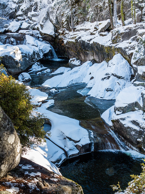
At the few spots where the "trail" got closer to the South Fork it looked like this


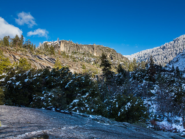
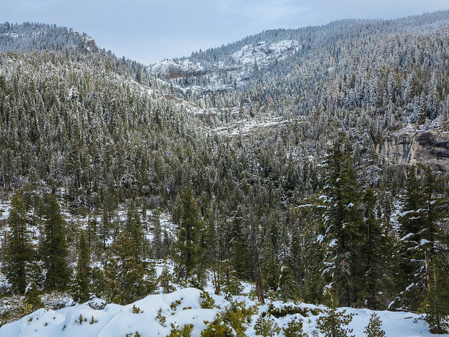
And from the drier areas higher upslope from the river we could see our goal, being the top of the cliffs


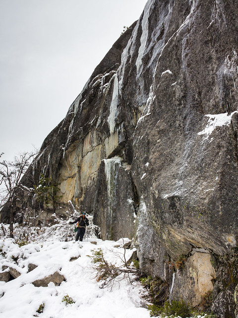
Which we made late in the day, as the clouds were starting to close in. We still had a nice view back down canyon towards Wawona


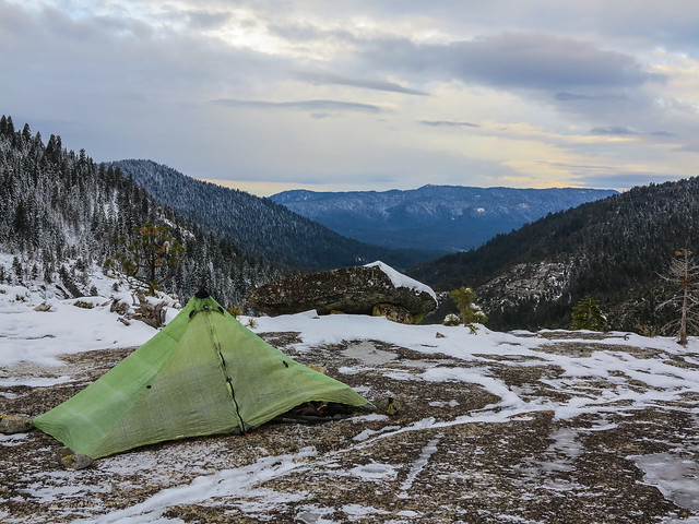
After a windier than expected night, Super Bowl Sunday dawned cold and cloudy. I was feeling beaten up by the hike the day before, the weather wasn't looking great, and the route up Johnson Creek looked more challenging that we (or at least I) could do and still have fun


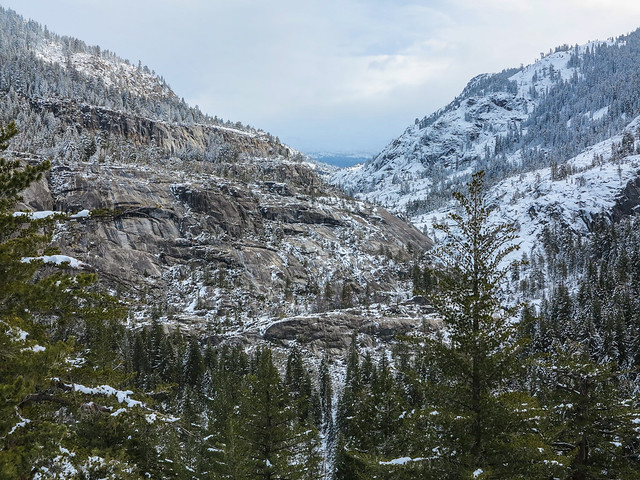
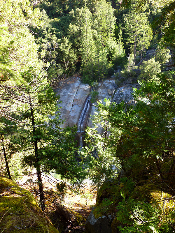
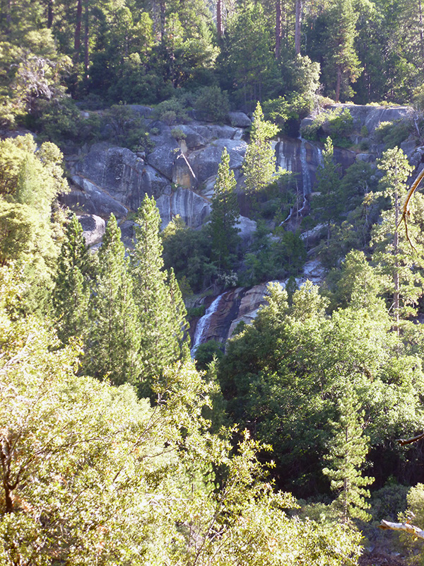
So we decided to save it for another trip. We enjoyed the views further up the South Fork of the Merced:


and then headed back down canyon via a slightly different route, which included this:


this


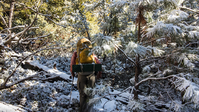
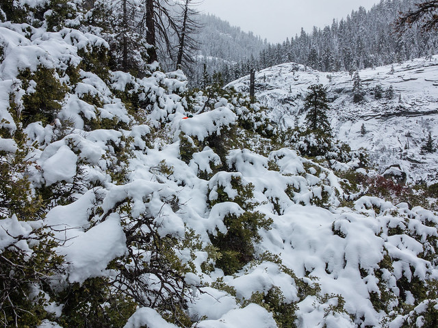
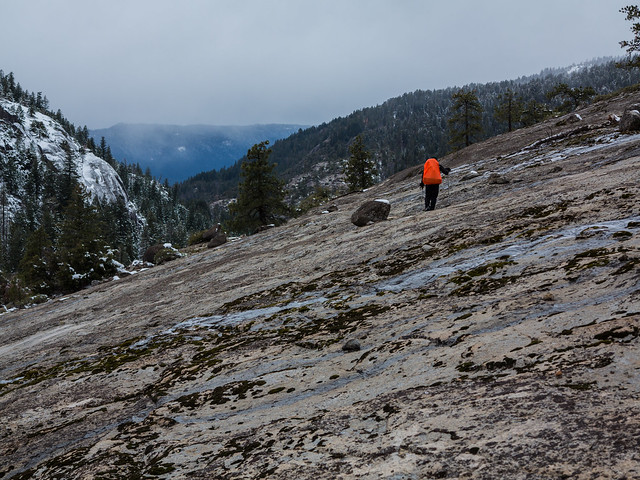
and fighting our way through some of this (look for the orange spec drowning in the sea of manzanita and snow)


which led to more pleasant slabby stuff like this


And we were back in the cars in time to be able to listen to almost all of the Super Bowl on the radio on the way home. Another great weekend trip!

The rest of the pictures are here

The details...well...the "trail" went variously from nice... to overgrown with Mountain Misery.... to easy walking on a carpet of Black Oak Leaves.... to crawling over deadwood.... to crawling under deadwood.... to walking through snow...to where the heck are we going. Closer to the high point of our route we were obviously bushwhacking as, by all reports on the "trail", it ends somewhere before our destination. On day 1 we did not wear and did not need microspikes, didn't wear and probably should have worn gaiters. Day 2 we wore both. The deepest snow we saw was maybe a foot in sheltered areas at 6200 feet. Snowshoes would have been deadweight on this trip and we left them in the car.


Edited 1 time(s). Last edit at 02/03/2014 07:09PM by Bearproof.
Re: Der Snafflebit Trail
February 04, 2014 10:23AM
Woah... that looks awesome. Especially pic #2 of the teacups. Going to LYV this weekend, your pics have me stoked.
avatar Re: Der Snafflebit Trail
February 06, 2014 06:48AM
Quote
AndrewF
Woah... that looks awesome. Especially pic #2 of the teacups. Going to LYV this weekend, your pics have me stoked.

Have fun. Was gonna see if you wanted to go on this one... but there was just too much uncertainty
in the amount of goodness... esp. with plan of head up Johnson Creek... thought the better of it.
Turns out we really should have started Friday like originally planned... o well..
Good luck this weekend. Had thoughts of heading up tmr... but those are now squashed with the
weather and storm coming in. So taking first weekend for the yr. crying


Chick-on is looking at you!
Re: Der Snafflebit Trail
February 06, 2014 10:06AM
Quote
chick-on

Have fun. Was gonna see if you wanted to go on this one... but there was just too much uncertainty
in the amount of goodness... esp. with plan of head up Johnson Creek... thought the better of it.
Turns out we really should have started Friday like originally planned... o well..
Good luck this weekend. Had thoughts of heading up tmr... but those are now squashed with the
weather and storm coming in. So taking first weekend for the yr. crying

Thanks for thinking of me, still want to do a trip together sometime. You are welcome to come get cold and wet with us this weekend. Grinning Devil I'd probably be staying home too if I hadn't already made plans with friends to go.
avatar Re: Der Snafflebit Trail
February 07, 2014 10:15AM
Quote
AndrewF
You are welcome to come get cold and wet with us this weekend. Grinning Devil
Try to stay warm and dry.
Weather thing I'm looking at says:
Winter Storm Warning
Valid from Feb 7, 2014 4PM to Feb 10, 2014 4AM
Looks like it may rain instead of snow though. sad smiley


Chick-on is looking at you!
avatar Re: Der Snafflebit Trail
February 04, 2014 10:49AM
No post-holing? I was a little the weekend before at the top of Yosemite Falls Trail (a little ways past the top). It does look like you gad nice views to wake up to. grinning smiley
avatar Re: Der Snafflebit Trail
February 05, 2014 08:05AM
No. It's all new snow.

Sunset was nicer:


Chick-on is looking at you!
avatar Re: Der Snafflebit Trail
February 05, 2014 10:36AM
Love the sunset. I need to hike where you go!
avatar Re: Der Snafflebit Trail
February 06, 2014 06:45AM
Quote
Hitech
Love the sunset. I need to hike where you go!
Be careful what you wish for...


Feel free to jingle. I'm always looking for new blood.

Please be aware that it's really been fall hiking so far... near record temps for most of the year.
Also one note.. one thing I def. do not do in winter is hike in the dark. When da sun goes
down it can just get ridiculously cold. Also while you are hiking tune into the microclimates
if you can. Just getting up 100 ft. above a valley or from a river can really make a difference
in the temps you experience.

Have fun


Chick-on is looking at you!
avatar Re: Der Snafflebit Trail
February 06, 2014 10:23AM
Quote
chick-on
Feel free to jingle. I'm always looking for new blood.

Please be aware that it's really been fall hiking so far... near record temps for most of the year.
Also one note.. one thing I def. do not do in winter is hike in the dark.

Be careful what you wish for... When I'm in better shape and the conditions are more summer like (I'm not setup for winter, that's why I took advantage of the mild winter) I just might take you up on it. Not sure I could keep up, but loosing the extra weight would certainly help! smileys with beer

And hiking in the dark on an unknown trail did not work out well for me. I did learn a lot though. winking smiley At least it wasn't cold (30 or so).


Edited 1 time(s). Last edit at 02/06/2014 10:25AM by Hitech.
avatar Re: Der Snafflebit Trail
February 04, 2014 04:45PM
Der... Looks Wide Open to me.


Chick-on is looking at you!
avatar Re: Der Snafflebit Trail
February 04, 2014 05:13PM
Quote
chick-on
Der... Looks Wide Open to me.

That's what you always say. Problem is...I still, for some reason, believe you....
avatar Re: Der Snafflebit Trail
February 05, 2014 08:11AM
Re: Der Snafflebit Trail
February 06, 2014 07:49AM
Great report and info, thanks!

Now, I've got a question, please. As you might remember I went up there a couple of years ago, but I took the south shore of the river.
(here: http://yosemitenews.info/forum/read.php?3,41516)
On that trip, there were a couple of moments when I looked across the river, saw some steep features, and thought to myself, "sure glad I'm not trying to go up on THAT side of the river."

So here are photos from the south side, looking at the north side at the terrain that you guys just traversed. And I wondering if you generally went high over the cliffs or low by the river...


avatar Re: Der Snafflebit Trail
February 06, 2014 10:05AM
Quote
Klas

On that trip, there were a couple of moments when I looked across the river, saw some steep features, and thought to myself, "sure glad I'm not trying to go up on THAT side of the river."

Funny, we were looking from the north side to the south side and thinking the same...."sure glad we are not trying to go up on THAT side"....

So I guess the grass is not always greener on the other side.

Chick-on can provide the track. The "trail" portion (i.e. the western half of our route) stays up above the river for the most part, the couple of miles (as the crow flies) from the 6401 knob west we were pretty close to the river.
avatar Re: Der Snafflebit Trail
February 06, 2014 01:39PM
Klas, o yeah. I remember that one well. Actually have been on the north side a few times now...
every time going in a bit more.. Wanted to get to 6402 before telling you what it was like.
There's some nice granite outcroppings to hike around on. Actually went that-a-way to top of
Chilnualna Falls a few weekends ago too.
Looking at your pictures, if I'm right.. the trail type feature goes just below those two falls.
First one looks about at the 27 mile mark... and the second at the 28 mile mark.
I'll send you the tracks and some maps. Do with them what you please.


Chick-on is looking at you!
avatar Re: Der Snafflebit Trail
February 06, 2014 10:00PM
Quote
chick-on
Klas, o yeah. I remember that one well. Actually have been on the north side a few times now...
every time going in a bit more.. Wanted to get to 6402 before telling you what it was like.
There's some nice granite outcroppings to hike around on. Actually went that-a-way to top of
Chilnualna Falls a few weekends ago too.
Looking at your pictures, if I'm right.. the trail type feature goes just below those two falls.
First one looks about at the 27 mile mark... and the second at the 28 mile mark.
I'll send you the tracks and some maps. Do with them what you please.

Even if it is the one from a few weekends ago, be ready for some kick ass Manzanita. It was scrumptious indeed.
avatar Re: Der Snafflebit Trail
February 07, 2014 07:28AM
Mr. Burro... as you know sometimes you just have to do this:

to get to this:


Seriously though... I'm certain Klas will go "dang... dang... dang... " if/when he does the north side ...
I mean... it's..

Wide Open

Of course though... the best stuff is if you can hike more in the riverbed...


** the first 2 photos are not Snaffle-y


Chick-on is looking at you!
avatar Re: Der Snafflebit Trail
February 07, 2014 06:02PM
Quote
chick-on
Mr. Burro... as you know sometimes you just have to do this:

to get to this:


Seriously though... I'm certain Klas will go "dang... dang... dang... " if/when he does the north side ...
I mean... it's..

Wide Open

Of course though... the best stuff is if you can hike more in the riverbed...


** the first 2 photos are not Snaffle-y


Need to preface and add a disclaimer that I am complaining here at all, but I thought I should point out the scrumptiousness. Some may not fully understand how fun it is to tangle with Manzanita, for example, as you go from one point on a map to another. (Or hear the words "wide open" Head roll )

I was just compelled to say this after grimacing at Bearproof's picture of loose snow on the Manzanita above.

Love all the picts, as always! I think Bearproof's are way cooler (and colder).
avatar Re: Der Snafflebit Trail
February 08, 2014 08:54AM
Quote
Catalonian Burro
Quote
chick-on
Mr. Burro... as you know sometimes you just have to do this:

to get to this:


Seriously though... I'm certain Klas will go "dang... dang... dang... " if/when he does the north side ...
I mean... it's..

Wide Open

Of course though... the best stuff is if you can hike more in the riverbed...


** the first 2 photos are not Snaffle-y


Need to preface and add a disclaimer that I am complaining here at all, but I thought I should point out the scrumptiousness. Some may not fully understand how fun it is to tangle with Manzanita, for example, as you go from one point on a map to another. (Or hear the words "wide open" Head roll )
(Or hear the words "It's easyHead roll)
avatar Re: Der Snafflebit Trail
February 08, 2014 09:25AM
That's just hurtful. crying

Wide Open:


And

Easy:
Photosynth of SF Merced from 6402 Granite

Raymond and SF Merced from 6402 Granite

Note to webmasta:
a - this forum does not allow Moderators to Edit post
b - the default view is the crappy chronological view


Chick-on is looking at you!
avatar Re: Der Snafflebit Trail
February 08, 2014 11:20AM
Quote
chick-on


Easy:
Photosynth of SF Merced from 6402 Granite

Raymond and SF Merced from 6402 Granite

Wow, simply gorgeous panoramas!

Thanks for taking the time to create these beautiful photosynths!
.
avatar Re: Der Snafflebit Trail
February 09, 2014 08:04AM
It's nice to know someone looks at these. (I know the webmaster doesn't)

Took a bunch with iPhone over Christmas bp-ing Pohono and Inspiration Ridge...
You can find them here:
http://photosynth.net/userprofilepage.aspx?user=Yosemite_Chick-on

Wholely under/un/not-so impressed with the iPhone ones. Much like the 3D...
with normal camera and post-processing... much much better...
Just really disappointed with iPhone 5c synths... so much so won't do any more with it.
It was kind of nice to talk to parents on Christmas Day though while sitting out
above GP having dinner. smiling smiley And send sibs a picture of the moment.


Chick-on is looking at you!
avatar Re: Der Snafflebit Trail
February 09, 2014 03:11PM
Thanks for the link.

Did you try to do a complete 720º photosynth panorama with the iPhone?

That's where I think the iPhone (or Windows Phone) photosynths (or Android Photo Spheres) excel.

The resolution of a smartphone photosynth simply doesn't come close to what one can achieve by using a real high-resolution digital camera, but the ease of creating (and then verifying it was success while still out in the field) a complete 720º panorama with one's smartphone using the Photosynth app (on an iPhone or WindowsPhone) or the Photo Sphere functionality (found in Android phones with the latest Android OS: versions 4.2 and newer) is the main reason I still enjoy producing 720º panoramas with my iPhone Photosynth app.

For me, there's nothing else like viewing a complete 720º panorama to give me a real visceral feeling of actually being there, witnessing the scene firsthand.

.
avatar Re: Der Snafflebit Trail
February 10, 2014 06:26AM
Once you start zooming in.. it looses it's charm quickly.
360+ from Sentinel Dome from Christmas:
http://photosynth.net/view.aspx?cid=fcd3281e-f0c0-4338-a931-c50e934e53f4

Full screen and zooming in and out. That's what makes the synths for me.


Chick-on is looking at you!
avatar Re: Der Snafflebit Trail
February 10, 2014 10:01AM
Quote
chick-on

Full screen and zooming in and out. That's what makes the synths for me.

Agree 100%.

The incredible detail one can achieve photosynthing a bunch a high-resolution megapixel digital photos into one large seamless photosynth is a sight to behold and marvel at. It's why I enjoy so much viewing the photosynths that you and Basilbop post to this forum.

.
avatar Re: Der Snafflebit Trail
February 17, 2014 07:55AM
Quote
chick-on
Once you start zooming in.. it looses it's charm quickly.
360+ from Sentinel Dome from Christmas:
http://photosynth.net/view.aspx?cid=fcd3281e-f0c0-4338-a931-c50e934e53f4

Full screen and zooming in and out. That's what makes the synths for me.

If one moves the screen all the way up or down you realize chick-on appeared from a black hole. Nice transport system for peak bagging!
Sorry, only registered users may post in this forum.

Click here to login