Welcome! Log In Create A New Profile Recent Posts
A Yosemite bear

The Moon is Waxing Gibbous (61% of Full)


Advanced

Re: Trip Report: One Ticket to Paradise

All posts are those of the individual authors and the owner of this site does not endorse them. Content should be considered opinion and not fact until verified independently.

Trip Report: One Ticket to Paradise
September 11, 2014 05:41PM
They drove me to Yosemite, kicked me out and said "go hike something". So, I did.

Day 1 - http://www.youtube.com/watch?v=G4OTDztS_iA

For this trip, I badly wanted to appear in this photo...


..but that would wait. First up was Half Dome.

I wanted to reach the top before sunrise, so after getting zero sleep in Curry, I hit
the trail at 12:30 am. The inky blackness was broken at the 7000 foot junction by
a pair of green eyes. They did NOT blink. Happily, whatever was behind them
allowed safe passage uphill, and at 6:40, a new day came to Yosemite....


The early hour also brought this ominous sight...


I would then head for Clouds Rest. At the 9000 foot level, the lack of sleep, thin air, and
low energy level brought progress to a grinding halt. At each rest stop, I had to avoid
dozing off. It felt like pulling a plow uphill. Gaining ground like the glacier that built
the place, I eventually found this sight on the east flank...


Given my punch drunk state, I expected to see Janis Joplin and Jimi Hendrix jamming on
top, but the place was deserted. Guzzling water produced no sweat (or anything else), so
I knew that a lower elevation was my friend.

The room was still spinning when I got to the junction, and just before reaching Little Yosemite
Valley, I rolled an ankle on an unseen rock. 4 1/2 miles and a Mist Trail later, I hit the pillow
face first and didn't move for 13 hours. Rough day on the trail.

The next day would produce my new, new favorite place in the park.
Re: Trip Report: One Ticket to Paradise
September 11, 2014 05:46PM
Let's try again: THIS ominous sight....

Re: Trip Report: One Ticket to Paradise
September 12, 2014 03:37PM
Now I have another reason to go back.

DAY 2 - http://www.youtube.com/watch?v=UmTx9y7ePTg

The morning of day 2, the ankle was swollen, but felt
better. After eating and drinking everything that wasn't
nailed down, I took the shuttle bus to the Camp
4 stop, and headed up the granite anaconda known as
Upper Yosemite Falls Trail.

The maple tree leaves do their best, but the sun gets
through anyway, and the morning sun makes things get
sweaty.


It took almost 3 quarts of water to reach the
top, but a check with the Wilderness Office promised
pools of water in the creek, and they were on the
money.


I had the place to myself, and re-fueled from the pools.
The dry rocks were as smooth as Tennessee whiskey, thanks
to centuries of water flow.

Viewed from the Valley, the V-shaped notch at the brink
shows the erosive effects of the water. Here is the other
side of that coin...


Re-hydrated, I headed west toward a long time goal, the
summit of El Cap. After the grinding ascent of the YFT,
the trip to El Cap was a breeze. Before long, I had reached
my goal.


Not sure what purpose this structure serves. A spot for
post-climb, celebratory bone jumping? Mosh pit for a
big wall rave party? Other than a few rock ducks, this
was about all the summit had to offer. I don't know what
I was expecting, but the El Capitan summit was just kinda
....there.

Heading for home, I came to a sign that read EAGLE PEAK .3
miles. Why not?

Simply put, this was one of the best calls of the trip. The
short, entirely uphill hike produced this incredible view...


Of course, watch your step. You don't want to become a
pile of human goulash....


Last year, I made it to Sierra Pt., and it was the "new
favorite spot" in the park. This year, I found this place.
It isn't far from the main trail, the view is breathless,
there are rocks to climb on at the top, there is just
enough clenching to make you pay attention the whole time
....what a place. If my native Nebraska has this spot,
people would name their kids after it. Each year, we'd
hold a 3 day celebration. The view of Half Dome would
replace the block 'N' on the Husker's helmets. Here, it's
just another spot at the end of a squiggly line. And,
it took me 4 trips to the park to get to it. Incredible.

The trip down the YFT is largely uneventful, but the
snake has one last squeeze left in its coils. At about
5200 feet, a couple switchbacks lead....uphill. Uphill
both ways? That's just mean.

The next day, I would face the demon.
Re: Trip Report: One Ticket to Paradise
September 12, 2014 04:41PM
Quote
AnotherDave


Not sure what purpose this structure serves. A spot for
post-climb, celebratory bone jumping? Mosh pit for a
big wall rave party? Other than a few rock ducks, this
was about all the summit had to offer. I don't know what
I was expecting, but the El Capitan summit was just kinda
....there.

I believe it is a windbreak for climbers that top out on El Capitan and then sleep on the summit. Somehow they manage to sleep on the wall fine with whatever they have with them but on the summit they suddenly need a windbreak.

Glad you enjoyed Eagle Peak. It is a wonderful spot that is not well visited.
avatar Re: Trip Report: One Ticket to Paradise
September 12, 2014 08:58PM
I've camped there.
Re: Trip Report: One Ticket to Paradise
September 14, 2014 02:57PM
Q. Why would you want to do the Ledge Trail?
A. Because, I'm a guy, and we do things like that.

DAY 3 - 
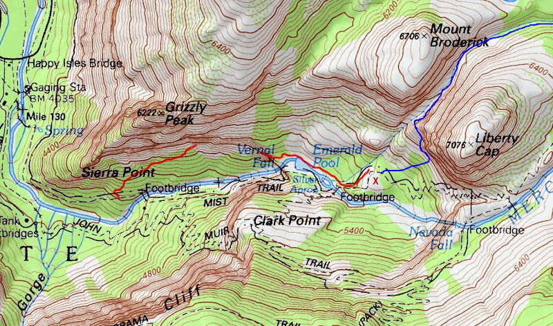
http://www.youtube.com/watch?v=eFYMl_OhiEs

That diagonal green line on the Glacier Pt. cliff
has had me by the ya-ya ever since I found out what
it was, 2 years ago. Abandoned for 60 years ....big
body count...deadliest trail in Yosemite...Last year,
I asked several park employees about it, and they
looked at me like I was wearing a turban. They would
then rattle off a well rehearsed company line about
the dangers of the Ledge, etc. Their warning sunk
in, and I only went up a few hundred feet. This year,
I didn't ask anybody.

On Sept 4, armed with precious little rock climbing/
scrambling experience, I disappeared into the trees
behind the Happy Isles parking lot. Soon, I was on
the Ledge...


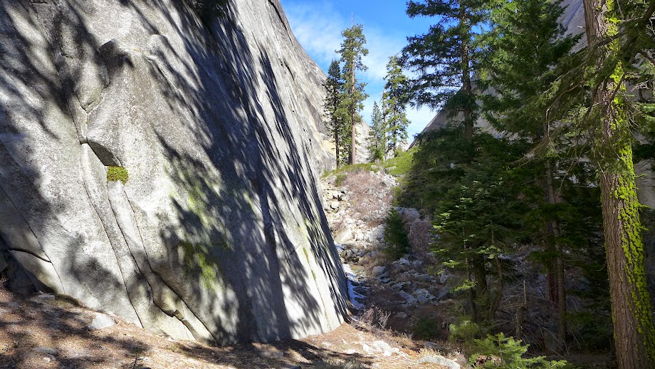
With decades of neglect, the Ledge is littered with
shattered rock from hundreds of feet above. I would
soon discover that big rocks are your friend; they
hold weight better than small ones. Signs of previous
human occupation can also be comforting...


Occasional trees/shrubs can be found. This is a hint
at what lies ahead..


To get an idea of the lay of the Ledge, put your left
hand at belt buckle level. Your left arm now takes the
shape of the trail, sloping upward to the turn at the
elbow, and steeply upward from their. Along the route
is the glorious scenery from the Valley below...


Of course, I had my eyes shut the whole time.

The Ledge Trail offers subtle danger. You won't likely
become a pile of human goulash after a 1000 foot
free fall. Instead, the unstability of the surface could
lead to a slide/tumble of maybe 10 to 100 vertical feet,
with the possibility of a broken bone or separated
shoulder waiting at the bottom. Maybe I was TOO
cautious, but treated every danger spot (read: The
Ledge Trail) as being potentially fatal. Plenty of
paint markings helped with the butterflies...


Of course, these things are only visible when they
weren't needed.

I kept thinking that the 'turn' would signal the end
of the danger. After all, it looked clear and solid from
the Village Store parking lot. The reality is this:
The trail gets steeper in the gulch, and the unstable
rocks are now mostly hidden from view....


Often, obstacles appear in the middle of the gulch. Dead
trees, big boulders or piles of debris make you chose
to go around them, left or right. Since most of the
paint markings in the gulch are toward the right hand
side, I usually went that way.

There are several nasty little 'spur gullies' that you
can accidently crawl into. These will lead up and away from
the main route, and into a dead end. This is where
you can get 'ledged out', or 'rimrocked'. This happened
more than once, and I can't tell you how I got out
of them all.

Here is another landmark along the trail. At this
point, I'm out of the main path...


Maybe this upper gulch section would be better/safer to
navigate at a different time of year, but on this date,
the vegetation had had a whole summer to grow. It was
like going uphill in a jungle, on roller skates.

Eventually, hikers appeared on the 4 Mile Trail above,
and I soon joined them. I almost knelt down and kissed
the path. I had survived.
avatar Re: Trip Report: One Ticket to Paradise
September 14, 2014 04:22PM
Nice report! I am hoping to do that "trail" in a few weeks!
Re: Trip Report: One Ticket to Paradise
September 15, 2014 06:25AM
Good luck Bear. Being gravityproof would help.
avatar Re: Trip Report: One Ticket to Paradise
September 15, 2014 12:00PM
Quote
AnotherDave
Being gravityproof would help.

http://www.ske-art.com/skestuff9/B00JVXT35A
avatar Re: Trip Report: One Ticket to Paradise
September 15, 2014 07:25AM
Re: Trip Report: One Ticket to Paradise
September 15, 2014 09:55AM
Going in the winter would take the vegetation out of
the equation, but it's hard to imagine that adding
snow would help.

I have read (maybe not in this forum) that the Sierra Pt.
Trail is more dangerous than the Ledge Trail. Having done
both, I can offer one opinion: Stack the Sierra Pt. trail on
top of the UYF Trail, on top of the Snow Creek Trail, and
the Ledge Trail will POWER dump upon them all.

Maybe I'm just a wimp, but it took all I had to make it
up that thing.
Re: Trip Report: One Ticket to Paradise
September 15, 2014 03:04PM
To finish off the Ledge Trail story...

When I got to Glacier Point, a classic older gent in a Yosemite
uniform was gathering some tourists for an impromptu Q & A
session. He showed some photos of the area from long ago
(including some of a hotel that once stood there), and gave
a talk about the firefall. With snow white hair and beard, he
had been going to the park for around 70 years and had been
a volunteer there for 40 or so. I waited till the crowd dispersed
to begin picking his brain.

"Do you know anything about that old Ledge Trail that used
to be around here somewhere", I asked.

(Keep in mind that in contrast to the pristine condition of the
rest of the Glacier Point crowd, I was showing the effects of
my recent trip up the Ledge. My arms and legs were scratched,
and my clothes and pack were littered with leaves and debris.
I resembled a half eaten bigfoot.)

Instead of calling cops at the mere mention of the Ledge Trail,
which is standard procedure for park employees, he offered
some sage wisdom. He said that a couple park rangers that he
knew had done the trail 10 or 12 years ago. They told him that
it took all their skill to get to the top, and that they would
NEVER attempt the trail from top to bottom. "Of course, almost
nobody does that trail anymore" he added.

I said nothing.
avatar Re: Trip Report: One Ticket to Paradise
September 15, 2014 10:08PM
Quote
AnotherDave
I said nothing.
I think that was the right thing to say
Re: Trip Report: One Ticket to Paradise
September 16, 2014 04:09PM
Day 4 produced a hike to Sentinel Dome and Taft
Point. This is fairly mediocre stuff for this
forum, so lets skip it.

DAY 5 - http://www.youtube.com/watch?v=NfbBw-YMBeQ

Before leaving Curry, I PROMISED myself not to
get into any trouble. Any blocks in the road, and
I would turn around and live to hike another day.
Armed with this plan, I headed toward what would
be a triumphant trip to the Diving Board. Thanks
entirely to this forum, I had learned that this
goal could be reached via several routes, and I
would go uphill between Mt. Broderick and Liberty
Cap.

Shortly after leaving, the plot thickened. I noticed
a fine looking lass, hiking alone, heading towards
Happy Isles, like myself. She stopped to take a photo,
and I went by. Somewhere below Sierra Pt., I stopped
for a drink, and she caught up. Turns out that she
was from Germany, and didn't mind some company.


As sweet as streudel, she was fine company, and I
asked about her trip to the US. Here favorite things
about our country are 1) National Parks 2) Good
hamburgers 3) German beer.

She was doing the Mist/JMT loop, and I considered
punting my planned hike, just to tag along with
the lovely frauline. But, after crossing the bridge
between the falls, I took one last look and bid her
adieu. Sometimes, you just gotta let 'em go.

The route between the two peaks was clogged with
debris...


This final blockage was the end of the line. I could
get little traction on the rounded rock towards the
right, and threw in the towel. I would NOT get in
trouble, as promised.

It only took a few minutes to backtrack to the Mist
Trail, and I headed uphill with my carefully planned
day tossed in the dumpster. In a matter of minutes,
I not only threw away a chance to hike with a fine
German lass, but wimped out on a trip to the Diving
Board. An epic double fail.

Half way up Nevada Fall, a new plan was struck. I
had all day to do something, and this object was
close at hand...


Why not?

Between Half Dome and Liberty Cap, a route to the top
comes to view. This ditch or gulch or whatever it is
called would be the route to the top...


It wasn't overly tough, and even I couldn't get too
lost. Once on top, I looked all over for a survey
marker and found none. I tried to find a vantage point
that would provide a photo of the fall below, but
didn't REALLY get that close to the edge. After all,
the folks down by the fall didn't want anyone
dropping in unexpectedly.

I did snap this shot of what MUST include a preferred
route to both the Diving Board and the Snake Dike...


So far, nothing about this trip had gone as planned.
But, with only a half-day hike remaining, Sept. 7
would surely be better.
avatar Re: Trip Report: One Ticket to Paradise
September 17, 2014 06:55AM
Nice efforts wit da Board... but if ewe wanna go b/t Liberty and Brod...
you probably want to go all the way nearly to the base of Liberty...
right after the trail zips out of the woods and makes a right turn..and
then all those steps appear... hang a left there... and you'll find the
climbers trail. try dat next time. surprised you didn't go Lost Lake
route once by Lib route up Lib cap... by den you maybe tinking about
the Pizza n German Beer that got away... tongue sticking out smiley
Have fun (is Indian Canyon next ? ) tongue sticking out smiley


Chick-on is looking at you!
Re: Trip Report: One Ticket to Paradise
September 17, 2014 08:40AM
Admittedly, I butchered the Diving Board hike. But, that's just
one more reason to go back.

As for Indian Canyon - The older gent I talked to at Glacier Point
spoke a little about it. It looks almost vertical and would be a
real challenge.

These off-trail hikes are the fun ones, if you make it out safely.
The Ledge was tougher than I thought it would be, but it
can be had. Maybe Indian Canyon can as well.
avatar Re: Trip Report: One Ticket to Paradise
September 17, 2014 09:03AM
No biggie. It's all good fun. They can
all be done even with a full pack.
How the Chick-on travels
Have fun n Be Safe


Chick-on is looking at you!
Re: Trip Report: One Ticket to Paradise
September 17, 2014 09:13PM
Quote
AnotherDave
This final blockage was the end of the line. I could
get little traction on the rounded rock towards the
right, and threw in the towel. I would NOT get in
trouble, as promised.

It only took a few minutes to backtrack to the Mist
Trail, and I headed uphill with my carefully planned
day tossed in the dumpster. In a matter of minutes,
I not only threw away a chance to hike with a fine
German lass, but wimped out on a trip to the Diving
Board. An epic double fail.

A thousand apologies. I thought that I had posted a description of this route in my listing of abandoned trails in Yosemite Valley:
http://yosemitenews.info/forum/read.php?3,67811

Well, the route was mentioned, but I remember now that I had put off giving a proper description because I had never checked out the route sketched on the old map overlay, i.e., the one running straight up the gully from the bottom. I guess that you have done that for me, and it's not very nice.

Years ago, I found the proper route on my first try, coming from above, and had never spent the time to check out various alternatives near the bottom during the many times that I have done it since then.

Here is part of the old overlay. Keep in mind that the overlay was just drawn in as a guideline, and is not a survey. See thread:

http://yosemitenews.info/forum/read.php?3,72638,73312#msg-73312


A quote from that thread:

As you climb up from the valley today, you cross the bridge at the Silver Apron, then follow the Upper Mist Trail around to the right until you reach an open flat place at the foot of Liberty Cap where the hotel stood to your right. To your left is a grove of trees, through which a foot path passed between Liberty Cap and Mt. Broderick to Little Yosemite Valley (the current trail from there up to Nevada Falls had not yet been built).

I have followed that route a number of times (though always entering from the base of Liberty Cap, not straight up the gully from the hotel), but have never seen any stonework. I think that it was just rough footpath, not a stock trail. More of a scramble than a trail.


Also in that thread, which is about the old Anderson Trail, is this map, to which I have added in blue the correct route. The red lines are Chick-on's rendering of the existing segments of the Anderson Trail. X is the site of the old hotel:


This another one of those Yosemite routes where a marvelous ledge appears just as you are wondering where to go next. Basically, you proceed directly to the base of the great face of Liberty Cap. As you hit the wall, you are in an area often containing rock climbers' camps. Follow to the left directly along the base of the wall, climbing fairly steeply until you come to a marvelous wide horizontal ledge that takes you around the corner and into the gully. Be aware that there will be a bushy step down at the very end. Short people may want a boost up when coming the other way, unless they elect to perform an undignified grappling act with that bush.

Beyond that point is a most wonderful little valley. Snow avalanches clean out the brush most winters. I've never seen it very being very bad. At the very end there is some easy scrambling or route-finding to get up to the outlet of Lost Lake. This is real off-trail stuff, though, so expect some steep loose stuff and talus. But it's mostly easy, if you keep your eyes open....

Somewhere there are some photos, but I can't find them right now. Perhaps Chick-on has some. Here is an old stereograph that he posted looking back down the old route:


Edited 3 time(s). Last edit at 09/18/2014 12:01PM by wherever.
avatar Re: Trip Report: One Ticket to Paradise
September 18, 2014 07:35AM
Re: Trip Report: One Ticket to Paradise
September 17, 2014 06:39AM
There are at last count four routes to the Diving Board but once at the bottom of the ridge you either take the climber's route (exposure and class 3-4) or the hiking route (steep climbing up through the trees with a little hand and foot work).

I have gone the Lost Lake route from LYV, and the Emerald Pool route straight up along the gully to the left of Broderick.

Liberty Cap is fun - you sit above all the tourists below, feeling like a bird...
Re: Trip Report: One Ticket to Paradise
September 18, 2014 06:28PM
On this day, I would go to another favorite spot, but would also
wave good-bye to this incredible place.

DAY 6 - (sniff) http://www.youtube.com/watch?v=sOK4U_pSxGA

The fastest week of the year would end today. My ride would be
here by noon, so hiking options were limited. Fortunately, Yosemite
has a gem of a hike that can be done in just a few hours: Sierra Point.

When the big rock slide buried the bottom of this trail, Yosemite
considered its options, and took this trail off the map. Today, even
with some towering boulders keeping their secret, it is fairly easy
to find the old path. Just climb to the top of the big boulder field and
ask yourself "where would I build a trail"?

Angle upward and to the right, and a faint trail will emerge. Like any
steep section of another trail, there will be switchbacks to deal with,
and about half way up, stone steps will show themselves....


Everything about this hike is fun. There's nobody here, you're NOT
supposed to even know about the place, and the steepness of the
slope adds just enough danger to keep things interesting. And, all the
trees (plus a little thing called Half Dome) keep the burning sun at bay.

It doesn't end there. If we're handing out an award for the coolest 30
feet of hiking trail in the park, the Nebraska judge votes for this stretch...


Of course, there's always that one thing that makes this spot unique to
any other on Earth, but you know what that is.


About the only thing wrong with the whole place is that unsightly water
tank down yonder. Maybe Mother Nature will take care of that for us
someday.

We all have our favorite place or places in Yosemite. On this trip, I added
Eagle Peak to that list. But, Sierra Point.....some of the things listed above
and others that I can't define make this trail and destination combine for
a hike that I looked forward to during the whole trip.

Thanks, Yosemite.

P.S. - I figured out how they got that pipe railing assembled. Give a yell if
you want me to spoil the secret.
Re: Trip Report: One Ticket to Paradise
September 19, 2014 09:15PM
Anything flowing from V, I, or N? Y looks completely dry.
Re: Trip Report: One Ticket to Paradise
September 20, 2014 04:41AM
Yosemite Falls was dry, but the others had minimal water flow.
Sorry, only registered users may post in this forum.

Click here to login