Welcome! Log In Create A New Profile Recent Posts
Bridalveil Falls, Yosemite National Park

The Moon is Waxing Gibbous (71% of Full)


Advanced

Re: Old Coulterville and Old BOF roads

All posts are those of the individual authors and the owner of this site does not endorse them. Content should be considered opinion and not fact until verified independently.

Old Coulterville and Old BOF roads
August 13, 2015 01:04PM
I've hiked the entire lengths of the Old Coulterville and Old BOF roads (at least as far as the park boundary), with 2 exceptions:
  1. OCR between Little Nellie Falls and Mercer Grove
  2. OBOFR between Tuolumne Grove and the intersection with the old Tioga Road (which I believe is near the current Carlon Day Use area)

Since both of these stretches are a little far to do as out-and-backs in a day (at least for me), my wife has generously offered to drop me at one end and pick me up at the other (while she goes horseback riding) but I'm not sure how long an estimate I should give her as to when to meet at the other end. I suspect that these two stretches are reasonably clear but I'm not certain. So, a few questions for anybody who's done these stretches fairly recently:
  1. I know I need to add time for my usually dallying, exploring, picture taking, etc. but should I allow extra time for bushwhacking or should I expect pretty clear sailing?
  2. Am I correct that the OBOFR comes out at Carlon Day Use (I know there's an old road there and it has the feel of the OBOFR but, without doing a good map overlay, I'm not sure if it's the OBOFR or the OTR)? On some maps, it looks like the old road comes back to the current BOFR at Hodgdon Meadow but, based on the old maps I've looked at, it appears that it continued past that to intersect the OTR somewhere along the current Evergreen Rd.
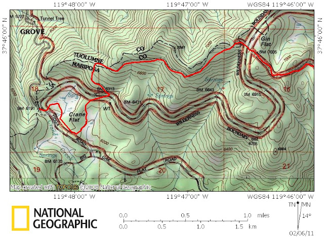
  3. This one's really for chick-on: I found the GPS track below in your photos and was curious about the track between where the "Gin Flat loop" (the part of the OBOFR that goes north of the current Tioga Rd for a short stretch). I've hiked that loop but couldn't find what happened to the OBOFR when it got back down to TR (near the BM6313 on the map). Your track looks like you daled about between there and where the OBOFR leaves the Tuolumne Grove parking area (the loop that wraps part way around the words "Crane Flat" on the map below). Did you actually find the old road there or were you just hunting for it?


Edited 1 time(s). Last edit at 08/13/2015 01:06PM by DavidK42.
Re: Old Coulterville and Old BOF roads
August 13, 2015 06:48PM
Quote
DavidK42
2. Am I correct that the OBOFR comes out at Carlon Day Use (I know there's an old road there and it has the feel of the OBOFR but, without doing a good map overlay, I'm not sure if it's the OBOFR or the OTR)? On some maps, it looks like the old road comes back to the current BOFR at Hodgdon Meadow but, based on the old maps I've looked at, it appears that it continued past that to intersect the OTR somewhere along the current Evergreen Rd.

Was doing some more digging and found the answer to this question in this thread from a few years ago. Anybody know if Rob65 is still hanging around this board? I've been finding some really interesting posts of his from a few years ago.
Re: Old Coulterville and Old BOF roads
August 14, 2015 11:32AM
I'm here, David. Thanks for the PM.

I have not hiked the section of the Old Coulterville Road from Merced Grove to Little Nellie Falls, but I think it is pretty clear and open. Once you go past Merced Grove, it receives less use but I think it's a pretty obvious path. I think the Stanislaus National Forest has closed the portions of the OCR (and connecting FRs) outside the YNP boundary to auto travel in the wake of the Rim Fire and current drought conditions, but you might check if you are planning on using a car to access the Little Nellie Falls area.

As for the OBOF Road, remember that there are really TWO "Old" BOF roads in this area -- the original pack trail that was converted into the stagecoach road and the later automobile road that eventually became (Old) State Highway 120. The one you are referring to is the latter. To lay it out as I understand it (and others can correct me if I am mistaken):

1) The original BOF pack trail and stage road is mostly coincident with Old Highway 120 (Hardin Flat Road) from Crocker's Meadow (the site of Crocker's Station, now outside the YNP boundary) to the west. However, east of Crocker's Meadow, the original BOF road veers off to the right just to the east of the Rush Creek bridge and took a fairly direct path east over the ridge (Crocker Ridge) to Hodgson Meadow, crossing the modern Highway 120 right at the current park entrance station and then going through the campground and Park employee residential area to rejoin the later BOF Road.

2) The automobile version of the Old BOF Road (old Highway 120) continued east from the Rush Creek bridge along what is now Hardin Flat Road, but did not turn north to meet modern Highway 120 as Hardin Flat Road does. Instead, the Old BOF Road/old 120 briefly follows the road that becomes a Forest Service road heading south to Five Corners and then used to continue straight where that road makes a sharp turn to the right -- this section was drivable up to a couple years ago, but construction of the Rush Creek Lodge has blocked it off. It went over the ridge and descended, crossing the modern 120 right at the Evergreen Road intersection (you can easily see where the old road came down from the ridge). The old road is mostly buried by Evergreen Road (which follows its path except for two places, one just east of the modern 120/ER intersection and another just west of the Carlon Day Use area where the old alignment descended directly into the day use area on the north side of modern ER; the current access road from the Day Use area to the ER crossing is the old alignment), although it was all reconstructed and widened in the 1960s when the new 120 and BOF park entrance was opened. Old BOF/120 crosses modern ER and parallels the river to the meadow area where it curves to the right -- this is the former site of Carl Inn and was the old YNP boundary and entrance station location. The road is closed to vehicles from here on but is paved and is a nice easy walk from here up to Hodgson Meadow, where you rejoin the original stage BOF Road. The two are basically the same from there up to Crane Flat through Tuolumne Grove.

3) The Old Tioga Road (or Great Sierra Mine Wagon Road) originally began at the Old BOF Stage Road east of Crocker's Meadow/Rush Creek and basically followed the OBOF Road/old 120 alignment from there to just before Carl Inn, where it split off and crossed the river on a bridge that no longer exists and then curved north, paralleling modern ER road before eventually merging into its path. Modern ER overlays the OTR from this point to where the OTR splits off toward Aspen Valley a mile or so farther on.

As I mentioned to you, I was just at the site of Crocker's Station a few weeks ago and found it very interesting.
Re: Old Coulterville and Old BOF roads
August 17, 2015 01:02PM
Thanks for the info, Rob (and good to see you posting again!). As far as driving on the OCR, NEVER!!! spinning smiley sticking its tongue out I can't find it right now but I know somebody posted about driving the old road from Coulterville to Big Meadow a few years back but, for me, part of the joy in these old stage roads is imagining what it was like to actually ride it on a stage or on horseback. Much easier to do that on foot than in a car!

I think I'm probably going to do this stretch of OCR and save the remaining OBOFR segments for a later trip (that lines up better with my wife's plans to drop me at the Mercer Grove TH, drive to the Valley, do a bit of horseback riding and then meet me in Big Meadow).

Thanks for the tips on finding the OBOFR outside the park boundary...I haven't tried to trace it there yet so this gives me a little more incentive to go looking for these "missing" segments!

TR when I get back...
Re: Old Coulterville and Old BOF roads
August 17, 2015 09:04PM
Have a good trip! I'm jealous.

Finding the original Old BOF Road segment from Rush Creek/Crocker's to Hodgdon Meadow might be a bit hard, at least on the western end because there are so many other dirt roads meandering about in that area and, since this OBOF road section was never paved for autos (unlike the segment from Carlon Day Use Area up to HM), there's really nothing to distinguish it from the other Forest Service roads. Once the road enters the park, it becomes easy to trace as it traveled in more or less a straight line (perpendicular to the modern BOF Road) right through the HM campground and along a fence line (some trees are planted along it, probably dating from the original HM settlement days) over to where it rejoins the later OBOF Road. There is another abandoned portion that forms a half-circle around the northern edge of Crocker's Meadow on the west side of Rush Creek; I walked along this section when I was there a few weeks ago.
avatar Re: Old Coulterville and Old BOF roads
August 17, 2015 01:39PM
OBOFR and OCR are in v good shape. Can walk them without much issue at all.
From Twin Bridges OCR is still drivable...
From Merced Grove cabin to Twin Bridges is more trail now... but in great shape...
keep a look out from a boundary marker as you walk out of the park.

have fun!!!

(sorry not posting so much... been out and about hiking a weee bit this year)


Chick-on is looking at you!
avatar Re: Old Coulterville and Old BOF roads
August 19, 2015 07:03AM
Thru Crane Flat I was poking around looking for the old road... but I didn't find anything...
Other than the ski trail...

The ski trail up towards Crane Flat Lookout... that is old road... which continues south
over BOF and continues...

Anytime I wander around in that area I invariably find an old road/railbed and "have" to
see where it goes... good fun ... in my book

Have fun!


Chick-on is looking at you!
Sorry, only registered users may post in this forum.

Click here to login