All posts are those of the individual authors and the owner of this site does not endorse them. Content should be considered opinion and not fact until verified independently.

Trip Report - Cancel my flight home
September 14, 2015 07:09PM
With six full days of hiking on the schedule, this would be the best trip ever.
It would begin with a triumphant romp up a forbidden trail I had only read
about on this forum. That was the plan.

https://www.youtube.com/watch?v=WJDnJ0vXUgw

I scoured the Valley Loop Trail for the trailhead for my first attempt at Indian Canyon.
I wasn't expecting a flashing neon arrow to point the way, but surely something
inviting would appear. Nothing. Eventually, I lost patience, and headed up hill.
Hear is some of what I found:


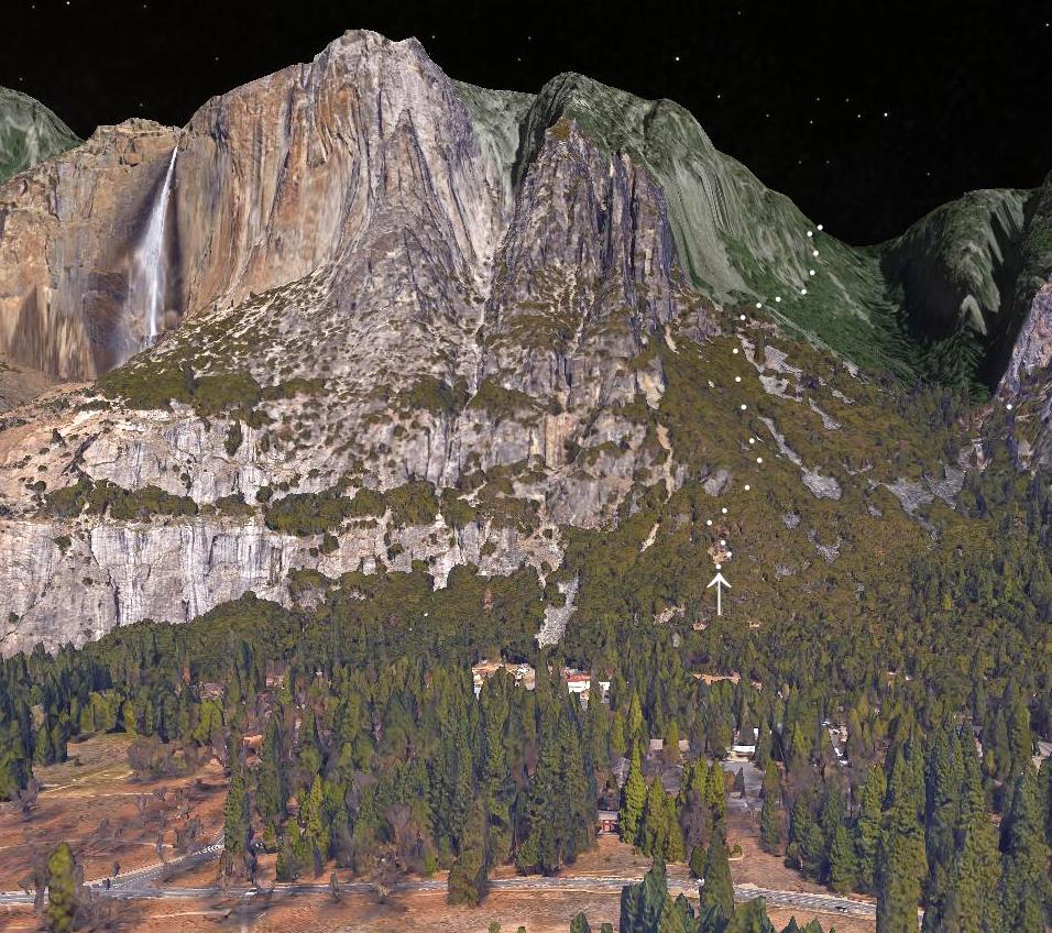
Pretty stuff. I began to suspect that I had never been on the "trail". The entire
route was either an oak forest or one of many granite avalanche chutes. The
only real landmark was a huge pine tree...


I went to the left, or the uphill side of this tree. That lead to nowhere. After
1800 vertical feet, I got "that feeling". Not wanting to become a missing hiker
on the first day of the trip, I threw in the towel and headed down. Eventually,
the Valley Loop re-appeared, and I headed west.

Beaten, I headed for Columbia Rock. Somewhere beyond it, there is supposed
to be an "off ramp" that would lead to a view of the entire Yosemite Falls, guarded
by a railing. My route finding skills are non-existent, but I did find the trail, and
this view...


This sight prevented the day from being a total loss, but as I headed for home,
I kept hearing a version of a Matt Hooper line from JAWS..."This is not a
hiking trail!"

I have learned one thing from this forum: When the heavy weights hit the trail,
their hikes have a couple common threads:
1) Back country
2) Lake or lakes

In the morning, I would see for myself.
avatar Re: Trip Report - Cancel my flight home
September 15, 2015 07:15AM
Sounds like you half a dome been taking my hike-on class.
smiling smiley

(Just blast uphill baby!) (C-O M-O)

(and you found the right tree... you prolly went too far west and uphill at that pt)
(been there... done that... )

Have fun (and be safe)


Chick-on is looking at you!
Re: Trip Report - Cancel my flight home
September 15, 2015 10:32AM
Am I correct to assume that the pool, visible near the center of the photo, is at the top of the lower fall?
Re: Trip Report - Cancel my flight home
September 15, 2015 10:58AM
The pool is not at the edge of the lower fall. It is upstream from that.
Re: Trip Report - Cancel my flight home
September 15, 2015 03:00PM
The water is cold in that pool.

Re: Trip Report - Cancel my flight home
September 16, 2015 07:10PM
Thanks for the first installment of your trip report.

Quote
AnotherDave
I scoured the Valley Loop Trail for the trailhead for my first attempt at Indian Canyon.
I wasn't expecting a flashing neon arrow to point the way, but surely something
inviting would appear. Nothing. Eventually, I lost patience, and headed up hill.

I'm sorry that you missed the start of the Indian Canyon (IC) Trail. The turnoff from the valley tourist trail is at approximately 37.75216, -119.58749. I say approximately, because reflections off the canyon walls move the apparent coordinates around randomly. It's close to local high point in the tourist trail. The rangers usually knock down any ducks put at the junction, and since the tourist trail has been moved a few times, the original trail intersection is well below the current tourist trail. Luckily, the old trail is now a use trail that the climbers use for the first half dozen switchbacks or so. Once you get on it, it starts off as a pretty good trail. Higher up the mountain it disappears in a number of places.

As I said before, it's a lot easier in the downhill direction. See:

http://yosemitenews.info/forum/read.php?3,49133,49133#msg-49133

https://picasaweb.google.com/103089501068510688008/Indian#5526451739286007346

http://yosemitenews.info/forum/read.php?3,67811,67811#msg-67811


A view that might help you locate the trail is shown on this Sunnyside Bench thread:

http://yosemitenews.info/forum/read.php?3,64970

The track shown there was taken on the way down from Sunnyside Bench, but the X in the woods to the right (east) of it is where we left the Indian Canyon Trail on the way up to Sunnyside Bench. At that point, the IC trail makes a turn to the right, away from Sunnyside Bench.

Here is a Google Earth view of the Indian Canyon Trail.


The dots are just my simplified version of the route. Here is a close-up of the start.


In this picture, the mess in the foreground is the park service maintenance area in Yosemite Village. The rangers' horse pen is just out of the picture on the left. Number 1 is at the tourist trail, where it passes along the bottom of the talus pile leading to Sunnyside bench. Numbers 2 and 3 also point out the tourist trail, which comes to a local high point between 1 and 2. The IC Trail starts up near that high point, and just below a clearing. Because of vegetation and a steep bank, you can't quite see the clearing from the tourist trail The IC trail switches back past a nice lookout near the top of the clearing, then plunges into the woods. There are plenty of switchbacks, but the ones that I have drawn are just schematic. Better luck next time.


Edited 1 time(s). Last edit at 09/16/2015 07:13PM by wherever.
Re: Trip Report - Cancel my flight home
September 16, 2015 06:53PM
On Aug. 31, at 4am, I hit the trail, bound for my first Yosemite lake. Heavy weight country.
This one would be fun.

https://www.youtube.com/watch?v=jqxNSvFMkag

Merced Lake had always been nothing but a blue blotch at the end of a squiggly line
on a map. Once beyond LYV, the whole hike would be new. Much of the route would
go through the majestic forest, where the mighty human can feel mighty small..


It didn't take long to find evidence that even the towering pines can be brought to their knees...


Last year, the Meadow Fire roared through this area. I watched from the safety of Glacier
Point as the angry smoke rolled over the top of Half Dome. In places, tree tops were green
with flickering signs of life. In others, nothing escaped. A year later, even the most
charred land showed signs of life...


The forest is eternal, and it will be back.

The Merced River made a delightful companion, with several cascades providing audible
and visual splendor...


The prior day's debacle seemed far away.

From Nevada Fall, the next 10 miles or so would only rise around 1200 feet. It took an hour
to hike through the burned area, and several foot bridges gave easy access to both sides
of the river...


Eventually, the goal was reached...


As I gazed at this sight....


...a thought did occur: "The heavies are right. These lakes are pretty cool".

The next day, I would attempt to avenge a year old defeat.
Re: Trip Report - Cancel my flight home
September 17, 2015 06:49PM
Last year I failed to find a route between Liberty Cap and Mt. Broderick and
didn't make it to the Diving Board. This year, a new route would bring new
results.

https://www.youtube.com/watch?v=1lWJXDG2i0A

Here's the problem: I read trip reports that experienced hikers put on this forum, and
automatically think that I need to go there. That started the fascination with Diving Board.
Wouldn't it be cool.....Well, on Sept. 1, I passed this familiar landmark...


...and headed for LYV. (I recognized some of the water that was going over Vernal
Fall; I saw it yesterday at Merced Lake) After finding the turnoff, I wound through
the trees toward my second Yosemite "lake"....


Thinking that I belonged on the other side of Lost Lake and that I was probably
on the wrong trail, I plugged along anyway. I didn't want to end up at the Snake
Dike, but a steady stream of ducks eventually lead away from the big granite thing.


The ducks were so numerous, they almost touched each other. The trail wound
through a steeply forested route. (Bring your long pants for this one. Bring your
hands too) After some time, this sight emerged...


I thought of this boulder with the duck squatted on top as the "victory duck".
It would surely be easy to find on the way down.

It was surprising how much sand was at the top. What wasn't a surprise was all the
gravity...


(Those socks were white when the day started)

I took an "Ansel Adams" picture, but it didn't compare. This is wide, wide angle lens country.

This turned out to be a worthwhile hike. I got to see a couple guys doing the Snake
Dike route, and another brave lad standing on the edge of the visor. Other than that,
the trail from LYV was all mine.

Tomorrow would be Half Dome day.


Edited 1 time(s). Last edit at 09/17/2015 06:54PM by AnotherDave.
Re: Trip Report - Cancel my flight home
September 18, 2015 09:59AM
Thanks for the update. Happy Half Dome. There neat things to do up there, even if you don't get to the cables. Such as Quarter Domes, or the climbers trail down to where you can look at the face of Half dome....
Re: Trip Report - Cancel my flight home
September 18, 2015 06:56PM
Sept. 2 - So many hiking options are available, but which to choose? Pohono?
Mt. Starr King? Indian Rock? Ledge Trail? Ah, but with a certain piece of paper
in the back pack, the choice was already made....

https://www.youtube.com/watch?v=RPgKwByiRIE

This would be my fifth time to get a grip on the cables...


..and about the only thing new about the top of Half Dome was a birds-eye view of the
Meadow Fire burn:


But, before heading for home...


..I offer my Top Ten list of all things Yosemite:

1) A powerful force has taken over the Park. More powerful than the draught, the
plague or even hauntivirus, it is, of course, yoga pants.

2) The only way a mule hauled Ansel Adams camera gear to the Diving Board is
if Adams carried the mule.

3) I found this spot..


...early in the trip. Now, I'm wondering who was the first guy to fall off of it?

4) I overheard 3 park employees talking about some of the things they get
asked. They included (a) Which one is Half Dome? (b) Where is the glass
elevator that goes to the top of Half Dome? (c) How much concrete did it
take to pour Half Dome? (d) Why did you turn off the waterfalls? (e) When
do you release the bears? None of the 3 had answers to these questions,
so I must have stumped them all.

5) A new dining option is the Saturday night BBQ at the Curry Pavilion. The
brisket wasn't bad.

6) A guy named Conway built the Yosemite Falls Trail. At about 5200 feet
on that trail is a thing called Columbia Rock. What Columbia did they name
this after and what does Conway have to do to get something named
after him?

7) In my 5 trips to Half Dome, a park employee has been on duty to
check the permit twice.

8) I always thought that a Yosemite crew was in charge of trail upkeep,
but I met a hearty group from the California Conservation Corp who
said that it was their baby.

9) I met so many pairs of yoga pants, I put them into 3 categories:
(a) Bad idea
(b) Good idea
(c) GRAPHIC idea

10) A guy once told me that on a clear day, you could stand atop Half Dome
and see the ocean. Wrong. After all these times on top, I am positive that you
CANNOT see he ocean from up there - The Empire State Building gets in the
way.

They'll never get me with that one again.
Re: Trip Report - Cancel my flight home
September 18, 2015 07:16PM
Quote
AnotherDave
...At about 5200 feet on that trail is a thing called Columbia Rock. What Columbia did they name
this after...?

Why, Columbia, gem of the ocean, of course.

https://en.wikipedia.org/wiki/Columbia,_the_Gem_of_the_Ocean

Quote
AnotherDave
...what does Conway have to do to get something named after him?

Try googling "conway park", and you will see that there are way, way too many Conways for him to stand out. He should have picked a funny name.

Thanks again for a great trip report. I wish I were there, and I don't even own any yoga pants. Maybe chick-on should get some.
Re: Trip Report - Cancel my flight home
September 21, 2015 06:35PM
Every trip to Yosemite, I find a new "favorite place". This year,
it was the entire hike to Merced Lake. A year ago, I found a
spot on the map with a view that would give Glacier Pt. a run
for its money. I had to go back to that place this year, just
for another look.

https://www.youtube.com/watch?v=kU8OJAOMbPg

Eagle Peak, baby. Would it be as impressive the second time
around? To find out, you first ascend this zig-zaggy creation...


...to the top of the biggest waterfall in North America. While there, I would
investigate the overlook, where only water was missing. I would also venture
on to Yosemite Pt., before entering a shaded and cool stretch of forest that
would lead through Eagle Peak Meadow. These locals...


were the only companions to pose for a picture, although I did see
half a bear. (the south half)

The spur trail to the destination is only .3 miles, according to the sign, but if
it is less than twice that distance, I'll eat my back pack. It is the longest .3 miles
I've ever hiked. Worth every inch though. It yields this view...


And, I was there.

When I re-live various trips to Yosemite (an almost daily occurrence), I try to
come up with my favorite view. It usually turns into a top ten list, and Eagle
Peak is always on it. The next day would produce another such sight.
avatar Re: Trip Report - Cancel my flight home
September 22, 2015 06:39AM
Quote
wherever
I wish I were there, and I don't even own any yoga pants. Maybe chick-on should get some.

I prefer Spanx. They keeps me chick-on gut in checks.

(If eye go the Yogurt way... I either go tighty whities on outsides... or boxies... depending on how the guys wanna hang)
tongue sticking out smiley

Half a Dome fun out der
Eye Yam!
Chick-on is looking at you!


Chick-on is looking at you!
Re: Trip Report - Cancel my flight home
September 17, 2015 10:15PM
When in doubt, throwing in the towel is probably the right thing to do. Paraphrasing Ed Viesturs:

"Summiting is optional, returning safely is mandatory." And while this is probably taking things too far for most adventures, using the "Everest 2PM" rule as a guideline isn't a bad idea either.

Those YF pools look quite inviting, especially when there's basically no flow. It's scary how low the water is. Even Bridalveil is completely dry. And thanks for sharing the DB photo. I gotta get up there sometime.
Re: Trip Report - Cancel my flight home
September 23, 2015 05:34PM
I never want to leave Yosemite, but the incentive to hit the road
can take many forms....


...so, with one full day left, I headed in a familiar direction.
https://www.youtube.com/watch?v=uHZJej98_T0

I've been to the top of Clouds Rest from either direction, but prefer the eastern
approach...


From the Valley, this route is longer and will now require hiking through more
burned out forest land, but the final ascent is more dramatic. The 5000ish foot
slope into Tenaya Canyon was as daunting as ever....


The summit was breezy and very cool on this day, but hikers that I met were
bundled against the weather. They were from Guam, Texas, New Orleans, Japan
and Oakland, and wore long pants, hoodies, stocking hats and gloves. I wore a
T-shirt. I'm from Nebraska.

As always, the view from the top was among the best in the Park.


A year ago, I attempted to reach this spot on the first day. A lesson learned.
After roaming the Park at lesser elevations for a few days, there was no hint
of altitude sickness that hit me last year.

Of course, there is only one proper reward for such a demanding hike...


The next morning, I would go to Sierra Pt. (the left rear post is broken off
at ground level), and then bid farewell to this incredible place. 6+ days,
110 miles and over 26,000 vertical feet of hiking, and it didn't seem
like nearly enough.

And, it wasn't.
avatar Re: Trip Report - Cancel my flight home
September 23, 2015 06:32PM
Quote
AnutterDave
... and it didn't seem like nearly enough.

Eye Understand

Glad u had fun n
Tanks fir Sharon!!
Chick-on is looking at you!


Chick-on is looking at you!
Re: Trip Report - Cancel my flight home
October 11, 2015 10:14AM
@ AnotherDave ... re: Socks ... yep ... I fixed that problem with these.

https://dirtygirlgaiters.com/product/black-out/


:-)
Sorry, only registered users may post in this forum.

Click here to login