Welcome! Log In Create A New Profile Recent Posts
Tenaya Lake, Yosemite National Park

The Moon is Waxing Gibbous (61% of Full)


Advanced

Re: Kibbie Lake 5/3/16

All posts are those of the individual authors and the owner of this site does not endorse them. Content should be considered opinion and not fact until verified independently.

Kibbie Lake 5/3/16
May 10, 2016 02:45PM
Finally made it out to Kibbie Last week after trying for almost a month. For one reason or another everybody that was suppose to go with me bailed so I ended up heading out to Kibbie Myself. So heres a little Picture report of the trip.


Left Fairly early on Tuesday morning and made it out to Cherry a little before 9

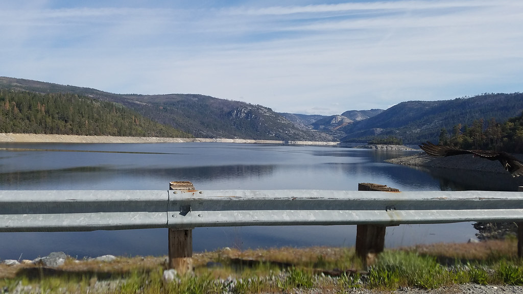
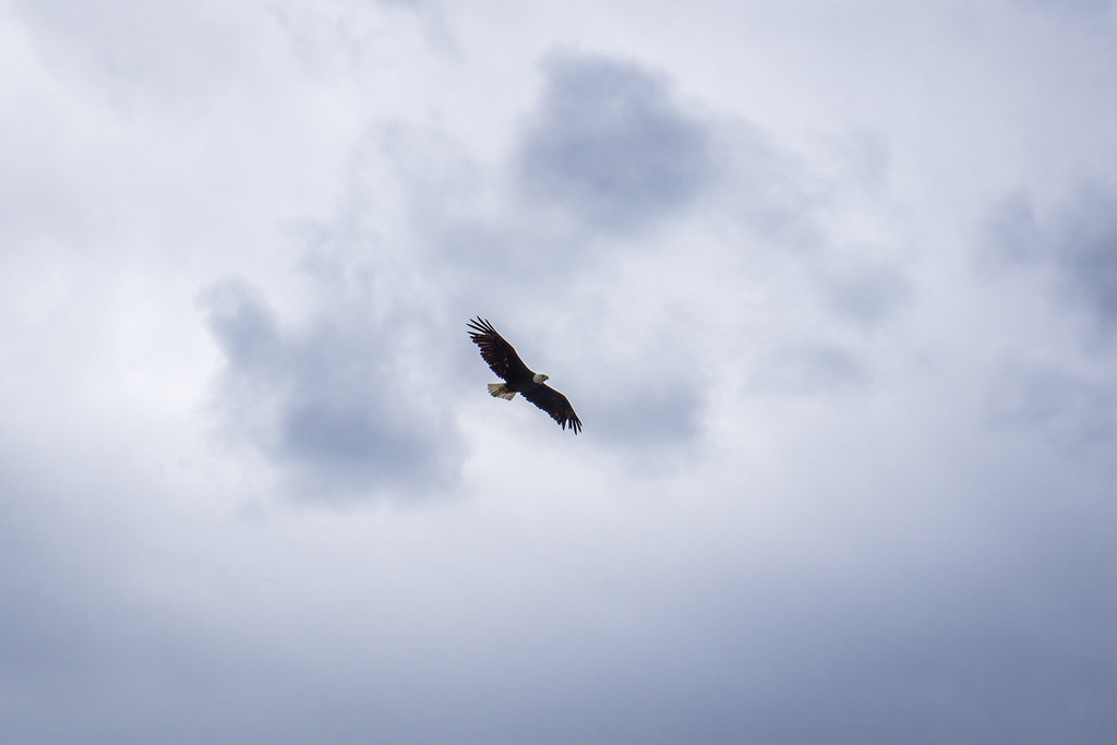
yes that is a vulture bottom right


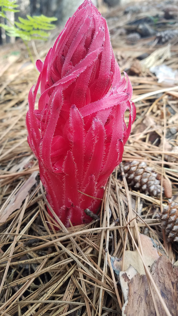
Lots of snow plants on the way out.


Lots of burned area to walk through the entire way out there. All in all the trail was in fairly good condition though it was a little brushy in a few areas.


Set the camera up while I grabbed some lunch a few miles from lake
(Click image for time lapse video)


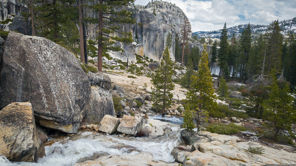
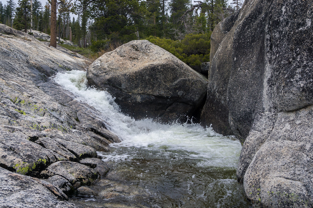
Instead of crossing over the creek I decided to climb up on the left side and follow the Granite down to the lake


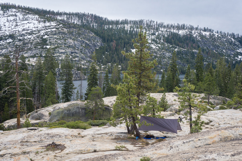
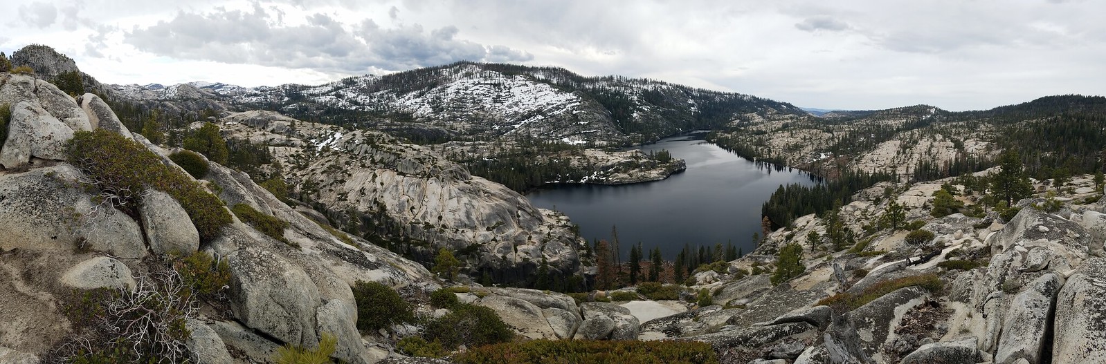
Made it to Kibbie a little after 1 and began searching around for where to camp at


I ended up heading all the way to the north side of the lake before I found anything like I liked. Ended up camping next to the sachse spring fed creek up a few hundred yards from the lake on some granite


Not to shabby of a campsite. Though it did take far long to find a place I liked then I thought it would


Was nice listening to the rather loud Cascades at night


Was pretty cloudy and overcast most of the time I was out there so the sunset wasn't anything spectacular but I did take a little time lapse of it anyway
(Again click image for the video)


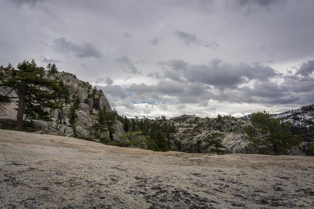
The next morning after packing up camp I took a little hike up to the top of the ridge of the north side of the lake


Finally got a decent picture of the Bald Eagle that had been around the area while I was out there


Took a bit of time lapse of the clouds while up there and then grabbed my pack and started back out to the car.


Heres the time lapse I took, click the image to get see the video.


Nothing else of interest happened on the way back to the car so thats where my trip report ends. I do have a question or 2 for those of you who frequent the area. I know kibbie is a very popular backpacking destination so much so that the've had to initiate a quota and ban fires but other then it being fairly close I didn't really see the appeal. Don't get me wrong the lake is very pretty and I absolutely love the area around it and I didn't even run in to anyone while out there but it just seems to me that its far to brushy and overgrown to really be enjoyable. Getting around the West side of the lake to that river took me a couple of hours because I had to cross what must have been a few hundred fallen logs from the various fires in the area. On the way out to the lake there were a number of logs across the trail as well as some points where brush had overgrown badly enough that you could see people were very obviously having to leave the trail and push through brush and downed trees just to move forward. All I explored of kibbie was the west and north west sides of the lake so I can speak for the other sides but from what I did explore just getting down to the water was a task. Small manzanita, downed logs, dead ferns, and plenty of other debris from fires and such made a pretty good wall around most of the shoreline I checked out. Because I hammock camp and was solo I was able to setup basically where I wanted to but I am curious about where you guys go when your tenting with any sized group?

From my explorations it seems to me that Kibbie needs a good deal of upkeep done to it. Now I understand the whole Leave No Trace thing and completely agree with it but a certain amount of upkeep does need to be done to the area to make in enjoyable for people especially after storms, drought and multiple fires have gone through the area. Anyway, all the brush, hard travel, and limited campsites kinda caught me by surprise because I know how popular a destination that lake is. Kibbie has already been filling up the quota each weekend since it opened a few weeks ago so I know people have been out there pretty regular.


Edited 1 time(s). Last edit at 05/11/2016 02:10PM by randomsteve95370.
avatar Re: Kibbie Lake 5/3/16
May 10, 2016 05:35PM
Nice pictures and report, thanks.

Out of curiosity, did you park at Cherry and walk in, or was the road open to either the Eleanor trailhead or Shingle Springs?

I've enjoyed camping there twice, but on both occasions it was early season and I had the place to myself. Snow camp during the first drought year, and April of last year.
Re: Kibbie Lake 5/3/16
May 10, 2016 08:16PM
Have been to Kibbie several times over decades. A sister lake to similar Spotted Fawn with tall cliffs right into the lake. Favorite early season destination because at 6.7k it is one of only a few large deep lakes in the Central and Southern Sierra usually snow free by end of May. Traditionally most people camped at the south end near the outlet either along the beach east of the outlet or in the grove of trees beside the large bowling pin bay. Those and the north end of the lake are also the most mosquito prone in early season.

http://mapper.acme.com/?ll=38.05061,-119.84683&z=16&t=H

The other place people camp at is west of the west shore back up in the glacial flats. Am guessing you stayed close to the lake edge that is rather brushy as can be seen in the above satellite image. Travel along the west shore is unpleasant as there are several glacial granite joint cracks to navigate across each full of brush. There are tons of open gruss flats to camp on well above the west shore though shade may be limited. However far less mosquitoes during sunny hours. I have backpacked all around the lake though 99% of visitors cannot get past the two main impediments. You saw those at the north end. Continuing east to get from there down to the inlet stream area at the northeast end continues to be an unpleasant bushwhack. Early season that stream is full of spawning rainbows much like Falls Creek into Vernon Lake. And that is also why bald eagles frequent the lake.

But the most difficult section is the southeast shore where a long length of dense ceanothus, willow, aspen, and white firs on a steep slope with bedrock boulders create a difficult barrier only a monkey might enjoy. If one perseveres, eventually will reach a granite bluff with high vertical rocks that in early season has little waterfalls that plunge directly into the lake. On the satellite image here:

http://mapper.acme.com/?ll=38.05061,-119.84683&z=16&t=H

Good spots to camp there that in our era were pristine. Glaciers scoured the bedrock such that the west side of the lake is shallow while the east side is very deep. Thus the water directly below the bluffs is too deep to see the bottom. One can jump off the bluffs at various heights into the water with some spots way higher than I'd ever want to. Beyond there travel further north continues to be a bit brushy and aspen grove swampy of modest difficulty. The really high cliffs into the lake are along the large peninsula at the northeast end of the lake. Check out this youtube video:

https://www.youtube.com/watch?v=yKjPeaAlVek


http://www.davidsenesac.com


Edited 1 time(s). Last edit at 05/10/2016 08:20PM by DavidSenesac.
avatar Re: Kibbie Lake 5/3/16
May 11, 2016 07:08AM
I was told to let it go, not say anything.

But I can't.

Really sorry you hated the area.


Chick-on is looking at you!


Edited 1 time(s). Last edit at 05/11/2016 09:20AM by chick-on.
Re: Kibbie Lake 5/3/16
May 11, 2016 11:31AM
Not every corner of Yosemite is interesting to everyone, but... every corner is interesting to some people (and birds).

And if you are having a hard time getting around Kibbie, you're doing it wrong:
Re: Kibbie Lake 5/3/16
May 11, 2016 11:52AM
See my other post below for more detail but I definitely agree that I was doing it wrong! One day I will save up and get a pack raft and then no corner of Kibbie will be safe from me and my hammock!
Re: Kibbie Lake 5/3/16
May 11, 2016 12:24PM
During my first trip to Kibbie, I thought I would hate it because I want on the trail that lies to the right of Kibbie Creek. Lo and behold, that was the area that burnt out....plus it didnt even seem like the trail was maintained lol. We even ran into a ranger that seemed lost. I guess after seeing burnt trees all day Kibbie was a sigh of relief! If you go back out there, I'd join you as I'd like to pack raft to some of the small islands. Also would like to explore the western side of the lake. Was so tired bushwhacking that I stopped maybe 500 feet from the lake shore lol.

-Kevin


Edited 1 time(s). Last edit at 05/11/2016 01:08PM by KevinD.
Re: Kibbie Lake 5/3/16
May 11, 2016 08:13AM
Great photos. What kind and what size is the tarp you were using?
thanks,
Re: Kibbie Lake 5/3/16
May 11, 2016 11:50AM
Quote
ttilley
Nice pictures and report, thanks.

Out of curiosity, did you park at Cherry and walk in, or was the road open to either the Eleanor trailhead or Shingle Springs?

I've enjoyed camping there twice, but on both occasions it was early season and I had the place to myself. Snow camp during the first drought year, and April of last year.


The road is open all the way to the top of the Shingle springs TH. I ended up parking about halfway up at the Lake Eleanor crossover point and started my hike from there which added another 1.5ish miles to the hike. Only reason why I did was because I was in my little passenger car out there by myself and when I last checked out the top of the road last year it wasn't in great condition and the ranger I talked to said it was about the same if not a little worse. So I decided to just do the extra mileage and not even worry about checking the road condition up higher.


Quote
DavidSenesac

The other place people camp at is west of the west shore back up in the glacial flats. Am guessing you stayed close to the lake edge that is rather brushy as can be seen in the above satellite image. Travel along the west shore is unpleasant as there are several glacial granite joint cracks to navigate across each full of brush. There are tons of open gruss flats to camp on well above the west shore though shade may be limited. However far less mosquitoes during sunny hours. I have backpacked all around the lake though 99% of visitors cannot get past the two main impediments. You saw those at the north end. Continuing east to get from there down to the inlet stream area at the northeast end continues to be an unpleasant bushwhack. Early season that stream is full of spawning rainbows much like Falls Creek into Vernon Lake. And that is also why bald eagles frequent the lake.

But the most difficult section is the southeast shore where a long length of dense ceanothus, willow, aspen, and white firs on a steep slope with bedrock boulders create a difficult barrier only a monkey might enjoy. If one perseveres, eventually will reach a granite bluff with high vertical rocks that in early season has little waterfalls that plunge directly into the lake. On the satellite image here:

http://mapper.acme.com/?ll=38.05061,-119.84683&z=16&t=H

I kinda wandered back and forth. At first I expected to be able to follow the shore line and find a place to camp within a few hundred feet of the water in one of the little forested parts but I soon realized that was not going to happen and was going to be a ton of work just to walk through that area so I ended up heading up the granite a bit to get out of all the brush and to look for camps up there. All the brush and thick forest was a bit of a surprise to me being that so many people are out there each year I would have assumed it was easier travel, but I think the biggest shock was all the dead and downed trees that just seemed to kinda be all over the place. Not only is hopping logs not the most enjoyable thing ever but its also a pretty large fire hazard. Things were already starting to look kinda dry while I was out there and that's scary. One good lightning strike in a couple of months when things are really dry and the whole place could burn again which I definitely don't want to see happen.


Quote
chick-on
I was told to let it go, not say anything.

But I can't.

Really sorry you hated the area.


I definitely did not hate it. In fact I'm sure you can agree with me that its pretty much impossible to hate any area you backpack out to. Fact of the matter is that I was able to grab my pack, hike up some very interesting terrain, find some awesome views and then spend the night in my favorite hammock. As far as I'm concerned its impossible to hate an area that allows you to do those things. Kibbie lake was not what I expected that's for sure, nor was it exactly what I hoped for either but that doesn't mean its a place I hated. I was hoping to find a hike and lake that would be suitable to take first time or inexperienced hikers out to but I don't see Kibbie being an enjoyable experience for them. Anyway, bush whacking, log hoping, and campsite searching aside I had a great time out a kibbie. The temperatures were perfect, the waterfall I found was beautiful, the ridge I climbed up to had amazing views, and I even had fried spam and scrambled eggs for breakfast. Not a bad way to spend a couple of days. The only bad part about the whole thing is that instead of curing the itch to get out for awhile its made it 10 times worse. tongue sticking out smiley


Quote
pakoR
Great photos. What kind and what size is the tarp you were using?
thanks,

Its actually a tarp I made myself. Its roughly 10x12 and with cordage and all its weighs just under 16oz its made of a material called Silpoly. Its just like Silnylon that is so popular but using a polyester thread instead of nylon. Heres a few other pictures of just the tarp.


All in all I think Kibbie just kinda surprised me. I was expecting a place that gets so many people per year that they've had to introduce quotas and fire bans so I figured I would find a place full of trails, used campsites and zero wood from all the campfires from times past. And just in general I expected lots of places where people camp regularly and lots of signs of use. When I got out there and found that absolutely none of that was true I was really quite shocked. My first thought was if so many people are actually coming out here where in the world do they all camp? My next thought was that I must have missed something very important and there must be some section of the lake that everyone goes to and I just happened to pick the side that everyone avoids or something. Thus the question of where you guys camp when out there. I guess in the end its just a brushy hard to navigate lake and people kinda camp all over the place which is cool but also very interesting to me. All that aside it was a fun 2 days and while its not going to be a place that I got to several times a year like some other places I really enjoy it is a place I want to go back to and explore further not only around the lake more but also beyond the lake and out into that section of the Emigrant/Yosemite divide of the upper cherry valley.
avatar Re: Kibbie Lake 5/3/16
May 12, 2016 06:53AM
Sounds like Leave No Trace is working.

You would hate backpacking with me... I have no problem spending an hour looking
for THE place to camp. Though Kibbie has a zillion places.... literally I can think
of 8 different places have camped there....

If wife is with... it's more difficult due to Hammock... but still...


The area has been burned many times... Kibbie Ridge fire... Rim Fire...
if it burns again... I wouldn't be too concerned... it's wilderness.

Lots of lakes with cliffs... Spotted, Flora, Boundary... all with same type of terrain...
work the shrub I say... but then again... I am a monkey


Chick-on is looking at you!
Re: Kibbie Lake 5/3/16
May 13, 2016 08:43AM
I think that you're on to something about distance to TH being a factor in several ways. Last year wife and I did a 5 day loop around the area (finally completing a route first attempted in 2012 but failed - needed chick-on guidance to figure it out). Kibbie is pretty, no doubt. It was later in the season, mid-week, and we saw no one - except a ranger that insisted on seeing paperwork. Chatted for a while. Found some old markers in an area that I would bet was once a prime camping area (too close to the lake by "modern" standards) on south shore. I think she may have been concerned that we were going to disobey the "No Camping" sign, since it was late in the day by the time we arrived. Seems there has been a big effort to restore the area and they are serious about wanting it to stay that way. The proximity to TH makes that more difficult and requires diligence (IMO - can't say that's a fact). We picked up a few bits of previous visitors' detritus we spotted and walked out to Shingle Springs TH.

If you do get back to the area (beyond the CC drainage itself) you might enjoy the other lakes to the NE of Kibbie. We found them all to be spectacular (but we have a special fondness for the whole CC area). Boundary, Little Bear, Spotted Faun, Flora (and other unnamed) are paradise (for us). Didn't see a soul the entire time there. We walked from Flora over the ridge and through a devastating burn (Rim Fire) to get to Kibbie.

It's a beautiful area. Enjoy.
avatar Re: Kibbie Lake 5/3/16
May 13, 2016 05:11PM
Thanks for the report, good stuff!

And if Kibbie is not to your liking...maybe try Loch Tablae?
avatar Re: Kibbie Lake 5/3/16
May 13, 2016 06:42PM
Quote
Bearproof
Thanks for the report, good stuff!

And if Kibbie is not to your liking...maybe try Loch Tablae?

What's this? Retribution for dissing Kibbie?


Old Dude
Re: Kibbie Lake 5/3/16
May 14, 2016 02:12PM
Lol you guys are all to much. I'm glad everyone enjoyed the pictures and am sorry if I stepped on any toes by saying Kibbie wasn't exactly what I expected.


Edited 1 time(s). Last edit at 05/15/2016 09:13PM by randomsteve95370.
avatar Re: Kibbie Lake 5/3/16
May 17, 2016 07:05AM
A number were just surprised because there's a whole lotta granite and lots of places
to throw your tent up. It was especially interesting your comments because you
did this already:
http://yosemitenews.info/forum/read.php?17,78025,78025#msg-78025

(JKW and I hiked from Eleanor inlet last weekend... and it's a bit shrubalishious...
also hiked up to the Froggy Waterfall...
Seas were at least 40 ft. ... the boat turned into a 3 hr tour... Luckily the Chick-on wasn't lost)

tongue sticking out smiley

Have fun out there (if am in Emigrant and I sees ur doggie I'll see if its you)


Chick-on is looking at you!
Sorry, only registered users may post in this forum.

Click here to login