Welcome! Log In Create A New Profile Recent Posts
Dogwood bloom in Yosemite Valley

The Moon is Waxing Gibbous (61% of Full)


Advanced

Re: TR: Red Peak Pass loop

All posts are those of the individual authors and the owner of this site does not endorse them. Content should be considered opinion and not fact until verified independently.

avatar TR: Red Peak Pass loop
July 27, 2016 06:04AM
Hey guys and gals, here's a TR from my recent YNP trip 7/13-18. I did the Red Peak Pass loop and was joined for part of it by Basilbop, JKW and Chick-On. My trip was supposed to be a lot longer, had planned to include looping in and out of the Vogelsang area, but once again altitude affected me so I cut my trip short. Still had a great trip, here are some highlights...

I really tried this time to acclimate to the altitude -- instead of jumping from sea level up to the trail I arrived to the park a day early to do a dayhike to get my blood pumping a little and then sleep in the Valley at 4,000. Ended up still not working very well, next time I'm looking into Diamox.

So I came to the park with Old Dood, set up in the backpacker's campground and then dayhiked partway up the Yosemite Falls Trail. From Columbia Rock:


From Oh My Gosh Point, middle and lower Yosemite Falls:


Next day I got picked up by Basilbop, JKW and Chick-On, and we headed up to the Mono Meadow trailead. Crossing Illilouette Creek:


From the creek we actually headed up towards the Panorama trail and then back to Illilouette, two long sides of a triangle rather than the single short segment, so that some in our party could check off some Trail Quest segments. First night's camp was a nice ridge just west of the Clark range:


Even though only about 7,300 ft and having slept at 4,000 the night before, I started feeling a bit of altitude at camp, not too bad though. Next morning, the sun rose from just behind Mt. Clark:


As we continued hiking up towards Ottoway Lakes I started to feel the altitude more, didn’t/couldn’t eat lunch, and later in the afternoon pulled off the trail. When the other three had gone through a round of “I thought he was with you”, Chick-On backtracked to me. We ended up camping near the Merced Pass lakes, nice views west to Starr King, HD, CR, etc:


And views back towards Red Peak:


Beautiful sunset:


The next morning we set out for Red Peak Pass:


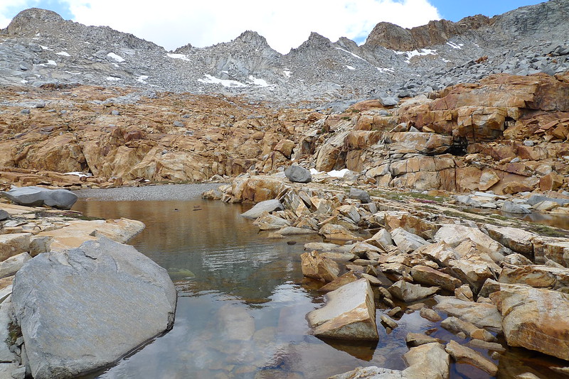
The flotilla launched at Lower Ottoway Lake, while I hiked around:


The climb up from Lower Ottoway really isn’t bad, I had read about it being tough but it is nicely graded and supplemented with normal-sized steps in places:


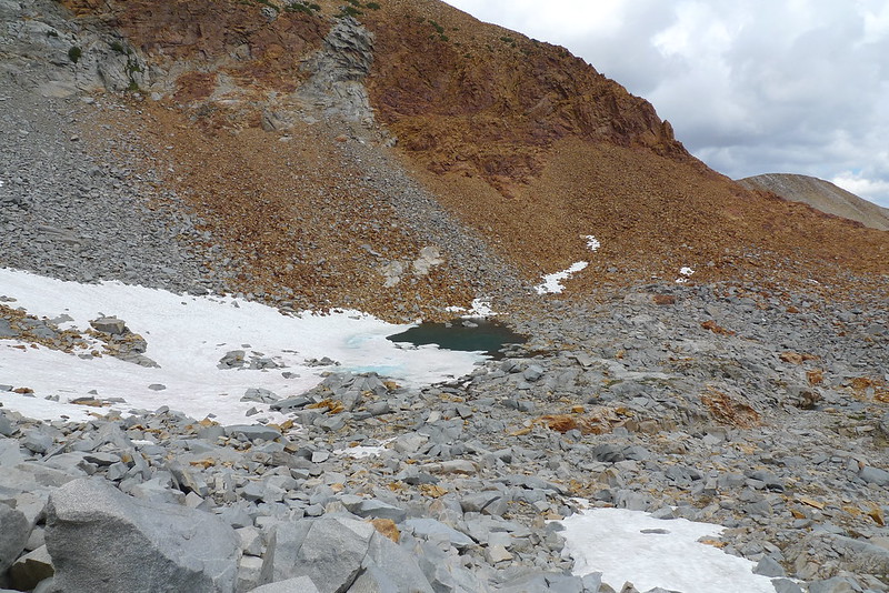
The flotilla then took to Upper Ottoway Lake (in the background)…


…while I rested under the very last tree before the final push up to the pass. I still wasn’t feeling great but more importantly still wasn’t eating. Nonetheless, I was determined to bag Red Peak Pass:


JKW was very sweet, she kept feeding me energy chews and Cheetos, timing my water sips, and I do think it helped. The challenge with AMS is everyone tells you to keep drinking and eating, and yet AMS makes you feel like those are the last things you want to do. JKW kept me on track – thanks!

Almost to the pass. The trail is nicely cut into to approach – from here it looks like it will be a steep hand-over-foot scramble, but it’s actually a moderately graded, smooth trail. Do you see chick-on ahead of us?


At the top of Red Peak Pass:


The view back to the south where we had come from is amazing:


And yet it paled (IMO) to the new views around to the north and east, looking all up and down the Cathedral Range, the entire upper Merced River basin, and even the Ritter Range looked close enough to reach out and touch:


The trail down from the north side of the pass still had a decent amount of snow to traverse:


We don’t need no steenkin’ crampons!


Looking back up to the pass:


Descending to Red Devil Lake where we camped for the night:


Once at RDL the flotilla launched once again:


The next morning I parted ways with Basilbop, JKW and Chick-On, they headed back over Red Peak Pass to loop back to the car while I continued down to the Triple Peak Fork.


Crossing the Merced Peak Fork:


I still, still wasn’t eating, and I knew this wasn’t sustainable. There were times my stomach felt very hungry, but the dehydrated food I brought was just very unappetizing to me – I literally (literally!) was choosing to starve rather than eat it. I could feel the padding on my body had shrunk down to nothing, I probably had dropped about 10 pounds over the past 4 days. Whatever the reason, I knew I had to get back to civilization and get some food in me before I could even consider continuing on my extended trip. I decided to make it to Merced Lake HSC that day to see if they had a walk-up dinner available.

Reached the Triple Peak Fork and a blessedly level trail for several miles:


This area of the canyon is spectacular, where the Merced Peak Fork and Lyell Fork merge in quick succession, becoming the Merced River proper:


Eventually reached Washburn Lake:


From there it was just a few short forested miles to the HSC. And yes they had a walk-up dinner available! I chowed down on soup, salad, roast turkey, cornbread, veggies, and dessert. And about 10 cups of the electrolyte lemonade they serve. I literally (yes, literally) could feel my body putting the padding back on within a couple of hours. Slept at the HSC and ponied up for a cooked breakfast the next morning – pancakes, eggs, potatoes and fruit for me, though they also had oatmeal and sausage.


At this point I thought about regaining my original itinerary and going up to the Vogelsang area, but I felt that trying to go back to my dehydrated food would end up in me not eating again, so I decided to just head down to the Valley. Down past Merced Lake, fish were jumpin’ that morning:


The river again funneled into a canyon, and the trail criss-crossed the river as it descended through Echo Valley towards Bunnell:


Finally reached the burned-out areas of Lost Valley and the upper part of Little Yosemite Valley:


Soaked my feet at the top of Nevada Fall, watched idiots swimming just above the head of the fall, then descended the Mist Trail to the Valley:


Once in the Valley I called Old Dood to explain why I was done earlier than expected. We decided I should try to call the flotilla because they were supposed to be coming off the trail that evening as well, perhaps I could catch them coming down Glacier Point Rd and could get a ride out of the park with them. I left them a voicemail message and sure enough I got a call back a little while later as they were just getting into cell range but before leaving the park, and there were able to pick me up. Got back to Old Dood’s that night. Hung out at Old Dood’s the next day, changed my flight back to ATL for the day after that, and then headed home.

Maybe I could have continued to Vogelsang – sitting here now feeling better I’m telling myself that of course I should have. Maybe I would have found my dehydrated meals appetizing (as I have on past trips). But it probably was the smart choice to bail, and I still had done a classic hike around the Red Peak Pass loop, plus Vogelsang makes a nice itinerary unto itself for a future trip. So all in all a great time. Hope you enjoyed reading about it.

I’ll leave you with some of the beautiful flowers I found along the trail:


Edited 2 time(s). Last edit at 07/27/2016 06:15AM by JRinGeorgia.
Re: TR: Red Peak Pass loop
July 27, 2016 07:30AM
Looks like a gorgeous trip, in spite of your altitude woes sad smiley Glad you made it through generally unscathed. All the pictures are lovely (I'd love to do a hike through this region at some point) but I was especially intrigued by your shot lining up Starr King, HD & CR...I don't think I've ever seen them arrayed in quite this manner before...quite fascinating to me...all the more so because they make HD & CR look so far apart...almost all the views I've seen are from angles that make them appear right next to each other.

I'm curious, since (like my wife and me), you are an east-coaster, do you fly out to California with all your camping gear or do you just bring the most "personal" stuff and rent (or borrow) the remainder when you get out there? Until we manage to relocate to the west coast, we've always stuck to day-hikes but, as we all know, there are so many parts of Yosemite that you just can't get to and from in a day!
Re: TR: Red Peak Pass loop
July 27, 2016 08:33AM
Thank you for posting your trip report and all the lovely pics! Great to have some pics of all of us on the lake together! And the three jumping fish in one shot? Wow!!!

I was simultaneously impressed and very concerned as you kept persevering on the trail! And you had a great attitude through it all! When I have felt ill from altitude in the past, I was not nearly so pleasant to be around!

So glad you were able to walk the Merced River down to the Valley. It's a classic in my book and I never ever have tired of that gorgeous canyon.

And now on your next trip, you can play and explore more around Vogelsang! Lots of good stuff around there!

It was a pleasure hiking with you and I look forward to seeing you again on your next adventure out here!


Edited 1 time(s). Last edit at 07/27/2016 08:34AM by JustKeepWalking.
Re: TR: Red Peak Pass loop
July 27, 2016 09:32AM
Words can't describe the beauty of those photos. Incredible.

I did the Curry/Merced Lake/Curry day hike last year. Your shots of that area
brought back great memories.

As always, I'm humbled by the majesty of Yosemite.
avatar Re: TR: Red Peak Pass loop
July 27, 2016 10:38AM
That was a fantastic trip report! Stunning photos and I felt like I was along for the trip. I think I'll wait a few days and go back through it again. Thanks for taking the time to post it.
Re: TR: Red Peak Pass loop
July 27, 2016 11:14AM
Great trip report! Thanks for the share! Glad you were still able to enjoy it even though you had altitude issues. In regards to the dehydrated meals, could you just not stomach them due to the altitude or do you just not like them in general?
avatar Re: TR: Red Peak Pass loop
July 27, 2016 02:07PM
Thanks all for the comments, compliments, and questions...

Yes, HD and CR usually are seen from angles in which they appear closer, or at least compressed into a line-up. I've cross that saddle between them and it is a good couple of miles, in fact I checked my route log and from the summit of CR, following the trail down until the long switchback that you can continue straight off of to the Quarter Domes, then x-country across the saddle to HD up to the base of the subdome is about 4 miles, obviously with a lot of zig-zagging coming down from CR but still. I think the sense of distance in that photo is heightened because I believe Tenaya Canyon is not perpendicular to the perspective in that shot, I think it angles away from CR to HD, so HD is "further" than it may appear in that photo because it is back a bit, while CR is "closer". Hope that makes sense.

For traveling I bring everything except fuel. I do sort out my gear beforehand and anything the TSA conceivably might have an issue with (poles, stakes, trowel, cook kit, scissors, even the umbrella) I put in a checked bag. On the plane I'll bring the backpack with some soft fluffy gear in it to hold its shape (quilt, down puffy, etc) and put that in the overhead then also bring a small tote to have at my feet with reading material, headphones, etc.

L, I enjoyed spending time with you and A as well. We met briefly last year, but this was the first time we really spent any time together. You were such a good mother hen taking care of me, I really appreciate it! As for the fish jumping at Merced Lake, there were times when it seemed a half dozen fish or more were airborne at once, I just focused my camera and waited on the general area they were jumping in until I saw movement and pushed the shutter, easily could have been more than just three if I'd snapped a moment sooner or later. Why are they jumping like that, are they grabbing bugs out of the air?

As for the dehydrated meals, boy I don't know. I've eaten them successfully before, and I bring a mix of some store-bought Mountain House etc as well as my own that I dehydrate at home. They just didn't taste good at all to me, I would put one spoonful in my mouth and my throat would just close up. The taste was just too...I don't know. Bland? Mushy? And I sometimes struggle with getting the entire meal rehydrated, often about 95% rehydrates fine but then one ingredient won't and you get these hard bits in every spoonful. But it wasn't just mushy food, because at the HSC they also served mac+cheese with dinner, which of course is a dehydrated staple, and I ate half a platter of that along with everything else. I was craving something I could bite into, something I had to pick up with one or preferably two hands and sink my carnivorous teeth into. I'm going to have to try eating some dehydrated meals at home, take altitude and exertion out of the equation and just see how they taste to me under "normal" circumstances.

Thanks again everyone!
Re: TR: Red Peak Pass loop
July 27, 2016 04:25PM
The photo of the six of you at Red Peak Pass is
a classic. JKW might have the best smile ever.
avatar Re: TR: Red Peak Pass loop
July 27, 2016 05:37PM
Quote
AnotherDave
The photo of the six of you at Red Peak Pass is
a classic. JKW might have the best smile ever.

Once she is over 12K she literally looks like that all the time...

tongue sticking out smiley


Chick-on is looking at you!
avatar Re: TR: Red Peak Pass loop
July 27, 2016 05:35PM
Joel,
Tanks fur da Trippy Report. It is literally the best TR I have ever read. We literally had a lot of fun.
Made the most of the situation and literally really enjoyed your company.
Of course specially thanks for JKW for finding the campsites and keeping you company
along the way and for Stick N Fedders for same.
Next time we will share dinners and make sure you are more literally fed.
Also can do a lower elevation excursion which literally you will love... and literally will
be happy with because you literally will not get altitood sickess. Literally.

Yours Literally,
Chick-on is looking at you!

tongue sticking out smiley


Chick-on is looking at you!
avatar Re: TR: Red Peak Pass loop
July 27, 2016 08:14PM
That is figuratively one of the nicest things anyone has ever said.

Serenity now!

Say, who has the pic of the chick-on gaiters all lined up together?
avatar Re: TR: Red Peak Pass loop
July 27, 2016 09:13PM
I literally took too... butte it is what it is


Chick-on is looking at you!
Re: TR: Red Peak Pass loop
July 27, 2016 10:50PM
Wow. Just wow.
Re: TR: Red Peak Pass loop
July 28, 2016 10:09AM
Great report, thanks for posting. I know everyone is different, but I find that acclimating around 8K for 2 days (3 nights) is better for me. Even so I still get the I'm not hungry for the first few days and have to force myself to eat. Pssst...try bacon jerky...it's da bomb !


Edited 1 time(s). Last edit at 07/28/2016 02:57PM by The Other Tom.
Re: TR: Red Peak Pass loop
July 28, 2016 11:26AM
What a great report! It is amazing how quickly the snow melted.... here is a picture of the back side of Red Peak Pass from 2 weeks prior (never had a chance for a TR)... note the glissade paths straight down on both sides of the large rock outcropping...


Edited 1 time(s). Last edit at 07/28/2016 11:29AM by OL.
Re: TR: Red Peak Pass loop
July 28, 2016 11:39AM
Awesome photos, thanks for sharing and bringing some joy in an otherwise shit day at work. As far as the swimming above Vernal is concerned, some people just can't help it. Sooner or later, another tragedy will occur. It's a matter of when, not if.
Re: TR: Red Peak Pass loop
July 28, 2016 10:25PM
Fantastic report and great pictures! Haven't explored this part of the park yet, and your TR makes me want to do this loop too.

It's tough to deal with AMS. I experienced the same when I started backpacking a few years ago, but I noticed that with every year it affects me less and less especially when you acclimate at the right altitude the day before. Last week my hiking buddy and I explored Dusy Basin (11K+), camped at 9600ft the night before, and both of us had no altitude related issues during the entire trip (TR will follow soon).

As for meal, IMHO nothing beats a freshly caught trout from those lakes you all visited smiling smiley

Many thanks for sharing.
Re: TR: Red Peak Pass loop
August 01, 2016 10:40AM
Beautiful pictures. I really enjoyed your trip report. I'm sorry you were sick so much of the time, but you seem to have made the best of it,
or toughed it out as the case may be.

Below is that same area on the backside of Red Peak Pass on a dry year-2013- in early July. Much less snow.
I'm originally from Southern Cal, so my snow skills are not so good.
Thanks for the great trip report and the beautiful photos

[/img]


Edited 2 time(s). Last edit at 08/01/2016 10:56AM by lschaaf.
avatar Re: TR: Red Peak Pass loop
August 14, 2016 01:02PM
Good gravy, those pictures are spectacular. Thank you for sharing!
avatar Re: TR: Red Peak Pass loop
August 14, 2016 04:38PM
Thanks everyone for the continued comments. OL and Ischaaf, thanks for posting your photos of the RPP area at different times of the year / different years, great shots and clearly timing is everything for the north side of that pass. And chick-on thanks for the gaiter orgy photo, I wonder what others thought of us with our matching pink ankle wraps...
Re: TR: Red Peak Pass loop
September 20, 2016 05:28PM
Wow. Great pictures and report. I've done a loop starting/ending at Quartz Mountain, over Merced/Red/Post Peaks etc. I've also walked from Happy Isles to Merced Lake then up to Vogelsang/Sunrise/Cathedral/Tuolumne. Your report (did I mention the spectacular pictures?) has prompted me to begin planning a hike next year (is it too late this year...?) from Quartz to Happy Isles. The canyon along the various merging forks of the Merced looks spectacular - not to mention those trout! Thanks for the TR.
Re: TR: Red Peak Pass loop
September 28, 2016 10:27AM
Quote
ags
Wow. Great pictures and report. I've done a loop starting/ending at Quartz Mountain, over Merced/Red/Post Peaks etc. I've also walked from Happy Isles to Merced Lake then up to Vogelsang/Sunrise/Cathedral/Tuolumne. Your report (did I mention the spectacular pictures?) has prompted me to begin planning a hike next year (is it too late this year...?) from Quartz to Happy Isles. The canyon along the various merging forks of the Merced looks spectacular - not to mention those trout! Thanks for the TR.

Did we tell you we did Quartz to Happy Isles? It was a trip or two after we saw you heading to Peeler. Hit Chiquito, Fernandez, Post Peak, and Isberg passes (last three in a day) on the way to Cloud's Rest where we met Basilbop and M and then onto Happy Isles.

Loved the entire trip. Gorgeous country! Enjoy planning and hiking in that area!
Re: TR: Red Peak Pass loop
March 17, 2017 12:49PM
I secured a permit for Mono Meadow, and was thinking about doing this trip. Then, I saw your trip report, and it cemented the idea. Do you have any advice not already mentioned above for this trip? I'm especially interested in types of food that may be palatable at elevation. This will be the first extended high elevation backpacking for us (it's been mostly long day hikes in the past sleeping back at lower elevations). Thanks for any advice people have!
avatar Re: TR: Red Peak Pass loop
March 17, 2017 06:34PM
If you don't enjoy it at home don't bring it on the trail.
smiling smiley
(at any elevation)

When are you going?

RPP will probably be in snow until August...
Carry a GPS / map / compass / divining rod / tea leaves /
whatever you need... so you know where to pickup the trail.
If never been (which should I presume be obvious since
only dayhike it seems) ... I'd highly recommend just staying
on the trail.. It's all good and bee you tee ful.

Have fun


Chick-on is looking at you!
Re: TR: Red Peak Pass loop
March 17, 2017 02:29PM
Slight variation suggestion to your RPP trip.
After Red Devil Lake, instead of following the trail east and taking the Triple Peak Fork trail down to Washburn, follow the Red Peak Fork down north a few miles, and when just even with Adair and 9705, go west, obvious gap, and visit one of the two remaining Yosemite lakes that holds pure trophy Goldens. Another day could then find you at Obelisk Lake too. (alas, no fish here.)
Coming down from Obelisk, on the Gray Peak Fork now, as you will hit a 1000 foot steep section with thick Manzanita walls just above Merced Lake, easier to go east, (up through the gap just south of 9658), and cross back east into the Red Peak Fork drainage again and then easy down to the Merced River, crossing it, hitting the trail above Washburn.
Re: TR: Red Peak Pass loop
March 19, 2017 11:06AM
If Hunkman 75 has never backpacked at altitude, going off trail and ending up in an area with a 100ft. drop on a high snow year may not be the best plan. The Triple Divide Fork is pretty and easy to follow.
Re: TR: Red Peak Pass loop
March 20, 2017 07:19AM
Thanks for the info. We are going over Labor Day. I'm sure there will still be plenty of snow at elevation, so we are planning accordingly. I have heard about the goldens in that area. I've already made room for my fly rod in my pack. I'm sure there will be many more questions as I get closer to the trip.
avatar Re: TR: Red Peak Pass loop
March 20, 2017 07:57AM
fwiw,
Obelisk is one of the lakes that is
being de-fish--fied...
Red Devil has no fish...

Best go south.. Edna n such...
Perhaps

Have fun


Chick-on is looking at you!
Sorry, only registered users may post in this forum.

Click here to login