This hike was definitely not a high-country adventure, featuring terrain more akin to the coastal mountains. We stopped for lunch almost literally on the trail to beat the rain that threatened to start at any time.
The trail eventually led us into the clouds as we approached our heard, but mostly unseen, destination, lower Marble Falls.
The trail ended shortly past this point where more minor falls tumbled over white marble-like rock.
Our destination was nice enough, but a quick glance at the topo map showed that we were still not near the real Marble Falls. Apparently even without the clouds there was no way to admire them from the bottom of the canyon.
After taking some pictures, we headed back to the trailhead, mostly the way we came.
We managed to avoid any major rain until near the end, where we decided to check out a flume that diverted water to a hydroelectric plant just outside the park.
A few weeks later, we were once more in Sequoia, on a mission to check off more low-elevation TrailQuest mileage and, hopefully, to get another, better glimpse of Marble Falls. Our original plan was to hike down from the Giant Forest to the North Fork of the Kaweah River, but as we arrived we found out that the road to the Giant Forest would be closed until at least mid-afternoon due to rockfall. Instead of waiting for its possible opening, we went with plan B: hike up from North Fork.
Fortunately, the North Fork road was passable, but there was plenty of rockfall and a few large puddles. At the trailhead, we made sandwiches for lunch and debated what gear to bring. The big unknown was how much snow would be higher up and if we would need snowshoes. Apparently, I made the group decision to not take them. In contrast to the previous weekend, when it was raining in the Giant Forest, the more recent storms had dropped snow quite low.
The "trail" we were following was the Old Colony Mill Road trail (runner-up to the OBOFRT in the trail-of-adjectives contest...) It had been constructed well over a century ago to provide access to the lumber resources in what would become Sequoia National Park, but even by 1915 when the Mather Mountain party drove up it, it was in wretched condition:
Quote
The next morning, Thursday, July 15, we were up bright and early, had a good breakfast, and climbed into cars provided by Mather and various Visalia businessmen. The route to be traveled to Sequoia National Park, up sixty miles and six thousand feet, was the narrow, rut-filled, steep, and torturous Colony Mill Road. It was a terrible road, so bad that the passengers often had to pile out of the cars and push to get them over the worst places.
At Cedar Creek camp, halfway up the mountain, we came on an awful mess. There were papers, tin cans, and parts of lunches scattered all over on the ground. Mather stopped the cars and got Gillett and McCormick to help him pick up the debris. When it was spotless, Mather left a sign warning, "We have cleaned your camp. Keep it clean."
The weary travelers felt that the long, trying ride to Sequoia Park was well worth the pain as we gawked at the giant redwoods. A camp was laid out on the floor of the Giant Forest.
In places it was no worse than our drive to the trailhead, and we saw no signs of trash, but our trail had suffered several washouts, including one that almost rendered it impassable.
As water was still flowing over this washout, and since our plan was to return to our cars via the same trail, we diverted the water from this washout to prevent further erosion.
The terrain overall was similar to our Marble Falls hike a few weeks ago, perhaps with a lot more contrast between the lush, shaded portions near the streams and the drier, more chaparral portions.
The day had started off clear, but just after noon, dark clouds started to form over the high mountains, building similar to how thunderclouds would build after a summer rain.
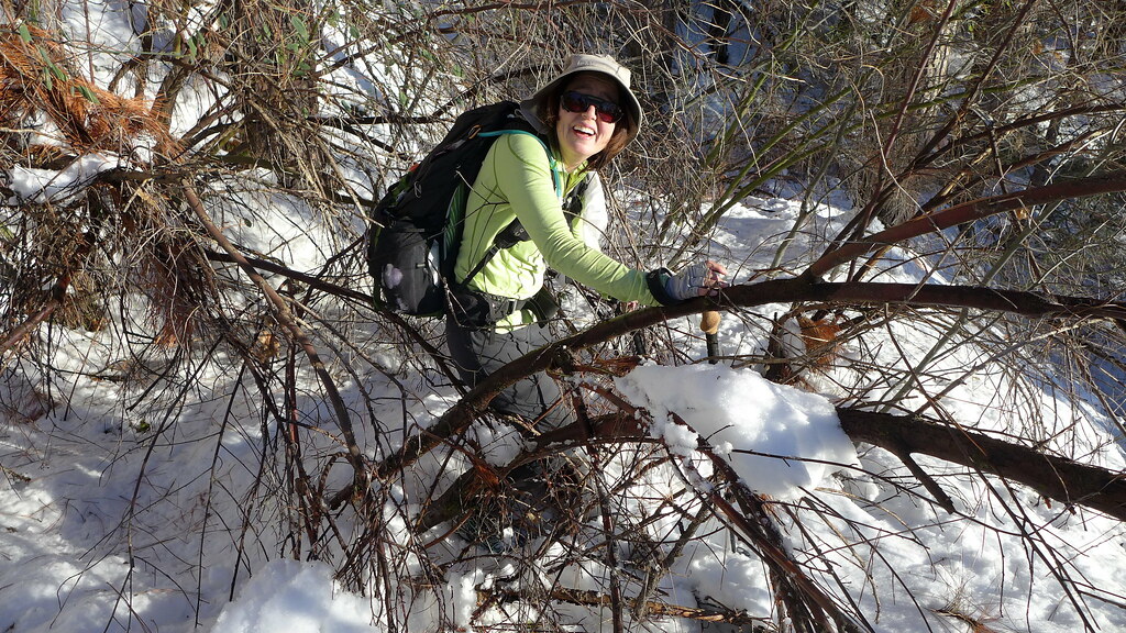
One local plant we did not enjoy seeing: poison oak. While we didn't see any examples with their leaves (of three... let them be), we saw plenty of shoots. Unfortunately, there were other very similar-looking plants that were also bare shoots, and avoiding them was impossible as the trail became overgrown. (Unfortunately, we had not brought either "Cyndi" or "Sven" along to assist with the overgrowth...)*
Although our goal for the day was a reasonable 8 miles/3000' of gain, our progress was slow due to the overgrown trail. Even without the risk of poison oak contact, there were places where pushing through the shrubbery was challenging; going so avoiding contact with anything that resembled poison oak shoots made travel all the more challenging.
At one point, we saw a small cement bunker, presumably used to store explosives used in the construction--or maintenance--of the road.
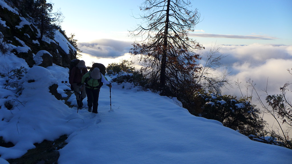
We eventually reached snow line, but at least at first it wasn't too deep--definitely not snowshoe deep.
We had read that a foot or so of snow had fallen at 8000', but we quickly were traveling through 4-5" of snow under 5000'.
As the snow got deeper, we climbed above the clouds and were once more in sunlight, although we didn't have much sun left in the day.
As sunset approached, we reached the top of the Ash Peaks ridge, where we could see Castle Rocks, Moro Rock, and the peaks of the Great Western Divide and beyond.
The road was level in this section, and after consulting our maps (3/4 of a mile to go) and watches (maybe 1/2 hour of sunlight left), we decided to stop for the night. We didn't know what our original destination would have offered, but we were satisfied with the views of our current camp.
As we set up our tent and unpacked, we enjoyed the wonderful sunset.
Below us, we could see that the entire Central Valley was shrouded by a thick blanket of fog.
On the hike up, we had been going over options for our trip, Where we landed, more or less, was that the next day we would do day hikes. The following day, being the only hiker whose poison oak sensitivity was both known and wasn't too severe, I'd head down, get a car, drive up to the Giant Forest, and... well, we'd figure something out.
The next day, after a nice pancake and bacon breakfast, we were on the trail/road. The sky was clear--at least above the fog that still concealed the lower elevations. At our elevation of just under 5000' the snow was already several inches deep. Some in our party were starting to regret the group consensus decision not to take snowshoes.
Our route still showed no signs of recent trail maintenance, but at least we didn't have to deal with poison oak or other chaparral shrubbery any more.
For a bit, we were able to take advantage of some recent trail breaking done by a bear, but eventually the bear had decided to go someplace else. The North Fork area we had started from the previous day was also under a cover of fog.
After maybe 45 minutes of walking, we reached our original first-night destination: the old Colony Mill (site) Ranger Station.
Although the structure was no longer inhabitable, parts of it were still in good condition, including some phone lines, plumbing, a hot water heater, some Wainscot siding, and even the kitchen sink.
The rangers who had been stationed here had had nice views, but we had no complaints about our campsite location and had no desire to relocate.
Past the ranger station, the road/trail seemed to be a bit better maintained, with a few more signs of cut logs and other such activity, As the trail traversed around the mountain we enjoyed many views of the high peaks above us and the fog-filled canyons below. At one point we were able to contact the park ranger and confirmed that the road to the Giant Forest was open.
Just past a curious berm in the road/trail, we saw the only trail sign we had seen since entering the park. Fortunately, it was the one sign we needed to indicate the start of our next spur.
Trail sign!
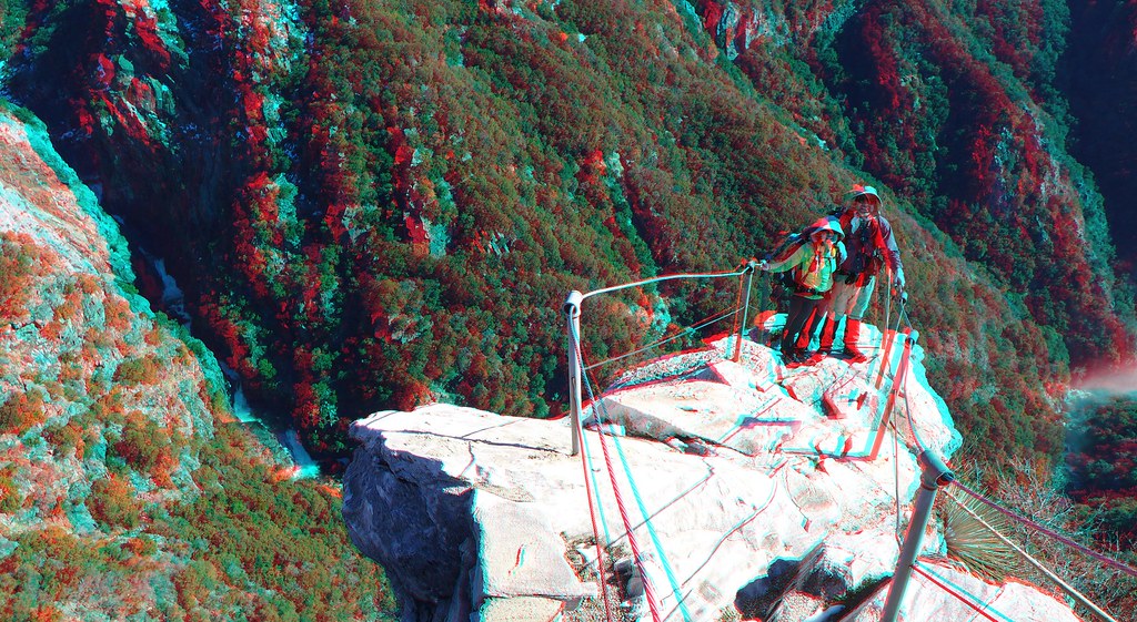
For whatever reason, the spur to Admiration Point is missing from several maps. Despite being covered in several inches of snow, we had no problems following this trail. It dropped several hundred feet in under a mile, ending at a rocky outcrop at the end.
From the protected viewpoint, we could see the complete set of Marble Falls... and the place we had been a few weeks ago, almost directly below us.
As much of the falls were still in the shade, we decided to have lunch at the viewpoint to give the sun more time to illuminate the falls. We enjoyed the warmth of the sun while peering down on the rather stagnant fog that continued to cloak the lower elevations.
After lunch we took more pictures of the better-lit falls, then packed up and headed back to the main trail.
Our goal was to hike all the way to the closed Crystal Cave road, thus completing a TrailQuest segment, but the deep snow and lack of snowshoes made our progress slow.
After reaching what we had hoped was a creek with running water, but finding that it was too cold for it to be flowing, we turned around and headed back to camp. We would need time when we got there to melt snow.
The topo map indicated a trail that looped the other way around the mountain we had been circling all day, and we had seen its junction near the ranger station, so we decided to take it on the way back. Unfortunately, it has received even less maintenance than the trails we had been following. We decided to reclassify it as "TrailQuest Extreme", but we still had to thrash our away along this long-abandoned road.
We got to camp just as the sun was setting behind a nearby hill. We enjoyed the last bits of daylight as we melted snow and got ready for dinner and retiring for the evening.
While we had trudged through snow all day and had encountered some brush, we had also had clear skies all day. Those under the fog below us had gotten no relief.
Best of all, we had made it to Admiration Point; this viewpoint was the highlight of the day.
The decision for the next day was finalized: I would hike down, get a car, drive to Giant Forest, and meet the others closer to the Giant Forest. While they would have to slog through several miles of snow, they would avoid the poison oak, any potential washouts, the fire swamp, and the ROUS's.
The next day started as it if it would be a repeat of the previous one: clear skies and the same persistent low fog. After breakfast, drying out some gear, and packing, I started my trek down the hill while the Advance Party prepared to head uphill.
I was able to see the higher parts of the trip up that had been in clouds as I descended.
On the other hand, the lower parts that had been clear a few days ago were still covered in fog.
As the Advance Party was getting into deeper snow, I left the snow completely and entered the mist.
On the way down, many of the shoots that we had thought were poison oak on the way up didn't seem like they were. Still, I tried to avoid them as best as I could, especially since they were now dripping wet due to having been in fog for the past three days.
I slowly passed from the higher, thin, bright fog to the lower, darker fog.
Near one creek crossing, concealed by large rocks on the way up, I saw a large cement bunker. One of its heavy metal-clad cement doors was still mounted, and it still opened and closed easily on its hinges despite being several decades old.
Near the trailhead I passed beneath the layer of fog. Fortunately the large washout we had encountered on the way up had not gotten any worse.
At the car I picked up a few things--most importantly, snowshoes and replacement hiking poles for someone in the Advance Party. Just before leaving the trailhead, a couple arrived in a sedan and asked if this was the road to Sequoia. At first I confirmed that it was, and that they could drive to either the Colony Mill or North Fork trailhead, but then I realized they were looking for the part of the park that normal, sane people visit. I directed them back towards the main road, and shortly thereafter went there myself.
I stopped in Three Rivers to pick up a few treats for the Advance Party then headed up to the Giant Forest. From near Potwisha I was able to reach the Advance Party on radio to let them know I had made it to the car and was on my way. Near the Eleven Range lookout area, where numerous cars were putting on chains, I confirmed with the Advance Party where I'd meet them that evening.
After putting on my snowshoes--and attaching two more pair to my pack--I headed toward our rendez-vous. The snow here was nearly a foot deep.
I reached the planned camp site before they did, and after confirming that they would be able to make it there, I stomped down snow for a tent platform, unloaded a few things, then continued towards them. My offer of a nice beverage and chips was not nearly as well received as the snow shoes I had brought them. The return to the to-be-campsite was straightforward with said snowshoes and a broken trail, but they had had a long day and were tired. We got to the campsite just as the sun set behind the hill we had camped on the previous two evenings.
The next morning, after more pancakes and bacon, we packed and returned to the car. Near the car, we passed a sequoia I had walked by on the way in. For the Advance Party, this was the first sequoia they had seen up close despite having been in Sequoia for the past three days.
Instead of returning home immediately we decided to check off a few short Giant Forest TrailQuest segments. From Beetle Rock we could see where we had spent the past few days hiking, above the still-persistent fog.
From Beetle Rock we hiked towards the old dump/water/sanitation area that dated back to when visitor accommodations were located in the Giant Forest. Near what is now a weather research station we could see Admiration Point in the distance.
We continued along a trail covered with a thick blanket of fresh snow to the Sunset Rock trailhead, where the TQ segment ended.
From there, we headed to locate the Susan B. Anthony tree, one of several named sequoias that used to be located near a road or trail but is now not signed.
After confirming its location with GPS, we returned to the car. We still had to fetch the other car from the North Fork trailhead and thus had a lot of driving left. After the previous week where the Giant Forest had been a slushy mess, and especially after several dry winters where winter travel in the forest didn't require snowshoes, it was nice to be back when there were a few feet of fresh snow. Winter--real winter--had finally returned. We were sad to leave, but we knew we'd be back soon.
* Cyndi and Sven will be featured in a future trip report.