Since the road to Buckeye Flat and the Middle Fork trailhead was still gated closed, our hike started with a nice road walk, where we had views of Paradise Creek, which we had visited a few months ago.
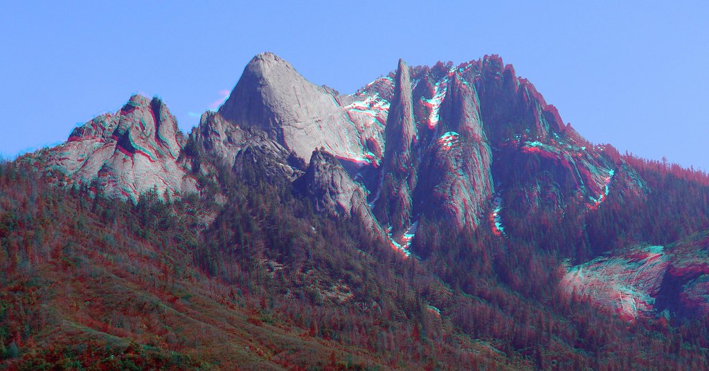
Towards the east were the high peaks of the Great Western Divide, some under many feet of snow, and others covered with a light dusting from the previous day.
One concern we had had with starting at Wolverton is that we could conceivably end up on the wrong side of several deep stream crossings. Heading the other way, the theory was that if we could cross it heading east, we could cross it again on the return trip. The first such crossing, Moro Creek, was chilly but only maybe mid-calf deep.
This was the final low-elevation SEKI TrailQuest section for JKW and the Great Pink One. I had hiked this trail many years ago, but had mostly fond memories of it and looked forward to the repeat. The trail passed through mostly low-elevation chaparral as it slowly climbed and approached the white peaks in the distance.
On a high ridge across the river from us we could see the tops of some sequoias in the remote Castle Creek grove.
Most of the first part of our hike could have been in the coastal mountains, but a few places revealed the granite that the Sierra Nevada is famous for.
To the south, we could see that we were gradually making it past the Castle Rocks.
As we neared Panther Creek, we passed a few backpackers--the first we had seen on a trail in months. The good news: Panther Creek was crossable--provided that you didn't slip and drop a shoe in the water. After a final drop we were at the Panther Creek crossing, just above the all-but-impossible-to-see waterfall.
The water here was deeper than Moro Creek, and a bit colder, but the crossing was otherwise uneventful. Just across the creek a group had hauled in, and set up, a large car-camping tent.
The temperature was quite warm as we headed to the next crossing: Mehrten Creek. Along the way, we had encountered numerous branches and trees that had fallen across the trail, a combination of wet soil, high wind, and (for the pines) death from several years of drought.
Before crossing this creek, we stopped at a place with a nice view to have lunch.
When the air was calm it was very warm, but occasionally a cool breeze would hit us. In the distance, we could see it blowing snow off the high peaks.
At one point we passed by a small rock in the trail that somewhat resembled a famous large rock to the north.
The Mehrten crossing was no worse than Panther; in fact the water may have been a bit warmer.
Just past this crossing, a large rock had very recently broken loose from the hillside above the trail, and came to rest precariously just below it.
Our next interim destination was Buck Creek, which fortunately would be bridged. We could also just make out where Redwood Meadow grove was.
A large granite wall marked Buck Creek, and eventually the trail dropped below it.
There is a well-developed trail-side campsite just past the Buck Creek bridge, but we still had a few hours of daylight, and we didn't want to be in a canyon where the sun would set early and rise late and the air would be cool, so we pressed on.
Perhaps because there were no sequoias to "boop" and very few trail signs, it had become a thing to call "Found it!" every time we could see Moro Rock--which was basically every time we turned around and looked behind us.
We eventually decided it was time to start looking for a campsite, and the map suggested a nearby ridge might have promise. At higher elevations this would almost always have been true, but in mid-elevation chaparral, well, we were lucky to find a small break in the manzanita and oak to set up our tent.
On the plus side, we would get as much sun as the day had to offer, we'd be among the first to experience the morning's rays, and Moro Rock was visible in the distance.
After a mild night's rest, a warm sunny morning, and a good breakfast, we headed out for a day hike. We almost immediately entered a more heavily wooded area that had a lot of deadfall.
We shortly reached the Bearpaw/Redwood Meadow trail junction and starting the climb towards the former. The trail soon topped out on a ridge with nice views of the now much-closer Great Western Divide. The cool breeze from the previous day was all but gone, and the climb was quite warm.
There were patches of snow, but what slowed us down were all the limbs and logs that had fallen across the trail.
Just below Little Bearpaw Meadow, we put on our snowshoes for the first time. All it took was maybe 100' of snow to go from thin and patchy conditions to several feet of 100% coverage..
We checked out Little Bearpaw itself, but decided to defer the climb to (Big?) Bearpaw for another day. The snow was sufficiently deep that we would have had a hard time proving, at least to the satisfaction of the TrailQuest judges, that we were actually following the trail.
Instead, we followed the faint tracks of a recent party, and the less-faint tracks of a more-recent party, down to the Middle Fork.
We were now much closer to the snow-capped peaks of the Great Western Divide, but there were enough trees that views were only occasional. One of them provided glimpses towards Valhalla, Angels Wings, and the Hamilton Lake area.
On the floor of the valley we passed by the stump of an old post--perhaps a marker for an old junction with a trail that some old maps indicated may have existed...?
We stopped for lunch just before the Middle Fork crossing. The present-day ford was near an old abutment that was the only sign of a former bridge. Fortunately, in this area the flow split into a few different channels, and none looked too swift or deep. After we were finished with our chicken* and mashed potatoes, we crossed the river.
Past--and perhaps recent--floods had caused the river to cut a deep channel in the otherwise flat valley floor, in one place leaving a tree's thick root hanging many feet over the river below it.
After a nice, mostly level stroll, we eventually reached the junction with a "bypass" trail, one I had taken on my trip to Redwood Meadow. Back then, the trail sign had almost been demolished by a large tree that had just fallen; since then someone had relocated it.
Despite this year having record snowfall, I had encountered more snow in this area when I had been here previously. No complaints, and after the short Eagle Creek crossing, we were soon at the Granite Creek bridge.
Past this bridge, the snow-covered trail traversed high above Granite Creek.
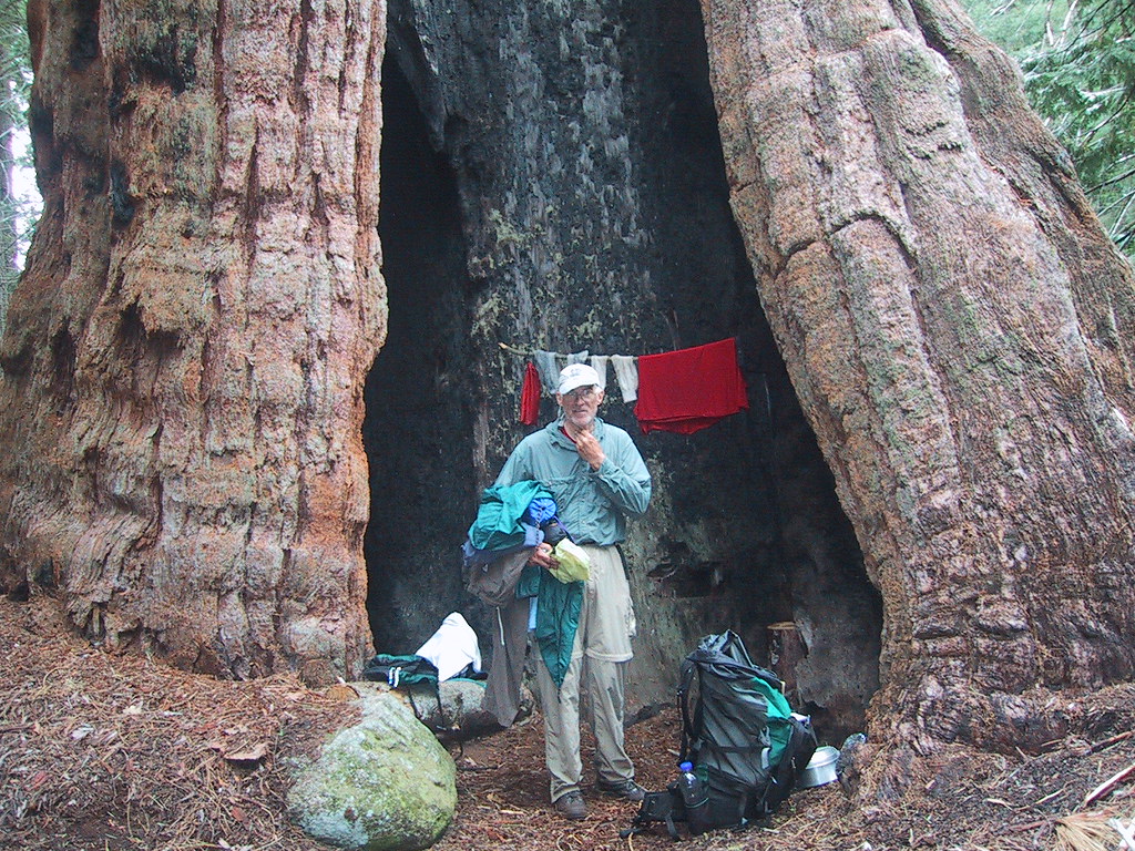
In not too much time we left this snow behind and were soon booping sequoias.
Redwood Meadow grove is much smaller than Redwood Mountain, Garfield, or the Giant Forest, but it does have several large sequoias.
We took a short side trip to check out the closed ranger station and corrals.
We unfortunately still had more TrailQuest mileage to check off, so we couldn't linger in the grove for too long, but we did pass a few large trees on the way out.
Although there was a bridge at the upper crossing of Granite Creek, the one at the lower crossing had washed out years ago and hadn't been replaced. When I was last here a log provided an alternative to fording the creek, but that log was nowhere to be seen, so we had to wade across its deep, swift waters.
Whatever had caused the old bridge to wash away had raised the creek many feet; the old abutments were high above the water.
Before returning to our tent, there was one more section of trail we (well, they) needed to do, so we climbed back up to the junction we had passed a few hours earlier, then retraced our steps back, before continuing across the Middle Fork. The Middle Fork bridge had also seen some damage, but was still in service.
We had one final climb on our way back to the tent, but the views provided sufficient distraction.
We eventually reached the Bearpaw/Redwood Meadow junction and were officially done with all the TrailQuest in this area--although we will still have to return to Redwood and Bearpaw Meadows from other directions to finish more trails.
We got to our tent with just enough light to unpack and get in before it was dark.
We also located Moro Rock one last time for the day.
The night had been even more mild and the morning was downright warm. After breakfast, we packed up our camp and began our hike back to the trailhead. It would be much easier to "find" Moro Rock hiking in this direction.
The snow on the high peaks behind us glistened under the sun that was getting warmer and warmer.
Although the endless snow and rain made it seem like winter would never end, to some flowers along the trail it was already spring.
As we descended, we were glad that we were not attempting this route in late spring or summer.
A bit before Panther Creek, JKW found a sleeping bag in its stuffsack with no owner nearby. Fortunately, we ran into said owner at Panther and were able to return the misplaced item.
Eventually we were looking straight across at Castle Rock; our trailhead was nearby.
As we neared Moro Creek we could see that the parking lot was empty; the Buckeye Flat road was still closed.
We had changed into water-crossing shoes at all wet crossings, but as Moro Creek was our final crossing, we kept our winter boots/shoes on, hoping that the 2 mile road walk would give them a chance to dry out a bit.
At the trailhead we stopped for a snack and looked back at where we had been.
Our shoes were still squishy wet when we got to Hospital Rock, but we didn't care. It had been a great trip, and we had knocked off some hard-to-reach TrailQuest segments.
* Don't worry, no stuffed chickens were harmed in the making of this meal.