
The Moon is Waxing Gibbous (85% of Full)
Re: Snow Creek
All posts are those of the individual authors and the owner
of this site does not endorse them. Content should be considered opinion
and not fact until verified independently.
May 12, 2017 10:19PM | Registered: 8 years ago Posts: 28 |
Will crampons be necessary/a good idea for the snow creek trail to Watkins in June mid June? We want to do some off trail trekking, I'm well aware of the snowpack this year, just want to know an estimate of what to expect between 7000 and 8000' around then. Beyond the potentially formidable creek crossings, should snow also be something to prepare for?
May 12, 2017 10:49PM | Moderator Registered: 15 years ago Posts: 2,321 |
Some sort of traction device is in order, maybe even small snowshoes. Look at the snow pillow at Tenaya Lake (8k') to judge the amount of snow at Waskins 8.5K')
http://cdec.water.ca.gov/jspplot/jspPlotServlet.jsp?sensor_no=8246&end=&geom=&interval=&cookies=
This plot shows water content and the snow depth is about twice that.
Old Dude
http://cdec.water.ca.gov/jspplot/jspPlotServlet.jsp?sensor_no=8246&end=&geom=&interval=&cookies=
This plot shows water content and the snow depth is about twice that.
Old Dude
May 13, 2017 07:17AM | Moderator Registered: 14 years ago Posts: 7,421 |
Honestly... I would never bring Crampons to Watkins regardless of route
(ok, MAYBE if not staying near the the trail... but )
Probably people sick of me saying this...
But in 2011... Last BIG snow year... I went up Snow.. all the way past Tenaya Lake
to Cathedral Lakes ... and around ... yadda yadda... in Mid June...
I didn't bring any traction devices...
The temps get high enough that the snow is pretty nice to walk on by then...
My crap TR was here:
http://yosemitenews.info/forum/read.php?3,39233,39233#msg-39233
Pics link no worky ... here's fixed link:
https://photos.google.com/album/AF1QipOrdq4kQLXyvbaj7QLxMX83HRABx7tH_1XLTvft
If you are only going to Watkins and back down... then I'd bring my flippers and
that's it... I can comment more if you say more of what your plan is...
Also, if you are heading towards Tioga... towards Quarry... can you take a pic
of the BIG ROCK next to the trail... I'd like to see it...
Its' about here:
https://mappingsupport.com/p/gmap4.php?ll=37.805104,-119.513784&z=14&t=t4
Thanks
May 13, 2017 09:06AM | Moderator Registered: 15 years ago Posts: 2,321 |
May 13, 2017 11:34AM | Registered: 8 years ago Posts: 28 |
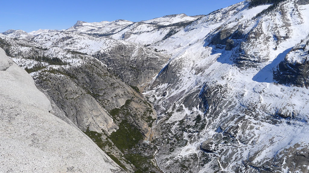
We want to get a glimpse of Pywiak cascade from Mt Watkins, thinking it's guaranteed to have some impressive flow. After that the decision will be to either press up to Olmsted point, and then tenaya lake, or to circle around Indian ridge and follow along lehamite creek back down to the rim and descend back into the valley. I'd personally love to see what tenaya lake will look like at this time. I just don't want to be naive about what footwear might be needed, or how passable the creek crossing between the quarries and Olmsted might be.
May 13, 2017 11:44AM | Registered: 8 years ago Posts: 28 |
May 13, 2017 03:28PM | Moderator Registered: 14 years ago Posts: 7,421 |

May 13, 2017 03:46PM | Moderator Registered: 14 years ago Posts: 7,421 |
If you are talking this creek:
https://mappingsupport.com/p/gmap4.php?ll=37.810732,-119.498592&z=14&t=t4
I wouldn't worry toooo much about that other than you will probably wonder why you
decided to go that-a-way.. when you could have just hiked the road probably...
considering that it is probably plowed by then but not open to regular car traffic...
if you get sytmied you can go up to the road and use it to cross that creek.
I did that one year... when I got sick of flopping around in the woods...
Also if you do want to stay on the trail... um... yeah, don't probably...
this here:
https://mappingsupport.com/p/gmap4.php?ll=37.795677,-119.506660&z=14&t=t4
is crazy steep and I was literally hanging onto some Manzanita once...
saying "well, that was smart... "
obliviously go off the trail and either take the ski route up to Quarry
or go up and over saddly here:
https://mappingsupport.com/p/gmap4.php?ll=37.797237,-119.509664&z=14&t=t4
you do know you can see pywiak from glacier point webcam?
Also, you can see from trail here:
https://mappingsupport.com/p/gmap4.php?ll=37.793507,-119.508205&z=14&t=t4
from Watkins itself you have to go WAY out...
I'd recommend going out Wasoo ...
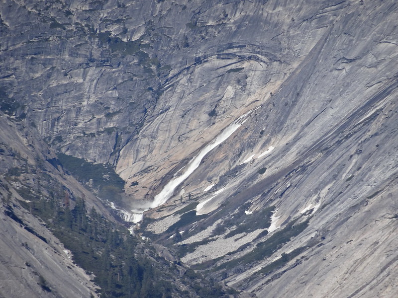
then you can peer down into Tenaya Canyon and also see the other waterfall in the canyon
go here:
https://mappingsupport.com/p/gmap4.php?ll=37.783604,-119.508033&z=14&t=t4
and see this:
June 18, 2013

Feb 2012 (very low snow year)
anyway, yeah, I hear you about wanting to see Tenaya Lake..
getting across and then over and then coming down Forsyth Trail
(going up and over Clouds Rest will be interesting.. I wouldn't
recommend too much... ) ..
plus... just crossing Sunrise Creek was very interesting in April this year...
I'd really recommend going to Watkins and Wasoo and enjoy
and beyond that... I dunno.. Indian Ridge is safer and is just fabulous
Anyway, have fun and be safe
I probably wasn't too clear at the end there...
hmm... Ok, not too bad a look at Pywiak from Watkins...
Can see in my set from April of 2011
https://photos.google.com/album/AF1QipOdkG5AAyvtj9sfZwcte3qs0YURaSx5v3gLaU6F
Ask more but I won't be back until May 21
Have fun
https://mappingsupport.com/p/gmap4.php?ll=37.810732,-119.498592&z=14&t=t4
I wouldn't worry toooo much about that other than you will probably wonder why you
decided to go that-a-way.. when you could have just hiked the road probably...
considering that it is probably plowed by then but not open to regular car traffic...
if you get sytmied you can go up to the road and use it to cross that creek.
I did that one year... when I got sick of flopping around in the woods...
Also if you do want to stay on the trail... um... yeah, don't probably...
this here:
https://mappingsupport.com/p/gmap4.php?ll=37.795677,-119.506660&z=14&t=t4
is crazy steep and I was literally hanging onto some Manzanita once...
saying "well, that was smart... "
obliviously go off the trail and either take the ski route up to Quarry
or go up and over saddly here:
https://mappingsupport.com/p/gmap4.php?ll=37.797237,-119.509664&z=14&t=t4
you do know you can see pywiak from glacier point webcam?
Also, you can see from trail here:
https://mappingsupport.com/p/gmap4.php?ll=37.793507,-119.508205&z=14&t=t4
from Watkins itself you have to go WAY out...
I'd recommend going out Wasoo ...
then you can peer down into Tenaya Canyon and also see the other waterfall in the canyon
go here:
https://mappingsupport.com/p/gmap4.php?ll=37.783604,-119.508033&z=14&t=t4
and see this:
June 18, 2013
Feb 2012 (very low snow year)
anyway, yeah, I hear you about wanting to see Tenaya Lake..
getting across and then over and then coming down Forsyth Trail
(going up and over Clouds Rest will be interesting.. I wouldn't
recommend too much... ) ..
plus... just crossing Sunrise Creek was very interesting in April this year...
I'd really recommend going to Watkins and Wasoo and enjoy
and beyond that... I dunno.. Indian Ridge is safer and is just fabulous
Anyway, have fun and be safe
I probably wasn't too clear at the end there...
hmm... Ok, not too bad a look at Pywiak from Watkins...
Can see in my set from April of 2011
https://photos.google.com/album/AF1QipOdkG5AAyvtj9sfZwcte3qs0YURaSx5v3gLaU6F
Ask more but I won't be back until May 21
Have fun
May 22, 2017 06:23AM | Moderator Registered: 14 years ago Posts: 7,421 |
Sorry I wasn't trying to be mean or anything to Old Dood.
In simple terms. Crampons: No
Microspikes: Why not?
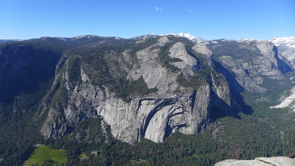
Looking from Glacier Point... I'd opt for the up Watkins then back down and around to Indian Ridge.
Most of North Rim will be clear by the time you go... and Porc pine Creek falls should be amazing.
As I think I stated... you can see Pywiack from Glacier point (from this friday)
You can see how little snow there actually is on your route up to Watkins... and where it starts on Indian Ridge...
Here you go...
Have fun
In simple terms. Crampons: No
Microspikes: Why not?
Looking from Glacier Point... I'd opt for the up Watkins then back down and around to Indian Ridge.
Most of North Rim will be clear by the time you go... and Porc pine Creek falls should be amazing.
As I think I stated... you can see Pywiack from Glacier point (from this friday)
You can see how little snow there actually is on your route up to Watkins... and where it starts on Indian Ridge...
Here you go...
Have fun
Sorry, only registered users may post in this forum.

