I'm hoping someone on here might have either coordinates or map with the location/route of the trail that starts/ends at the double bridge and runs to Pothole Dome. We are doing a 9 day trip starting this weekend and we are considering adding a side loop up Murphy Creek and then south towards Tuolumne and Cathedral Lakes. I've never taken this trail before and would appreciate any beta/info anyone is willing to share, thanks!
I've been told that this trail will save a couple miles as well as avoid the worst of Tuolumne Meadows.
Edited 1 time(s). Last edit at 07/10/2017 07:14PM by Creakyknees.

The Moon is Waxing Gibbous (61% of Full)
Re: Glen Aulin Pothole Dome Use Trail, Need Info.
All posts are those of the individual authors and the owner
of this site does not endorse them. Content should be considered opinion
and not fact until verified independently.
|
Glen Aulin Pothole Dome Use Trail, Need Info. July 10, 2017 07:13PM | Registered: 6 years ago Posts: 15 |
|
Re: Glen Aulin Pothole Dome Use Trail, Need Info. July 10, 2017 09:12PM | Registered: 13 years ago Posts: 1,425 |
From Glen Aulin, when you get to the top of the big climb, and just before you cross the bridge to the North side of the river, there is a use trail that goes off to the right, staying on the South side of the river for a while, and then eventually over to Tioga Road at Pothole Dome. Hard to miss from that direction.
Check our our website: http://www.backpackthesierra.com/
Or just read a good mystery novel set in the Sierra; https://www.amazon.com/Danger-Falling-Rocks-Paul-Wagner/dp/0984884963
Check our our website: http://www.backpackthesierra.com/
Or just read a good mystery novel set in the Sierra; https://www.amazon.com/Danger-Falling-Rocks-Paul-Wagner/dp/0984884963
July 10, 2017 09:57PM | Moderator Registered: 14 years ago Posts: 7,421 |
Look here:
http://yosemitenews.info/forum/read.php?3,26056,26078#msg-26078
It goes over granite in places and since you have never been... you
MAY lose the trail here and there...
It's not a huge savings on account you have to walk from Pothole to the Cath Lakes trailhead.
Maybe a bit. Maybe a not.
And sorry about all the broken pix and all here and there.
I used google photos and this that and the other...
Anyway, if not enough info... ask for more.
July 10, 2017 09:58PM | Moderator Registered: 14 years ago Posts: 7,421 |
July 11, 2017 05:04AM | Registered: 11 years ago Posts: 269 |
There is an obvious trail through the meadow chick-on mentioned but kinda hard to see if it's underwater. Once on the other (east) side of the meadow you'll want to stay somewhat to the left (north) to pass through the forested area between Pothole and the river. Once in the forested area you may find multiple "trails" that wander for a while and then just taper out. No need for a trail there, just keep heading east, keep Pothole on your right and the river on your left and eventually you will come out to the main large meadow at TM. This forested area takes longer to get through than it might seem it should just from looking at a map. As you begin to come around Pothole you'll see that you can start veering right (south) around Pothole. Once at the big main TM meadow you should pick up a trail (if it's not underwater) that you can follow south along the base of Pothole and loop back up to Tioga Rd.
|
Re: Glen Aulin Pothole Dome Use Trail, Need Info. July 11, 2017 06:42AM | Registered: 13 years ago Posts: 1,425 |
There is a newer option to the trail through the meadow that stays in the trees to the south of the meadow...if you are interested
Check our our website: http://www.backpackthesierra.com/
Or just read a good mystery novel set in the Sierra; https://www.amazon.com/Danger-Falling-Rocks-Paul-Wagner/dp/0984884963
Check our our website: http://www.backpackthesierra.com/
Or just read a good mystery novel set in the Sierra; https://www.amazon.com/Danger-Falling-Rocks-Paul-Wagner/dp/0984884963
July 11, 2017 07:41AM | Registered: 13 years ago Posts: 1,351 |
|
Re: Glen Aulin Pothole Dome Use Trail, Need Info. July 11, 2017 06:05AM | Registered: 6 years ago Posts: 15 |
July 11, 2017 07:09AM | Moderator Registered: 14 years ago Posts: 7,421 |
To be more clear:
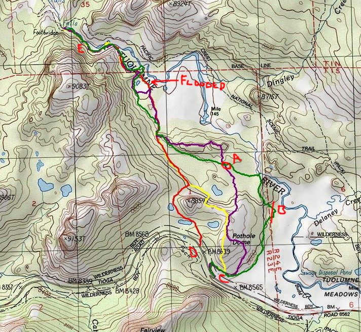
You'll probably run into a bunch of trails.
E is little devils postpile.
D is kinda where most start ....
Anyway... Use as you wish. I prefer the purple. But worth it to
check out the river on the green ish.
The trail at the end is not flooded. DO NOT walk thru the meadow there.
STAY on the TRAIL near the main TM.
Have fun
O... so what exactly is your entire route? Can maybe comment.
|
Re: Glen Aulin Pothole Dome Use Trail, Need Info. July 11, 2017 11:30AM | Registered: 6 years ago Posts: 15 |
|
Re: Glen Aulin Pothole Dome Use Trail, Need Info. July 11, 2017 12:45PM | Registered: 15 years ago Posts: 384 |
I've been occasionally using that route for decades and it is just that a route and not a trail although one will see many use paths in places. The wiser strategy is not to expect to stay on some trail but rather use a cross country strategy, hiking on use paths if they happen to be there. In other words know where you are going instead of trying to follow a trail or cairns piled by the clueless. A lot of the use paths are from deer that are abundant in those areas. The E section on co's map is awkward up and down on a dense lodgepole pine slope. As co related stay off the meadows that now are certain to be soggy. I tend to use the red route and park north of the main Pothole Dome dirt pullout.
Also the 9083 dome area is a fine place to explore with outstanding views that I've never seen others at.
David
http://www.davidsenesac.com
Edited 1 time(s). Last edit at 07/11/2017 12:47PM by DavidSenesac.
Also the 9083 dome area is a fine place to explore with outstanding views that I've never seen others at.
David
http://www.davidsenesac.com
Edited 1 time(s). Last edit at 07/11/2017 12:47PM by DavidSenesac.
July 11, 2017 01:59PM | Moderator Registered: 14 years ago Posts: 7,421 |
|
Re: Glen Aulin Pothole Dome Use Trail, Need Info. July 11, 2017 01:49PM | Registered: 6 years ago Posts: 15 |
We are considering primarily two different routes. Alot will just depend on how my kids are feeling. They are 18 and 16 and have done some significant backpacking but this will be their longest trip. They also tend to enjoy stopping more, exploring, messing around, like normal teenagers so planning can sometimes be a little difficult but it is worth it to see their love of the outdoors blossoming.
We have a permit leaving May Lake>Snow Creek trailhead July 15th and finishing at Tunnelview July 22nd which gives us 8 days.
Proposed Route 1 (Longer/more mileage)
Day 1 - May Lake>Snow creek trailhead to Mount Watkins, camp Mount Watkins. (1st day is the same for both trips and short to allow a little more time to acclimatize.)
Day 2 - Leave Mt. Watkins join trail to Olmsted then Murphy Creek trail north to Glen Aulin/White Cascade area, camp nearby.
Day 3 - Head south to Cathedral Lakes trailhead (the reason I was asking about Pothole Dome trail) cross Tioga Rd at Pothole Dome to join trail on south side of Tioga then east to Catheral Lakes trailhead and south to Cathedral Lakes, camp Cathedral Lakes.
Day 4 - Cathedral Lakes to Sunrise Lakes to Clouds Rest, camp near Clouds Rest.
Day 5 - Clouds Rest to Echo Valley then west to Bunnell Cascade, camp near Bunnell Cascade.
Day 6 - West to LYV, then Nevada Falls, Vernal Falls, Panorama Trail, and then south along Illilouette to camp.
Day 7 - Back up Illilouette to Glacier Point and Pohono Trail, camp west of bridge over Bridelveil Creek. (only legal spot)
Day 8 - Finish Pohono to Tunnelview
This plan ends up being around 10 miles a day which doesn't seem to bad but the big question mark was the day from Glen Aulin to Cathedral Lakes.
Proposed Route 2 (shorter mileage)
Day 1 - May Lake>Snow creek trailhead to Mount Watkins, camp Mount Watkins. (1st day is the same for both trips and short to allow a little more time to acclimatize.)
Day 2 - Leave Mt. Watkins join trail to Olmsted then Sunrise Lakes trail to Sunrise Lakes, camp Sunrise Lakes.
Day 3 - Sunrise Lakes to Clouds Rest, camp near Clouds Rest.
Day 4 - Clouds Rest to Echo Valley then west to Bunnell Cascade, camp near Bunnell Cascade.
Day 5 - Hike to LYV, use bear lockers and go hike Liberty Cap, camp LYV.
Day 6 - Leave LYV, hike to Nevada Falls, Vernal Falls, Panorama Trail, and then south along Illilouette to camp.
Day 7 - Back up Illilouette to Glacier Point and Pohono Trail, camp west of bridge over Bridelveil Creek. (only legal spot)
Day 8 - Finish Pohono to Tunnelview
Please feel free to provide any input or ideas! This is my first trip to Yosemite and I'm so excited. It will also probably be one of my daughters last trips for a while (leaving for college).
Edited 1 time(s). Last edit at 07/11/2017 01:50PM by Creakyknees.
July 11, 2017 02:02PM | Moderator Registered: 14 years ago Posts: 7,421 |
|
Re: Glen Aulin Pothole Dome Use Trail, Need Info. July 14, 2017 08:12AM | Registered: 13 years ago Posts: 693 |
Probably too late...the Pothole Dome trail is clear all the way to the twin bridges. Just have to skirt the flooding in the meadows. I used the lower most trail. I believe the main trail is OK too, because lots of hikers yesterday. But parking was not available between Lembert parking and the stables.
Sorry, only registered users may post in this forum.

