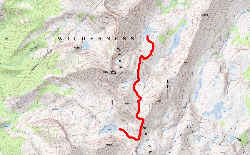
Day one- mono meadow to grayling lake. Day 2-up to Lake 10245, take ridge toward grey peak and drop into Adair/GPF. Follow GPF to obelisk outlet and up to obelisk. Next day west side of GPF down to Merced. August 2018. Is it possible to take the ridge into Adair from lake 10425. Class 2?
Also how difficult is the west side of GPF to Merced? I've seen posts suggesting it's easier to go over to RPF to get down to the Merced. Looks like it adds about 4 miles to go over to RPF. I was hoping for 3 nights and 4 days. Hiking out to glacier point and hitching back to mono meadow.
All posts are those of the individual authors and the owner
of this site does not endorse them. Content should be considered opinion
and not fact until verified independently.
|
Grey peak ford to Merced lake? February 24, 2018 06:42PM | Registered: 6 years ago Posts: 31 |
|
Re: Grey peak ford to Merced lake? February 25, 2018 09:27AM | Registered: 10 years ago Posts: 184 |
Quote
Yosemrick
August 2018. Is it possible to take the ridge into Adair from lake 10425. Class 2?
Also how difficult is the west side of GPF to Merced? I've seen posts suggesting it's easier to go over to RPF to get down to the Merced. .
Never been to Greyling but have tried the RPP route - 10425 to Adair...doable but stayed high and left and had "cliffed out" and talus issues that slowed us down some...Was not a fun traverse.
Easier was following the Red Devil drainage down and crossing over in the gap just east of lake 9705...3 hours from Red Devil Lake to Adair..
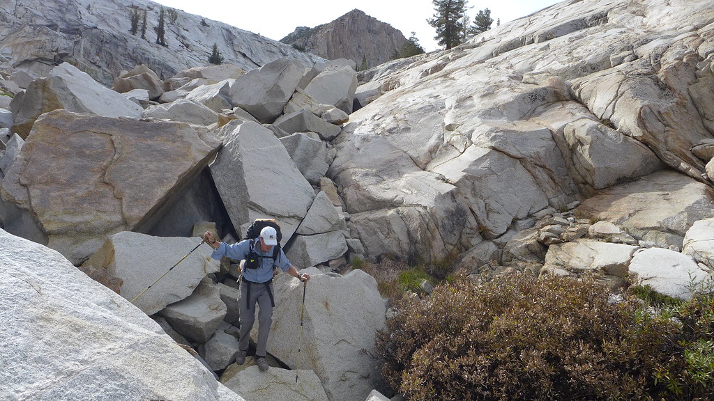
Coming down from Adair or Obelisk - the GPF was easy to start out. (Supposed to be an old cavalry trail but we somehow missed it.) We followed the GPF down till about 8,400' and the final descent to Merced...ran into about 1,000 feet of Manzanita - 10-foot walls...steep, broke a hiking pole, got scratched up some, and swore a lot - but do-able.
The next time we tried going the RPF route instead - (crossed over from GPF to RPF just south of/ followed the obvious gap up below peak 9658) and was lots better. Easy, fun route finding down to the RPF canyon. Crossed the Merced River and rejoined the trail about 1/2 mile above Washburn. Recommended!.
|
Re: Grey peak ford to Merced lake? February 25, 2018 11:33AM | Registered: 10 years ago Posts: 184 |
To add - might be quicker?
One of the times we were at Obelisk, a third member, who had joined us at Red Devil, took a more direct way out. From Obelisk, first north, then west, crossing over the saddle just south of Quartzite Peak.
His map (I looked) then showed him following the Clark Canyon drainage down, but soon, a bit westerly, joining the main trail again (south of the Merced), somewhere after the Echo Valley bridges and above the 14 switchbacks going down to Bunnell Cascades.
Talked to him later, said no problems.
|
Re: Grey peak ford to Merced lake? February 25, 2018 07:05PM | Registered: 6 years ago Posts: 31 |
February 26, 2018 07:35AM | Moderator Registered: 14 years ago Posts: 7,421 |
Ur hiking profile says... intermediate...
???
What exactly is your goal? Have you done all the trails yet?
Do you want to see 10,425? Go up Red Peak? Go up Grey?
(Grayling is not a super spectacular lake) (someone put a register there...
and the 2nd guy found it necessary to Debbie Downer it... and write
"hard to find... easy to forget" ... yeah.. ok... thanks... whatever)
(but yeah... higher is more spectacular. )
I'm never sure what exactly people mean with route discripts at times...
a simple map drawn on it would make things clear.
Like how far towards Grey? It's knife edge in spots. Easy in some. Impossible in others.
How good are you reading map? Reading terrain?
We have gone literally up and over Grey. It's steep ... but was "easy" ... other spots...
not so much.
August... yeah... should be able to "easily" get from Adair to Obelisk ... but again,
intermediate? I dunno. We had no issues going from Clark Canyon ... up Mt. Clark...
the over to Adair and above... next day over to Red Devil... over RPP... camped at Lower Ott.
Out Mono last day.
Honestly, not trying to give you a hard time.
There's loads of ways over the Clark Range... And we absolutely LOVED the old cavalry
trail (it didn't go TO Obelisk) ... but then again, we are into old trails... and I've yet
to meet a shrub I didn't like...
I probably didn't help you much.
February 26, 2018 11:08AM | Moderator Registered: 14 years ago Posts: 7,421 |
fwiw
blops TR up Clark Canyon and down Obelisk etc..
https://yosemitenews.info/forum/read.php?17,82008,82008#msg-82008
blops TR up Clark Canyon and down Obelisk etc..
https://yosemitenews.info/forum/read.php?17,82008,82008#msg-82008
|
Re: Grey peak ford to Merced lake? February 26, 2018 07:01PM | Registered: 6 years ago Posts: 31 |
Thanks "chick-on". I enjoy reading your posts. I have been taking annual backpacking trips to Yosemite for six years in a row with most trips 4 or 5 nights. I lived in LA area for about 10 years but now I'm in the mid west. This year I am leading a few friends on a trip to ten lakes. 2 nights at ten lakes and two at grant. I've seen your posts and hope to checkout grand mtn and a couple other smaller summits in the basin. I love to fish and tend to take more photos than most people are comfortable with.
I am looking for a second 3-night 4-day trip after ten lakes. I'd like to make it to obelisk. I have a permit for mono meadow and hope to make it to lake 10425 the first day. 2nd day-If I could get up and over to Adair...follow GPF down to obelisk outlet and up to obelisk. I have see posts showing the route down from Adair and up to obelisk.
I'm not sure how to post a map. I am 55 so I'm tecno challenged
I originally thought I could go up to the saddle east of 10425 and follow the ridge north eventually "dropping" into Adair/GPF "canyon". I'm not sure how exposed or difficult that ridge is. Would it be easier to go northeast from 10425 to one of the two saddles before grey and then down to Adair? This would be with an exos 58 pack and about 32 lbs of gear.
Based on markskor's post I should be able to get down to the Merced at echo valley. Which is similar to the route you took up to obelisk. It looks like the main trail crosses the river below the echo valley junction so that must be Where the twin bridge is?
February 26, 2018 08:58PM | Moderator Registered: 14 years ago Posts: 7,421 |
The two (Twin? ... ok...) are here:
https://mappingsupport.com/p/gmap4.php?ll=37.743927,-119.461255&z=15&t=t4
So... 13.5 miles... 4,500 ft. climb on day 1. ok
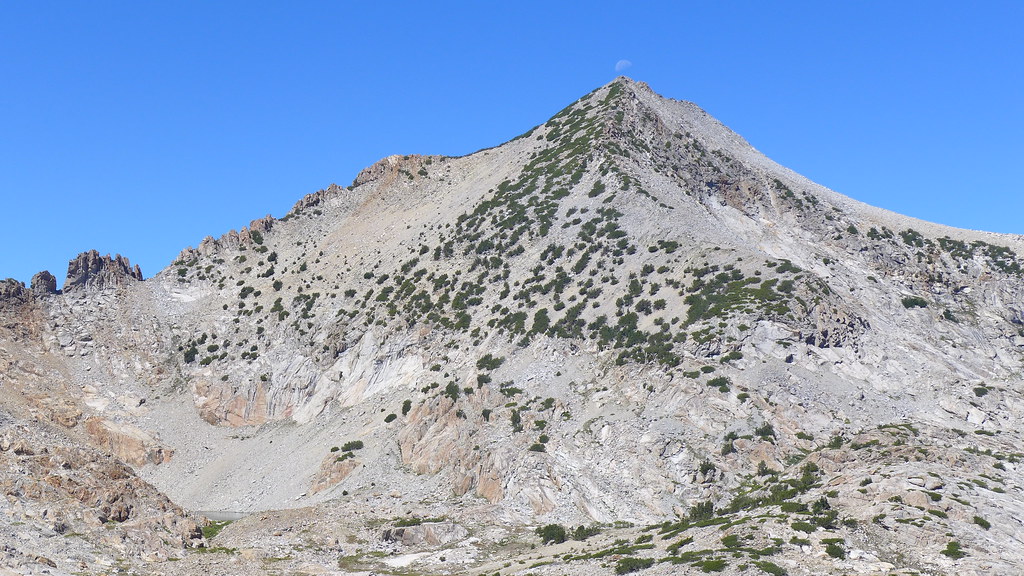
Here's view of 10,425 from Gray...
When I went up Red Peak (from RPP) ... I dropped to 10,425 then went down to Grayling...
So... lots doable.
Still concerned with "intermediate" ... just saying
You have until August
Lots doable that doesn't look like on map...
So you needs to be able to read terrain and have fun exploring...
We came down from where the moon is... on one trip...
Be safe (and tell me you've done Red Peak Pass)
https://mappingsupport.com/p/gmap4.php?ll=37.743927,-119.461255&z=15&t=t4
So... 13.5 miles... 4,500 ft. climb on day 1. ok
Here's view of 10,425 from Gray...
When I went up Red Peak (from RPP) ... I dropped to 10,425 then went down to Grayling...
So... lots doable.
Still concerned with "intermediate" ... just saying
You have until August
Lots doable that doesn't look like on map...
So you needs to be able to read terrain and have fun exploring...
We came down from where the moon is... on one trip...
Be safe (and tell me you've done Red Peak Pass)
|
Re: Grey peak ford to Merced lake? February 27, 2018 04:53PM | Registered: 6 years ago Posts: 31 |
I'm not sure what the hiking categories are? I'm not at the super chick-on level. No disrespect. I research the hikes during the winter months and always find your posts.
Never carried a rope but might have needed it once or twice. Some of my adventures-cathedral to sunrise camp...yes the first year I went I was one of those HSC folks. I picked up cancellations and strung together two nights at sunrise, with one night at Merced and VG. Loved it. Day hiked to clouds rest from sunrise. Next day went off trail following the stream from sunrise between the twin "peaks" down to echo creek and Merced HSC. Next day up lewis Ck to Bernice lk, VG pass over to HSC and a pre- dinner hike up to basket and the other lakes on the way. Next day Evelyn and down Lyell to TM.
Year two we went back to VG and day hiked parsons peak and the area around Ireland and Evelyn. High trail to thousand island lake the third year. Day hiked to davis lakes- fishy fishy. Some nice off trail adventures from Davis and a glimpse at the biggest stag I've seen in the California mountains. Hiked over to shadow creek, day hikes to Ediza, iceberg and Cecile and nydiver. Next year saddlebag over secret pass to upper McCabe, day hike to Roosevelt then Down to GA. Day hike to waterwheel and return creek bridge. Also went to upper young lake that year from TM. Mt conness summit from young lakes. Mt Hoffmann day hike from may lake trail.
Emigrant/Crabtree TH last year. Camped at grouse, then Gem. Jewelry, deer, buck and camped at wood. Day hike from wood to Karl's, leighton,five acre, yellowhammer, big,missed pingree, kole back to wood.
I've done 1/2 dome twice once back in the early years before permits were need and without the cable posts installed. Day hiked to top of yosemite falls, down Tenya canyon to the falls, and El Capitan from tamarack creek.
I have not done red peak pass/Ottoway but it's on my list. One of my hiking buddies has trouble getting more than 4 days and the red peak pass trail looks like at least 5 to really enjoy it.
This trip to 10425 is somewhat of a scouting trip for a trip to lower Ottoway.
This started with Bob Burds post for submitting Red peak from 10425. I'm not a peak bagger but If I can make it without ropes and hand holds I'm game. No plans to summit Red, Grey, or Clark. The target is obelisk. Not sure I will make it to 10425 on the first day with a full pack but I will give it a try.
Your photo of 10425 from grey peak shows the ridge (on the left) that I'm hoping to go into Adair from. Definitely has the scree look to it but hopefully doable and not too loose.
February 27, 2018 07:57PM | Moderator Registered: 14 years ago Posts: 7,421 |
No problem.
Don't want to say it's easy and then you're just pissed at me.
You may enjoy these. I kinda quit doing photo sets.. on account go nearly
every weekend and take 100s of photos each trip and yadda yadda yadda..
That and Google screwed up picasa
Hopefully these work:
Red Peak
https://photos.app.goo.gl/58rwPJ6pwZzdRh6D3
3 day trip
Mono Mdw TH - Red Peak - 10,425 - Grayling - Mono Mdw TH
Obelisk (from Happy Isles) (up Clark Canyon):
https://photos.app.goo.gl/a5b6o6Fk34NJ7GD93
3 day trip
Happy Isles - Clark Canyon - Obelisk - Clark Range X - Pano Trail - Happy Isles
Mt. Clark (favorite route) (from Mono Mdw TH) (back thru Clark Canyon)
https://goo.gl/photos/K5UjycELu95uXgaA7
3 day trip
Mono Mdw TH - Dayhike Clark - Mono Mdw TH
Gray Peak
https://photos.app.goo.gl/rvYovaf2iwvaWY8D2
3.5 day trip
Mono Mdw TH - Starr King - Gray - Red Devil - Ottoway - Lower Merced - Mono
Mt Clark again (really Adair trip)
https://photos.app.goo.gl/ob1IlEfxONxYQpUw2
4 day trip
Mono Mdw TH - Clark Canyon - Clark - Adair - Red Devil - RPP - Ottoway - Mono
February 27, 2018 08:08PM | Moderator Registered: 14 years ago Posts: 7,421 |
I'd do this:
and may just since I need to touch this WL
https://mappingsupport.com/p/gmap4.php?ll=37.706062,-119.378901&z=14&t=t4
and we haven't boated Adair yet...
When visited Adair from Obelisk area we went around this
https://mappingsupport.com/p/gmap4.php?ll=37.693719,-119.405551&z=15&t=t4
we were going n to south (left to right in this pix)
in there...
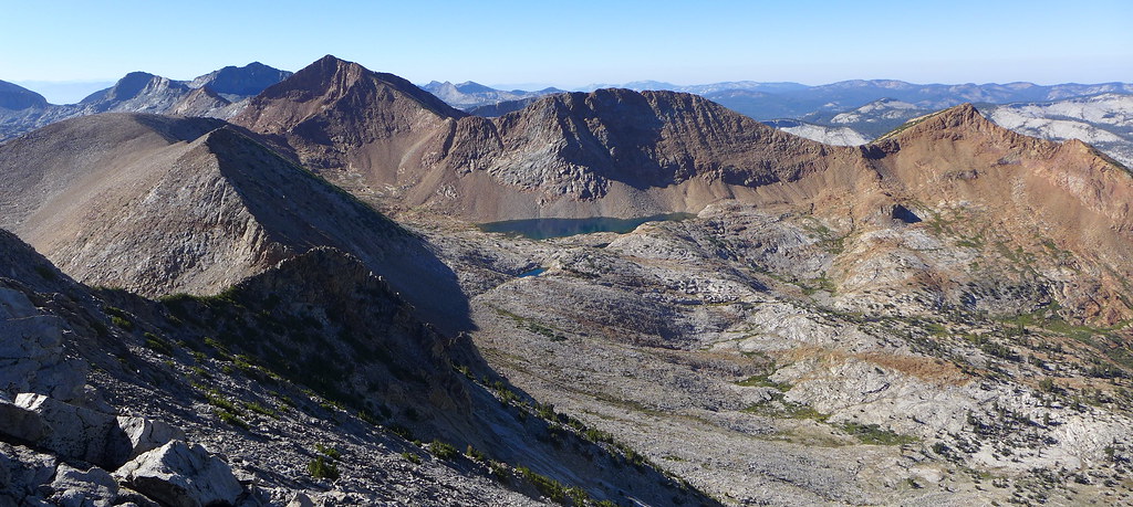
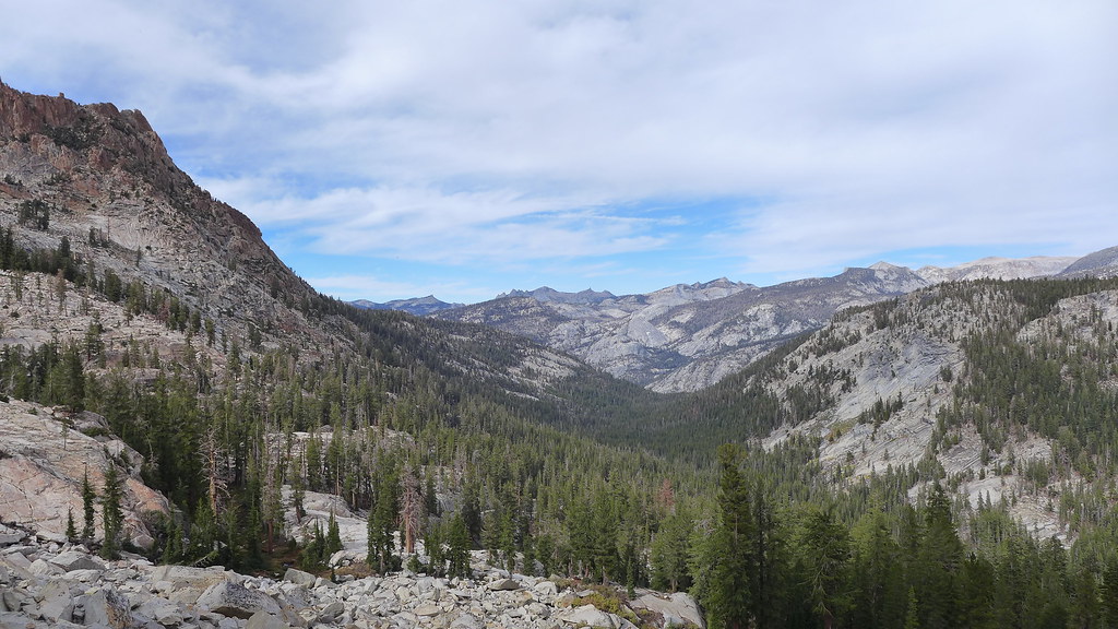
here's Gray Peak Fork Canyon from near Adair:
Anyzoo... have fun
I'll let you know if I go that-a-way ish before Aug
Aug should be fine w/r to snow and such this year... unless it dumps 100 ft of snow
from here until then... then still... might be ok.
I certainly welcomed the snow when did Red Peak as the rock in that area
is very sharp and moves a lot
Have fun
and may just since I need to touch this WL
https://mappingsupport.com/p/gmap4.php?ll=37.706062,-119.378901&z=14&t=t4
and we haven't boated Adair yet...
When visited Adair from Obelisk area we went around this
https://mappingsupport.com/p/gmap4.php?ll=37.693719,-119.405551&z=15&t=t4
we were going n to south (left to right in this pix)
in there...
here's Gray Peak Fork Canyon from near Adair:
Anyzoo... have fun
I'll let you know if I go that-a-way ish before Aug
Aug should be fine w/r to snow and such this year... unless it dumps 100 ft of snow
from here until then... then still... might be ok.
I certainly welcomed the snow when did Red Peak as the rock in that area
is very sharp and moves a lot
Have fun
|
Re: Grey peak ford to Merced lake? March 01, 2018 05:01PM | Registered: 6 years ago Posts: 31 |
Thanks for the info. My mind says it's doable I'm hoping my body agrees. Not sure if this is how to add link but but I'll give it a go
https://mappingsupport.com/p/gmap4.php?ll=37.692752,-119.408655&z=15&t=t4
https://mappingsupport.com/p/gmap4.php?ll=37.692752,-119.408655&z=15&t=t4
|
Re: Grey peak ford to Merced lake? March 01, 2018 05:12PM | Registered: 6 years ago Posts: 31 |
March 14, 2018 07:17AM | Moderator Registered: 14 years ago Posts: 7,421 |
You put the crosshairs right in the middle of big rocks.
We literally went down the gully... thus the two pix of
a) the gully from above
c) us in the gully
Please consider the route class 3. You'll probably have to use your hands plenty...
Winter has now arrived so timing/melt/ and all that will play into it much more than
if things had continued like they had been when you first asked.
Of course I love everything Yosemite. And the journey is the destination.
Not entirely sure why Obelisk Lake over ... say 10,425 or even Adair.
What do I know tho. Ran into a guy last year that lived in LA and simply wanted
to be in the trees.
If you can get to 10,425 in a day... you sure as heck can do Red Peak Pass loop
in 4 days.
Be safe
Have fun
Please Leave No Trace
Ok. I'll leave it at that.
|
Re: Grey peak ford to Merced lake? March 18, 2018 12:56PM | Registered: 6 years ago Posts: 31 |
Thank you all for the expert advise. I have about four months to work on my plan. My permit is for Aug 12 at MM TH and exiting on the 16th. 5 days 4 nights. I did extend my trip and added another day to make 10425. Depending on my condition upon arrival at 10425 I may revise the trip and day hike from here. That's what I love about YNP. There are so many options. That said I am definitely having some second thoughts about the loop. My biggest concern is that I am solo and this is too much off trial. I'm hoping to add someone but they have not committed yet and without another capable hiker the off-trail from 10425 to LYV is too risky. If anyone is up for an adventure let me know. I'm no climber and I realize that not many people enjoy or are capable of off trail adventures so I may have to change the master plan. Yosemite has so many incredible options it's always a great adventure.
|
Re: Grey peak ford to Merced lake? March 17, 2018 02:30PM | Registered: 12 years ago Posts: 190 |
There a lot to be said for doing the Red Peak Pass Loop from Mono Meadow. I saw almost no one until below Washburn Lake. Lower Ottoway Lake is beautiful.
Being an older woman I wandered around a far amount, and after coming down the Merced
River Canyon I ended up at the base of the Half Dome Cables,and took my time doing it.
Still I would think a loop out of Mono Meadow in August in 4 or 5 days would be doable and challenging.
Most people who get in trouble in the backcountry do it off trail. Also you don't want to put a friend in a position that might be more than he can manage.
For the curious, that trip report from July of 2013 is here. The first part is the Red Peak Pass Loop. I started and finished at Glacier Point, but Mono would work as well.
https://www.flickr.com/photos/lschaaf55/albums/72157634758821082/with/9345284655/
|
Re: Grey peak ford to Merced lake? March 28, 2018 12:00PM | Registered: 10 years ago Posts: 184 |
Agreed a great loop.
Suggest, if not wanting off-trail and solo -
Park car in the orchard lot and stay Valley BP ... early morning 8:00 bus - Curry to Mono Meadows TH - ($25)
Stay on Illilouette... maybe 8 miles in - due to bus/ late start. (BTW, after hitting the Illilouette about mile 7 - good campsite there but the next one, 1/2 mile up - better.)
Lower Ottoway - good fishing.
Amazing day - RPP - stay Red Devil...no fish but lots of frogs.
Follow Merced down - lots of options - but whatever you choose, always best when hiking back to your car.
Six nights, mostly downhill and maybe 50+ miles.
|
camping above LYV? March 31, 2018 05:03PM | Registered: 6 years ago Posts: 31 |
Any recommendations for a camping spot below echo valley and how far up from LYV are you required to go before you can camp? I will be hiking down the Merced and about 13 miles from LVY with the majority of it off trail. I'm not sure if I'll be able to make it all the way to LYV so I'm looking for suggestions for stopping short! It will be my last night and I'm hiking out to glacier point or the valley the next day. Anything around Brunnel cascades?
|
Re: Grey peak ford to Merced lake? March 16, 2019 09:10AM | Registered: 6 years ago Posts: 31 |
So Last August I didn't get to hike mono meadows/10425 due to fires. We opted to go earlier this year hoping to avoid the fires, but then the snow came. Our current permit is June 30 for glen aulin pass though. If the road from west side isn't open to Tuolumne on June 30, a backup plan would be mono meadows to Mt star king meadow then towards Mt Clark canyon then down Clark canyon to Merced. Any advice on the snow levels in previous years or best guess for June 30 this year, specifically the Mt star king meadows area from mono meadows TH. Any suggestions on route to star king meadow/ Mt Clark basin also appreciated. We also are very aware of the bridge issues or potential lack of one in pate valley which makes that a no go for glen aulin permit.
Clarifications- no plans to sumit Clark and if travel is too difficult due to the snow we would head to Merced river bridge via Clark canyon.
Based on the web cam at glacier point I'm thinking this plan is DOA. We will stay on trail to ottoway if we end up with this option. I think I got a little over optimistic when the park ranger said this area gets allot of direct sun. He must have been thinking of the illilouette trail. I know the trail down from mono meadow usually holds the snow
Edited 2 time(s). Last edit at 03/18/2019 04:30PM by Yosemrick.
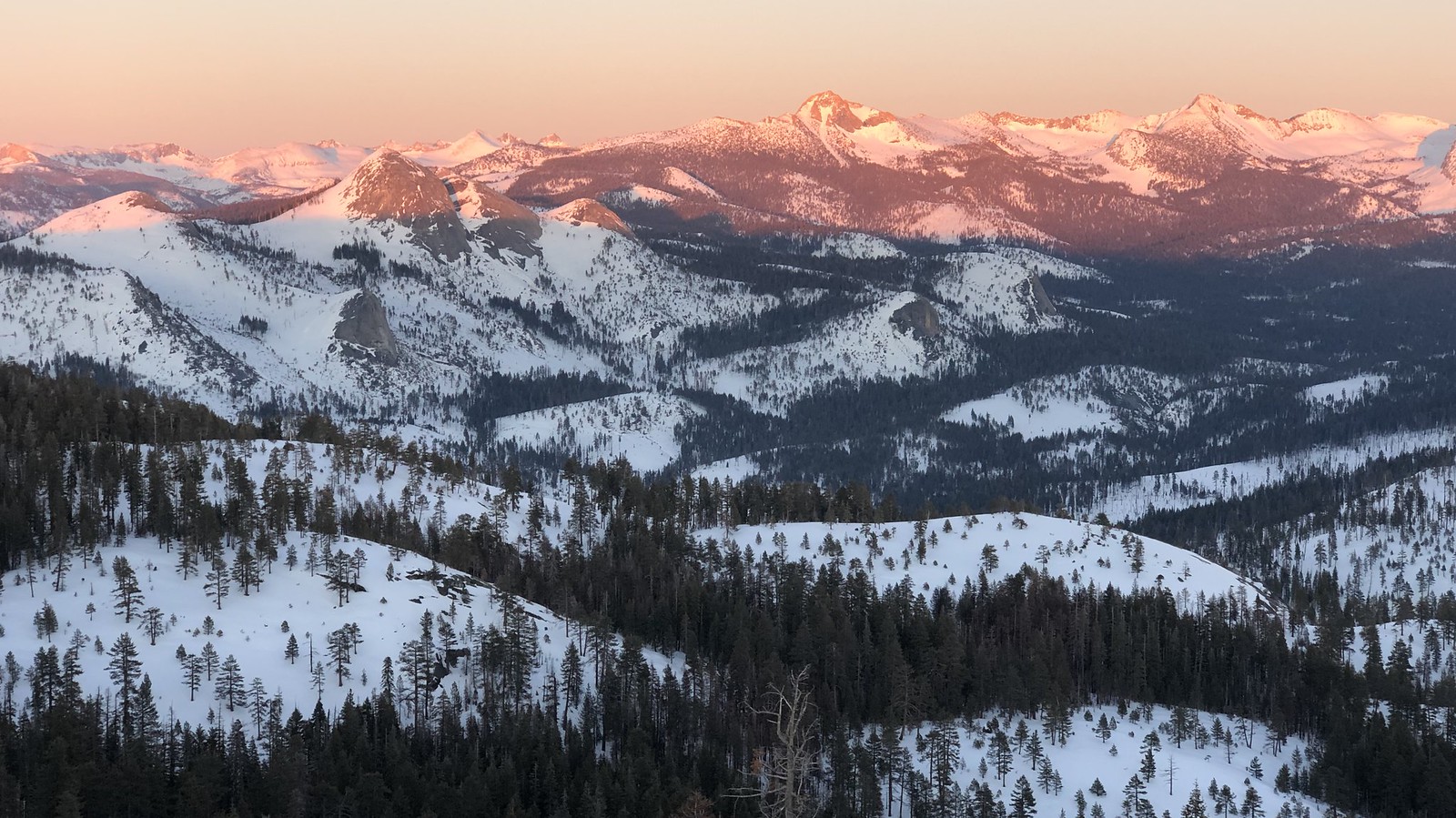
March 19, 2019 06:46AM | Moderator Registered: 14 years ago Posts: 7,421 |
Not sure what Clark Basin is. You want to go to Obelisk?
Anywho. Things looked like this last weekend:
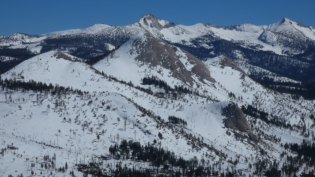
There's gonna be a whole lotta snow up high well into July.
Probably more than in 2010, 2011, and 2017.
The ranger was talking Ill basin. It clears out much earlier. But... I would hope would have
mentioned the small creeks you have to cross … may be death defying this year in June.
Anywho. If haven't seen here's Tuolumne and such area in 2017 in a bunch of pix:
https://yosemitenews.info/forum/read.php?17,89825,89825#msg-89825
Have fun
Anywho. Things looked like this last weekend:
There's gonna be a whole lotta snow up high well into July.
Probably more than in 2010, 2011, and 2017.
The ranger was talking Ill basin. It clears out much earlier. But... I would hope would have
mentioned the small creeks you have to cross … may be death defying this year in June.
Anywho. If haven't seen here's Tuolumne and such area in 2017 in a bunch of pix:
https://yosemitenews.info/forum/read.php?17,89825,89825#msg-89825
Have fun
|
Re: Grey peak ford to Merced lake? March 20, 2019 06:07PM | Registered: 6 years ago Posts: 31 |
Nice photo. It looks like it's taken from pretty high up? I can't figure out where it's taken from. Buta my Clark "basin" would be starting point of the Clark ford or the awesome bowl below the NW arete. No obelisk. I figured we'd be lucky to make it to Clark "basin"... My hiking party didn't like my off trail plans.  I have a flight booked so I'm committed to the June 30 hike in date. If you have any suggestions I'd welcome your ideas. 4 days 3 nights. I love the Sierra. I can't think of any hikes I've been on that I didn't totally enjoy. We have permit for GA pass through but It doesn't sound very promising that 120 will be open by June 30. Will 120 be open to traffic even if it's not plowed all the way through? i.e. Open to ten lakes? For me planning the route is half the fun. I'll just have to wait it out and see. Lots of snow in Minnesota this year too. Not 50 ft like Mammouth but I still have 1-2 ft in my yard with 3-4 ft piles around the driveway.
So your July 2017 trip.. Looks like you covered allot of ground. What do you recommend for the footsies. Snow boots or could you use high tops like the Salomon GTX. Seems like you would get wet feets with all that ❄️
Edited 2 time(s). Last edit at 03/21/2019 05:53PM by Yosemrick.
I have a flight booked so I'm committed to the June 30 hike in date. If you have any suggestions I'd welcome your ideas. 4 days 3 nights. I love the Sierra. I can't think of any hikes I've been on that I didn't totally enjoy. We have permit for GA pass through but It doesn't sound very promising that 120 will be open by June 30. Will 120 be open to traffic even if it's not plowed all the way through? i.e. Open to ten lakes? For me planning the route is half the fun. I'll just have to wait it out and see. Lots of snow in Minnesota this year too. Not 50 ft like Mammouth but I still have 1-2 ft in my yard with 3-4 ft piles around the driveway.So your July 2017 trip.. Looks like you covered allot of ground. What do you recommend for the footsies. Snow boots or could you use high tops like the Salomon GTX. Seems like you would get wet feets with all that ❄️
Edited 2 time(s). Last edit at 03/21/2019 05:53PM by Yosemrick.
March 24, 2019 08:01AM | Moderator Registered: 14 years ago Posts: 7,421 |
I use Salomon GTX of some sort. Pretty much goretex year round... for either dirt into shoes... or water into shoes.
yeah they don't last forever, etc. etc. but …
I guess I'd go with a porous shoe if had to get wet a lot so can dry out …
but anywho…
I guess I should link to this for that guy going up Snow Creek on the 4th...
https://yosemitenews.info/forum/read.php?3,39233,39233#msg-39233
You can see from this set in here... I used low tops. I mainly use high now.
Just feels like more support.
Have fun. There's been some great reports from the TM rangers. With some astounding pix.
Personally, I pretty much can't get enough.
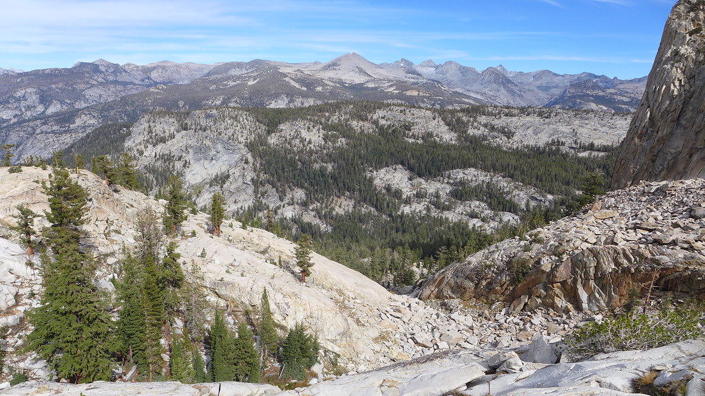
More or less... it's Clark View.
Wanted to show u how much snow... if you look for latest TM Ranger report... you get a good idea
There more than 5ft. along GP Road...
yeah they don't last forever, etc. etc. but …
I guess I'd go with a porous shoe if had to get wet a lot so can dry out …
but anywho…
I guess I should link to this for that guy going up Snow Creek on the 4th...
https://yosemitenews.info/forum/read.php?3,39233,39233#msg-39233
You can see from this set in here... I used low tops. I mainly use high now.
Just feels like more support.
Have fun. There's been some great reports from the TM rangers. With some astounding pix.
Personally, I pretty much can't get enough.
More or less... it's Clark View.
Wanted to show u how much snow... if you look for latest TM Ranger report... you get a good idea
There more than 5ft. along GP Road...
|
Re: Grey peak ford to Merced lake? April 02, 2018 12:08PM | Registered: 10 years ago Posts: 184 |
Going down, after crossing over the Merced footbridge, just below Echo Valley - (now you are temporarily south of the river) - not much good camping thru the Bunnell Cascade area until down to the next 2 bridges below...(past the 14 switchbacks). Here, some possibilities exist south of the river, just before the first bridge. Once crossed to the north-side of the Merced River again (second bridge), there are a few great spots right there ...just above the trail - north...follow the small stream up ~ 100 yards.
But personally, have always preferred to spend my last hiking night at the Morraine Dome Waterslide area when coming down, but have not stayed there since the last fire..
BTW, From Morraine Dome, it is 2 trail miles down to the LYV, (a zoo camp)... and there is posted "no camping" during this 2-mile interval.
Sorry, only registered users may post in this forum.

