
This is a long ridge, or rather a series of knobs, running from White Wolf to El Capitan. It stays cool when the Valley is hot. The views are good. But the nicest thing about this hike is that you can do it as a roughly 9 mile cross-country bushwhack with absolutely no bush.
It starts at about 8300 foot elevation. It climbs about a thousand feet to the local high point, then heads south down the ridge. After about a thousand foot descent, you go back up for 700 feet, then descend to about 7700 feet to the El Cap Trail near Ribbon Meadow. Of course, once you are on the trail, you still have to get home. There are four ways home from here: You can take the trail east over El Cap and down the Falls Trail. Or you can descend west to the junction with the Old Big Oak Flat Road. From that point, you can go to Tamarack Flat Campground, the Foresta Trailhead, or to the Valley by the abandoned old road. I've done them all. I think that the eastern route is the most tiring of the bunch, but it does get you directly back to the Lodge, where guys who drove your car back are probably comatose in the bar.
This hike is all off-trail from knob to knob, so the actual vertical up and down is more than you might expect from the above description.
The high point at the beginning of the hike is close enough to White Wolf and to Yosemite Creek Campground that you might see someone there, though I never have. I have seen footprints, though. South of there I've never seen any signs of anyone's passing: No footprints, no litter, nothing. It is not untracked wilderness, though. The first part is along the county line, which is also the drainage divide between the Merced and Tuolumne Rivers. In the bad old days, grazing permits were issued for this sort of terrain. The permit boundaries must have aligned with the county borders, because you will see occasion bits of barbed wire on the ground along this section.
A higher resolution version:
http://docs.google.com/leaf?id=0B9ZDeFswongBYTcyN2QxMDUtMTc3ZS00ZWI0LWIzMzMtOTIyZDZmOWQ5ZjYz&hl=en
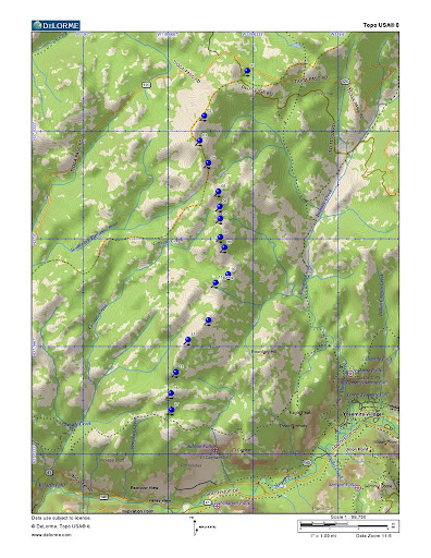
Route: You could start the hike at White Wolf, but the best place to start is on the campground entrance road (Old Tioga Pass Road) near the county line. See waypoint 1. From here, hike southwest uphill to a saddle on the ridge, and then follow south along the west edge of the ridge. Good views to the west because of a sharp dropoff on your right.
From the summit, follow the waypoints as shown. You will pass a couple of knobbly things on the ridge in the vicinity of waypoints 7 and 8. Use your route finding skills to decide how to bypass the minor obstacles here on the right while using minimum effort.
Unfortunately, the only day I was up there with a digital camera, there were forest fires in the Sierra:
http://lh5.ggpht.com/_t_hAs6ZD8gk/TCv-yv6DaCI/AAAAAAAAADo/l0EVOrl7qEo/s512/Hazy%
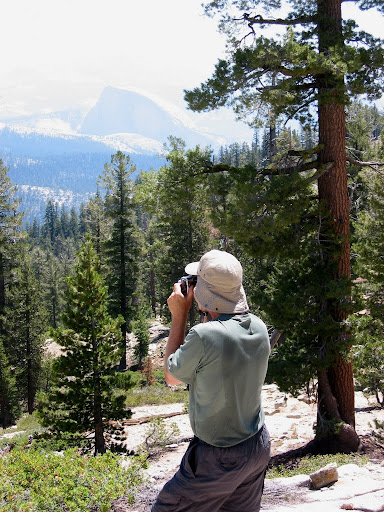
But this photo shows the sort of easy going underfoot that you will find.
Waypoints 9, 10, and 11 require more attention. If you go straight from 9 to 11, you will cross a bog. If you stay too high on the left side and pass east of waypoint 10, you will get into some broken granite blocks that will slow you down. Keep your eyes open, and you'll have no problem.
This is a dry hike. But there is a fairly reliable spring at waypoint 11. There are also some flowing seeps just east of there. If you need water get it here. Proceeding beyond that point, just walk up the slickrock to waypoint 12 and continue down a grand, open, grassy ridge to the El Cap Trail. There is nothing on this hike that requires precise route-finding, so long as you don't get started down the wrong ridge somewhere. Even if you do that, it should be all right. I've tried three variations to the west of the finish, heading more directly towards Tamarack Creek Campground and/or Tioga Pass Road. I can't recommend any of them right now, since they all ended in post-fire thickets, but none presented any serious barrier to passage. From the aerial photos, I'm confident that a good route that is more direct to the campground exists, but I haven't hiked one yet. There is some very interesting terrain in there: outcrops, boulder fields, open ridges and a little lake with sceaming peepers. Lots of interesting little route finding problems, with nothing that's really serious.
I'm also interested in finishing the hike by going down the gully between this route and Boundary Hill to catch Yosemite Creek Trail, but I can't recommend it until I've done it. Try my preferred route first. You'll like it.
Waypoints:
37.850583,-119.637654,01
37.836639,-119.654460,02
37.828939,-119.656229,03
37.822060,-119.652910,04
37.813192,-119.648937,05
37.808529,-119.648380,06
37.804849,-119.648269,07
37.799069,-119.648189,08
37.795870,-119.646570,09
37.787550,-119.645139,10
37.784999,-119.649999,11spring
37.773379,-119.652880,12
37.767380,-119.660840,13
37.757319,-119.665539,15
37.750790,-119.667520,16
37.745640,-119.667319,17


