
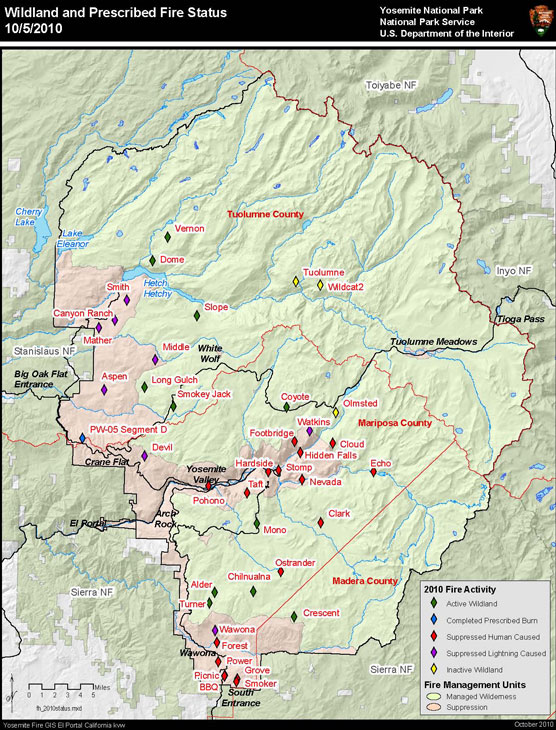
Fires the First Weekend in October: At least 15 fires started due to lightning-based storms on Oct. 1-4. Fire managers identified eight fires in Tuolumne County, six in Mariposa County and, one in Madera County.
* Oct. 1 Fires: Two fires were discovered in the park: the Long Gulch Fire near Aspen Valley, and the Smokey Jack Fire east of Highway 120 and north of where the South Fork of the Tuolumne River crosses Highway 120.
* Oct. 2 Fire: One fire discovered in the park: the Coyote Fire, northeast of the Porcupine Flat campground near "coyote rocks."
* Oct. 3 Fires: Eight fires discovered in the park: A visitor reported the Mono Fire, just off the Glacier Point Road north of the Mono Meadow Trailhead. Other fires include the Chilnualna Fire, at the top of the Chilnualna Falls trail; the Crescent Fire near Crescent Lake off of Chilnualna Creek; the Turner Fire on Turner Ridge; the Middle Fire near Bald Mountain; the Smith Fire near Smith Peak; Dome Fire is near Hetch Hetchy Dome; and Alder Fire is near Alder Creek.
* Oct. 4 Fires: Four fires discovered in the park: Wawona Fire, the south face of Turner Ridge and is visible from Wawona; Canyon Ranch Fire on the Hetch Hetchy Road; Mather Fire, east of the Hetch Hetchy entrance and south of the Hetch Hetchy Road; and Aspen Fire, two miles due west of Aspen Valley and southeast of Ackerson Meadow.
Suppression Zone: The Middle, Aspen, Canyon Ranch, Smith, and Mather fires occur with the park's suppression zone and will be extinguished.
Wildland Fire Zone: The 10 other October fires are in the wildland fire zone, where fires can be managed for multiple objectives.
Note: Yosemite fire management has not flown a reconnaissance mission since Oct. 3, so there may be other fires burning in the park. However, given the wet weather and the duration of the weather system, this could be a season-ending event. Fire management will evaluate all fires in the wildland fire zone when low pressure moves out of the region.
Summer's Earlier Fires: The Slope and Vernon fires have been burning since mid-summer. Both of these fires have aided significantly in restoring forest health by the return of fire to the landscape. The fires have been managed and monitored with little intervention by firefighters, allowing the fires to move in natural directions and filling key pieces of the fire mosaic. Although it has been very warm, cooler night time temperatures and shorter days have slowed each fire's growth due to overnight recovery of humidities. Follow specifics on individual fires within Yosemite:
Slope Fire (37 54.572 x 119 40.924; 6,900-foot elevation, Tuolumne Co): Located approximately one mile northwest of Harden Lake, this fire covers 1,711 acres. The fire grew 123 acres (+/- error of helicopter flight line) since Sept. 25. Fire activity has decreased but continues to spread slowly as a surface fire with occasional single tree torching. Only 10 to 20 percent of the southern perimeter is active, and the north end (next to Hetch Hetchy Reservoir) and interior is mostly cold. The fire is burning some brush but largely the downed logs and snags and fine fuels on the ground. On the morning of Sept. 29, fire crews held the southwest corner of the fire at the Harden Lake Road to reduce smoke affecting residents of Tuolumne County. The holding actions were minimal due to the fireline intensity and should reduce nuisance complaints about the fire. Fire crews have been removed due to lightning dangers.
Vernon Lake with mountains and smoke-filled skyline
The Vernon Fire, with Vernon Lake, has burned more than 400 acres by early September.
Vernon Fire (37 59.813 x 119 43.618; approximately 7000-foot elevation, Tuolumne Co.): This 909-acre fire, located approximately three miles north of the Hetch Hetchy Reservoir and one half-mile south of Lake Vernon, is the result of the thunderstorm activity on Aug. 8 with a single tree being hit by the lightning. The fire grew 158 acres (+/- error of helicopter flight line) since Sept. 25. It is creeping through fine fuels and downed trees and snags and occasionally torching single trees. The most active portion of the fire is the southern end. The Incident Commander is Parker Bevington. Fire crews have been removed due to lightning danger.
Trails Open: All trails through the Slope and Vernon wilderness fires will be open. These include trails between White Wolf, Harden Lake and Pate Valley through the Slope fire and the Tiltill Valley trail through the Vernon fire. Be aware of fire weakened trees and snags and burning logs, litter, and duff that are still present in fire areas. The trail tread may be compromised in places as well. Please use caution when travelling through burned areas.Cooperators for the Vernon and Slope fires include the San Francisco Water Quality and Public Utilities Commission at Hetch Hetchy, and the Tuolumne County Air Pollution Control District.
Other Park Fires: The Tuolumne and Wildcat 2 fires are inactive and in patrol status
http://www.nps.gov/yose/parkmgmt/current_fire.htm
Edited 1 time(s). Last edit at 10/06/2010 05:44PM by eeek.

