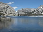
On our recent trip to Conness Lakes when we were photographing from the south side of the middle lake, I started thinking about going to the upper lake. I don't know if this is something that is within our capabilities. I have not been able to find out much about the route up there from the middle lake. Is there anyone here who can describe how you get up there? Maybe you could use this image as a reference:
http://panoramas.aa6g.org/ConnessLakes/ConnessMiddleLake-2.html
We did see two hikers walking along the north shore and it looked easy, even at one point that looked steep from our viewpoint. They were headed down. I also found them in a photo I took a bit earlier in the rocky granite area above and to the right of the waterfall. I have no idea how they got down from there to the lake.
Our capabilities are hiking with a hint of class 2. I don't want to do talus climbing.
I also wonder what is the best way to get from the lower lake to north side of the middle lake. We didn't have time to wait to see how the hikers did it.
I'd appreciate any advice.
Edited 1 time(s). Last edit at 08/10/2012 04:15PM by Calaveras.
Middle to Upper Conness Lake Route
All posts are those of the individual authors and the owner
of this site does not endorse them. Content should be considered opinion
and not fact until verified independently.
August 10, 2012 04:14PM | Registered: 12 years ago Posts: 229 |
|
Re: Middle to Upper Conness Lake Route August 10, 2012 06:27PM | Registered: 13 years ago Posts: 693 |
I went up North Peak a couple of weeks ago. Cross the lower lake near the middle of the lake. Cross one outlet (which goes to what I consider the "middle" lakes) then head up the left side of the outlet of the next lake. Cross over the outlet creek (N) on rocks before reaching the lake in your photo. Climb a bit above the lake...a use trail is evident. Then you must make a decision how to climb further above this lake...there are multiple use trails to choose from. It is a slog wherever you choose. (Easier to pick your way down on the return trip though.) You climb above the striped granite in your photo, then traverse...there are paths through the trees or above the trees. You eventually want to get above the trees and will have fairly level travel from there. I did see a couple of guys reach the lake from above the falls in your photo.
Also if you are not using the boat shuttle, stay on the south side of Greenstone Lake for quicker access. With the lower water, you can cross this lake's inlet, then access the trail into the Hall study area.
Also if you are not using the boat shuttle, stay on the south side of Greenstone Lake for quicker access. With the lower water, you can cross this lake's inlet, then access the trail into the Hall study area.
August 11, 2012 10:22AM | Registered: 12 years ago Posts: 229 |
Thanks for your description. I'm having a bit of a hard time understanding which lakes and creeks you're referencing. I think you're calling the the green lake to the south the "middle" lake. Maybe it makes the most sense to call the three largest lakes the lower, middle and upper. I've seen some references to the tarn below Conness glacier as the upper lake. When you say "head up the left side of the outlet of the next lake" I think you're referring to the creek between the two turquoise colored lakes (lower and upper) which are separated by a ridge. We have not tried to do that yet. I think the hikers we saw stayed along the upper lake northern shore and went up below the striped granite and then through the trees and then crisscrossed the rocky slope to get up to the tarn.
It wouldn't surprise me if there was a use trail all the way up but finding it or finding someone who's hiked it is the hard part.
It wouldn't surprise me if there was a use trail all the way up but finding it or finding someone who's hiked it is the hard part.
Sorry, only registered users may post in this forum.


