http://yosemitenews.info/forum/read.php?3,48350
Anyway, I was up there this week with three grade-school-age grandkids. Not a good trip for doing rough bushwhacking, but the kids were more than happy with Oh My Gosh Point (on the Yosemite Falls Trail), and with the long loop trail around Mirror Lake. And they did the wonderful kids' hike from Tunnel View up to (new) Inspiration Point, then down the abandoned old road along the top of the cliff above the tunnel and onward to the base of Bridalveil Falls.
But, of course, I couldn't avoid poking into a bit of history. There is a new book at our library, called "The Inventor and the Tycoon: A Gilded Age Murder and the Birth of Moving Pictures", about Leland Stanford and Eadweard Muybridge. Muybridge was an interesting character, crackpot, photographer, and murderer. He killed his wife's lover, and got off partly on an argument of insanity, the evidence for which was partly based on photos of him on the cliffs of Yosemite.
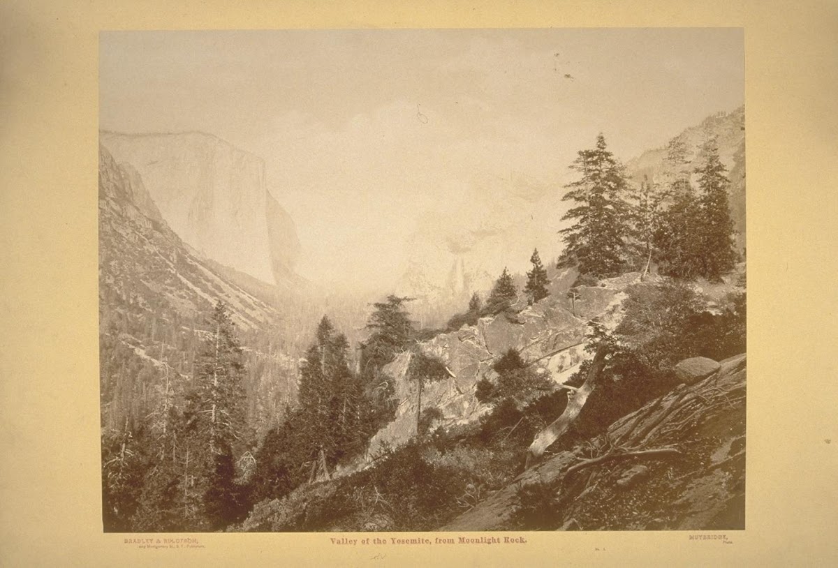
He was also the first to take a large plate camera to the valley. He got some great photos. In 1872, he took a photo from Moonlight Rock that was widely circulated:
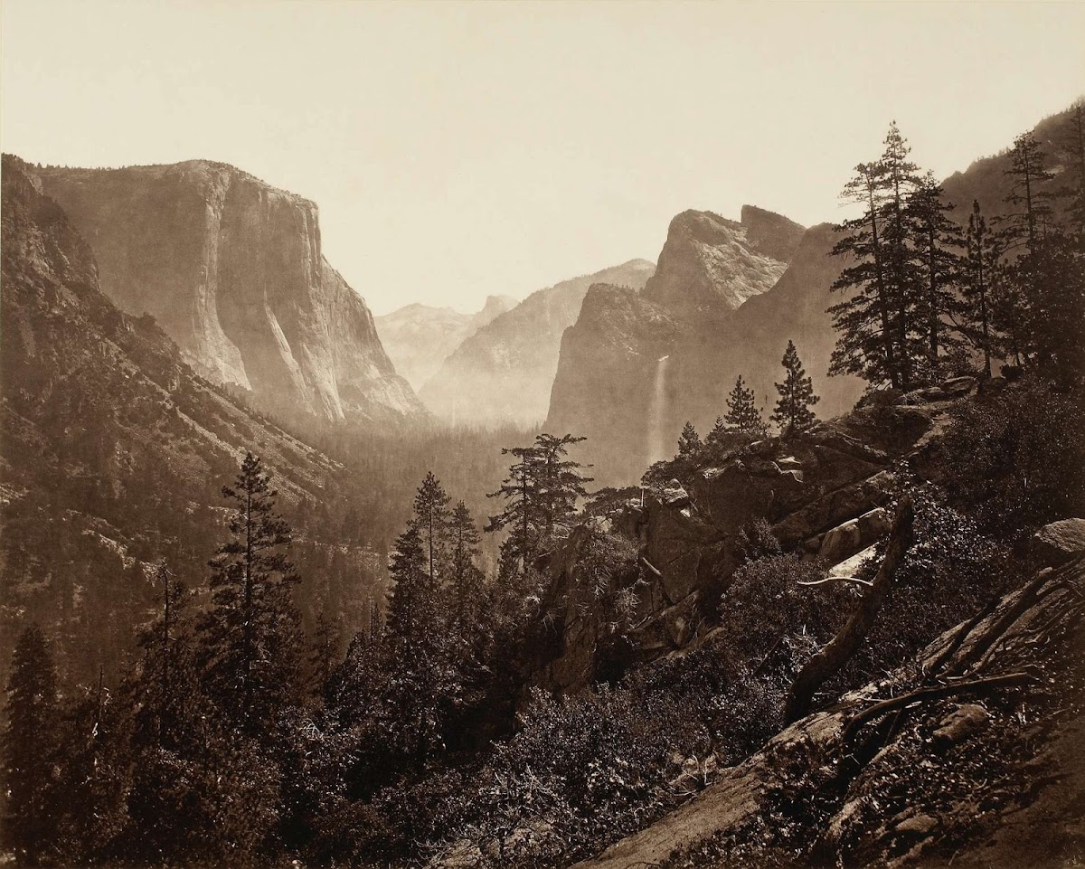
Unfortunately, photographic emulsions of the time were mostly blue-sensitive, which accentuates the haze. Thus, Sentinel Rock is essentially invisible in the above photo, but it is actually in the scene...
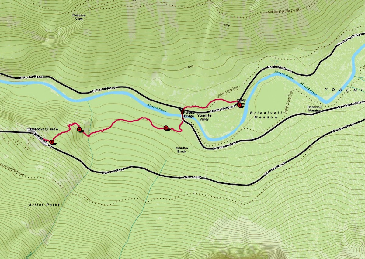
The view looks familiar, right? Moonlight Rock must be somewhere near Inspiration Point. It also must be near the Mariposa Trail. The reason for this is in the timing. There were no roads into the valley in 1872. Two years later, you would have seen the Old Big Oak Flat Road being built across that talus pile over towards El Capitan. A year after that, the wagon road from Wawona to the valley was completed, and you could have taken a photo from New Inspiration Point. But in 1872, there was only the mule trail that came down through Meadow Brook meadow to the valley rim, then down past Old Inspiration Point and all those other named points mentioned in that first link above.
Large plate photography was a big deal in those days, because the cameras were huge. You had to make the photographic emulsion on the spot and coat the glass plate with it in a light-proof tent immediately before making the exposure. So you needed mules, even more than Hill needed them for his easel and canvas. Wherever Moonlight Rock is, it must be next to the old Mariposa Trail.
One way that these places got named was by the muleteers, who were the tour guides of the day. It was important that the tourists thought that you took them to all the best places, so the guides named everything along the route. Hence, today's Inspiration Point is where it is because the previous one was on the Mariposa mule trail, not on the Wawona Road. When the road was built, it didn't go by the original Inspiration Point, so they named a new one where the road touched the old trail. By that reasoning, the name should have been moved again when the newest road and tunnel was built in 1933. But too many people had now been to the previous Inspiration Point, so they had to name the new place "Discovery View", i.e. "Tunnel View and parking lot". Artist Point is another example. There is no point there, at least not along the road where the name is applied....
Anyway, Moonlight Rock must be some lookout point in that vicinity, accessible before either road was built.
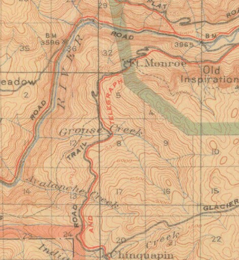
If you look at the old maps, they consistently show the Mariposa Trail coming down the ridge to New Inspiration Point, then continuing northeast down the hill to the bank of the Merced near the Pohono Bridge. The Old Wawona Road has some switchbacks below Inspiration Point, then crosses the old trail and descends at a uniform grade straight to the Bridalveil parking lot. The new Wawona Road and tunnel do the same thing, but at a lower elevation and a less steep grade. There was a period when the foot trail was bent west to hit Fort Monroe, when it was the entry station to the park, but after that ceased to be true it reverted to the older route, now called the Pohono Trail.
In 1893, the USGS issued a version of the 1883 Wheeler map with the roads highlighted in red, as an attachment for some Yosemite legislation:

In that map, courtesy of the Rumsey collection, the Mariposa Trail is clearly seen to touch the road at (new) Inspiration Point, then continue down to the valley at a steeper pitch than the road. The trail, which was based on the old Indian route, would not want to cross Artist Creek or Meadow Brook while traversing a steep hillside. It would just go directly down the hill. The trail itself was famously steep, according to writings of the tourists on muleback. The map above predates the period when the trail was re-routed over to Fort Monroe and down the road to the valley.
Here is a 1910 map, courtesy of Chick-on, showing that later route. Coming down the trail (now called the Pohono Trail) you were expected to hike on the road from Fort Monroe down to the valley, if you didn't have a horse to carry you.
After the old Wawona Road and Fort Monroe were both abandoned, the foot trail went back to the original Mariposa alignment, i.e., directly to New Inspiration Point, then shortcutting the Wawona Road switchbacks until you hit the old road again. There you had the choice, as you do today, to continue down to Discovery View or follow the old road acting as a trail to the base of Bridalveil Falls. Here is a map from the Hill's Point thread:
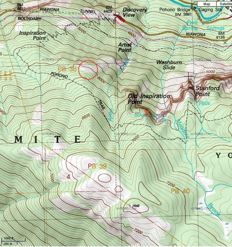
The circle and X are only relevant to that previous thread.
So the first question is, can we locate Moonlight Rock? How closely does the current trail to Inspiration Point align with the original Mariposa Trail?
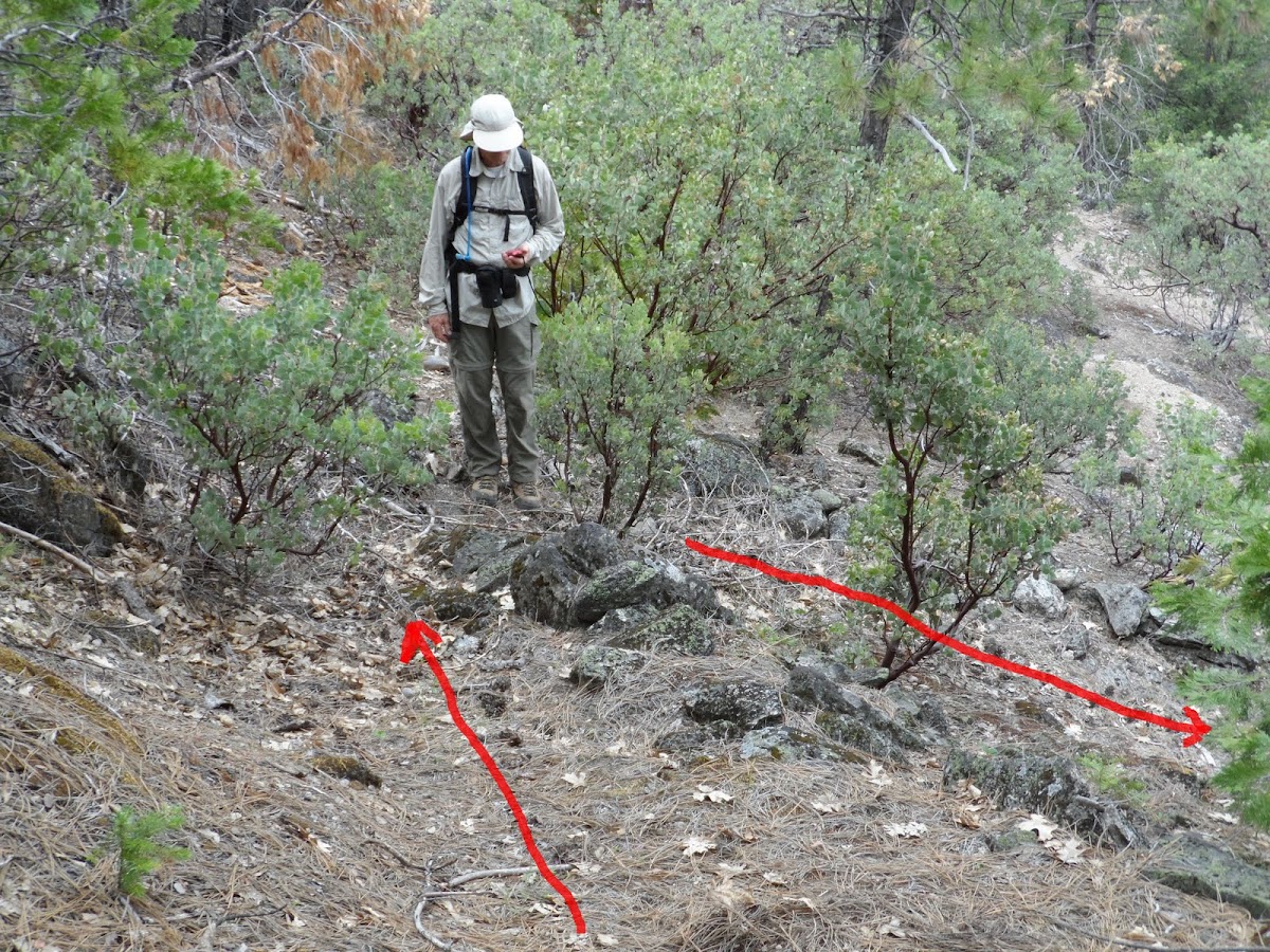
Quite closely, as it turns out. We drove to Discovery View, grandkids and all, and whipped out the Muybridge photo. Stood at the trail head at the east end of the parking lot. Sighted the alignment of Lower Cathedral Rock, Sentinel Rock, Half Dome, etc. Humpf. We were only fifty feet from our destination. They have built their parking lot and trail head at the base of Moonlight Rock, and right athwart the original Mariposa Trail!

A few steps up the trail, and you can see the same little escarpment that Muybridge did, and the same panorama (except for some trees blocking the view) if you step out onto the wet rock. Of course, the view from the parking lot is virtually the same. A photo that took Muybridge half a day to produce in 1872 now takes ten seconds.

I expect that it was called "Moonlight Rock" because it glistens in the sun when wet with moisture, which is most of the time in the Spring:

So much for that bushwhack. We went on with the planned hike to Inspiration Point, and down the old road to the base of Bridalveil Falls.
But this all leaves us with another bit of untrodden abandoned trail.....the Mariposa Trail from Discovery View and Moonlight Rock down to the Pohono Bridge. There aren't many route choices, because it is all cliffs to the west and somewhat steeper to the east. If you look at the topo map above, you'll see where to look for the old trail. If Chick-on doesn't get there first, we'll check it out some day when we only have time for a short hike....
Edited 2 time(s). Last edit at 05/04/2013 09:08PM by wherever.