Last year we discovered the beauty of Cherry Creek Canyon (before the Rim Fire). We benefitted from information found here (lurking). We'd like to return, and want to improve on our previous adventure, hence this first post. Despite some challenges, it remains one of the most beautiful hikes we've ever experienced.
We entered at Shingle Springs, down the brush to the creek, eventually to Lord Meadow, up out of the canyon and back on Kibbie Ridge Trail. We had planned to do much more, avoiding most of KRT, but we made much less progress each day than expected and had to take the express route back.
We had two major setbacks. First, between the Chockstone Route (we were able to ford the creek at the beach and avoid the Chockstone) and Camp Flintstone, we struggled to find a way around the waterfall. Timing was remarkable such that we met a group of three seasoned hikers that claimed to visit each year for over 20 years, having seen bears drown in the creek, etc. They suggested a way around the first fall, crossing to the west of the creek, up and around the back of a dome. We decided to continue as we had originally planned, expecting to find a route beginning at the fall, on the east. We searched for a route away from the creek, but each time came up short. We then tried to find a route close to the creek, but the slope of the granite was too step to give purchase underfoot. Eventually we decided to look for the route on the west side. We crossed the creek and scaled the dome readily, but spent hours trying to find the way around the back, or over the top, back to the creek. Finally, we ended up backtracking to the creek, not far above where we originally crossed, but luckily above the falls. That was the better part of an afternoon. We are still not sure how we missed the route on the east side, and wonder if there really is any way around the back/top of the dome that we had attempted on the west side.
The second challenge was of course circumnavigating the Cherry Bomb. We set out from Camp Flintstone fully energized, and found a route up to the granite ramp to climb out and around the next falls. It was after this first success that we again became stuck. I've searched here and everywhere I can think of but have unfortunately not found what I'm looking for. Chick-on provided a GPS track in some post somewhere, and we tried to follow that at this point. We tried to get up to the high bench above us, thinking that there was a ledge traversing the steep face that would reach the top. I ended up abandoning that route at a block about 20' high with a sheer drop down on the left and a sheer wall on the right. Backtracking, I found a wide, steep granite ramp (with a mylar balloon apparently marking something) but again, the ramp was so steep that without a rope, and without any handholds, friction was not enough to maintain forward progress - and I found no way around this ramp. Ultimately, we ended up backtracking quite a bit, descending half way back to the creek, then moving up along a crack (dry creek bed) with boulder fill, finally reaching open granite, before our final descent back to the creek (down a steep, rugged and brush-covered slope, to a small meadow, and finally past the 3' diameter round erratic perched on polished granite shortly before reaching the creek.
My hope is that we can learn from our mistakes, with the help of others that have found a better way.
Edited 1 time(s). Last edit at 03/29/2014 08:43AM by ags.

The Moon is Waning Gibbous (97% of Full)
Cherry Creek Route Finding
All posts are those of the individual authors and the owner
of this site does not endorse them. Content should be considered opinion
and not fact until verified independently.
|
Cherry Creek Route Finding March 26, 2014 04:59PM | Registered: 10 years ago Posts: 322 |
|
Re: Cherry Creek Route Finding March 26, 2014 06:10PM | Registered: 11 years ago Posts: 196 |
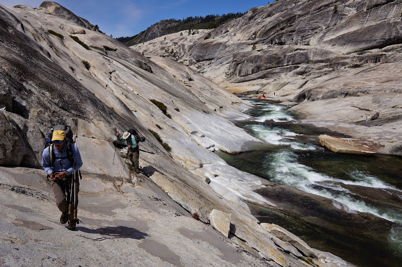
It's been a few years since I've been down it, so my memories of the route finding are not fresh. Got any pics of the areas you are talking about? We did it at the peak of the snowmelt in 2011 (a big snow year) and crossing the creek was not an option. We stayed on the southeast side the whole time with no problems. But there is a lot of micro route finding required, and being comfortable on polished granite is a prerequisite.
|
Re: Cherry Creek Route Finding March 26, 2014 08:39PM | Registered: 10 years ago Posts: 322 |
|
Re: Cherry Creek Route Finding March 27, 2014 12:23PM | Registered: 13 years ago Posts: 864 |
This waterfall?
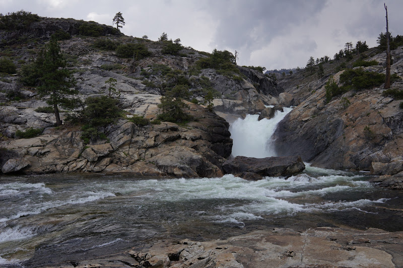
You climb up to the right of the falls (facing upstream--basically above and behind the dead tree in the upper right of this picture), working back towards the creek along brushy granite ledges until you find a nice ledge, maybe 100' above the water, that heads up the gorge above the falls. Follow this ledge until it crosses a broad gully, which you climb another 100-200' or so until things level out in an open juniper area, which you can see in the picture above and to the right of the falls. There is a faint trail in this area, but you don't need to find it--it's open once things level out. Finding this route while heading downstream is tricky only because you can't see the ledge until you go down the (now very steep-looking) gully a bit, so it's a bit of a "blind" approach.
From Flintstone, there is a seasonal creek that enters the canyon from the east/right. Keep between it and Cherry--basically go over the dome--then drop a bit to open granite and meadows, where there are a few seasonal ponds indicated on the map. Keeping this elevation while heading NE-ish, you eventually reach a "pinch" area--cliffs to the right, a gully to the left. Thrash through some burnt brush towards the right for 50-100', then drop maybe 50' into the gully. Because this is a choke point on the route, there is usually ample evidence of use: broken branches, footprints, rock piles at the bottom of the gully, etc. It sounds like you found this gully, but for completeness: head up the gully until an open flat area, climb a few feet out of here then drop (steeply in a few places) towards the north into a second, marshy gully. Climb out of it, then drop to Cherry, somewhere around here:
From here, follow the creek to Lord Meadow :-)
Edited 1 time(s). Last edit at 03/29/2014 09:13AM by basilbop.
|
Re: Cherry Creek Route Finding March 29, 2014 08:39AM | Registered: 10 years ago Posts: 322 |
Wow, I'm not sure what happened. My post is getting long so I'll separate the "first fall" issue from the "cherry bomb" issue.
"First Fall": Yes, that's the fall. I spent an hour first trying to find a way up the steep slope downstream of the falls and further away from the creek, thinking I could get to the top of the granite that way. I could not. I don't specifically recognize the dead tree you point out, but I do recognize that area. I spent another hour trying to find a way up there. I was looking for an "around and over" route - meaning departing dramatically from the stream - or an "alongside the stream" route. I made progress up the slope, perpendicular to the stream, but was never able to get up to a flat(er) spot. I was stopped by very thick growth and/or walls at every attempt. Trying to follow the creek, the granite slope seemed too steep to be a reasonable route. Perhaps that was just my judgment; assessing the risk, I saw significant exposure - no possible handholds, cracks, ledges to arrest a fall; a certain drop into the creek, potentially striking large rocks along the way and/or in the water; no immediate exit from the creek possible and a swift current that would take me down and over the fall - and I was unable to get enough traction on the granite to prevent slipping down to the creek. The only thing I can think of is that I shot either too high (away from the creek) or too low (alongside the creek) but the route you describe is in between. Still, I really did spend an hour looking and don't know how I could have missed it - except humans often don't see things that are in front of them but not what or where the expect them to be. Perhaps knowledge of the ledge you mention would have helped. I'm really stymied by this, particularly given the amount of time I spend searching here. It was my first time in CCC, but I am experienced in off-trail hiking and route finding. Just to be clear, when you speak of the open area with juniper, you do mean to the left of the falls in the picture (there is a lone tree on the horizon in that general area) and not to the left, correct? I may have been heading too far to the right (in the picture).
Since I could not find a way around on the S-E side of the creek, I ended up crossing the creek below the falls and heading up the dome on the other side. As I stated before, other hikers claiming decades of experience pointed out a route on my topo map saying I could go up and over the dome and descend back down to the creek on the other side, and it would be easier and shorter. Looking at the maps posted here earlier, you'll see there are two domes; the first was an easy ascent, but then there is a very steep wall on the adjacent dome continuing north. I was directed to go around that higher dome to the west, but could not find any way. I descended down into the gully where a small creek is shown, but it was impassible due to steep/deep walls and large obstacles (boulders, growth, logs) in the creek bed itself. I was not able to find a route around the back (west) side of the higher dome above the creek. The hikers that provided the directions seemed credible. Has anyone tried this alternative route?
|
Re: Cherry Creek Route Finding March 29, 2014 09:21AM | Registered: 13 years ago Posts: 864 |
Sorry for the confusion--the juniper area is above and to the right of the falls (original post corrected). You can see an area just above the falls where the rock is a bit darker higher up than the granite below it.
There is no real exposure along this route (compared to, say, the Chockstone crack itself...)--I would describe it as being about as close to the creek as would be safe and comfortable. Let me try to find a better picture and indicate the route on it.
There is no real exposure along this route (compared to, say, the Chockstone crack itself...)--I would describe it as being about as close to the creek as would be safe and comfortable. Let me try to find a better picture and indicate the route on it.
|
Re: Cherry Creek Route Finding March 30, 2014 02:35PM | Registered: 10 years ago Posts: 322 |
"Cherry Bomb" - problem #2: I found the route from Flintstone (away from CCC, to the granite apron and then up and over the top to the east of the granite dome elev. 6458) to the relatively flat area with three ponds. I first tried continuing along without climbing the steep wall to the east. Brush was very thick (perhaps a fire the previous year?) - so thick I had to use a machete to get through. (Yes, literally a machete. I've been in places where that was a crucial tool, and I had read that some bushwacking might be needed in CCC. Since it was my first visit, I brought it "just in case".) Up until that point, I had been able to follow a faint use trail, but it dead-ended in the brush. This brush was thick - not sure what it was, but it was green and 8'-10' tall, no way around it. I was able to beat a path through, hugging alongside the base of the steep wall, but eventually I found myself at a pinch point (my trail tapered down literally to a point) with a sheer wall to the east and a sheer 50' drop to the NW. I backtracked to the largest of the lakes/ponds, the one that feeds the stream back down to Flintstone. It was pretty swampy with lots of growth around, and it's tucked up against the steep wall. From an earlier GPS track I found, I thought I had to get up there. That's where I spent a good couple of hours, but no joy there. This is where I found a wide, steep granite ramp (with the mylar balloon tied to a branch, which I took as a marker) about 1/4 up the steep wall. This is where there were no foot/hand holds, and my Vibram soles wouldn't keep stuck to the granite (it was dry). Searching around to the left (NE) of there, I found a 1'-2' ledge that traversed the steep wall upwards. Two spooked rattlers later, I was at a 20' tall granite block on the ledge; no way around to the right (sheer wall up) and no way around to the left (sheer drop down off the ledge). Finally, I backtracked to the other two lakes/ponds, then followed a much lower route (maybe half way down to CC) and up a dry bed (not sure if that's the gully you mention). It had a few challenging areas requiring non-technical moves, with some debris as obstacles. If I had been able to get past the pinch point noted above, I would have been half again as high up the side of the steep wall, heading to the top (across CC from the knob elev. 6606 - I presume that's the actual "Cherry Bomb"?). Instead, I ended up losing a lot of elevation to get down into the gully, the went up in the gully to the top. From there, I found a route down to a small green meadow, then dropping down again on granite into CCC itself. I felt quite fortunate that I didn't get myself into trouble and have to backtrack when descending down to the meadow. There was enough brush that I couldn't see what lay ahead, and I did have a few 5'-10' drops to negotiate. I found no trace of anyone's previous route, but that part worked out OK.
From there, as you say, I just followed CC to Lord Meadow. Up until that point had been pretty intense. The rest made it worth all the effort.
From there, as you say, I just followed CC to Lord Meadow. Up until that point had been pretty intense. The rest made it worth all the effort.
March 27, 2014 05:52PM | Registered: 13 years ago Posts: 1,351 |
|
Re: Cherry Creek Route Finding March 28, 2014 04:02PM | Registered: 11 years ago Posts: 194 |
|
Re: Cherry Creek Route Finding March 30, 2014 02:38PM | Registered: 10 years ago Posts: 322 |
Glad you pointed this out. I hadn't thought about it (until mentioned separately in a PM). I looked at the USFS site and see that it is indeed closed.
Are these roads closed due to risk of falling standing deadwood from the Rim Fire? Does this mean that Cherry Lake could be inaccessible for the entire season? That will make a lot of watersport enthusiasts unhappy.
Any other ideas on how to get into CCC, other than from the north (Hyatt Lake/Big Lake)? Lots of stock on those trails.
Edit 3/31: Just spoke with USFS Ranger in Groveland office. Cherry Lake and surrounding areas will not be open this upcoming season. As suspected, this is due to risk of falling dead trees after the burn. Extensive logging is to take place, also putting logging equipment on the roads and hampering travel. Shingle Springs trailhead itself did burn; hikers on the trail were OK, but cars parked at the trailhead burned. I guess the heavy brush around the trailhead will be thinned - for a year or two. Two options suggested for accessing CCC this year are entering from the north from CA 108, or YNP may open access from Hetch Hetchy area - but that's not yet confirmed.
Edited 2 time(s). Last edit at 03/31/2014 09:02AM by ags.
Sorry, only registered users may post in this forum.

