DIAGNOSTIC DISCUSSION
issued by
CLIMATE PREDICTION CENTER/NCEP/NWS
and the International Research Institute for Climate and Society
11 June 2015
ENSO Alert System Status: El Niño Advisory
Synopsis: There is a greater than 90% chance that El Niño will continue through Northern Hemisphere fall 2015, and around an 85% chance it will last through the 2015-16 winter.
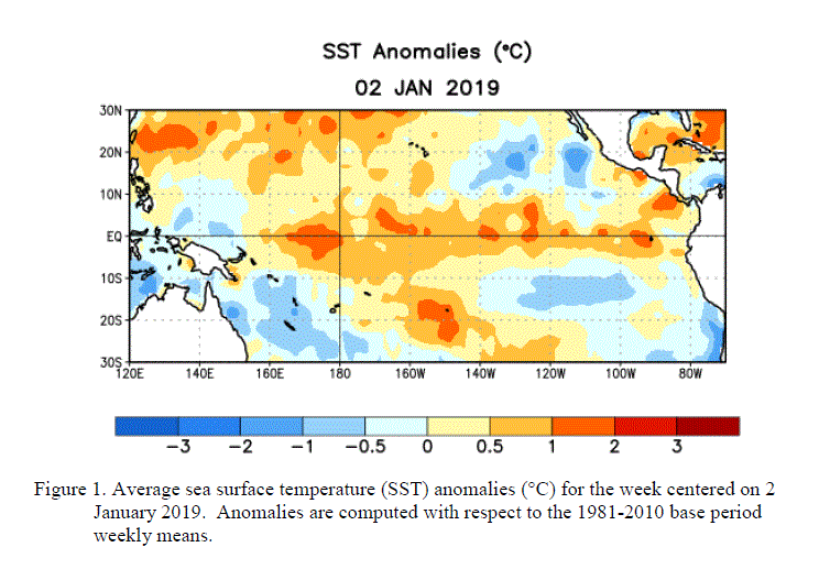
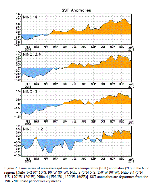
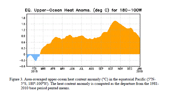
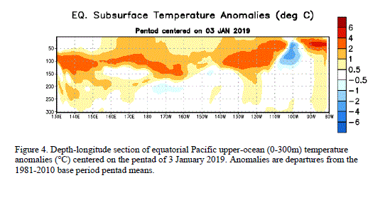
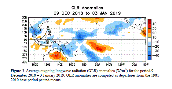
During May, sea surface temperatures (SST) anomalies increased across the central and eastern equatorial Pacific Ocean (Fig. 1 & Fig. 2). All of the Niño indices were in excess of +1.0oC, with the largest anomalies in the eastern Pacific, indicated by recent weekly values of +1.4oC in Niño-3 and +1.9oC in Niño-1+2 (Fig. 2). After a slight decline in April, positive subsurface temperature anomalies strengthened during May (Fig. 3) in association with the progress of a downwelling oceanic Kelvin wave (Fig. 4). In addition, anomalous low-level westerly winds remained over most of the equatorial Pacific, and were accompanied by anomalous upper-level easterly winds. The traditional and equatorial Southern Oscillation Index (SOI) were both negative, consistent with enhanced convection over the central and eastern equatorial Pacific and suppressed convection over Indonesia (Fig. 5). Collectively, these atmospheric and oceanic features reflect an ongoing and strengthening El Niño.
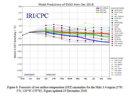
Nearly all models predict El Niño to continue throughout 2015, with many predicting SST anomalies to increase into the late fall 2015 (Fig. 6). For the fall and early winter, the consensus of forecasters slightly favors a strong event (3-month values of the Niño-3.4 index +1.5oC or greater), relative to a weaker event. However, this prediction may vary in the months ahead as strength forecasts are the most challenging aspect of ENSO prediction. A moderate, weak, or even no El Niño remains possible, though at increasingly lesser odds. There is a greater than 90% chance that El Niño will continue through Northern Hemisphere fall 2015, and around an 85% chance it will last through the 2015-16 winter.
Across the contiguous United States, temperature and precipitation impacts associated with El Niño are expected to remain minimal during the Northern Hemisphere summer and increase into the late fall and winter (the 3-month seasonal outlook will be updated on Thursday June 18th). El Niño will likely be a contributor to a below normal Atlantic hurricane season, and above-normal hurricane seasons in both the central and eastern Pacific hurricane basins.
This discussion is a consolidated effort of the National Oceanic and Atmospheric Administration (NOAA), NOAA's National Weather Service, and their funded institutions. Oceanic and atmospheric conditions are updated weekly on the Climate Prediction Center web site (El Niño/La Niña Current Conditions and Expert Discussions). Forecasts are also updated monthly in the Forecast Forum of CPC's Climate Diagnostics Bulletin. Additional perspectives and analysis are also available in an ENSO blog. The next ENSO Diagnostics Discussion is scheduled for 9 July 2015. T
