Questions were asked about some fallen trees near the Tioga entrance on another Forum (Whitney Zone) and I thought that the extensive answer/retrospective given by longtime backcountry ranger George Durkee was interesting (he used to man the Ostrander Hut).
http://www.whitneyzone.com/wz/ubbthreads.php/topics/1604/Re_Mysterious_fallen_trees_nea#Post1604
Fun reads and interesting information about Ostrander Hut compiled by George:
http://www.ostranderhut.com/
Edited 1 time(s). Last edit at 01/08/2010 11:35PM by Bee.

The Moon is Waxing Gibbous (72% of Full)
Re: Mysterious Fallen Trees Near Tioga Entrance
All posts are those of the individual authors and the owner
of this site does not endorse them. Content should be considered opinion
and not fact until verified independently.
January 08, 2010 11:25PM | Moderator Registered: 15 years ago Posts: 1,347 |
January 09, 2010 09:07AM | Moderator Registered: 15 years ago Posts: 1,918 |
 )
)January 09, 2010 12:47PM | Registered: 14 years ago Posts: 7,421 |

January 09, 2010 12:59PM | Moderator Registered: 15 years ago Posts: 1,347 |
January 09, 2010 02:02PM | Admin Registered: 15 years ago Posts: 17,051 |
|
Re: Mysterious Fallen Trees Near Tioga Entrance January 09, 2010 02:48PM | Registered: 15 years ago Posts: 384 |
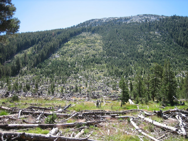
The eleven day February 1986 storm that left avalanche debris in the form of tree trunks all over the Central and Southern Sierra easily created the greatest Sierra avalanches during my lifetime. A few days after the storm we drove to Mammoth via SR-88 and US395 and there were still large piles of avalanche snow and debris from the high ravines above that had crossed US395 near Old Marina at Mono Lake and were incredibly laying in piles not far from the 6,700 foot elevation lakeshore water. In the town of Mammoth Lakes reaching our condo door entrance required walking through snow banks pathways on sidewalks far over our heads. The whole town was an unpresidented icebox. At Mammoth Mountain mind boggling avalanches had broke off the Cornice and one went an amazing distance down Dry Creek gully. The next summer I had to climb over several huge snow piles with tangled logs at the bottom of the South Fork of the San Joaquin River canyon between the JMT and Martha Lake. In Yosemite an avalanche off of Tressider Peak crossed Tenaya Creek tearing through a lodgepole pine grove, and ran up the other side of the canyon above highway SR-120 then the debris looped back down the opposite direction towards Tenaya Creek. One can still see the old logs in that meadow as well as Tioga Pass and many other places of the High Sierra.
Snipped below from this link:
http://en.wikipedia.org/wiki/Floods_in_California#February_1986:_Northern_California_and_western_Nevada_floods
February 1986: Northern California and western Nevada floods
On February 11, a vigorous low pressure system drifted east out of the Pacific, creating a Pineapple Express[2] that lasted through February 24 unleashing unprecedented amounts of rain on northern California and western Nevada.[3] The nine-day storm over California constituted half of the average annual rainfall for the year.[1] Record flooding occurred in three streams that drain to the southern part of the San Francisco Bay area.[3] Extensive flooding occurred in the Napa and Russian rivers. Napa, north of San Francisco, recorded their worst flood to this time[4] while nearby Calistoga recorded 29 inches (740 mm) of rain in 10 days, creating a once-in-a-thousand-year rainfall event.[2] Records for 24-hour rain events were reported in the Central Valley and in the Sierra. One thousand-year rainfalls were recorded in the Sierras.[1] The heaviest 24-hour rainfall ever recorded in the Central Valley at 17.60 inches (447 mm) occurred on February 17 at Four Trees in the Feather River basin.[2] In Sacramento, nearly 10 inches (250 mm) of rain fell in an 11-day period.[1] System breaks in the Sacramento River basin included disastrous levee breaks in the Olivehurst and Linda area on the Feather River.[1] Linda, about 40 miles (64 km) north of Sacramento, was devastated after the levee broke on the Yuba River's south fork, forcing thousands of residents to evacuate.[5] In the San Joaquin River basin and the Delta, levee breaks along the Mokelumne River caused flooding in the community of Thornton and the inundation of four Delta islands.[1] Lake Tahoe rose 6 inches (150 mm) as a result of high inflow.[3] The California flood resulted in 13 deaths, 50,000 people evacuated and over $400 million in property damage. [1] 3000 residents of Linda joined in a class action lawsuit Paterno v. State of California, which eventually reached the California Supreme Court in 2004. The California high court affirmed the District Court of Appeal's decision that said California was liable for millions of dollars in damages.[5
And a snippet at this site:
http://rds.yahoo.com/_ylt=A0oGk77JAklLjQEAmitXNyoA;_ylu=X3oDMTByN2s4bDgzBHNlYwNzcgRwb3MDNARjb2xvA3NrMQR2dGlkAw
Particularly notable are the sites in California’s Sierra Nevada range, where
snowfall totals ranged from 2 to 3.5 m, water from rain and snow exceeded 0.75 m,
and winds peaked at 270 kilometers per hour (Williams, 1986). All the California
WWAN sites we analyzed recorded total avalanche hazard indices exceeding 1000
for February 1986. Mammoth Mountain had perhaps the most extreme month of
any of the sites, with a hazard index over four times greater than the February 75th
percentile. One large slide at Mammoth reportedly released over 6 m deep at the
crown face, though Frutiger (1990) estimates an average slab depth for this slide of
about 2.8 m. Avalanches throughout the Sierra Nevada range destroyed thousands
of hectares of mature timber (some up to 300 years old), damaged ski lifts and other
buildings, and buried kilometers of highways (Wilson, 1986). Numerous slides ran
farther than expected; in one case a slide ran more than 100 m past the maximum
extent of the mapped runout zone (Frutiger, 1990).
===================================================================
David Senesac
http://www.davidsenesac.com
Edited 2 time(s). Last edit at 01/09/2010 02:51PM by DavidSenesac.
January 09, 2010 04:49PM | Moderator Registered: 15 years ago Posts: 1,347 |
|
Re: Mysterious Fallen Trees Near Tioga Entrance January 09, 2010 05:55PM | Registered: 14 years ago Posts: 154 |
I'm doing this from memory, & I haven't found info on the web, so please be gentle.
In 1863 or thereabouts, Donnelly ridge (South of the South Fork of the Kaweah) had a pretty good snow load. The ridge is about 1 1/2 miles long.
There were early heavy rains that essentially brought the whole ridge down through Avalanche Canyon to the Kaweah. The resulting mess dammed the river and a large volume of water built up behind it. Eventually the dam broke, sweeping Giant Sequoias down almost as far as Visalia.
If anybody has amendments & cites, feel free.
Edited 1 time(s). Last edit at 01/09/2010 07:47PM by wagga.
January 09, 2010 07:08PM | Admin Registered: 15 years ago Posts: 17,051 |
Quote
wagga
I'm doing this from memory, & I haven't found info on the web, so please be gentle.
In 1863 or thereabouts, Donnelly ridge (South of the South Fork of the Kaweah) had a pretty good snow load. The ridge is about 1 1/2 miles long.
There were early heavy rains that essentially brought the whole ridge down through Avalanche Canyon to the Kaweah. The resulting mess damned the river and a large volume of water built up behind it. Eventually the dam broke, sweeping Giant Sequoias down almost as far as Visalia.
If anybody has amendments & cites, feel free.
Your memory goes back to 1863?
|
Re: Mysterious Fallen Trees Near Tioga Entrance January 09, 2010 07:39PM | Registered: 14 years ago Posts: 154 |
January 11, 2010 08:52PM | Moderator Registered: 15 years ago Posts: 1,918 |
January 11, 2010 09:49PM | Moderator Registered: 15 years ago Posts: 1,347 |
January 13, 2010 06:09AM | Moderator Registered: 15 years ago Posts: 1,918 |
No problemo. I peeked over there and looked at at "what peakies" you hike...Quote
Bee
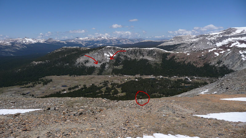
That Virginia Canyon shot is the best example of the "pile up" of trees that everyone talks about in the avalanche areas. I may cross reference the WZ thread back over here so they can see some of these pics.
b
And I thought I was nuts. Chick-on is calling me a lazy butt now.
January 13, 2010 05:53PM | Moderator Registered: 15 years ago Posts: 1,347 |
Quote
bill-e-g
No problemo. I peeked over there and looked at at "what peakies" you hike...
And I thought I was nuts. Chick-on is calling me a lazy butt now.
We need to rig up some sort of "throne" for Chick-on to ride atop your hat in all his regal glory!
B
Edited 1 time(s). Last edit at 01/13/2010 05:53PM by Bee.
January 13, 2010 07:50PM | Moderator Registered: 15 years ago Posts: 1,876 |
January 13, 2010 08:49PM | Registered: 14 years ago Posts: 7,421 |
January 13, 2010 08:51PM | Admin Registered: 15 years ago Posts: 17,051 |
January 12, 2010 08:05AM | Moderator Registered: 15 years ago Posts: 1,918 |


Sorry, only registered users may post in this forum.

