Going with a friend to little yos. valley Thurs. Probably check out Clouds Rest etc. After camping on Mt Shasta last weekend and putting up with very deep snow right from the parking lot, and 92 mph gusts at the 8000' treeline, I'm preparing for alot of snow down there as well. I told my friend to bring some extra cord so he could anchor his tent in the snow, but he said he'd be surprised if there's much snow at little yos. valley. Anyone been up there lately? Also, I'm thinking snowshoes might be a requirement for hiking up to cloud's rest. Postholing kills me.
Thanks

The Moon is Waxing Gibbous (58% of Full)
Re: Diving Board
All posts are those of the individual authors and the owner
of this site does not endorse them. Content should be considered opinion
and not fact until verified independently.
|
Little Yosemite Valley Snow Level May 04, 2010 04:20PM | Registered: 15 years ago Posts: 37 |
May 04, 2010 06:29PM | Moderator Registered: 15 years ago Posts: 1,918 |
Roland,
You don't come around much...
LYV will have little to no snow. You'll be able to hike all the way to the Clouds Rest Junction off the JMT
in your hiking boots. About two weeks ago that is where the snow really started.
Bring your snowshoes. Even though it is south facing I'd bet you'll still hits lots o snow
prob. a good 1500 ft below Clouds. And that's if your lucky. Even last year there was snow.
And with more than last yr you'll posthole more. It's just to early IMO to not bring snowshoes.
Better to have them than wish u had them.
|
Re: Little Yosemite Valley Snow Level May 05, 2010 08:19AM | Registered: 15 years ago Posts: 37 |
Hey Dale,
Thanks for the update. I was supposed to come out there in March for a Sierra Club outing, but had some issues to deal with here. Legal stuff with lawyers etc., so I had to cancel. Now I realize my only escape from them is to just pack up and go where I can't be reached and hope they just do their job.
I'm definitely bringing my snowshoes, and I can't wait to get out there. Shasta was great, though it was windy, it's always a trip to experience the awesome power of these places. I saw a couple of climbers through my binoculars literally get knocked on their butts by a blast of wind hurtling down the lee side of the mountain. The rangers said tents were getting blown right off the upper areas, and one was snapped in half (metal pole).
My friend wants to try Half Dome with the cables down. I don't think he will once he sees how steep it is. He's as big a coward as I am. Needless to say, just being on the saddle is a great view, though maybe we can see if we can find the diving board instead. I've always wanted to try and find it. Sounds like you need to bushwack off of the trail near the ranger hut at the top of nevada fall.
We're going to stay at the Bug tonight, and head out in the morning. How have you been? You must've seen alot of snow this year down there. The waterfalls must be roaring right now.
May 05, 2010 09:49AM | Moderator Registered: 15 years ago Posts: 1,918 |

Uh... that's not a ranger hut at the top of Nevada.
Buddie of mine keeps telling me he is gonna go to Henry Coe and not bring a tent during rainy season.
Gonna sleep in one of the bathrooms. I tell him "good luck with that".
Anywho. Somehow got the wife interested in snow camping this year. (Sweet Victory)
Check this out:
http://picasaweb.google.com/yosemite.chick.onr/Matthes
As you know... so beautiful in "winter".
Few other words re. your trip. The subdome def. gonna have major snow on it still. Problem with
snowshoes is that there are alot of people who will posthole along. This make snowshoeing
a pain in the rear too. Just expect snow on the subdome.
Diving Board... You wanna hit Lost Lake. Go almost all the way to the LYV trail split and then
head to Lost Lake. From there just look for ducks. Without climbing shoes expect to
climb all the way to the rock... then climb back down... then zig over into the trees and up.
Won't need snowshoes to go there fwik.
Heading up Friday ... no idea where going yet (typical)... only got 2 days... too bad can't go tmr.
or I'd take you up the board. Heck. might just do that Fri w/ the bird.
Either that or maybe Olmsted.
Have fun
Edited 1 time(s). Last edit at 08/17/2011 07:20PM by bill-e-g.
|
Re: Little Yosemite Valley Snow Level May 05, 2010 10:01AM | Registered: 15 years ago Posts: 37 |
Hey Dale,
My hiking buddy just called me and said he's sick as a dog and can't go. Dang. Still heading out. All packed up and ready to go. That's great that your wife is getting into snowcamping. Very beautiful out there, and since most people don't like the cold, you have it all to yourself. Mostly. Anyway, if you're up that way Friday maybe we can hook up. My plan was to spend Thur and Friday night up at LYV, and hike out Saturday.
My tel is 415-254-0098.
Later,
Roland
|
Re: Diving Board May 05, 2010 11:22AM | Registered: 15 years ago Posts: 60 |
Hey Roland,
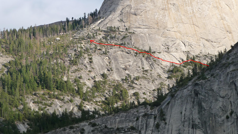
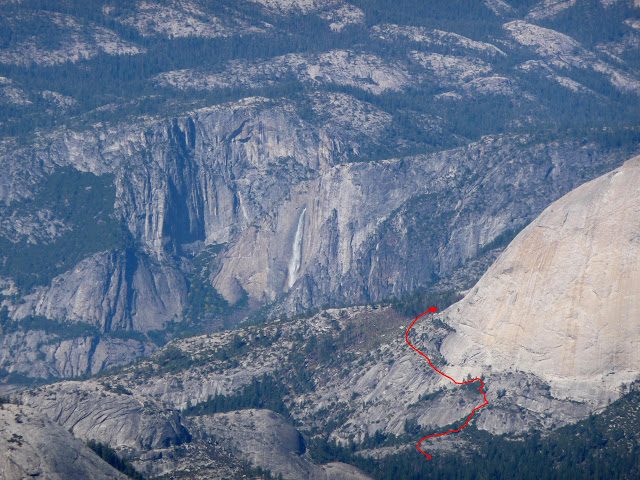
You can find my description of the route to the Diving Board on the west shoulder of Half Dome (as well as the base of the Snake Dike route) here:
http://www.whitneyportalstore.com/forum/ubbthreads.php/ubb/showflat/Number/53868#Post53868
There is also a "Guano Route" variation starting from the trail at the base of the Nevada Fall switchbacks.
You can see my YouTube video taken from the Diving Board area, too -- same place Ansel Adams took his Half Dome "Monolith" picture.
____________________________________
WhitneyZone -- Mt Whitney Hikers Association
Edited 1 time(s). Last edit at 05/05/2010 11:25AM by SteveC.
May 05, 2010 11:44AM | Moderator Registered: 15 years ago Posts: 1,918 |
Steve,
Posted this last yr:
http://yosemitenews.info/forum/read.php?1,9251,page=1
(the map shows what we did... (the stuff going west of Mt. Brod was just bopping around))
Hopefully the pix are accessible...
http://picasaweb.google.com/yosemite.chick.on/DivingBoard09
Edited 2 time(s). Last edit at 08/17/2011 07:21PM by bill-e-g.
|
Re: Diving Board May 05, 2010 12:05PM | Registered: 15 years ago Posts: 60 |

|
Re: Diving Board May 05, 2010 05:42PM | Registered: 15 years ago Posts: 37 |
|
Re: Diving Board May 05, 2010 05:46PM | Registered: 15 years ago Posts: 60 |
May 05, 2010 06:28PM | Admin Registered: 15 years ago Posts: 17,050 |
May 05, 2010 06:35PM | Moderator Registered: 15 years ago Posts: 1,942 |
Quote
SteveC
What is the "Yosemite Bug"???
http://www.yosemitebug.com/
The cure for a fallacious argument is a better argument, not the suppression of ideas.
-- Carl Sagan
|
Re: Diving Board May 10, 2010 08:44PM | Registered: 15 years ago Posts: 37 |
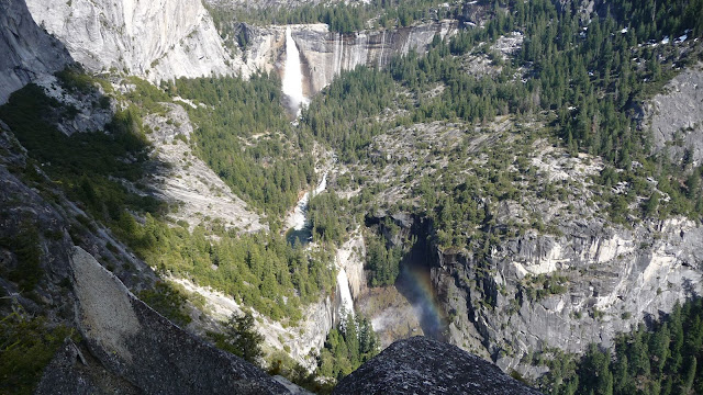
Well, I made it to the Diving Board with the help of SteveC's excellent picture of the traverse across the southern face of half dome, and Chick-On to lead the way, otherwise Bill-e-g and I might still be wandering around up there. The view from the diving board was fantastic. Seeing the sheer face of half dome up close is something that you really can't see anywhere else, even from the top; which is where everyone else was going that morning even though several of us at LYV told them too much snow on the sub-dome, and the cables were down. Couldn't believe how many people seemed surprised the cables were down. Doesn't anyone ask before hiking miles and thousands of feet up.
Since Chick-On was hanging out at the diving board for the night taking pictures of Turlock (or Patterson), I elected a safer bushwhacking (got whacked by a lot of bushes) route back down with a photographer, David, and his daughter Christie, who were also up there taking photos. They marked the route from hell with innumerable ducks when they came up. They didn't want the exposure of the traverse. After a couple hours and a thousand manzanita lashes, we got back to LYV and the sound of numerous Santa Barbara college girls giggling and laughing the rest of the afternoon and into the night. They were with some Adventure Guide outfit. I fell asleep anyway, until one the guides or someone jumped out of one of the solar toilets and growled at them as they went to use them. The screams were so loud that if there were any bears around they scattered to safer latitudes. Someone even noticed some bear poop by the outhouse the next morning. Literally scared the crap out of him.
Got up the next morning, went around the gate at the John Muir Trail (like everyone else that morning), and avoided the lines of people coming up Nevada and Vernal Falls. I was stunned by how many people were on the trail from the bridge back to Happy Isles. Where did they all come from?
May 10, 2010 09:04PM | Registered: 14 years ago Posts: 7,421 |
Yeah, had to drag bill-e-boy and Roland up to da dive-on bird.
Steve, dunno why u call it Guano Route. Went that way and, yowza!
LOVE LOVE LOVE THAT WAY. Shootin da Gap between Lib and Brob
is THE way to go. < 1 3/4 hr to Lost Lake from da Valley. Nice.
Thanks for the mappy. The NE traverse isn't as bad as it looks.
Just a couple of moves and you're there.
Later went to Grizzly Peak which was a little more hare raisin.
Stupid bill-e-boy left me behind the last couple hundred feet. Turkey!
Fallz are a gushing!
May 10, 2010 09:07PM | Admin Registered: 15 years ago Posts: 17,050 |
|
Re: Diving Board May 10, 2010 10:32PM | Registered: 15 years ago Posts: 60 |
Quote
chick-on
Steve, dunno why u call it Guano Route. Went that way and, yowza!
LOVE LOVE LOVE THAT WAY. Shootin da Gap between Lib and Broderick
is THE way to go. < 1 3/4 hr to Lost Lake from da Valley. Nice.
Thanks for the mappy.
You didn't find the Guano? Check out Laura (MooseTracks') picture album here: Yosemite Valley, 10/10-12/08
The route starts at picture 100 (titled "Bugger of a Pack) When you leave the Nevada Falls trail at the Liberty Cap apron, in about 10 minutes you are at the pile of bat guano!.
Heres the picture:

From Mars wrote:
> Since Chick-On was hanging out at the diving board for the night taking pictures of Turlock (or Patterson)...
Two questions:
1. Is water available up there? It was bone-dry in October. Fine place to camp though!
2. Any chance we might see some pictures of Turlock/Patterson?
Edited 1 time(s). Last edit at 05/10/2010 11:00PM by SteveC.
May 11, 2010 06:26AM | Moderator Registered: 15 years ago Posts: 1,918 |
Quote
SteveC
Two questions:
1. Is water available up there? It was bone-dry in October. Fine place to camp though!
2. Any chance we might see some pictures of Turlock/Patterson?
Steve,
Now with your picture of the Guano ... got it. I didn't really notice any bat poo but I did see
the pieces of PVC pipe and just said to myself "what da heck are these doing here?"
so I know where it is. I'll go by there next time I'm up that way and now know. Maybe it
was sorta covered by leaves or it washes away with the winter snow/rain and I just
took it for dirt???
Some of the pipes were just laying on the ground.
Took a picture of the duck in the tree too. It's still sitting there. Thought that was kinda cool.
re: your questions
1. There's a small stream up there that runs for a bit in the early spring. So, yes, no need
to carry up water early. Found that out previous April when went up for first time and
carried a few larries up there taken from Lost Lake needlessly.
2. There is another thread with a picture. You no see?
Here's a select few from the trek:
http://picasaweb.google.com/yosemite.chick.on/DiveOnBoard
Thanks again for the map. Def. saved some time. Wifey and I went ALL the way to the
base the first time and missed the "first SE traverse part". You won't know it though
because there are loads of ducks everywhere.
eeek: someone had to watch the pack so bird stayed below (not always certain
where gonna spend the night so I'll take everything with me...) (what's another 1000ft back up?)
May 11, 2010 12:45PM | Registered: 14 years ago Posts: 173 |
I shared this with Dale the night he headed up there but I think, Roland, you may like it as well. Enjoy this bit of footage of Ansel and friends:
http://www.sfmoma.org/multimedia/videos/114
I don't know if this Burro can get his knees up and over that one spot that was mentioned to me. Perhaps, I may follow the ducks if I get to tag along next time.
Cheers,
-L.
http://www.sfmoma.org/multimedia/videos/114
I don't know if this Burro can get his knees up and over that one spot that was mentioned to me. Perhaps, I may follow the ducks if I get to tag along next time.
Cheers,
-L.
|
Re: Diving Board May 11, 2010 01:29PM | Registered: 15 years ago Posts: 60 |
Wow, Burro! That is a great video. Adams himself!
Have to chuckle at their using ropes. But the edge at the lip is truly steep -- it was too steep for me to walk along. One could hold the lip and move sideways, but then it goes for several hundred feet.
Seriously, that one tough spot is only 5 or 6 feet high, and it is at a slope that you can almost climb. If you have a friend or two along, you can easily help each other. maybe a simple 10-foot section of rope or webbing would help.
You don't want to follow the ducks -- they're everywhere, and lead nowhere (we tried)! You'll either get into even steeper terrain or do a whole lot of unnecessary bushwhacking.
May 11, 2010 01:46PM | Moderator Registered: 15 years ago Posts: 1,918 |
What you have to realize in that video is that they went up to Grizzly Point first.
If you take a look at the pictures I took and the captions and then correlate it to
the video it should be clear.
In other words, they went straight up the gulch that runs SE from HI to the saddle
just E of Grizzly. (add that to the list of todo items...)
If you take a look at the pictures I took and the captions and then correlate it to
the video it should be clear.
In other words, they went straight up the gulch that runs SE from HI to the saddle
just E of Grizzly. (add that to the list of todo items...)
|
Re: Diving Board May 11, 2010 02:33PM | Registered: 15 years ago Posts: 60 |
May 11, 2010 06:21PM | Moderator Registered: 15 years ago Posts: 1,918 |
Steve, ya been up Sierra Pt. a couple times. From what I was told Ansel went up to Sierra Pt. first
and then up to the Diving Board. Probably this video is a re-creation of that.
I question if he went to Sierra Pt. first going by this video. My guess is that he went to Grizzly Pt. first and
someone who told that to me is a bit mistaken.... or that trail may have gone a different way a bit.
My guess on the video is that it is spliced a bit out of order. The first 12 seconds look like
they are taken from the saddle E of Grizzly. :12-:29 look like the traverse up to that sadde.
:30 is definitely atop Grizzly Peak.
If I happen to attempt that route up I'll post something...
Edited 1 time(s). Last edit at 05/11/2010 07:32PM by bill-e-g.
May 16, 2010 10:52AM | Moderator Registered: 15 years ago Posts: 1,918 |
May 16, 2010 10:53AM | Moderator Registered: 15 years ago Posts: 1,918 |
Sorry, only registered users may post in this forum.

