
All posts are those of the individual authors and the owner
of this site does not endorse them. Content should be considered opinion
and not fact until verified independently.
June 14, 2010 08:18PM | Registered: 14 years ago Posts: 7,421 |
Saturday, June 12th
|
Re: Grand Canyon of The Tuolumne June 14, 2010 09:24PM | Registered: 13 years ago Posts: 4 |
June 14, 2010 09:56PM | Moderator Registered: 15 years ago Posts: 1,918 |
OK. Here is the story.
We walked into the permit station on Friday and I said, "Glen Aulin Passthru please".
Ranger said "o... you won't get past Delany or Dingley" to which I said
"that's fine... I'm not going that way". Explained going via Little Devils Postpile...
then she says... "ranger went thru there <don't know> and he couldn't get past
Waterwheels". I questioned this b/c it made no sense to me. Then said.. don't care...
we'll deal with it... worse case is that we don't even make it to Twin Bridges
and we have to come back out... then we'll just get something else tomorrow
and snowshoe into Cathedral or wherever.... it's all good.
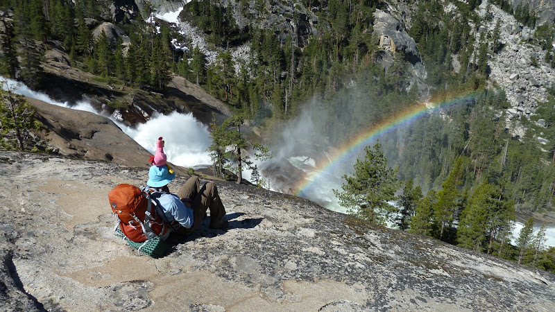
So... on Friday we hiked all the way to where Cathedral Creek flows into the
Tuolumne (where the video was taken by the bird).
Next day we were gonna dayhike to Pate and back... but... we got to Register
and it was flowing nicely... and I went up to mid thigh in raging water and
the wifey yelled at me so I came back... we hiked down to the Tuolumne and
when we went back up she took a nose dive so when I found a huge log
above the waterfall she nixed continuing... so we went back and lounged.
Next day we leisurely hiked back up to Glen Aulin. Saw 4 day hikers.
(btw... say 3 dayhikers on day 1 near Little Devils... and they said they
took 2 hours to get from there to Twin Bridges... uh... it took us 10 mins tops)
Last day we hiked on west side of stream from HSC to Twin Bridges
then back out via Little Devils.
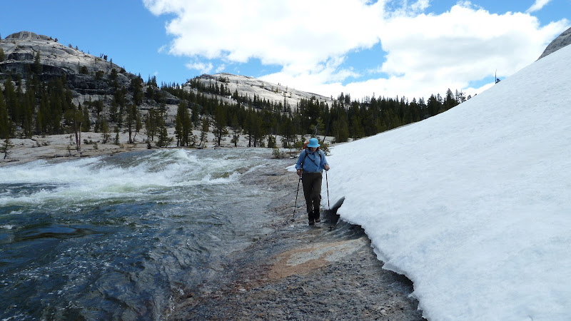
There was snow up until Twin Bridges but we didn't use any special gear
other than hiking sticks. Typical flooding near Mattie outlet area which
you can get by via logs on first part and going into the rocks for the second part.
Some snow on west side below Twin Bridges.
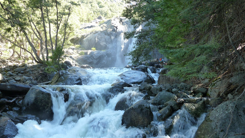
Now, your experience may vary. They highest flow is just amazing.
Huge trees right in the trail. Lots of driftwood on the trail as you continue below Return.
Not sure what else to say... not many bugs... but they are starting...
We'll put up some more pictures...
We walked into the permit station on Friday and I said, "Glen Aulin Passthru please".
Ranger said "o... you won't get past Delany or Dingley" to which I said
"that's fine... I'm not going that way". Explained going via Little Devils Postpile...
then she says... "ranger went thru there <don't know> and he couldn't get past
Waterwheels". I questioned this b/c it made no sense to me. Then said.. don't care...
we'll deal with it... worse case is that we don't even make it to Twin Bridges
and we have to come back out... then we'll just get something else tomorrow
and snowshoe into Cathedral or wherever.... it's all good.
So... on Friday we hiked all the way to where Cathedral Creek flows into the
Tuolumne (where the video was taken by the bird).
Next day we were gonna dayhike to Pate and back... but... we got to Register
and it was flowing nicely... and I went up to mid thigh in raging water and
the wifey yelled at me so I came back... we hiked down to the Tuolumne and
when we went back up she took a nose dive so when I found a huge log
above the waterfall she nixed continuing... so we went back and lounged.
Next day we leisurely hiked back up to Glen Aulin. Saw 4 day hikers.
(btw... say 3 dayhikers on day 1 near Little Devils... and they said they
took 2 hours to get from there to Twin Bridges... uh... it took us 10 mins tops)
Last day we hiked on west side of stream from HSC to Twin Bridges
then back out via Little Devils.
There was snow up until Twin Bridges but we didn't use any special gear
other than hiking sticks. Typical flooding near Mattie outlet area which
you can get by via logs on first part and going into the rocks for the second part.
Some snow on west side below Twin Bridges.
Now, your experience may vary. They highest flow is just amazing.
Huge trees right in the trail. Lots of driftwood on the trail as you continue below Return.
Not sure what else to say... not many bugs... but they are starting...
We'll put up some more pictures...
June 14, 2010 09:57PM | Moderator Registered: 15 years ago Posts: 1,918 |
June 14, 2010 09:59PM | Moderator Registered: 15 years ago Posts: 1,918 |
June 14, 2010 10:00PM | Moderator Registered: 15 years ago Posts: 1,918 |
June 14, 2010 10:02PM | Moderator Registered: 15 years ago Posts: 1,918 |
|
Re: Grand Canyon of The Tuolumne June 14, 2010 10:44PM | Registered: 13 years ago Posts: 21 |
June 15, 2010 07:28AM | Moderator Registered: 15 years ago Posts: 1,918 |
|
Re: Grand Canyon of The Tuolumne June 15, 2010 11:05AM | Registered: 14 years ago Posts: 24 |
June 15, 2010 11:15AM | Moderator Registered: 15 years ago Posts: 1,918 |
Quote
DanTheMan
What kind of program do you use to produce this?
It's Topo!
National Geographic bought them out a few years back.
I guess it's this:
http://www.rei.com/product/737657
I keep my GPS on whenver I'm hiking....
June 21, 2010 07:33AM | Registered: 15 years ago Posts: 145 |
Quote
bill-e-g
Quote
DanTheMan
What kind of program do you use to produce this?
It's Topo!
National Geographic bought them out a few years back.
I guess it's this:
http://www.rei.com/product/737657
I keep my GPS on whenver I'm hiking....
I have NG TOPO, too - you can also view GPS tracks in Google Earth (free).
A GPS, window seat and maps also make airline travel fun!
|
Re: Grand Canyon of The Tuolumne June 14, 2010 10:40PM | Registered: 13 years ago Posts: 4 |
June 15, 2010 06:51AM | Moderator Registered: 15 years ago Posts: 1,918 |
June 15, 2010 07:02AM | Moderator Registered: 15 years ago Posts: 1,918 |
|
Re: Grand Canyon of The Tuolumne June 15, 2010 08:21AM | Registered: 13 years ago Posts: 2 |
eeek, chick-on, and bill-e-g make this forum an awesome place for all of us to go for trail condition. Thanks a lot!
Does anyone have pictures or trail conditions for Lyell Canyon or Rafferty Creek trails. I have a Lyell Canyon permit starting 6/19 and am concerned. I like a good challenge and am not worried to much about cold or fitness but is Ireland Lake doable yet? Is Rafferty Creek to Vogelsang HSC and then down to Merced Lake possible?
Thanks for any help!
June 15, 2010 11:02AM | Moderator Registered: 15 years ago Posts: 1,918 |
June 15, 2010 11:07AM | Moderator Registered: 15 years ago Posts: 1,918 |
For the record. I didn't say that Dingley and Delany were not possible to cross.
We didn't cross them... we avoided them.
What I was told by someone who did cross them (and from what we saw nearly
no one crossed them) was that they were ankle to mid calf deep and running fast.
That's the extent of what I know.
The ranger giving us the permit said it would be an issue.
Also, I highly recommend going Glen Aulin all the way to Pate (or as far as you like),
turn around... and come back. I've said this a number of times in the past...
you do not see the same things on an out and back. It's a different experience.
And shuttle trips suck anyway.
|
Re: Grand Canyon of The Tuolumne June 15, 2010 12:38PM | Registered: 13 years ago Posts: 4 |
I'm betting Lyell Canyon is fine, but heading up to Ireland will be tough. I did the same trip at the same time of year in the late 90s. Forget the exact year but it was a heavy snow one like this. We had dinner reservations at Vogelsang but it had a delayed opening so no steak dinner! You could call to ask when or if Vogelsang is open and that should give you a good idea of the snowpack.
We ended up camping in Lyell and taking day trips to the snow. It was a blast.
BTW, I have permits for Glen Aulin starting on the 19th but may try to move to Lyell due to the high waters in the canyon. I have a couple of kids in my group and don't want to take chances.
We ended up camping in Lyell and taking day trips to the snow. It was a blast.
BTW, I have permits for Glen Aulin starting on the 19th but may try to move to Lyell due to the high waters in the canyon. I have a couple of kids in my group and don't want to take chances.
June 15, 2010 01:43PM | Registered: 14 years ago Posts: 7,421 |
Beyond Glen Aulin the trail only had water in it at the Mattie outlet area.
Everything else was zero water. 100% clear. You'll get more mush in Lyell for sure.
Regardless. Have fun. Be Safe.
A few other notes:
- it's early spring in Glen Aulin... the bugs are starting
- below Return Creek the Wildcat Fire from last year is prevalent. Not a big deal but
just mentioning it ... some big trees died in some areas... but in other the big
trees didn't die.. it a few years it'll zoom back.
- as you go further down the Canyon the season progresses...
Enjoy
June 15, 2010 10:15PM | Moderator Registered: 15 years ago Posts: 1,918 |
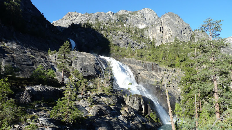
For your enjoyment... here's a set with captions.
http://picasaweb.google.com/yosemite.chick.on/GCTuolumne
tomdisco... take a close look at #11.
http://picasaweb.google.com/yosemite.chick.on/GCTuolumne
tomdisco... take a close look at #11.
June 16, 2010 10:02AM | Registered: 15 years ago Posts: 1,876 |
Quote
bill-e-g
For your enjoyment... here's a set with captions.
http://picasaweb.google.com/yosemite.chick.on/GCTuolumne
tomdisco... take a close look at #11.
Yes, it's remarkable how the angle is just right to split the two Whorl Mountain peaks to glimpse Matterhorn. Thanks for the many early season photos. On the the first photo of Cathedral Creek is the Ten Lakes trail just out of sight over the distant ridge?
June 16, 2010 11:46AM | Moderator Registered: 15 years ago Posts: 1,918 |
Quote
tomdisco
Yes, it's remarkable how the angle is just right to split the two Whorl Mountain peaks to glimpse Matterhorn. Thanks for the many early season photos. On the the first photo of Cathedral Creek is the Ten Lakes trail just out of sight over the distant ridge?
Yes, the Ten Lakes trail is just over that ridge.
Take a look at it in Google Earth. Falls Ridge is very impressive.
I spied it from Wildcat Pt. a couple years ago. Two huge canyons... the GC and.. Cathedral Creek ..
(it's on my list of stuff to go check out)
(and did you know Vernal Falls was on Falls Ridge... Wha!!?!?) (I gave up trying to get them in the right location btw)
Anyway...
So, yeah, I was wrong. You CAN see Matterhorn from just below the Twin Bridges.
But.. but... but... that photo is 16x Zoom. So unless you have Binocs or Chick-on eyes....
|
Re: Grand Canyon of The Tuolumne June 15, 2010 11:19PM | Registered: 13 years ago Posts: 4 |
|
Re: Grand Canyon of The Tuolumne June 19, 2010 10:48AM | Registered: 13 years ago Posts: 2 |
June 20, 2010 03:46PM | Moderator Registered: 15 years ago Posts: 1,918 |
|
Re: Grand Canyon of The Tuolumne June 21, 2010 06:45AM | Registered: 13 years ago Posts: 5 |
bill-e-g, thanks for the pictures and info! I am going with 2 others this weekend and plan on doing your same route to get to WW falls and beyond.
I'm interested in the Goatineers Route you took in, is it pretty easy to catch the trail for this? Trying to get an idea if we will be able to find it or not. Thanks
I'm interested in the Goatineers Route you took in, is it pretty easy to catch the trail for this? Trying to get an idea if we will be able to find it or not. Thanks
June 21, 2010 07:22AM | Moderator Registered: 15 years ago Posts: 1,918 |
Quote
g6t6o
bill-e-g, thanks for the pictures and info! I am going with 2 others this weekend and plan on doing your same route to get to WW falls and beyond.
I'm interested in the Goatineers Route you took in, is it pretty easy to catch the trail for this? Trying to get an idea if we will be able to find it or not. Thanks
Bee will probably like this one.
Don't expect to follow any trail... so if you need a trail... then it's probably not your cup of tea.
There is a trail but parts of it are really badly routed. If you take a look at this:
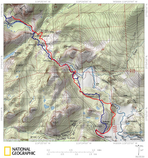
http://picasaweb.google.com/yosemite.chick.on/GCTuolumne#5483231355278564370
You will see the two ponds to the left of the blue trail there. The trail starts approx at BM 8639.
It then goes to the right of the first pond.. then heads towards BM 8854, going over the steep
saddle there. From there it goes thru a nice swampy area left of the second pond.
Now if you find the TUOLUMNE writing.. see that little pond there? Well... right now that
is one big ol lake. The "real" trail goes to the right /east of that.
Sooooo.... don't expect to follow a trail. It got called the Goatineers Route by Bee I beeeeleive
b/c Theee Old Dude, her, and I started on the real trail... and I pretty much said
we wanna be up there! (Pothole Dome)... it was a little scamble to get up there
(some whining from what I remember) hahaha.. Anyway... I much much much prefer going
up Pothole (you can park at BM 8565) then working along as many domage and
granite as you can. It's up and down... but it's fun. The route in that link above was
kinda what I recommended to avoid some of the domes ... but I REALLY recommend
having fun and kinda going along as many as you can.
Here's a map with what I just described as the real trail:
http://picasaweb.google.com/yosemite.chick.on/GCTuolumne#5485231325213315666
You have to expect a couple of "interesting" areas to go thru regardless of which way you go.
You should be able to use whatever GPS software and the maps above to create whatever
track you prefer... or I can send you whichever one you like.
O ... btw... by now plenty are going the main trail.. and there should be lots o data points
about that by the time you go.
Have fun
June 21, 2010 09:36PM | Moderator Registered: 15 years ago Posts: 1,347 |
Quote
bill-e-g
It got called the Goatineers Route by Bee I beeeeleive
b/c Theee Old Dude, her, and I started on the real trail... and I pretty much said
we wanna be up there! (Pothole Dome)... it was a little scamble to get up there
(some whining from what I remember) hahaha.. Anyway... I much much much prefer going
up Pothole (you can park at BM 8565) then working along as many domage and
granite as you can. It's up and down... but it's fun. Have fun
Yup. I coined it the "Goatineers Route" Beecause it is the shortest route beetween two points AND it will mostly keep yer hooves dry....and in the high season, you would avoid both the pack animal "apples" and the hordes of peeps. Camping up or near some domeage is nifty on the way out, too. Make sure that you have some Stick-'em on yer booties when you get near the Little Devils Postipile & near the reever -- it can get slick on that wet polished granite!
An excellent trip
The body betrays and the weather conspires, hopefully, not on the same day.

|
Re: Grand Canyon of The Tuolumne June 21, 2010 09:15PM | Registered: 15 years ago Posts: 384 |
Your image of "On the way to Little Devils Postpile: shows the one squeeze spot on that route. One can usually climb up and around that but it would just be icy steep snow now. An excellent view from the knob just above. I normally park west of Pothole and ramble through the saddle SE of East Cottage Dome. Would expect the flooded section of the west end of the bridge below LDP would be a bit scary to cross. Also hate wading through that dark flooded Maty section as its difficult to tell how deep each next step may be. In the 80s during big water years a couple times we backpacked a class 2 route all the way down to the west side of Le Conte and Waterwheel Falls via the Cathedral Creek drainage. But one needs to be an expert with the topo to avoid areas of obvious class 3+ friction slabs. Another challenge for those up to it. Would be a good time to climb up to Wildcat Point from Glen Aulin and say hi to those brookies in Mattie.
Edited 1 time(s). Last edit at 06/21/2010 09:16PM by DavidSenesac.
Edited 1 time(s). Last edit at 06/21/2010 09:16PM by DavidSenesac.
June 28, 2010 08:08PM | Registered: 13 years ago Posts: 426 |
June 28, 2010 08:14PM | Moderator Registered: 15 years ago Posts: 1,918 |
Quote
itchbay
Reading back through these posts, and I'm intrigued by the idea of a "Little Devil's Postpile." I'm assuming by the name that it's not as impressive as the one near Mammoth. Is that the case? Is this a worthy day hike from TM?
It's nowhere near as impressive. This is about as good as it gets there:
http://picasaweb.google.com/yosemite.chick.on/GCTuolumne#5483209919022894210
June 28, 2010 08:17PM | Registered: 13 years ago Posts: 426 |
June 28, 2010 08:15PM | Admin Registered: 15 years ago Posts: 17,050 |
Quote
itchbay
Reading back through these posts, and I'm intrigued by the idea of a "Little Devil's Postpile." I'm assuming by the name that it's not as impressive as the one near Mammoth. Is that the case? Is this a worthy day hike from TM?
Even without the postpile the area is worthy of a dayhike. But I'd start the hike from Pothole Dome.
June 28, 2010 08:19PM | Registered: 13 years ago Posts: 426 |
|
Re: Grand Canyon of The Tuolumne June 29, 2010 07:56AM | Registered: 13 years ago Posts: 5 |
Went from TM to Waterwheel this past weekend on the main trail, amazing trip. Hardly saw anyone on Thur and Fri, had our pick of the campsites pretty much. Stayed dry on the way in, was able to use logs anywhere that was wet. Coming out we just walked through, here was Delaney on Sunday afternoon.
|
Re: Grand Canyon of The Tuolumne June 29, 2010 12:46PM | Registered: 13 years ago Posts: 20 |
Just got back from a 3 day trip through the Grand Canyon of the Tolumne River. Arrived at Tuolumne meadow's backpacker's campground and stayed there for one night (campground is still officially closed but we just walked in and ste up camp...as did a few other groups).
On Saturday Morning, we left are car at t. meadows store and caught the 9:10 AM YARTS shuttle to white wolf- gate to White Wolf campground was closed so we had at least an extra mile to hike down the road to the trailhead.
Some quick notes about the conditions:
at white wolf Trails were wet in the white wolf campground area w/ a few patches of snow, but that only lasted 10 minutes or so
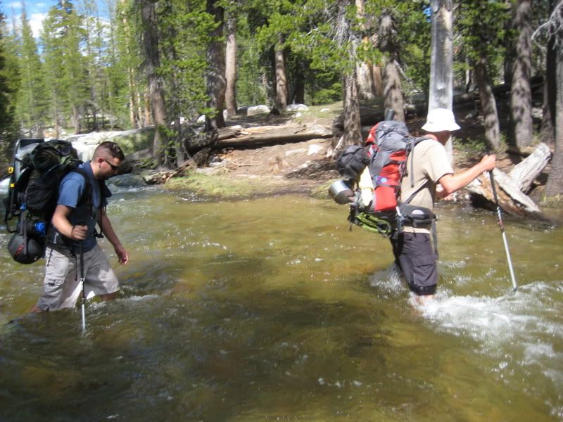
At one part along the trail, we encountered a couple who decided to turn around at Morrison and head back to white wolf because they weren't comfortable with the crossing, so we were a little intimidated. We reached morrison late in the afternoon. It was swift and about mid-calf deep, and somewhat challenging because it was the first real creek crossing I've ever attempted, but we didn't have trouble just walking right through with the help of our hiking poles. About 5-6 other people crossed the creek shortly after we did, and this included a couple 10-13 year old kids (though one of them did lose a sandal while trying to cross).
Once we headed down into Pate valley, parts of the trails were wet/muddy/swampy (walking through some still ankle-deep water) and a little overgrown. We took a wrong turn and were off track for at least 5-10 minutes or so in one part of this area, but it was OK overall, just a minor annoyance.
Register Creek was the only real challenging crossing, but again, we felt fine. It was noticeably swifter than Morrison. Again, about mid-calf deep, but we had to cross very close to the edge so recovering from a fall would have been tough. Other option would have been to cross at a safer distance away but it would have been nearly waist deep.
Delaney was a bit deeper than the other crossings, but it was an easy crossing, water not moving very fast at all compared to Register and Morrison.
A little before Glen aulin, a few parts of the trails were flooded again at some points almost knee deep (still water), but again, just a minor annoyance. We just walked through all the water on the trail rather than working around it.
Overall, I'm glad we chose to do this hike last week. You will get VERY wet, but I wouldn't let trail conditions deter you if you're already planning on heading up this weekend, especially if you're starting at Tuolumne meadows. Just be ready for a fun crossing at Register Creek. Waterfalls are all flowing nicely and the river is amazing.
I'lll get some pictures up later in the week.
Edited 3 time(s). Last edit at 06/29/2010 02:30PM by diesel.
On Saturday Morning, we left are car at t. meadows store and caught the 9:10 AM YARTS shuttle to white wolf- gate to White Wolf campground was closed so we had at least an extra mile to hike down the road to the trailhead.
Some quick notes about the conditions:
at white wolf Trails were wet in the white wolf campground area w/ a few patches of snow, but that only lasted 10 minutes or so
At one part along the trail, we encountered a couple who decided to turn around at Morrison and head back to white wolf because they weren't comfortable with the crossing, so we were a little intimidated. We reached morrison late in the afternoon. It was swift and about mid-calf deep, and somewhat challenging because it was the first real creek crossing I've ever attempted, but we didn't have trouble just walking right through with the help of our hiking poles. About 5-6 other people crossed the creek shortly after we did, and this included a couple 10-13 year old kids (though one of them did lose a sandal while trying to cross).
Once we headed down into Pate valley, parts of the trails were wet/muddy/swampy (walking through some still ankle-deep water) and a little overgrown. We took a wrong turn and were off track for at least 5-10 minutes or so in one part of this area, but it was OK overall, just a minor annoyance.
Register Creek was the only real challenging crossing, but again, we felt fine. It was noticeably swifter than Morrison. Again, about mid-calf deep, but we had to cross very close to the edge so recovering from a fall would have been tough. Other option would have been to cross at a safer distance away but it would have been nearly waist deep.
Delaney was a bit deeper than the other crossings, but it was an easy crossing, water not moving very fast at all compared to Register and Morrison.
A little before Glen aulin, a few parts of the trails were flooded again at some points almost knee deep (still water), but again, just a minor annoyance. We just walked through all the water on the trail rather than working around it.
Overall, I'm glad we chose to do this hike last week. You will get VERY wet, but I wouldn't let trail conditions deter you if you're already planning on heading up this weekend, especially if you're starting at Tuolumne meadows. Just be ready for a fun crossing at Register Creek. Waterfalls are all flowing nicely and the river is amazing.
I'lll get some pictures up later in the week.
Edited 3 time(s). Last edit at 06/29/2010 02:30PM by diesel.
June 29, 2010 01:26PM | Moderator Registered: 15 years ago Posts: 1,918 |
June 29, 2010 03:28PM | Moderator Registered: 15 years ago Posts: 1,876 |
Quote
diesel
A little before Glen aulin, a few parts of the trails were flooded again at some points almost knee deep (still water), but again, just a minor annoyance. We just walked through all the water on the trail rather than working around it.
Those two flooded sections are actually at the W end of Glen Aulin.
Glen Aulin is the valley, not the High Sierra Camp. (Check your topo map.)
The English translation of the name is "Beautiful Valley." See the entry in Farquhar's book "Place Names of the High Sierra" via this link:
http://www.yosemite.ca.us/library/place_names_of_the_high_sierra/g.html
Although originally located in Glen Aulin, the HSC was later relocated to its present location just outside the E end of the valley because of hordes of uninvited guests congregating there during the summertime:
http://www.yosemitepark.com/Accommodations_HighSierraCamps_History.aspx
Edited 1 time(s). Last edit at 06/29/2010 03:33PM by szalkowski.
|
Re: Grand Canyon of The Tuolumne June 29, 2010 05:07PM | Registered: 13 years ago Posts: 20 |
June 29, 2010 05:58PM | Moderator Registered: 15 years ago Posts: 1,918 |
Quote
diesel
And Bill, we saw the skull! We were perplexed trying to figure out what animal it was- not sure why donkey never came to mind
We placed the neck and jawbone in it's correct orientation on the rocks.
There were leg bones a little west of the trail there also.
If you go on Mt. Dana you can find loads of Marmot bones.
Chick-on went postal on them last year up there.
His great grand-dad also eradicated them from Glen Aulin but they
came back in greater numbers causing the HSC to move upstream
to it's present location.
June 29, 2010 06:46PM | Moderator Registered: 15 years ago Posts: 1,876 |
|
Re: Grand Canyon of The Tuolumne June 30, 2010 07:32PM | Registered: 13 years ago Posts: 20 |


|
Re: Grand Canyon of The Tuolumne July 07, 2010 02:53PM | Registered: 13 years ago Posts: 2 |
I've never posted here before, but found this site very helpful when preparing for our 4-day White Wolf -> TM trip July 2-July 5, so I thought I should post about my experience with the creek crossings. Overall, I think the water was a bit lower than it was for Diesel
The first was about 15 minutes from White Wolf - we went a ways to the right and found a log we were able to walk across. The beginning of the hike was a bit muddy but we made it through without getting mud or water in our boots. Once we started the descent it was dry.
We camped on the bluffs just above the Morrison Creek crossing - beautiful views of Hetch Hetchy, not too many mosquitos, and nice campsites.
Morrison Creek was about shin deep, so we switched to sandals. We crossed right where the trail was, and didn't have any trouble. Pate Valley had some wet spots, but we were able to cross all the creeks without getting water in our boots by selecting the right underwater rocks. One member of our party fell in a boggy section and got two boots full of mud. Once we got to fresh water he washed his feet and changed socks and was ok to go. There were some spots where there was water on the trail, but it wasn't more than boot deep.
Our deepest crossing was below the waterfall at Register Creek. It would have been waist deep pretty much anywhere but right where the trail goes. That was intimidating because it is just above a drop. There were some small logs right on top of the drop which made you feel slightly more secure. At first we thought that was also going to be waist deep, but at the deep part it was possible to select one rock that was just above my knee (I'm about 5'6" . We camped not far from there the next night.
The next day didn't have any harrowing crossings, but at the West end of Glen Aulin there was a long section of bog that was deeper than boot height. Some other hikers told us that if we kept left on the scree following the cairns, and then did some log-hopping to the right, we could make it without getting wet. Climbing on those boulders with our packs was pretty treacherous, and I wouldn't recommend it. When we got to the log hop, we saw a guy with a day pack and 2 hiking poles fall in, so we wound up switching to our sandals for that part anyway. I'd recommend just switching to your water shoes and walking right through that bog. Your feet may be numb by the time you finish, but you can push on through. It's a little bit hard to keep track of the trail with all that brown water, but we could sense where it was sandy and followed that route, which seemed to work out. We camped just a bit beyond the bog. The mosquitoes weren't bad if you got up on the rock a bit, in the wind and sun, and out of the forest. There was a little bathtub of sun-heated water on the rocks that was more comfortable for bathing in than the ice-cold river.
Coming out of Glen Aulin and going into Tuolumne Meadows was not a problem. Crossing Dingley was no problem. For Delaney, some hikers were doing a rock hop and then climbing onto a log. The guy before us almost fell on the log and said it was pretty slick, so we again changed to sandals for that crossing.
We took the Yosemite hikers bus leaving the TM Store at 2:15 PM on Monday July 5. The only 8 people on the bus were all backpackers going to White Wolf.
Hope this is helpful!
The first was about 15 minutes from White Wolf - we went a ways to the right and found a log we were able to walk across. The beginning of the hike was a bit muddy but we made it through without getting mud or water in our boots. Once we started the descent it was dry.
We camped on the bluffs just above the Morrison Creek crossing - beautiful views of Hetch Hetchy, not too many mosquitos, and nice campsites.
Morrison Creek was about shin deep, so we switched to sandals. We crossed right where the trail was, and didn't have any trouble. Pate Valley had some wet spots, but we were able to cross all the creeks without getting water in our boots by selecting the right underwater rocks. One member of our party fell in a boggy section and got two boots full of mud. Once we got to fresh water he washed his feet and changed socks and was ok to go. There were some spots where there was water on the trail, but it wasn't more than boot deep.
Our deepest crossing was below the waterfall at Register Creek. It would have been waist deep pretty much anywhere but right where the trail goes. That was intimidating because it is just above a drop. There were some small logs right on top of the drop which made you feel slightly more secure. At first we thought that was also going to be waist deep, but at the deep part it was possible to select one rock that was just above my knee (I'm about 5'6"
. We camped not far from there the next night.The next day didn't have any harrowing crossings, but at the West end of Glen Aulin there was a long section of bog that was deeper than boot height. Some other hikers told us that if we kept left on the scree following the cairns, and then did some log-hopping to the right, we could make it without getting wet. Climbing on those boulders with our packs was pretty treacherous, and I wouldn't recommend it. When we got to the log hop, we saw a guy with a day pack and 2 hiking poles fall in, so we wound up switching to our sandals for that part anyway. I'd recommend just switching to your water shoes and walking right through that bog. Your feet may be numb by the time you finish, but you can push on through. It's a little bit hard to keep track of the trail with all that brown water, but we could sense where it was sandy and followed that route, which seemed to work out. We camped just a bit beyond the bog. The mosquitoes weren't bad if you got up on the rock a bit, in the wind and sun, and out of the forest. There was a little bathtub of sun-heated water on the rocks that was more comfortable for bathing in than the ice-cold river.
Coming out of Glen Aulin and going into Tuolumne Meadows was not a problem. Crossing Dingley was no problem. For Delaney, some hikers were doing a rock hop and then climbing onto a log. The guy before us almost fell on the log and said it was pretty slick, so we again changed to sandals for that crossing.
We took the Yosemite hikers bus leaving the TM Store at 2:15 PM on Monday July 5. The only 8 people on the bus were all backpackers going to White Wolf.
Hope this is helpful!
|
Re: Grand Canyon of The Tuolumne July 07, 2010 02:56PM | Registered: 13 years ago Posts: 2 |
I've never posted here before, but found this site very helpful when preparing for our 4-day White Wolf -> TM trip July 2-July 5, so I thought I should post about my experience with the creek crossings. Overall, I think the water was a bit lower than it was for Diesel
The first was about 15 minutes from White Wolf - we went a ways to the right and found a log we were able to walk across. The beginning of the hike was a bit muddy but we made it through without getting mud or water in our boots. Once we started the descent it was dry.
We camped on the bluffs just above the Morrison Creek crossing - beautiful views of Hetch Hetchy, not too many mosquitos, and nice campsites.
Morrison Creek was about shin deep, so we switched to sandals. We crossed right where the trail was, and didn't have any trouble. Pate Valley had some wet spots, but we were able to cross all the creeks without getting water in our boots by selecting the right underwater rocks. One member of our party fell in a boggy section and got two boots full of mud. Once we got to fresh water he washed his feet and changed socks and was ok to go. There were some spots where there was water on the trail, but it wasn't more than boot deep.
Our deepest crossing was below the waterfall at Register Creek. It would have been waist deep pretty much anywhere but right where the trail goes. That was intimidating because it is just above a drop. There were some small logs right on top of the drop which made you feel slightly more secure. At first we thought that was also going to be waist deep, but at the deep part it was possible to select one rock that was just above my knee (I'm about 5'6" ) . We camped not far from there the next night.
The next day didn't have any harrowing crossings, but at the West end of Glen Aulin there was a long section of bog that was deeper than boot height. Some other hikers told us that if we kept left on the scree following the cairns, and then did some log-hopping to the right, we could make it without getting wet. Climbing on those boulders with our packs was pretty treacherous, and I wouldn't recommend it. When we got to the log hop, we saw a guy with a day pack and 2 hiking poles fall in, so we wound up switching to our sandals for that part anyway. I'd recommend just switching to your water shoes and walking right through that bog. Your feet may be numb by the time you finish, but you can push on through. It's a little bit hard to keep track of the trail with all that brown water, but we could sense where it was sandy and followed that route, which seemed to work out. We camped just a bit beyond the bog. The mosquitoes weren't bad if you got up on the rock a bit, in the wind and sun, and out of the forest. There was a little bathtub of sun-heated water on the rocks that was more comfortable for bathing in than the ice-cold river.
Coming out of Glen Aulin and going into Tuolumne Meadows was not a problem. Crossing Dingley was no problem. For Delaney, some hikers were doing a rock hop and then climbing onto a log. The guy before us almost fell on the log and said it was pretty slick, so we again changed to sandals for that crossing.
There were several places where logs had fallen across or were washed up on the trail. Some were more challenging to get over/around than others, but nothing was terribly treacherous. When we picked up our permit, the ranger mentioned that she'd be out there as part of a group clearing it in the next couple of weeks.
We took the Yosemite hikers bus leaving the TM Store at 2:15 PM on Monday July 5 to get back to White Wolf. The only 8 people on the bus were all backpackers going to White Wolf.
Hope this is helpful!
Edited 1 time(s). Last edit at 07/07/2010 02:58PM by sally5.
|
Re: Grand Canyon of The Tuolumne June 29, 2010 05:57PM | Registered: 13 years ago Posts: 1 |
What's the total mileage on the trip from white wolf to tuolumne? I have seen some list it as 35, e.g. http://planetrambler.com/150mph/090716-19_GrdCynTuolumne/index.html , while others say 28 or 30.
June 29, 2010 06:05PM | Moderator Registered: 15 years ago Posts: 1,918 |
Quote
patd
What's the total mileage on the trip from white wolf to tuolumne? I have seen some list it as 35, e.g. http://planetrambler.com/150mph/090716-19_GrdCynTuolumne/index.html , while others say 28 or 30.
It's < 30.
June 29, 2010 06:12PM | Admin Registered: 15 years ago Posts: 17,050 |
Quote
bill-e-g
Quote
patd
What's the total mileage on the trip from white wolf to tuolumne? I have seen some list it as 35, e.g. http://planetrambler.com/150mph/090716-19_GrdCynTuolumne/index.html , while others say 28 or 30.
It's < 30.
Depends on who you are hiking with...
June 29, 2010 10:13PM | Moderator Registered: 15 years ago Posts: 1,918 |
Quote
eeek
Quote
bill-e-g
Quote
patd
What's the total mileage on the trip from white wolf to tuolumne? I have seen some list it as 35, e.g. http://planetrambler.com/150mph/090716-19_GrdCynTuolumne/index.html , while others say 28 or 30.
It's < 30.
Depends on who you are hiking with...
We can go right through the Gorge if you would like.
Hmm... no wonder I was tired by the time I made it to Table Lake last year.
Sorry, only registered users may post in this forum.

