All posts are those of the individual authors and the owner of this site does not endorse them. Content should be considered opinion and not fact until verified independently.

Old Coulterville Road (long)
June 23, 2010 09:11PM
In a recent post I mentioned some off-trail routes near Yosemite Valley. Here is an easy one. It is also one of the last to get snow in the Fall, and the first to melt clear, so it's a great half day jaunt on the way home from a Thanksgiving or Spring trip to the Valley.

History: The Old Coulterville Road, and the Old Big Oak Flat roads were the first roads into Yosemite from the north. They were built in competition, and finished at about the same time. Each fostered a number of small communities that serviced travelers on their way. One such community was Foresta also called Big Meadow, which sits on a bit of level ground just above where the road plunged over the cliffs into the valley below. The Old Coulterville Road ended at the Cascades on present-day route 140, where there was a bridge and a toll booth. Whole books have been written about the history of these two old roads.

This road was still in use in the 1950s, though I think it was one way then. Soon after that it became a hiking trail, but they stopped maintaining it after a while.

Route: Foresta is still private property, a small in-holding in the park. But our hike is not on private land. Access to this hike begins at the Foresta turn-off from the New Big Oak Flat Road, route 41, between the Valley and Crane Flat. Drive in on the access road that was built at the time of the new road, until it makes a sudden right angle bend, and the Foresta dumpsters are seen on the left. This is your intersection with the historic Old Coulterville Road. The dumpsters are set so as to obscure the continuation of the old road.

Just hike down it. Stay on the road, which isn't difficult. The only problem in most places is that trees and bushes are being allowed to grow up on the roadbed. Besides a few washouts, there are two obstacles to be overcome. At one point, the roadside has eroded away until the road is only a foot or less wide. A rather large lead-sheathed phone cable is exposed where the road used to be. You can walk on the dirt bank here, though novices may feel intimidated. Be careful. What is below you at this point is steep dirt, not a cliff, or was the last time I did this hike a couple of years ago. Perhaps a reader would care to give us an update on conditions.

The other obstacle is at the bottom of the route. The last bit of the road is lost in a field of large talus boulders. No problem: You can see the main highway below you. Just scramble down the talus towards the huge boulders next to the highway, and exit there. See photo link below. You reach the present highway about an eighth of a mile west of the Wildcat Creek bridge, and a quarter of a mile west of the bridge at the Cascades. There is parking on the south side of the highway at the hike's exit.

If you don't want to do a car spot, it's no great problem for the strongest member of the party to walk back up the trail to get your car. The round trip hike is 3 miles. The vertical drop is 1200 feet.

Disclaimer: This is not a maintained trail. Off-trail hiking is not encouraged by the rangers, and is at your own risk. Rocks can fall, and so can you. Don't go any place where you don't take full responsibility for your own safety and/or clumsiness.

Here are some historical references:
http://www.yosemite.ca.us/library/in_the_heart_of_the_sierras/
http://www.yosemite.ca.us/library/in_the_heart_of_the_sierras/20.html
http://www.yosemite.ca.us/library/auto_tour/
There are also references to the Coulterville route in the book: "The Big Oak Flat Road to Yosemite" by Irene Paden and Margaret Schlichtmann, Holmes Book Company 1959.

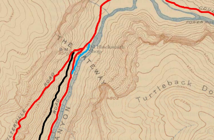
Here is a map of the route. Lots of older maps still show this as a road:


The bottom of the route is a half mile southwest of the bridge at the Cascades. The top of the route is at the Foresta dumpsters....if you can't see them, you are blind. The hike is 1.7 miles long, with a 1400 feet of vertical change. It should take about an hour, unless you have a photographer in the group.

Here is a distant view of the bottom of the route as seen from Wawona Road above the tunnel. May 2003. The big white patch at the bottom is white water in the Merced River, with Highway 140 alongside it. The power line is coming from the old Yosemite power house. It crosses the highway and then makes an abrupt left turn at the old road and disappears down river on its way to El Portal. The obvious road going diagonally up to the left is the old road. The huge boulder field is what ended the Coulterville Road., You can park a car on the highway next to the huge boulders, and climb the talus between them until you can spot the asphalt just above and to the west of the largest boulder.


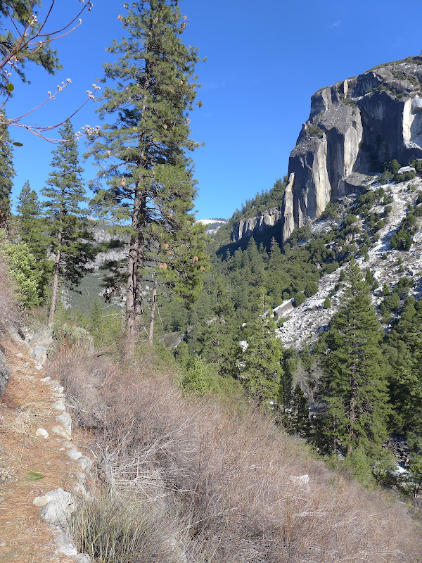
Here is a view taken on the upper part of the trail. April 2004. There is still asphalt under those pine needles.


The bottom boulder pile. April 2004. On that occasion, we descended from Foresta, so this was the end of the hike.


Edited 1 time(s). Last edit at 11/15/2012 05:32PM by wherever.
avatar Re: Old Coulterville Road (long)
June 23, 2010 09:21PM
Probably gonna be saying this a lot... so just get used to it...
Thanks!

btw.. if you take it the other direction... past the old barns and out of the park...
you'll eventually run into Little Nellie Falls. That falls is ... ok.. not great..
(you park your car by the barns. (Big Meadow).. and hike west then turn south)
Mikey and I did this in April 2009.

Foresta Falls is much more impressive. I'd recommend that way over Little Nellie.
(someone who perhaps didn't actually hike to these falls put it in a book
and now many unsuspecting souls head that way)
Re: Old Coulterville Road (long)
June 23, 2010 09:33PM
deleted obsolete link


Edited 1 time(s). Last edit at 11/16/2012 09:38PM by wherever.
avatar Re: Old Coulterville Road (long)
June 23, 2010 11:16PM
Billy and I did the Old Big Oak Flat road a couple of years ago starting at the trailhead right at the junction of Old Coulterville Road and 140. That piece of trail will lead you to the old roadbed where you turn right and head down to the valley. Tamarack Creek is a bit exciting to cross when flowing good like now.

Crossing Tamarack Creek


Bridalveil Fall from lookout


Greatest view of El Cap


Manworks


Tamarack Creek dry


Old Dude
Re: Old Coulterville Road (long)
June 23, 2010 11:59PM
Right. Thanks for the photos. But that creek crossing is not actually on the Old Big Oak Flat Road, which crosses Tamarack Creek on an excellent bridge at Tamarack Campground. I suspect that you started at the trailhead at route 41, the New Big Oak Flat Road, (marked on the map I posted as Foresta Turnoff) . That is an extension of the El Cap trail, which joins briefly with the old road to get across Cascade Creek, but does not cross Tamarack Creek where the old road did....

Maybe I'll post some details on the Old Big Oak Flat route next. Be assured, you did all the interesting parts of it.

**************************************************************************
You wrote: Billy and I did the Old Big Oak Flat road a couple of years ago starting at the trailhead right at the junction of Old Coulterville Road and 140. That piece of trail will lead you to the old roadbed where you turn right and head down to the valley. Tamarack Creek is a bit exciting to cross when flowing good like now.
avatar Re: Old Coulterville Road (long)
June 24, 2010 12:17AM
The first part of the route we took is indeed a trail. The old roadbed itself runs up through the Tamarack Flat campground and then down through the woods to Crane Flat paralleling the new road.


Old Dude


Edited 1 time(s). Last edit at 06/24/2010 12:19AM by mrcondron.
avatar Re: Old Coulterville Road (long)
February 06, 2011 10:26AM


Is this all they found after Olde Dude fell in??


The body betrays and the weather conspires, hopefully, not on the same day.
avatar Re: Old Coulterville Road (long)
February 06, 2011 02:44PM
Quote
Bee
Is this all they found after Olde Dude fell in??

So you noticed he has his belt buckle undone, eh?

To quote the Old Dude: "If I fell in I would have been ok, no problem".
To quote bill-e: "I would have gotten pictures of it."


Chick-on is looking at you!
avatar Re: Old Coulterville Road (long)
February 06, 2011 04:41PM
Quote
chick-on

So you noticed he has his belt buckle undone, eh?

I noticed and thought that we needed to give the pic a caption:

Olde Dude preparing for a swim!


The body betrays and the weather conspires, hopefully, not on the same day.
Re: Old Coulterville Road (long)
June 25, 2010 11:41PM
An additional comment about what caused the end of life for this road, even as a trail. From "Roadside Geology of Yosemite Valley" by Garry Hayes:

http://virtual.yosemite.cc.ca.us/ghayes/roadside.htm

1982 rockslide. Rocks on both sides of the highway are part of a 100,000 m3 rockfall which took place in April 1982. The slide closed the highway [Route 140] for several months, severed the sewer trunk line for Yosemite Valley, and caused the permanent closure of the old Coulterville Road which crossed the slope above highway (Wieczorek et al., 1992). The rockfall originated in jointed El Capitan Granite about 200 meters (600 ft) above the highway.

A better photo of this slide from the bottom is given by him here:

http://virtual.yosemite.cc.ca.us/ghayes/1982.htm
avatar Re: Old Coulterville Road (long)
February 06, 2011 09:52AM
Wherever,
Just did this trail yesterday. It used to be on the park map they give to you on entrance.
The road/trail as you describe is spot on (as usual).
IMO the trail is in pretty darn good shape for not being maintained.
Loved it! Maybe I'll post a pict. or two later.

Only complaint is now the Old Dude is gonna say "it's not on the park map I don't have to do it".


Chick-on is looking at you!
avatar Re: Old Coulterville Road (long)
February 06, 2011 09:54AM
WRONG!! Want to do it down to 140 and back.


Old Dude
Re: Old Coulterville Road (long)
November 15, 2012 06:01PM
This thread has drifted pretty far from the original topic. (see link) Here is a comment that is actually about the Old Coulterville Road.

We drove up to the park on Monday, and had a few hours to kill before we checked in at the Lodge. So we did the Old Coulterville Road, starting at the bottom. My wife wanted to get a look at the waterfall in McCauley Ranch up at Foresta, so she dropped us off at the boulder pile and drove up to Foresta. It had been more than eight years since we had done this hike, and we wanted to see if the washed out place had gotten any worse.

There was plenty of snow and cold air on the shady side of the valley. But it was sunny and warm where we were hiking. Which is one reason that I recommend this and the Old Big Oak Flat Road as hikes in the winter months. An alternative, of course, would be the Yosemite Falls Trail, which gets plenty of sunshine, but when we went up there on Wednesday it was too crowded for my taste. Except for some rock climbers on the cliff at the bottom, there was no one to be seen on Monday's hike...

Good news. The washed out place has not changed at all. It's still a non-problem, because although the trail is narrowed there, it is still asphalt. It is level and not slippery. In this picture, note the old armored telephone cable that ran under the old road.


Near the top of the hike, the road has a switchback that faces northeast. Here there was snow, but it was soft and melting. Not the shiny re-frozen stuff that you can't make a dent in.


This is still one of the best off-trail hikes for people who aren't sure about doing that sort of thing.


Edited 1 time(s). Last edit at 11/16/2012 10:03PM by wherever.
avatar Re: Old Coulterville Road (long)
November 16, 2012 06:34AM
Much like Old Wawona... the road is in exceptional shape all things considered.

Here's a shot looking east at the road and of Elephant Rock:


Chick-on is looking at you!
Re: Old Coulterville Road (long)
November 16, 2012 08:53AM
Of course, old Coulterville was still in use as an auto road (albeit an infrequently used one from what I understand) for nearly 50 years after Old Wawona was closed. As you head west of Big Meadow, I believe much of it is still in use as a fire or limited-access road. I've not walked the entire length of it (have yet to follow the section that turns slightly south towards Coulterville near the Mercer Grove trailhead) but it seems that it's only the bit that climbs the wall that is badly overgrown (and, despite the picture above, many stretches of it are VERY overgrown). Old Wawona, on the other hand, is much more consistently in bad shape. There ARE some moderately extended stretches where there is little or no obstruction but, especially once you get south of Inspiration Point and even more so once you enter the burn area south of Turtleback, it is rare to find a stretch of more than 200 or 300 feet which does not involve ducking under, around, over or through manzanita, downed trees, new growth and in some places (most notably wherever it crosses the current alignment), it takes real route-finding skills to determine where the road even was.

Still, these old roads are amongst my favorite walks in Yosemite. They instantly transport one back in time, you rarely see anyone else, there's often a sense of accomplishment simply in FINDING segments of it and the views are often spectacular (of course, you can say that about a LOT of places in the park).
avatar Re: Old Coulterville Road (long)
January 07, 2013 08:35PM
For those that love the 3D photos.

Here's the rock pile that smacked Old Coulterville Rd. Taken from El Portal Rd.
You can correlate this photo to the photos in the original post to get some scale
and your bearings if you don't know what you're looking at:
(hint... the big boulder with the curve... that's easily 25 ft. high)


The old road runs right next to the wall in the middle of the photo.


Chick-on is looking at you!
avatar Re: Old Coulterville Road (long)
January 17, 2013 10:08PM
Finally had a chance to look at this photo with my 3D glasses.

Incredible! A fantastic 3D photo of the rockslide.

.
Re: Old Coulterville Road (long)
November 16, 2012 12:49AM
In 1969, my Camp 1 neighbor and work partner Jack Kirk told me of a blacksmith shop that was located at the intersection of the Coulterville Road and the Arch Rock Road. I snooped around in the rock overhang and found charcoal, portions of rock-boring star drills and other garbage. Quite a bit of history around the Cascade area.
avatar Re: Old Coulterville Road (long)
January 14, 2013 07:21PM
In addition to The Old Coulterville Rd. there is a portion of The Old El Portal Rd.
in this area along with an old trail. The trail I haven't been able to find much info on at
all but it is in really decent shape. You can find it on a 1922 Yosemite Valley map
but by 1938 it has been removed from the map. I presume the trail is in decent shape
due to the power towers running next to it. Due to time constraints I didn't follow it to
it's terminus (I presume at Arch Rock entrance)... but it includes a lot of rock work and
is quite simple to follow. Due to the low elevation it's a bit of a bushwhack in places
and includes plenty of poison oak. If anyone follows it entirely or has done in the past
I'd appreciate your take on it. I would welcome any pruning of the PO too. smiling smiley
Trail on a map:

One of the nice views along the trail of Elephant Rock.


Chick-on is looking at you!
avatar Re: Old Coulterville Road (long)
January 16, 2013 03:20PM
nothing? really?


Chick-on is looking at you!
Re: Old Coulterville Road (long)
January 16, 2013 05:22PM
Quote
chick-on
nothing? really?

Not everyone is into poison-oak thrash-fests, you know... :-)
avatar Re: Old Coulterville Road (long)
January 16, 2013 06:29PM
I hear some people enjoy Coe, Ventana, and a bunch of other parks along the coast.
tongue sticking out smiley

Fair enough though. I will keep my crazy little projects to myself. I hear u.


Chick-on is looking at you!
avatar Re: Old Coulterville Road (long)
January 16, 2013 06:50PM
Some of us see PO as a burden one must bear for coastal or near coastal trips, and try to avoid it when possible.

Though I will admit that PO has an absolutely incredible fall color, I have a (sadly, film) picture of PO hanging off a rock along the beach at the Lost Coast in October (years ago). Incredible color.

(in any case, I'd be happy to read of, and see pictures of, the thrash-fest)
Re: Old Coulterville Road (long)
January 17, 2013 08:32AM
Quote
chick-on
nothing? really?

Hey, I'm sorry for not chiming in. Thanks for the post. Please don't take silence as a complete lack of interest. It's now on my list of things to look at. But I'm pretty allergic to poison oak. I wouldn't think of going up there while the leaves are missing, when it's impossible to figure out which bush is which species. I once went through a (leafless) winter thicket which I knew wasn't poison oak. But there were some strands of the stuff hidden in with the rest of it. My arms swelled up to twice their normal diameter.

Most power lines have at least some sort of access to the towers, left over from the tower construction, which they trim at least once a year. Are you suggesting otherwise, or that the old trail is crossed by these power line access roads?

I did spend some time looking at the map and at the photo. I'll bet some people never did see the tiny dotted line which is the old trail. And that some people thought that you had bushwhacked through the mass of brush at the center of the photo, instead of along the left edge of it.
avatar Re: Old Coulterville Road (long)
January 17, 2013 07:02PM
There's no power line access roads. Just the trail. The trail is in wonderful shape. Uh... mostly...
Maybe it's not obvious but the trail is on the left in the picture above with rockwork visible.
Here's two more:


What I mentioned about Old El Portal Rd I can show by this:

The cyan is the current road. The red to the left of that is Old Coulterville and the old alignment of El Portal Rd.

Poison Oak. Well... I've hiked extensively in Coe... and having gotten it so many times I figured I should learn what it looks like.
So I find that it can be identified by the twig alone. But it's always fun to avoid isn't it.

Anyway, enjoy.


Chick-on is looking at you!


Edited 2 time(s). Last edit at 01/18/2013 07:16AM by chick-on.
avatar Re: Old Coulterville Road (long)
January 17, 2013 10:06PM
Thanks for the info on this abandoned trail. I didn't comment earlier because I been quite busy this past week and haven't been able to keep up with all the threads. (This forum has seen a jump of activity this past week or two.)

Anyway, keep on posting these photos and maps. Love'em.

.
Sorry, only registered users may post in this forum.

Click here to login