After hiking past Red Peak and the Ottoway Lakes, I was considering, instead of continuing northwest back to Glacier Point, heading south at Merced Pass, east of Moraine Mountain and Givens Lake and then following west what I think is called Buck Creek Trail, which passes the Buck Camp Ranger Station, a trail that heads up to Royal Arches Lake, and Crescent Lake on the way west to Chilnualna Falls and Wawona. I haven't been able to find much information about people's experiences hiking this route and was wondering if anyone here has done so? If so, what are your thoughts on the route? Is it not frequently hiked for a reason?
My primary motivation for exploring this route over others is that I was looking for a way to get to the Mariposa Grove before leaving Yosemite, and, without a vehicle, this seemed like a potential option. It sounds like there are some interesting places along the way, including Royal Arches Lake, and Crescent Lake overlooking the South Fork Merced Canyon. Anyway, as I indicated, I haven't been able to get much information documenting the route. I would be grateful for any guidance offered.
Thanks
Frank

The Moon is Waxing Gibbous (60% of Full)
Re: Merced Pass to Chilnualna Falls
All posts are those of the individual authors and the owner
of this site does not endorse them. Content should be considered opinion
and not fact until verified independently.
|
Merced Pass to Chilnualna Falls July 13, 2010 10:39PM | Registered: 13 years ago Posts: 103 |
July 14, 2010 12:18PM | Registered: 15 years ago Posts: 1,876 |
July 14, 2010 08:54PM | Moderator Registered: 15 years ago Posts: 1,918 |
Hi Frank.
Not sure how much I will help you since I think that you should hike ALL the trails.
Then go off the trail and explore.

Actually everywhere that I've been I'm always surprised at what little nuggets there are
all over. Even the trail S of the Givens Lake/ Moraine meadow one. I wasn't really
expecting much but as I was hiking on it I was just saying "dang, this is really nice...
I gotta get the Old Dude on this baby".
I really really loved Givens Lake on account there is just a great view of Givens Meadow.
And a short stroll will take you up to the Buena Vista Crest with superb views of
Moraine Mountain on one side and the Clark Range ... on the other.
There will more than likely be flowers still on the hill after Buck Camp also.
As far as the lakes... Royal Arch I've only been to once but is beautiful.
Definitely need to go back there.
Johnson has decent fishing but like many of the lakes (Givens, Grouse,
Minnow, Johnson, Crescent, a number of Chil Lakes) is mainly surrounded by woods.
The south side has nice camping, and if memory serves me, the best views
down canyon (although don't expect too much).
Crescent is fast becoming a meadow. Maybe with the large snowpack it is back some.
Only been there twice and it's been awhile so... dunno. Grouse you will probably
walk right by unless you are really on the lookout for.
Buena Vista Lake is very very nice. To see the nicest Chil Lake you have to go off the trail.
If you want a recommended route then I guess I'd say stop at Givens, then Royal Arch,
then Buena Vista, then head down to Chilnualna Falls.
Not sure how much I will help you since I think that you should hike ALL the trails.
Then go off the trail and explore.
Actually everywhere that I've been I'm always surprised at what little nuggets there are
all over. Even the trail S of the Givens Lake/ Moraine meadow one. I wasn't really
expecting much but as I was hiking on it I was just saying "dang, this is really nice...
I gotta get the Old Dude on this baby".
I really really loved Givens Lake on account there is just a great view of Givens Meadow.
And a short stroll will take you up to the Buena Vista Crest with superb views of
Moraine Mountain on one side and the Clark Range ... on the other.
There will more than likely be flowers still on the hill after Buck Camp also.
As far as the lakes... Royal Arch I've only been to once but is beautiful.
Definitely need to go back there.
Johnson has decent fishing but like many of the lakes (Givens, Grouse,
Minnow, Johnson, Crescent, a number of Chil Lakes) is mainly surrounded by woods.
The south side has nice camping, and if memory serves me, the best views
down canyon (although don't expect too much).
Crescent is fast becoming a meadow. Maybe with the large snowpack it is back some.
Only been there twice and it's been awhile so... dunno. Grouse you will probably
walk right by unless you are really on the lookout for.
Buena Vista Lake is very very nice. To see the nicest Chil Lake you have to go off the trail.
If you want a recommended route then I guess I'd say stop at Givens, then Royal Arch,
then Buena Vista, then head down to Chilnualna Falls.
July 14, 2010 08:56PM | Moderator Registered: 15 years ago Posts: 1,918 |
July 14, 2010 08:57PM | Moderator Registered: 15 years ago Posts: 1,918 |
July 14, 2010 09:00PM | Moderator Registered: 15 years ago Posts: 1,918 |
July 14, 2010 09:20PM | Moderator Registered: 15 years ago Posts: 1,918 |
A few other notes... I only remember flowers and whining coming west up from Buck Camp.
(we spent the night at Givens Lake)
I wanted to go to Royal Arch but got outvoted about 20,000 to 1 by GW and The Old Dude.
(it's more uphill to Royal Arch... ) So we ended up at Johnson.
Looks like a nice view from 8845T W of Crescent. When I do it next I'll prob. just x all
the way from Crescent to Wawona Dome.
Minnow used to have big fish in it... but those are probably all dead by now.
Minnow is similar to Royal Arch. Nice granite next to it... and I doubt anyone goes there
since it's off trail.
Don't have any pix of that though. Didn't used to take a camera.
Do have some of Buena Vista Lake and from the Peak if you want to see those.
I just confused you more. ???
July 14, 2010 09:23PM | Moderator Registered: 15 years ago Posts: 1,918 |
|
Re: Merced Pass to Chilnualna Falls July 14, 2010 09:47PM | Registered: 13 years ago Posts: 103 |
Thanks Bill-e-g! Your descriptions were helpful and the pictures a surprising bonus. Crescent was not quite what I had imagined, based on guidebook descriptions of that lake. I like your suggested route, swinging north and then west past Royal Arches, Buena Vista and Chilnualna Lakes. Do you think it is possible (though perhaps not desirable if one wanted to linger) to hike the distance from Merced Pass to Chilnualna Falls in a couple days?
On a different note, if one finds oneself in Wawona, do you know of anywhere a backpacker could camp for one night around there without going back up to Chilnualna Falls? And, perhaps obviating the need to camp overnight there, do you know of any way to get back to the Valley in the afternoon / evening (will not have a car). It seems there is a shuttle, but that it is designed to take people from Wawona to the Valley for the day and then return them, so the only shuttle going that way leaves at 8:30 am. One thought, was that employees might go back to the Valley in the evening and maybe we could give them some money to give us a ride, but don't really know about that.
Thanks again for the advice (and the pictures!) about the hiking route.
frank
July 15, 2010 07:08AM | Moderator Registered: 15 years ago Posts: 1,918 |
Upper Merced Pass Lake to the top of Chilnualna Fall is right at about 20 miles via
Royal Arch and Buena Vista Lakes. (taking the southern trail to the fall)
If you stay at Lower Ottoway (when you doing this anyway?) (you know Red Peak Pass
west side gonna be flush with snow for quite a bit yet if that scares you)
(I assume you're going up the Merced past Merced/Washburn.... )
(if it's imminent then you best find out what the pass is really like and if you
want to tackle it)
.. anyway,
Lower Ottoway to Givens (there used to be trail to it) (still is?) is about 8.
Givens to Buena Vista Lake is about 8.
Buena Vista to top of Fall is about 8.
If I were planning it with others I would recommend the 8/8/8 option to give time to explore.
I showed the pictures of Buena Vista Crest... now I wanna go back there soon.
I liked that location on the Crest better than Buena Vista Peak.
I gotta see what Crescent looks like now (been too long)... Plus Old Dude has some trails to
mark off in that area.
As for camping below Chilnualna Fall. Not sure about that. I'm just looking at the NG map
and it doesn't say you can't camp off the trail towards Mount Savage...
Maybe someone else will help you on the shuttles. I end up just looking at the nps site.
From what you said it sounds like you already did.
Have fun... let us know what you did and how it went.
July 15, 2010 07:10AM | Moderator Registered: 15 years ago Posts: 1,918 |
Crap. east/west... sigh. I meant RPP EAST Side will be flush with snow.
The trail up the west clears earlier... but is steeper and has some
great stonework that... if snowbound... you would prob. want an ice axe to
conquer. Too bad the Sentinel Dome camera isn't pointed a little to the
south so can see the Clark Range.
The trail up the west clears earlier... but is steeper and has some
great stonework that... if snowbound... you would prob. want an ice axe to
conquer. Too bad the Sentinel Dome camera isn't pointed a little to the
south so can see the Clark Range.
August 24, 2010 08:05AM | Moderator Registered: 15 years ago Posts: 1,918 |
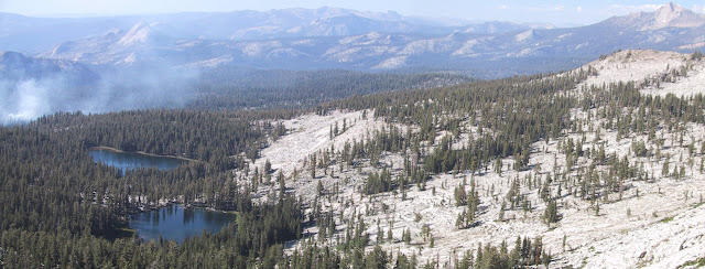
Old Dude and I just hiked in this area... and IMO it's even better than what I remembered.
Saw a total of 3 people at Crescent Lake and 2 people at Ostrander in the 3 days.
We started at Westfall Meadow and went to Buena Vista Lake then x over to Ostrander and
out Bridalveil campground.
OD Mike went via Chil Lakes trail up to BV Lake. I went Via Grouse/Crescent/Johnson/Royal Arch/
Mount Bruce/BV Crest t BV Lake.
Went on the ridge S of Grouse (again, there was no trail to Grouse that I saw... and they
rerouted the trail a bit off of what is on my GPS). Some really great views of Turlock from
up on the ridge. The ridge from Grouse to Crescent is open ... you can see the
mountains in the southern Sierra from there too... really nice.
The whole area is highly underrated IMO. There is a lot of granite and exfoliation going on.
The lakes of Johnson, Grouse, Minnow (didn't visit this time), and Royal Arch all have
the same characteristic of a nearby granite wall ... some closer than others...
Grouse and Johnson are predomin surrounded by forest... go a little ways away and
there is granite to play on. The outlets of Crescent and Johnson both provide
nice views to the south.
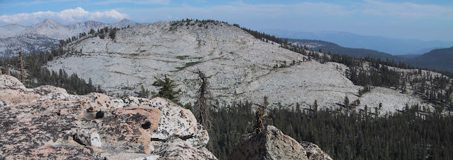
Buena Vista Crest views are spectacular. If you have the gumption diss the trail
(I find the trails are very often not placed for scenic value... but for ease of travel)
and head from Royal Arch up to Mt. Bruce. The travel along BV Crest is just a joy.
Frank, did you head out that way ever?
Saw a total of 3 people at Crescent Lake and 2 people at Ostrander in the 3 days.
We started at Westfall Meadow and went to Buena Vista Lake then x over to Ostrander and
out Bridalveil campground.
OD Mike went via Chil Lakes trail up to BV Lake. I went Via Grouse/Crescent/Johnson/Royal Arch/
Mount Bruce/BV Crest t BV Lake.
Went on the ridge S of Grouse (again, there was no trail to Grouse that I saw... and they
rerouted the trail a bit off of what is on my GPS). Some really great views of Turlock from
up on the ridge. The ridge from Grouse to Crescent is open ... you can see the
mountains in the southern Sierra from there too... really nice.
The whole area is highly underrated IMO. There is a lot of granite and exfoliation going on.
The lakes of Johnson, Grouse, Minnow (didn't visit this time), and Royal Arch all have
the same characteristic of a nearby granite wall ... some closer than others...
Grouse and Johnson are predomin surrounded by forest... go a little ways away and
there is granite to play on. The outlets of Crescent and Johnson both provide
nice views to the south.
Buena Vista Crest views are spectacular. If you have the gumption diss the trail
(I find the trails are very often not placed for scenic value... but for ease of travel)
and head from Royal Arch up to Mt. Bruce. The travel along BV Crest is just a joy.
Frank, did you head out that way ever?
August 24, 2010 08:19AM | Moderator Registered: 15 years ago Posts: 1,918 |
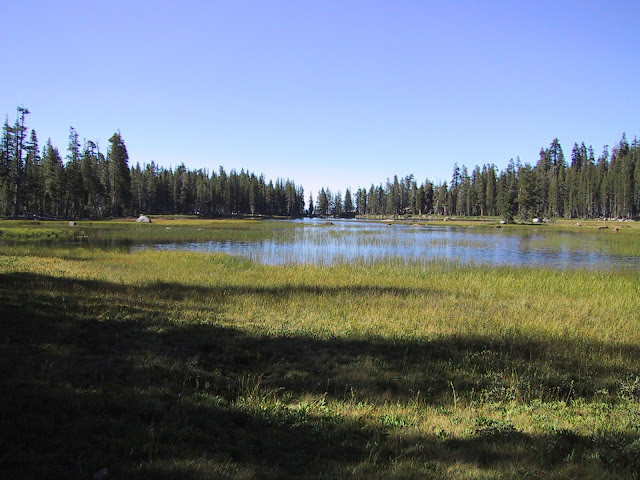
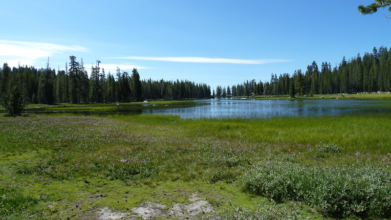
One other comment: I actually find Crescent very pretty and incredibly interesting.
Many of the lakes fill way up and then drain thru the summer and fall.
They can drop a couple of feet... You can sometimes see rocks in the lake with
pollen rings to give you an idea ... Crescent really is no different. Right now
it is more full than what the picture above showed... and it was easily 1 foot
higher earlier in the year... so .. this is a lake I'd like to see very early in the
year and very late.
Here Crescent is now (Aug 21):
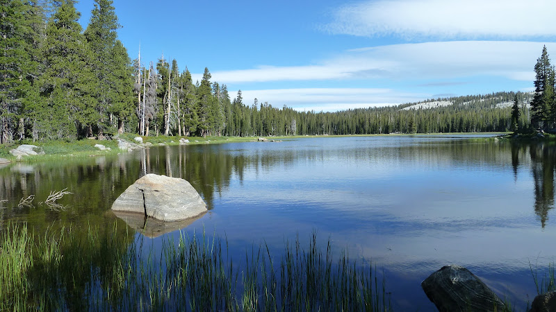
Here it is from the outlet. (note the pollen):
Many of the lakes fill way up and then drain thru the summer and fall.
They can drop a couple of feet... You can sometimes see rocks in the lake with
pollen rings to give you an idea ... Crescent really is no different. Right now
it is more full than what the picture above showed... and it was easily 1 foot
higher earlier in the year... so .. this is a lake I'd like to see very early in the
year and very late.
Here Crescent is now (Aug 21):
Here it is from the outlet. (note the pollen):
August 30, 2010 08:38PM | Moderator Registered: 15 years ago Posts: 1,918 |
|
Re: Merced Pass to Chilnualna Falls August 31, 2010 01:06PM | Registered: 13 years ago Posts: 1 |
August 25, 2010 06:03AM | Moderator Registered: 15 years ago Posts: 1,918 |
|
Re: Merced Pass to Chilnualna Falls August 31, 2010 09:24PM | Registered: 13 years ago Posts: 103 |
Hi Bill,
Sorry for the delay in responding. I actually have been intending to summarize my trip on here, but have been quite busy since getting back, but I will get to that soon hopefully. Briefly, My nephews (17 and 15) and I were in Yosemite from July 18 through July 30. Our itenirary:
July 18: Arrived in Valley midday and after tending to various errands hiked up the mist trail to Nevada Falls and back.
July 19: Took Tour bus up to Glacier point, the site of our trailhead. While there we hiked up to Sentinel dome before heading in along Panorama trail, then heading south along the base of Mt Star King for our required first night in the Illilouette drainage.
July 20: Back to Panorama and onward along John Muir to Little Yosemite Valley where we decided we'd spend the night. We left our stuff and hiked up to Half Dome and back.
July 21: Left LYV and headed up the Merced Canyon to Merced Lake where we spent the night in the backpackers camp. (This was a beautiful hike as the water volume was still very nice and the water was alongside us for most of the hike).
July 22: Merced Lake to Vogelsang along the Fletcher route. I had planned to do the Lewis route but the first few days were catching up with me and I was not viewing the considerable additional elevation and distance favorably at that point. Still want to do it though. Even on Fletcher, lots of going UP. My pack was heavier than I'd have liked. At Vogelsang: Mosquitos!
July 23: Vogelsang to Tuolumne Meadows via Lyell Canyon. Again, this was a very enjoyable hike as the terrain encountered was quite varied and beautiful. We pressed hard once in Lyell Canyon as we needed to get to the Post Office to pick up more food before it closed. We arrived with 15 minutes to spare. TM GRILL: Need I say more. Stayed in backpackers camp, where a camper who slept outside that night was awakened in the morning with a nice rub on the nose by the nose of a bear cub, with mama watching carefully a few steps away.
July 24: TM to Long Meadow, just north of Sunrise. Got a late start, encountered biblical plagues of mosquitoes at the lower Cathedral Lake, as well as a thunderstorm/rain, which alternated with hail on and off for about an hour.
July 25: Long Meadow to granite slabs south of Washburn Lake via trail that branches off from JM just north of Sunrise.
July 26: Continued on south and then west towards Red Peak, camping at Red Devil Lake, only it wasn't Red Devil Lake. We headed off trail towards the lake and soon my nephews spotted water which we headed towards thinking it was RDL. (Mosquitoes ). The next morning, checking my GPS, I discovered we were not at Red Devil Lake, but instead at some puddle east of there.
July 27: Across Red Peak Pass, where we lost the trail a few times because of snow (it's much easier looking down to piece the trail pieces together than looking up). We continued on, past Ottoway Lakes to the Upper Merced Lake, where we had an outstanding campsite on a chunk of granite up high looking down upon the edge of the lake. Took a swim in the lake -- very nice.
July 28: Headed south across Merced Pass then west past Buck Camp Ranger station, Johnson Lake, Grouse Lake, Crescent Lake ultimately camping near Chilnualna Falls. On this day we were pushing hard as we wanted to get to Wawona the next day. I had a moment when my nephews were somewhat ahead of me on the trail, I knew a junction was coming up near Chilnualna, and I needed to take the left trail. I stopped to check my GPS, which indicated that I was on the wrong trail. It was about an hour before total darkness and I panicked a bit as I thought maybe I had missed the junction and my nephews were perhaps somewhere else. This led to me leaving the trail trying to find the correct trail, to no avail, back tracking a couple times, etc. Eventually I decided to continue on original course where I eventually got a response to my calling for my nephews, who were also looking for me. I had been only a short distance from the junction when all this started. The problem I later discovered (other than not trusting myself), was that the GPS was using a map that was WRONG. I thought I was looking at USGS quads, but at that resolution, it was displaying the Delorme TOPO map. In this area it was completely wrong about the trails. Had I been actually looking at the USGS quads, this would never have happened. Again, here we had an awesome campsite (which I arrived at about 10 minutes before darkness) overlooking the lower Wawona area.
July 29: We went to Chilnualna Falls and headed down the long (LONG) switchbacks, arrived in Wawona, continued to the Wawona Store, ATE (!), boarded bus to Mariposa Grove and explored that for 3 hours or so. This had been the prime motivation for the final choice of trails on last day or two. We hitchhiked back to the Valley, enjoyed dinner in Curry Village, spent the night in the backpackers camp.
July 30, exited park on YARTS, Amtrak to Sacramento, and back home.
Hiking distance: 120 miles. climbing elevation: 35,000 feet; Descending elevation: 40,000 (elevations includes mist trail and sentinel dome day hikes).
Because we were moving quickly through the south part of the park to Wawona, we didn't get to really stop and look at things much. I'd love to do the hike you described above that goes by Buena Vista Lake, Royal Arches, etc.
As I was hiking past Buck Camp Rangers Station towards the junction to Royal Arches, I recalled a statement you made to me in one of your posts about the other people in your group protesting wildly at the proposition of continuing uphill to Royal Arches. Now I know why. The hike West of the Rangers station seems like an endless climb upwards.
Thanks so much for your advice. When I return to Yosemite, I plan to linger at some places that I moved on through this time.
It was a great trip. It was the first time ever hiking of any kind for my nephews. Yep, it was a big trip for the first time, but they loved it, and are hooked. They are now back in school, but dreaming of Yosemite. That was the point. I didn't want them to wait until they were in their 40's before they saw the place like for me. Hopefully this will be the start for them of a new and enriching part of their life.
Thanks again.
Frank
September 01, 2010 06:57AM | Moderator Registered: 15 years ago Posts: 1,918 |
|
Re: Merced Pass to Chilnualna Falls September 01, 2010 09:48AM | Registered: 13 years ago Posts: 10 |
It is great to hear about trips like yours. It sounds like it was truly special.
I rarely post, but thoroughly enjoy reading what everyone here has to say about Yosemite. My trip with the family to Tuolomne in late June was nixed due to the late snows earlier this year. Maybe next year if time and conditions allow.
Thanks for the wonderful summary.
I rarely post, but thoroughly enjoy reading what everyone here has to say about Yosemite. My trip with the family to Tuolomne in late June was nixed due to the late snows earlier this year. Maybe next year if time and conditions allow.
Thanks for the wonderful summary.
September 01, 2010 04:48PM | Registered: 15 years ago Posts: 1,876 |

|
Re: Merced Pass to Chilnualna Falls September 01, 2010 06:08PM | Registered: 15 years ago Posts: 619 |
|
Re: Merced Pass to Chilnualna Falls September 01, 2010 08:25PM | Registered: 14 years ago Posts: 923 |
Quote
The Other Tom
Quote
tomdisco
Frank,
Suggestion: Ditch the GPS map and carry a real one like Nat'l Geo Trails Illustrated.
Or a Tom Harrison map
I usually get Harrisons to take with me. The Nat Geo are too HUGE (covers too wide an area, not nearly so useful to navigate with) and they have incorrect mileages. A Harrison map of about 1:24 or 1:30 will be much more useful for a compass user than a NG 1:80. (Some of the Harrisons are also HUGE but I have found they frequently have ones for sub-units of the same area, like Rae Lakes Loop instead of the Mt Whitney High Country map.
I use a Nat Geo to plan out a whole hike, Harrisons to navigate with, and a GPS to locate a UTM coordinate on the map, punch it in, and let it direct me there. Trails on GPS maps are frequently fictitious as a buddy and I found out the HARD WAY. The JMT has changed course on some legs since the USGS maps were written....
|
Re: Merced Pass to Chilnualna Falls September 01, 2010 07:49PM | Registered: 13 years ago Posts: 103 |
I had the national geographic maps, and paper quads for some areas I hiked through. I was using GPS primarily for tracking, and as a way to quickly confirm my location. This worked well generally, except for 2-3 areas where the Delorme map veered briefly from reality. The USGS quads on the GPS though were accurate, and had I been looking at those at the time (I mistakenly thought I was), all would have been clear. Also, had my nephews been with me, it wouldn't have mattered to me. It was that separation and moment of panic with encroaching darkness that rattled me.
I have never had a Tom Harrison map, but I have recently read things by people who were advocating them. Do they have some particular advantage over the Nat'l Geo maps and USGS quads?
I have never had a Tom Harrison map, but I have recently read things by people who were advocating them. Do they have some particular advantage over the Nat'l Geo maps and USGS quads?
|
Re: Merced Pass to Chilnualna Falls September 01, 2010 08:31PM | Registered: 14 years ago Posts: 923 |
Quote
Frank
I have never had a Tom Harrison map, but I have recently read things by people who were advocating them. Do they have some particular advantage over the Nat'l Geo maps and USGS quads?
A career hiker I know met Tom Harrison on the trail once, with his measuring wheel. I have walked trails with GPS and found that Harrison maps tend to be more accurate in measuring out the miles.
Also, as I mentioned above, a map of better resolution (1:24) will allow you to navigate more precisely - I can triangulate my position, find a UTM coordinate, or plot out a route more accurately and precisely on the Harrisons that aren't suffering the same "whole darn park" problem as the Nat Geo maps. If all you do is follow trails the Nat Geo will be okay, you may hike a little longer or shorter some places than the map actually shows.
I also find the colors on the Harrison maps easier on my farsighted eyes - sometimes there is not enough contrast on the Nat Geo maps for me to pick out what details they do have on them.
September 01, 2010 09:10PM | Moderator Registered: 15 years ago Posts: 1,918 |
September 02, 2010 03:58AM | Admin Registered: 15 years ago Posts: 17,050 |
September 02, 2010 06:36AM | Moderator Registered: 15 years ago Posts: 1,918 |
Quote
eeek
Quote
bill-e-g
Personally I very frequently only bring a GPS.
If you know how to use it it's got everything you need.
Until it breaks or the batteries die.
Maps are good until you lose them.
(I've found plenty of maps sitting on rocks... )
To each is own... but IMO, yes, it's a HUGE area... but...
if you know which way is up it's fairly simple to find a trail.
<knock on granite>
|
Re: Merced Pass to Chilnualna Falls September 02, 2010 07:19AM | Registered: 14 years ago Posts: 923 |
Do you know how many times the GPS has been wrong? We use them constantly for Search and Rescue. They send us waayayyyyayyayy off sometimes. Start out a little off, in an hour you are three miles off course. Why we have a map guy who gives us printed, focused-on-the-region maps every mission, and an orienteering compass is on our list of MUST HAVES. They want us to get where we are supposed to go. Don't miss the helicopter pickup! You were on the wrong bald? Oh, sorry, didn't see you FOUR MILES OVER THERE. And we're not wasting the fuel to come get you, just enough to get back to Fresno, sorry. Hope you brought those Clif bars. Back in a while if the weather's still good.
If you are near large deposits of metal, large metal objects, or stray magnetic fields, the GPS can get wacky. If you are not calibrating the compass regularly they get wacky. If there are sunspots they get wacky. Sometimes they just go nuts and want you to march a mile the wrong direction. GPS units use old maps with trails that no longer exist - I have been standing ON the location according to the GPS and see weeds, rocks, but no indication of the trail. These things put the trail fifteen feet up/down the hill from where you are. They lose the satellite and you are screwed if you have no map. And we have the really good ones, not just the cheapo hunnerd dollar models.
Every method has its limitations, but maps don't break, freeze the batteries to useless, or randomly short out. And you don't swear up and down if you leave the map sitting on a rock! I had to go back and grid search a field of manzanita TWICE when a gps fell out of its pocket (where it was velcro'd, bungeed and otherwise fastened) and hung up in the brambles - if it had been a map I would not have cried about it, sweat about it, swore about it, because maps don't cost $500!
Use a map for god's sake, and the mrs. Cheap insurance.
September 02, 2010 07:47AM | Moderator Registered: 15 years ago Posts: 1,918 |
As I said... to each is own...
As for GPS being wrong and not having the correct trail...
once you know the limitations it's no big deal...
I know where I am almost all the time... look at the GPS... and
I know it's wrong... so turn it off... turn it back on ... and
there I am... where I knew I was.
As for the trails on the maps w/i the unit... that all depends where u
are too... some trails have moved some... some are just wrong...
Do your homework beforehand... or if you haven't been in an area
before then carry maps too. (which I do.. )
blah blah blah
It goes for any trip in the wilderness... be prepared. be safe.
Have fun
I liken this to the Half Dome discussion about what you need to get up it.
I used a total of 1 1/2 litre of water going up Clouds/ 1/4 domes / 1/2 /
and Lib. Cap... so.. as eeek says... YMMV
|
Re: Merced Pass to Chilnualna Falls September 02, 2010 08:11AM | Registered: 14 years ago Posts: 923 |
Quote
bill-e-g
As I said... to each is own........
It goes for any trip in the wilderness... be prepared. be safe.
Have fun
I liken this to the Half Dome discussion about what you need to get up it.
I used a total of 1 1/2 litre of water going up Clouds/ 1/4 domes / 1/2 /
and Lib. Cap... so.. as eeek says... YMMV
We have had to rescue people who rely exclusively on GPS units.
I felt I needed to mention it, not for your sake - it is a HUGE problem when people begin to rely solely on a GPS for everything navigation. I don't doubt you know the way around the mountains better than anyone... but most people are not you. Most people don't ever learn how to use a GPS and believe they are a replacement for maps. They are NOT. They are a tool, very useful, but a GPS will not tell anyone in plain English what they should do or where they are. People think it DOES. It only makes SAR work harder to have people heading out with a GPS and thinking it will tell them what to do. People already do that all the time - I've found people standing there scratching their heads over the GPS they borrowed from Uncle Timmy without bothering to read instructions or asking how to use it.
I'm not lecturing at you, bill - it's just not good to suggest to any large group of people that they do as you do, because they are not all bill, master of the granite-strewn mountains. So I felt I needed to put in a word for actual navigation skills and NOT RELYING ON ELECTRONICS to keep you safe and get you out of a jam. The best way to not be lost is PAY ATTENTION to where you are from the trailhead out, PAY ATTENTION to the position of the sun, the miles you hike, how long you have been out there, PAY ATTENTION some more to the position of the land features around you - don't just get yourself lost and look at the magic GPS only when you're lost. It doesn't work that way.
I'm with you, bill - I never looked at maps! I rarely do when out hiking for pleasure. I've always navigated by landmarks and paid attention to things like the lay of the land. I can look at slopes and benches and such and walk straight to the nearest lake, I know the directions of the sun and can go off the position of it. I hardly bother with a compass. But I'm never going to suggest it or even mention it in open forums because I don't want people to use me for an example. Other people don't go out as much as I do. They don't practice. So I'm not going to just shrug and take it so easy - they need a map more than you do. This stuff takes a lot of practice. I tried to help some noobs recently with just general awareness - it comes real hard to them, we ended up with the map out and they could not even place a prominent peak on the paper. I keep getting reminded that not everyone has a good sense of direction, or any sense at all, and I end up teaching them how to do things that seem to me very basic.
The thought of someone following my example and getting lost just sets my teeth on edge. So sorry if I sound like I am coming down on you - I worry about the noobs because I go look for the remains of the ones who vanish without a trace and leave their families wondering where they are. We look every year for a man who disappeared in Dinkey. No trace yet.
Edited 2 time(s). Last edit at 09/02/2010 08:33AM by AlmostThere.
September 02, 2010 10:09AM | Moderator Registered: 15 years ago Posts: 1,876 |
Quote
AlmostThere
We look every year for a man who disappeared in Dinkey. No trace yet.
On a similar note, I seem to recall that a ranger disappeared in the Kings Canyon backcountry sometime around the mid-1990s (if memory serves correctly on the timeframe). Does anyone know if any trace of him was ever found?
September 02, 2010 12:29PM | Registered: 15 years ago Posts: 2,321 |
Probably this:
Filed: 07/19/2001
By BRYAN SWAIM, Californian staff writer e-mail: bswaim@bakersfield.com
The remains of a park ranger who disappeared five years ago while on patrol in the Sequoia and Kings Canyon national parks apparently were found Sunday, parks officials said. Randy Morgenson, 54, was last heard from on July 20, 1996, before setting off on a back-country patrol. A note was found July 21 at his duty station saying he was expecting to be gone three to four days. A search was initiated for him July 25 and at its peak involved 90 people, five helicopters, and eight dog teams. No clues were found, and the search was scaled back Aug. 2, 1996.
Almost five years to the day he was last seen, four off-duty trail crew members found remains and a leather hiking boot in a stream drainage northeast of Window Peak, a remote and trailless area of Kings Canyon National Park. A pack and some equipment were also found in the same area.
Park rangers and two teams of search dogs were flown to the site Monday and focused the search on the stretch of stream drainage approximately a quarter-mile north of a large lake east of Window Peak. Searchers located additional remains, a hand-held radio, and a park ranger uniform with a badge and Morgenson's name tag on it.
Remains were sent to the Fresno County coroner for identification against dental records, and results should be back within seven to 10 days. It is believed that Morgenson died from an accidental fall while attempting to cross the stream.
The location where the remains were recovered was searched by rangers multiple times in 1996. It is likely Morgenson's body was not seen because of the high amount of runoff in the stream that summer.
Kris Fister, spokeswoman for Sequoia and Kings national parks, said the 1996 search was difficult emotionally for the parks staff, and although the dental records haven't yet confirmed the remains are Morgenson's, the findings have brought some closure to those who knew him. "We're 99.9 percent certain the remains belong to Randy," she said.
Back country refers to the wild terrain in the sequoias accessible only by foot. Morgenson served as a back-country ranger in Sequoia and Kings Canyon for 28 years. He lived in Arizona and worked at the park during the summer.
Old Dude
September 02, 2010 12:43PM | Moderator Registered: 15 years ago Posts: 1,876 |
Quote
mrcondron
Probably this:
Filed: 07/19/2001....
Thanks Mike.
Nice to know that they eventually found him.
Footnote to those familiar with the Rae Lakes Loop: the spot where they found him is about a mile N of the Woods Creek suspension bridge crossing.
Edited 1 time(s). Last edit at 09/02/2010 12:56PM by szalkowski.
September 02, 2010 04:50PM | Moderator Registered: 15 years ago Posts: 1,918 |
September 03, 2010 12:39PM | Registered: 15 years ago Posts: 1,876 |
Quote
bill-e-g
No worries... lecture all you like.
I love using a GPS, that's all. Even a paper map won't do you much good if you can't read it,
haven't a clue where you are... or have a crap map.
So kids...
"carry a map, compass, and know how to use them"
Have fun
Aside from the hiking world I've always been dumbfounded how many people never learned how to read a map or have any understanding whatsoever of compass headings. I often give people local directions and have to avoid using such complicated words such as North, South, East, and West because it draws blank stares. There are many people who totally lack the spatial perception of North being the top of the page, South being the bottom, etc. since these directions mean nothing to them to begin with. These are the same folks who can not pick out Maine, Florida or Califonia on a map of the U.S. unless they know them by their shape. As a kid I had one of those puzzles of the U.S. with separate pieces for most of the states with their capital cities on them. I played with it so many times I could do it blindfolded. People don't learn this stuff like that anymore. I don't even know if they still teach geography in middle schools. O.K., I'm done ranting. Those of us who can read maps are special,---I think.
September 02, 2010 02:25PM | Registered: 15 years ago Posts: 670 |
September 02, 2010 05:34PM | Moderator Registered: 15 years ago Posts: 1,876 |
Not only found, but memorialized in a book.
Somehow the whole recovery story ended up below my radar.
Thanks for the links Joel. In browsing around among them, I managed to wander over to this website thread that people may find an interesting read:
http://www.highsierratopix.com/community/viewtopic.php?t=469
Its timeframe is back in 2006 when the book was just hitting the bookstores. The thread was started by and contains several posts by another backcountry ranger who gives some valuable insights worth contemplating.
Edited 1 time(s). Last edit at 09/02/2010 05:36PM by szalkowski.
September 02, 2010 06:19PM | Moderator Registered: 15 years ago Posts: 1,918 |
September 06, 2010 09:20AM | Moderator Registered: 15 years ago Posts: 1,918 |
|
Re: Merced Pass to Chilnualna Falls September 07, 2010 06:15PM | Registered: 13 years ago Posts: 103 |
September 07, 2010 08:40PM | Moderator Registered: 15 years ago Posts: 1,918 |
Quote
Frank
What sign? I'm guessing you would be referring to a sign that said "Merced Pass". If so, I did not see any sign there when I passed over it on July 29th.
Yup. It was there in 2006... There used to be one atop Red Peak but that one has been gone for a really long time too.
I saw no signs of it at all this time thru (Sat.).
2006:
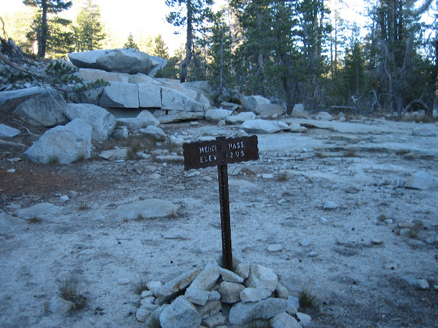
Pretty sure the trail didn't move over... took pict. there but didn't get the exact same angle of
the dangle so just wasn't 100% sure if I just stupidly somehow walked by it...
Thx
Sorry, only registered users may post in this forum.

