But having done that, you are there in Yosemite with a bike and nowhere else to go with it, unless you want to share the highway with terrified amateur drivers of wide pickups and RVs. I bike all the time at home, but I'm not crazy enough to do that on any Yosemite highway. We were up there this last week, and while driving on Tioga Road uphill from Crane Flat, we got to witness a string of bicycles being passed on blind corners by nitwits with no uphill acceleration and a foolish belief that there would be no oncoming traffic. It was just a matter of time until one of these giant RVs met its mate coming the other way, and pushed a bicyclist right off the road. Or worse. Biking in traffic is not for me.
Except for that bike path, bicycles in the park are restricted to the roads. Luckily, there are roads in the park that are absolutely not highways. I can talk about five of these, two of which are a terrific ride on almost any bike with fat tires. None of them are suitable for road bikes or small children. None of them are flat.
Ride #1 Foresta Road from Foresta to Crane Flat
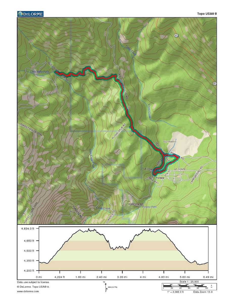
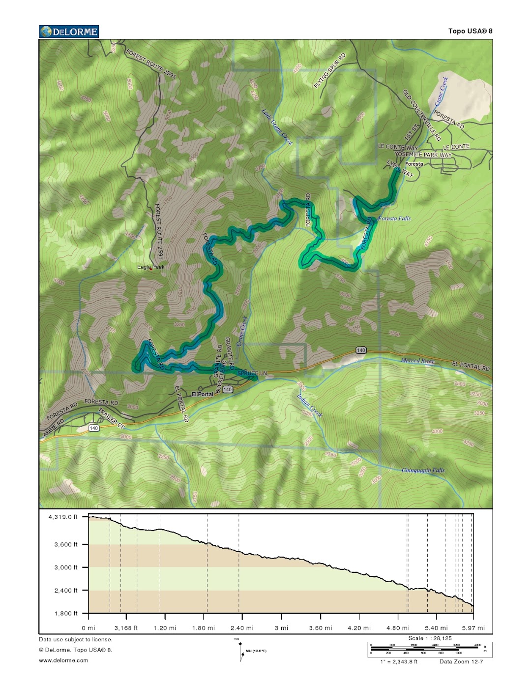
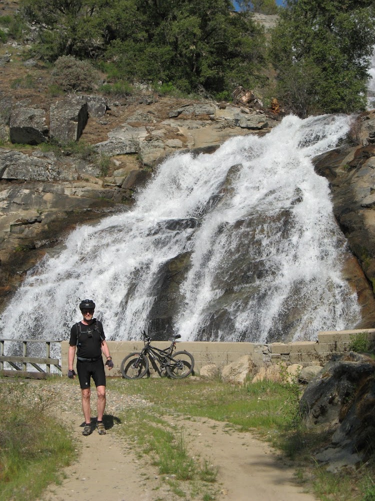
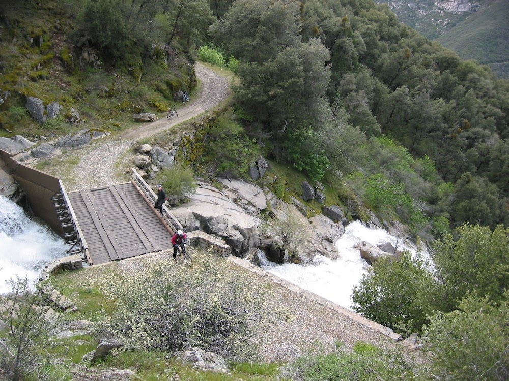
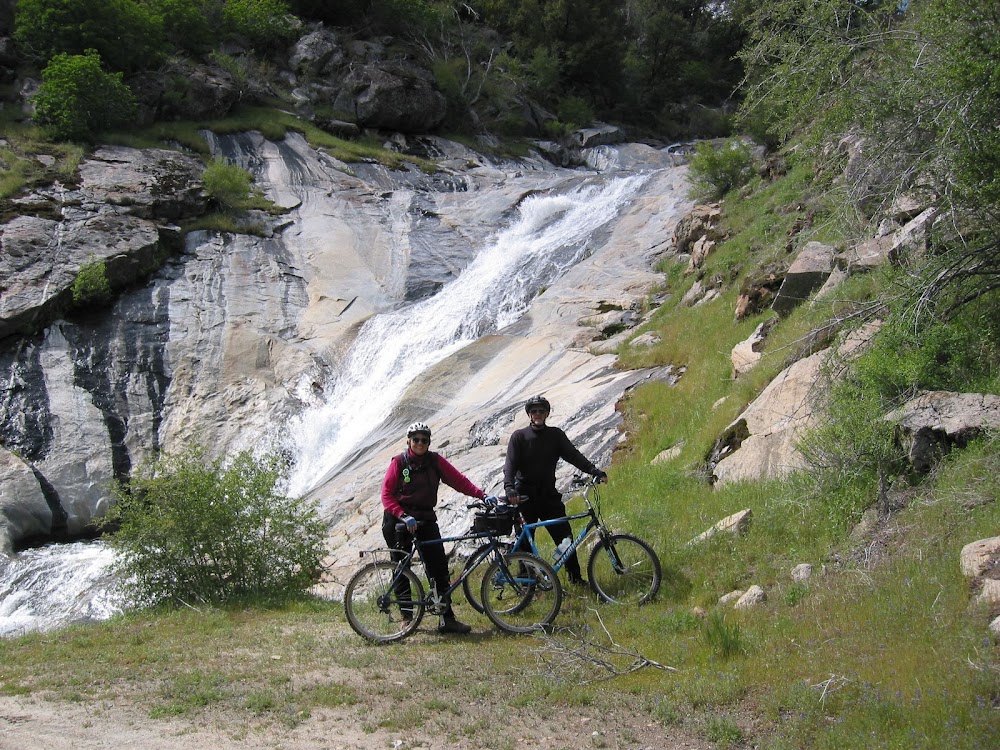
Foresta (also known as Big Meadow) is a little community that was on the old Coulterville Road, just above the point where that road dipped over the valley rim and headed down to the Valley at the Cascades. You can see the Foresta entrance road on the left, halfway up the hill on your way from the Valley to Crane Flat. It is a private in-holding that predates the National Park. It burned down in the great Arch Rock Fire of 1990, but the homes have been rebuilt and they survived last year's uncontrolled burn at Big Meadow. Foresta Road, called Crane Creek Road on some maps, is a gated dirt road that goes from Foresta to El Portal, past three beautiful waterfalls. One way length is six miles, and it has a 2300 foot descent. It is kept more or less in repair because it is a fire evacuation route for the Foresta residents (who have a key to the gates). The gates do not affect bicycles.
I have done it many times, both on bike and on foot, and have only seen a vehicle on it once. That was a pickup carrying a chain saw, looking for windfalls I suppose. But in decent weather you will see a few hikers and joggers. The road is mostly in the National Forest, and is normally scraped once a year in July, to prepare it for the fire season. Before that, in the Spring when the waterfalls are best seen, it is in some years passable only by four wheel drive vehicles with good clearance, because there is a section just below the park boundary which sometimes gets five-inch-deep erosion ruts over the winter (This year they were like that. Two years ago they weren't noticeable). These can run across the road, or they can run straight down the road and then veer off to one side. If you keep your eyes open, and are not too proud to go slowly and stop when necessary, you can easily handle them on a bike. I'm a cautious biker, and when I did it this June, I only had to hop off once to lift the bike over a deep rut. Generally, you can stick to the shoulders and/or look ahead for places where the rut walls have broken down and you can cross them. This rough section is only a quarter mile or so long. Otherwise, the road is a good biking route for anyone with knobbly tires and dependable brakes, with a few sandy spots and a few gravelly spots.
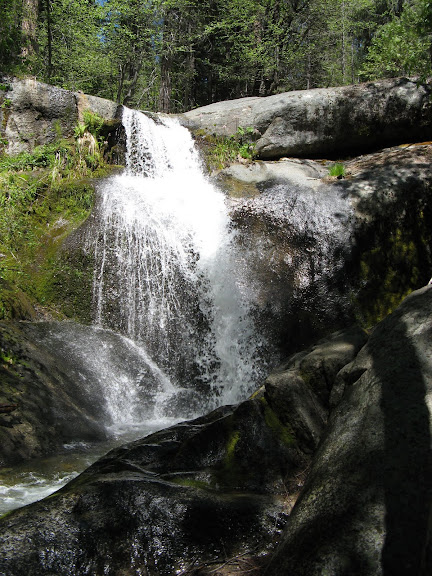
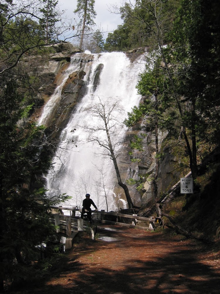
I mention three waterfalls, but in fact Crane Creek is a continuous cascade for the first thousand vertical feet. The road builders had scenic beauty in mind, for each of the three bridges is placed just below a superb fall (though the individual drops are modest by Yosemite standards). In the Spring, the creek makes a long white staircase down the mountainside. I am posting a few photos taken in late April of 2003, when the creek was flowing well. Crane Creek drains a relatively small area near Crane Flat, and melts off early, though it ran at least a month later than usual this year due to the late Spring.
First Bridge:
Standing at Second Bridge:
Another view of Second Bridge:
Standing at Third Bridge:
The first part of the road immediately below Foresta is the old McCauley Ranch, which is now abandoned and within the park. After the Arch Rock Fire, it was proposed to rebuild it as a horse staging area and Volunteers-In-Service (?) campground, but that never happened. The first bridge that you cross while biking (Foresta Falls) is within the boundary of the ranch. Shortly beyond that you will come to a gate marking the park boundary. Even when the gate is closed, it's no problem for bicycles and hikers. There is another gate near the Foresta end, which is also no problem. The gate may be open, but don't drive your vehicle through it. The gate at the other end may be closed, and the one you came through could be closed when you get back. This is not a good way to avoid the park entrance fee....
When you get to El Portal, you still have some options. Foresta Road continues at least another five miles or so along the north side of the river, a legacy of the old Yosemite Railroad. You will pass the huge new Park Service complex, built on a former barium mine site, which has a big modern bridge connecting it to highway 140. You can continue on the former railroad bed past the tiny community of Incline, where the famous loggers' incline railroad to Trumbull Peak used to be. Somewhere beyond that you will come to a closed gate where the old railroad bed becomes a private road, and you turn around. Or, if you are doing a car spot, you can park it near there....
We usually do the route one way. Either we have a car waiting in El Portal, or the strongest biker turns around at the second bridge and goes up to bring the car around to the bottom.
If you are a Spring flower photographer, note that this is a great six mile hike. The season here is early, though, and I wouldn't want to hike it in the heat of August.
The old maps show a foot trail down the east side of Crane Creek, from McCauley Ranch to El Portal. As far as I know, it disappeared even before the brush grew up after the Arch Rock Fire. It must have been very steep. If anyone knows more, I would appreciate learning about it. For now, I'll stick with the road.
Getting to Foresta: There is really only one road turning west off Big Oak Flat Road between Crane Flat and the Valley. It is near a trailhead parking lot, and is marked "Foresta". The first part of this road is relatively new, until it makes a right angle bend at the Foresta dumpsters, which is where you are joining the Old Coulterville Road. The dumpsters hide the continuation of the old road into the valley, which is abandoned. You will soon encounter some side streets with houses, but the only real junction is where Foresta Road goes left and the Old Coulterville Road goes right. Foresta Road then crosses a small bridge over Crane Creek, and turns south.
Parking: Foresta is private property, but the roadway is presumably public. Nevertheless, park in an unobtrusive place where you aren't in anyone's way and won't have to turn around in someone's driveway. I always park on the right side of the road at the junction with the second side street after the little bridge over Crane Creek in Foresta (Dana Way, the last side street on the right). The settlement ends just beyond that point. The only other bit of navigation necessary is at McCauley Ranch, where the road makes a complete switchback and and a rough entry road of some sort continues a short distance into the former ranch. Don't worry, you can't get lost and there are no possible side roads until you are in El Portal.
If there is any interest in this stuff, I can post our last Friday's ride on the gated Old Tioga Pass Road: Aspen Valley (round trip, 13 miles, 1200 foot vertical rise, pretty good road surface)
Edited 1 time(s). Last edit at 12/03/2014 09:48PM by wherever.