The lightning caused fires of July and August continue to burn in Yosemite wilderness and are being managed for multiple objectives. This means fire managers and firefighters may use less aggressive or minimal actions where the fire is accomplishing benefits on the land. For example, the fire may burn the understory of trees, ridding the area of accumulations of dead and down vegetation.
In wilderness areas, Minimum Impact Management Tactics (MIMT) are utilized by using natural barriers of rock and lakes, or utilizing trails and past fires thereby lessening the use of aggressive hand tools, i.e. chain saws. Utilizing the minimal tool and natural features further reduces the work needed to rehabilitate the fire area. Firefighters do this without diverting their attention from the safety of themselves or the public. These adjustments firefighters make to effect minimum resource impacts are essential if the spirit of wilderness and National Parks is to be maintained.
New Fire: Cloud (37 46.208x119 29.046; 9,500’ el., Mariposa Co.) This fire was found by a hiker August 30, 2010. The 20’x60’ fire has been determined to be human caused (escaped campfire) by firefighters on scene, and will be suppressed under a “confine and contain” strategy. The fire is east/southeast of Cloud’s Rest, and smoke was visible from Glacier Point and other park locations. To all campers and backpackers, please be sure your campfire is dead-out, by drowning your fire with water before leaving your campsites.
Slope fire: (37 54.572 x 119 40.924; 6900’ el., Tuolumne Co). The Slope fire is at 1007 acres. The fire activity was low to moderate in spread, and growth, due to much cooler temperatures. Fifty percent of the perimeter is active, most to the northeast. It continues to burn in brush, timber and heavy accumulations of dead and down vegetation, through an area with no recorded fire history. This lightning caused fire began July 25. Light smoke is visible along Tioga Rd, White Wolf area, O’Shaughnessy Dam of the Hetch Hetchy Reservoir, Rancheria trail area, and in the Tuolumne Meadows area. Six firefighters are assigned.
The fire has crossed the trail from Harden Lake to Pate Valley and is adjacent to all other trails to Pate Valley. Consequently the decision was made by Wilderness and Fire Management officers to close all trails in the area to Pate Valley from White Wolf for safety to hikers and backpackers.
Vernon: (37 59.813 x 119 43.618; approximately 7000’ el., Tuolumne Co.) This fire has grown to approximately 395 acres. It is creeping through brush and timber, with flanking and backing movement to the southeast. Sixty percent of the perimeter is active. This lightning caused fire is in designated wilderness, and will be managed for multiple objectives, primarily forest restoration. It is approximately three miles north of Hetch Hetchy Reservoir and one half mile south of Lake Vernon. There is significant lightning caused fire history near this fire; the most recent being the 2006 Frog, and the 2005 Wapama fires. Five firefighters are assigned.
The fire has crossed the trail to Lake Vernon from the Tiltill Valley Junction from the south and is closed.

The Moon is Waxing Gibbous (74% of Full)
Yosemite Fires – Update #23– September 15, 2010
All posts are those of the individual authors and the owner
of this site does not endorse them. Content should be considered opinion
and not fact until verified independently.
August 31, 2010 03:11PM | Admin Registered: 15 years ago Posts: 17,051 |
September 02, 2010 02:42PM | Admin Registered: 15 years ago Posts: 17,051 |
The lightning caused fires of July and August continue to burn in Yosemite wilderness and are being managed for multiple objectives. This means fire managers and firefighters may use less aggressive or minimal actions where the fire is accomplishing benefits on the land. For example, the fire may burn the understory of trees, ridding the area of accumulations of dead and down vegetation.
In wilderness areas, Minimum Impact Management Tactics (MIMT) are utilized by using natural barriers of rock and lakes, or utilizing trails and past fires thereby lessening the use of aggressive hand tools, i.e. chain saws. Utilizing the minimal tool and natural features further reduces the work needed to rehabilitate the fire area. Firefighters do this without diverting their attention from the safety of themselves or the public. These adjustments firefighters make to effect minimum resource impacts are essential if the spirit of wilderness and National Parks is to be maintained.
Slope: (37 54.572 x 119 40.924; 6900’ el., Tuolumne Co). The Slope fire is at 1027 acres. The fire activity was low in spread, and growth, due to much cooler temperatures and higher humidities. Only 40 percent of the perimeter is active, most to the northeast. It continues to burn in brush, timber and heavy accumulations of dead and down vegetation, through an area with no recorded fire history. This lightning caused fire began July 25. Smoke was rising to 600’ above the ground and dispersing to the northeast. Light smoke may be visible along Tioga Rd, White Wolf area, O’Shaughnessy Dam of the Hetch Hetchy Reservoir, Rancheria trail area, and in the Tuolumne Meadows area. Six firefighters are assigned.
The fire has crossed the trail from Harden Lake to Pate Valley and is adjacent to all other trails to Pate Valley. Consequently the decision was made by Wilderness and Fire Management officers to close all trails in the area to Pate Valley from White Wolf for safety to hikers and backpackers.
Vernon: (37 59.813 x 119 43.618; approximately 7000’ el., Tuolumne Co.) The acreage has been revised downward to 377 acres. It is creeping through brush and timber, with flanking and backing movement to the southeast. One foot flame lengths were observed by fire monitors. Light smoke was dispersing to the northeast at 600’ above the ground. This lightning caused fire is in designated wilderness, and will be managed for multiple objectives, primarily forest restoration. It is approximately three miles north of Hetch Hetchy Reservoir and one half mile south of Lake Vernon. There is significant lightning caused fire history near this fire; the most recent being the 2006 Frog, and the 2005 Wapama fires. Three firefighters are assigned.
The fire has crossed the trail to Lake Vernon from the Tiltill Valley Junction from the south and the trail is closed.
Cooperators for both the Vernon and Slope fires include the San Francisco Public Utilities Commission, and the Tuolumne County Air Pollution Control District.
Other park fires: The Cloud human caused fire near Clouds Rest is out and in patrol status. The Tuolumne and Wildcat 2 fires are inactive and in patrol status.
September 02, 2010 07:00PM | Registered: 15 years ago Posts: 145 |
Quote
eeek
Slope fire: (37 54.572 x 119 40.924; 6900’ el., Tuolumne Co). The Slope fire is at 1007 acres. The fire activity was low to moderate in spread, and growth, due to much cooler temperatures. Fifty percent of the perimeter is active, most to the northeast. It continues to burn in brush, timber and heavy accumulations of dead and down vegetation, through an area with no recorded fire history. This lightning caused fire began July 25. Light smoke is visible along Tioga Rd, White Wolf area, O’Shaughnessy Dam of the Hetch Hetchy Reservoir, Rancheria trail area, and in the Tuolumne Meadows area. Six firefighters are assigned.
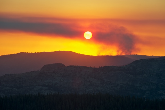
Here's the view at sunset on Tuesday August 24 from Peak 10410, just south of Young Lakes. Given the description and my location, I'm pretty sure this is the Slope Fire.
September 07, 2010 12:55PM | Admin Registered: 15 years ago Posts: 17,051 |
The lightning caused fires of July and August continue to burn in Yosemite wilderness and are being managed for multiple objectives. This means fire managers and firefighters may use less aggressive or minimal actions where the fire is accomplishing benefits on the land. For example, the fire may burn the understory of trees, ridding the area of accumulations of dead and down vegetation.
In wilderness areas, Minimum Impact Management Tactics (MIMT) are utilized by using natural barriers of rock and lakes, or utilizing trails and past fires thereby lessening the use of aggressive hand tools, i.e. chain saws. Utilizing the minimal tool and natural features further reduces the work needed to rehabilitate the fire area. Firefighters do this without diverting their attention from the safety of themselves or the public. These adjustments firefighters make to effect minimum resource impacts are essential if the spirit of wilderness and National Parks is to be maintained.
Slope: (37 54.572 x 119 40.924; 6900’ el., Tuolumne Co). The Slope fire is at 1100 acres. The fire activity was low to moderate in growth and spread over the Labor Day weekend. Fifty percent of the perimeter is active, mostly to the south. It continues to burn in brush, timber and heavy accumulations of dead and down vegetation, through an area with no recorded fire history. This lightning caused fire began July 25. Smoke was rising to 700’ above the ground and dispersing to the northeast. Light smoke may be visible along Tioga Rd, White Wolf area, O’Shaughnessy Dam of the Hetch Hetchy Reservoir, Rancheria trail area, and in the Tuolumne Meadows area. Five firefighters are assigned.
The fire has crossed the trail from Harden Lake to Pate Valley and is adjacent to all other trails to Pate Valley. Consequently the decision was made by Wilderness and Fire Management officers to close all trails in the area to Pate Valley from White Wolf for safety to hikers and backpackers.
Vernon: (37 59.813 x 119 43.618; approximately 7000’ el., Tuolumne Co.) The fire acreage is at 405. It is creeping through brush and timber, with flanking and backing movement with the most active perimeter to the northeast. One foot flame lengths and low fire activity were observed by fire monitors. Light smoke was dispersing to the northeast at 600’ above the ground. This lightning caused fire is in designated wilderness, and will be managed for multiple objectives, primarily forest restoration. It is approximately three miles north of Hetch Hetchy Reservoir and one half mile south of Lake Vernon. There is significant lightning caused fire history near this fire; the most recent being the 2006 Frog, and the 2005 Wapama fires. Four firefighters are assigned.
The fire has crossed the trail to Lake Vernon from the Tiltill Valley Junction from the south and the trail is closed.
Other park fires: The Cloud, a human caused fire near Clouds Rest, is out and in patrol status. The Tuolumne and Wildcat 2 fires are inactive and in patrol status.
September 13, 2010 10:39AM | Admin Registered: 15 years ago Posts: 17,051 |
The lightning caused fires of July and August continue to burn in Yosemite wilderness and are being managed for multiple objectives. This means fire managers and firefighters may use less aggressive or minimal actions where the fire is accomplishing benefits on the land. For example, the fire may burn the understory of trees, ridding the surface areas of accumulations of dead and down vegetation.
The Slope and Vernon fires to date have been burning for nearly six weeks in areas with little or no fire history. Both of these fires have aided significantly in restoring forest health by the return of fire to the landscape. The fires have been managed and monitored with little intervention by firefighters, allowing the fires to move in natural directions
Smoke production and impacts continue to be minimal for both fires.
In wilderness areas, Minimum Impact Management Tactics (MIMT) are utilized by using natural barriers of rock and lakes, or utilizing trails and past fires thereby lessening the use of aggressive hand tools, i.e. chain saws. Utilizing the minimal tool and natural features further reduces the work needed to rehabilitate the fire area. Firefighters do this without diverting their attention from the safety of themselves or the public. These adjustments firefighters make to effect minimum resource impacts are essential if the spirit of wilderness and National Parks is to be maintained.
Slope: (37 54.572 x 119 40.924; 6900’ el., Tuolumne Co). The Slope fire is to approximately 1213 acres. The fire activity continues to be low in growth and spread due to cooler temperatures and higher humidities. Fifty percent of the perimeter is active, mostly to the south and east. The fire is poised to enter into the 1999 Morrison and the 1985 fires footprints and has already burned around the 2005 Harden lake fire. This fire continues to fill in a key piece of the fire mosaic near the White Wolf area. It is burning in brush, timber and heavy accumulations of dead and down vegetation. This lightning caused fire began July 25. Light smoke may be visible along Tioga Rd, White Wolf area, O’Shaughnessy Dam of the Hetch Hetchy Reservoir, Rancheria trail area, and in the Tuolumne Meadows area. Five firefighters are assigned. Five Yosemite Crew 7 firefighters are
assigned.
All trails to Pate Valley from the White Wolf campground area are closed due to safety concerns to hikers and backpackers. Safety issues include hot stump holes, snags, smoke and falling tree limbs. Access to Pate Valley and the Grand Canyon of the Tuolumne River can be made from Glen Aulin.
Vernon: (37 59.813 x 119 43.618; approximately 7000’ el., Tuolumne Co.) The fire acreage is at 435. It is creeping through brush and timber, with flanking and backing movement with the most active perimeter to the northeast. One foot flame lengths and low fire activity were observed by fire monitors. Light smoke was dispersing to the northeast at 600’ above the ground. It is approximately three miles north of Hetch Hetchy Reservoir and one half mile south of Lake Vernon. There is significant lightning caused fire history near this fire; the most recent being the 2006 Frog, and the 2005 Wapama fires. Four Yosemite Crew 6 firefighters are assigned.
and the 2005 Wapama fires. Four Yosemite Crew 6 firefighters are assigned. The fire has crossed the trail to Lake Vernon from the Tiltill Valley Junction from the south and the trail is closed.
Cooperators for both the Vernon and Slope fires include the San Francisco Public Utilities Commission, and the Tuolumne County Air Pollution Control District.
Other park fires: The Tuolumne and Wildcat 2 fires are inactive and in patrol status.
September 15, 2010 10:33AM | Admin Registered: 15 years ago Posts: 17,051 |
The lightning caused fires of July and August continue to burn in Yosemite wilderness and are being managed for multiple objectives. This means fire managers and firefighters may use less aggressive or minimal actions where the fire is accomplishing benefits on the land. For example, the fire may burn the understory of trees, ridding the surface areas of accumulations of dead and down vegetation.
The Slope and Vernon fires have been burning for nearly six weeks in areas with little or no fire history. Both of these fires have aided significantly in restoring forest health by the return of fire to the landscape. The fires have been managed and monitored with little intervention by firefighters, allowing the fires to move in natural directions and filling in key pieces of the fire mosaic.
In wilderness areas, Minimum Impact Management Tactics (MIMT) are utilized by using natural barriers of rock and lakes, or utilizing trails and past fires thereby lessening the use of aggressive hand tools, i.e. chain saws. Utilizing the minimal tool and natural features further reduces the work needed to rehabilitate the fire area. Firefighters do this without diverting their attention from the safety of themselves or the public. These adjustments firefighters make to effect minimum resource impacts are essential if the spirit of wilderness and National Parks is to be maintained.
Slope: (37 54.572 x 119 40.924; 6900’ el., Tuolumne Co). The Slope fire is approximately 1461 acres. The fire activity continues to be low in growth and spread due to cooler temperatures and higher humidities. Fifty percent of the perimeter is active, mostly to the south. The fire is poised to enter into the 1985 and 1999 Morrison and the 2002 White Wolf fire footprints. It is burning in brush, timber and heavy accumulations of dead and down vegetation. This lightning caused fire began July 25. Light smoke may be visible along Tioga Rd, White Wolf area, O’Shaughnessy Dam of the Hetch Hetchy Reservoir, Rancheria trail area, and in the Tuolumne Meadows area. Five firefighters are assigned. Five Yosemite Crew 7 firefighters are assigned. All trails to Pate Valley from the White Wolf campground area are closed due to safety concerns to hikers and backpackers
Vernon: (37 59.813 x 119 43.618; approximately 7000’ el., Tuolumne Co.) The fire acreage is at 692. It is creeping through brush and timber, with flanking and backing movement with the most active perimeters to the northeast and west. One foot flame lengths and low fire activity were observed by fire monitors. Light smoke was dispersing to the northeast at 600’ above the ground. It is approximately three miles north of Hetch Hetchy Reservoir and one half mile south of Lake Vernon. There is significant lightning caused fire history near this fire; the most recent being the 2006 Frog, and the 2005 Wapama fires. Three Yosemite Crew 6 firefighters are assigned. The fire has crossed the trail to Lake Vernon from the Tiltill Valley Junction from the south and the trail is closed.
Cooperators for both the Vernon and Slope fires include the San Francisco Public Utilities Commission, and the Tuolumne County Air Pollution Control District.
Other park fires: The Tuolumne and Wildcat 2 fires are inactive and in patrol status.
Weather: Cooler temperatures will continue through the week of August 12.
Other fires affecting the Yosemite area: The Buckhorn fire (Sierra N.F.) and Pinecrest fire (Stanislaus N.F.) are producing localized thin smoke immediately to the south and the north of the park. Smoke from the Sheep fire (5,700 + acres) and the Canyon fire (4,000+ acres), both on the Sequoia N.F., are further to the south and do not appear to be affecting the park directly.
September 20, 2010 10:33AM | Admin Registered: 15 years ago Posts: 17,051 |
Yosemite Fires – Update #24– September 17, 2010
The lightning caused fires of July and August continue to burn in Yosemite wilderness and are being managed for multiple objectives. This means fire managers and firefighters may use less aggressive or minimal actions where the fire is accomplishing benefits on the land. For example, the fire may burn the understory of trees, ridding the surface areas of accumulations of dead and down vegetation.
The Slope and Vernon fires have been burning for nearly six weeks in areas with little or no fire history. Both of these fires have aided significantly in restoring forest health by the return of fire to the landscape. The fires have been managed and monitored with little intervention by firefighters, allowing the fires to move in natural directions and filling in key pieces of the fire mosaic. Both of these fires are showing small increases in acreage due to cooler temperatures and shorter daylight hours.
In wilderness areas, Minimum Impact Management Tactics (MIMT) are utilized by using natural barriers of rock and lakes, or utilizing trails and past fires thereby lessening the use of aggressive hand tools, i.e. chain saws. Utilizing the minimal tool and natural features further reduces the work needed to rehabilitate the fire area. Firefighters do this without diverting their attention from the safety of themselves or the public. These adjustments firefighters make to effect minimum resource impacts are essential if the spirit of wilderness and National Parks is to be maintained.
Slope: (37 54.572 x 119 40.924; 6900’ el., Tuolumne Co). The Slope fire is approximately 1506 acres. The fire activity continues to be low in growth and spread due to cooler temperatures and higher humidities. Fifty percent of the perimeter is active, mostly to the south. The fire is poised to enter into the 1985 and 1999 Morrison and the 2002 White Wolf fire footprints. Light smoke was visible and rising to 800’ above the ground and dispersing to the northeast. It is burning in brush, timber and heavy accumulations of dead and down vegetation. This lightning caused fire began July 25. Light smoke may be visible along Tioga Rd, White Wolf area, O’Shaughnessy Dam of the Hetch Hetchy Reservoir, Rancheria trail area, and in the Tuolumne Meadows area. Five Yosemite Crew 7 firefighters are assigned. All trails to Pate Valley from the White Wolf campground area are closed due to safety concerns to hikers and backpackers
Vernon: (37 59.813 x 119 43.618; approximately 7000’ el., Tuolumne Co.) The fire acreage is at 707. It is creeping through brush and timber. The most active perimeters are to the northeast and west. Low fire activity has been observed by fire monitors through the week. Light smoke was dispersing to the northeast at 600’ above the ground. It is approximately three miles north of Hetch Hetchy Reservoir and one half mile south of Lake Vernon. There is significant lightning caused fire history near this fire; the most recent being the 2006 Frog, and the 2005 Wapama fires. Three Yosemite Crew 6 firefighters are assigned. The fire has crossed the trail to Lake Vernon from the Tiltill Valley Junction from the south and the trail is closed.
Cooperators for both the Vernon and Slope fires include the San Francisco Public Utilities Commission, and the Tuolumne County Air Pollution Control District.
Other park fires: The Tuolumne and Wildcat 2 fires are inactive and in patrol status.
Other fires affecting the Yosemite area: The Buckhorn fire (Sierra N.F.) and Pinecrest fire (Stanislaus N.F.) are producing localized thin smoke immediately to the south and the north of the park. Smoke from the Sheep fire (5,700 + acres) and the Canyon fire (4,000+ acres), both on the Sequoia N.F., are further to the south and do not appear to be affecting the park directly.
Sorry, only registered users may post in this forum.

