Does the long 11,168' high ridge just south of Budd Lake between Echo Peaks and Cockscomb have a name or is it considered part of Cockscomb?
Also, does what I call "Dolly Domes Canyon" have a real name? Perhaps Echo Canyon?
These questions are for the sake of proper photo annotations.
Edited 1 time(s). Last edit at 09/17/2010 06:51AM by tomdisco.
All posts are those of the individual authors and the owner
of this site does not endorse them. Content should be considered opinion
and not fact until verified independently.
September 17, 2010 06:14AM | Registered: 15 years ago Posts: 1,876 |
September 19, 2010 09:19AM | Registered: 14 years ago Posts: 7,421 |
September 19, 2010 06:25PM | Registered: 15 years ago Posts: 1,876 |
September 19, 2010 06:32PM | Registered: 14 years ago Posts: 7,421 |
Quote
tomdisco
You have been up on Parson's Peak?
More here:
http://picasaweb.google.com/yosemite.chick.on/Lyell
btw... the ranger I got the permit from said 5000 fire rings.
Amazingly I saw none on this trip which made me very happy.
Didn't see any remnants of the Sierra Club at Bernice.. but
I didn't search around a lot since I had ground to cover and
there were 2 other people in that area. This is the first time
I have seen others camping there when there.
(the ranger also said they broke all records for visitation
and backpacking this year)

September 19, 2010 06:50PM | Registered: 15 years ago Posts: 1,876 |
Quote
chick-on
Quote
tomdisco
You have been up on Parson's Peak?
More here:
http://picasaweb.google.com/yosemite.chick.on/Lyell
btw... the ranger I got the permit from said 5000 fire rings.
Amazingly I saw none on this trip which made me very happy.
Didn't see any remnants of the Sierra Club at Bernice.. but
I didn't search around a lot since I had ground to cover and
there were 2 other people in that area. This is the first time
I have seen others camping there when there.
(the ranger also said they broke all records for visitation
and backpacking this year)
Yeh, I thought he said 5,000 fire rings but wasn't sure so I ramped it down to 3,000.
September 19, 2010 08:37PM | Admin Registered: 15 years ago Posts: 17,050 |
September 20, 2010 06:43AM | Registered: 15 years ago Posts: 1,876 |
Quote
eeek
Quote
tomdisco
Yeh, I thought he said 5,000 fire rings but wasn't sure so I ramped it down to 3,000.
But where did he get the 5,000 from?
According to Ranger "Craig" at TM there are a little more than 5,000 and they have all of them, both legal and illegal locations, plotted on GPS coordinates. Apparently the rangers have been recording coordinates over a considerable period of time and continue adding new ones as they are discovered.
June 28, 2011 02:54PM | Registered: 14 years ago Posts: 7,421 |
David Rumsey Historical Map Collection:
Distribution of Campfire Rings in the Backcountry Wilderness of Yosemite National Park, California, 1972.
http://www.davidrumsey.com

Collection: David Rumsey Historical Map Collection
Author: Holmes, Joseph Edward
Date: 1973
Short Title: Campfire Rings in the Backcountry of Yosemite National Park, 1972.
Type: Separate Map
Scale 1: 63,630
Note: Hand drawn annotations on twelve U. S. Geological Survey 15-minute topographical basemaps. A series of symbols represent the different sizes of about 4500 fire rings and corresponding trampled areas. Plotting of fire rings follows a complex protocol. Detailed explanatory legend. Original in the Yosemite National Park Archives.
Region: Yosemite National Park
Full Title: Distribution of Campfire Rings in the Backcountry Wilderness of Yosemite National Park, California, 1972.
List No: 5787.000
Engraver or Printer: Holmes, Joseph Edward
Publication Author: Holmes, Joseph Edward
Pub Date: 1973
Pub Title: Distribution of Campfire Rings in the Backcountry Wilderness of Yosemite National Park, California, 1972.
Pub Note: See Note field.
Pub List No: 5787.000
Pub Type: Separate Map
Image No: 5787000
Institution: Rumsey Collection
Ownership Statement: Copyright 2009
-----------------------------------------------------------------------------------------------------------------------------------------------
**NOTE-would put the direct link to the image for zooming, etc.... but this forum bonks on the url...
Just search google for "yosemite firerings 1972" and you should find it....
Distribution of Campfire Rings in the Backcountry Wilderness of Yosemite National Park, California, 1972.
http://www.davidrumsey.com
Collection: David Rumsey Historical Map Collection
Author: Holmes, Joseph Edward
Date: 1973
Short Title: Campfire Rings in the Backcountry of Yosemite National Park, 1972.
Type: Separate Map
Scale 1: 63,630
Note: Hand drawn annotations on twelve U. S. Geological Survey 15-minute topographical basemaps. A series of symbols represent the different sizes of about 4500 fire rings and corresponding trampled areas. Plotting of fire rings follows a complex protocol. Detailed explanatory legend. Original in the Yosemite National Park Archives.
Region: Yosemite National Park
Full Title: Distribution of Campfire Rings in the Backcountry Wilderness of Yosemite National Park, California, 1972.
List No: 5787.000
Engraver or Printer: Holmes, Joseph Edward
Publication Author: Holmes, Joseph Edward
Pub Date: 1973
Pub Title: Distribution of Campfire Rings in the Backcountry Wilderness of Yosemite National Park, California, 1972.
Pub Note: See Note field.
Pub List No: 5787.000
Pub Type: Separate Map
Image No: 5787000
Institution: Rumsey Collection
Ownership Statement: Copyright 2009
-----------------------------------------------------------------------------------------------------------------------------------------------
**NOTE-would put the direct link to the image for zooming, etc.... but this forum bonks on the url...
Just search google for "yosemite firerings 1972" and you should find it....
June 28, 2011 04:30PM | Registered: 15 years ago Posts: 4,173 |
June 28, 2011 08:03PM | Registered: 14 years ago Posts: 7,421 |
Most of the west is heavy forest... not a huge number of lakes. Not as many trails... not as scenic...
Even then... go thru the same area a few years later... and I always find new fire rings... sigh...
Here's the link to zoom in and all:
Yosemite Firering in the Backcountry - 1972
Even then... go thru the same area a few years later... and I always find new fire rings... sigh...
Here's the link to zoom in and all:
Yosemite Firering in the Backcountry - 1972
June 28, 2011 08:21PM | Admin Registered: 15 years ago Posts: 17,050 |
June 28, 2011 08:30PM | Registered: 14 years ago Posts: 7,421 |
I doubt you find many there now. The trail from the Middle Fork down to Ackerson Mdws. is no moreQuote
eeek
What's with that cluster north of Bald Mountain?
even though the trail sign is still there...
I'm not sure I'll even attempt the shrubbery whacking it would take to do that now.
I presume it was fishermen heading up to the MF from Ackerson.
Baseline camp is also no more... so the rings have probably been scattered for awhile now..
I've never seen anyone on that trail the few times I have been on it.
Next time I'm up there I'll look around... somehow I missed the BM when I was up on Bald...
Edited 1 time(s). Last edit at 06/28/2011 08:31PM by chick-on.
|
Re: Peak identification & other stuff June 28, 2011 10:43PM | Registered: 14 years ago Posts: 755 |
Quote
plawrence
I find it interesting that there are relatively few fire rings located in the western half of Yosemite National Park. Most seem to be located in the higher elevations, some quite close the to timberline.
The other factor is that you only find fire rings where you actually look. And they are harder to see in the forested regions. But there are lots of trails, like the El Cap Trail and the Pohono Trail west of Bridalveil Creek, that have plenty of old fire rings.
Was he, perhaps, only plotting rings that showed signs of recent use when he passed by?
|
Re: Peak identification & other stuff August 11, 2011 08:33AM | Registered: 12 years ago Posts: 3 |
A most interesting map, thanks for posting a link to it. It sure tells people where never to even think of camping and the bears where to look for food. I remember running into crews removing fire rings around 1970 or so and trying to clean up a lot of these areas. I remember counting over 450 people, yes 450 people, going in one morning at Agnew Meadows heading toward Shadow, Garnet, or Thousand Island lakes. I counted them on my way out from Banner/Ritter area via Shadow Lake in mid August. There were a lot of large groups of 30+ people that came in on buses; these groups were mostly youth groups and boy scouts. Shadow Lake looked like an extremely crowded third world refugee camp full of Bart Simpson types with heavy smoke from campfires. I am sure happy the rules have changed!
September 21, 2010 07:25PM | Registered: 14 years ago Posts: 1,634 |
I don't know how to place a Google Earth place mark here, but does anyone know if this ridge has a name?
Going East on Tioga Road, just past the bridge that crosses one of the forks of the Tuolumne River, it's on the left, which should be North.
The Google Earth coordinates are: Lat. 37.799502° Long. -119.726208°
I drive by it at least twice a week and it looks like it should be easy to get to the top of the ridge. I haven't seen it named on any map I could find.
September 22, 2010 09:11AM | Moderator Registered: 15 years ago Posts: 1,918 |
I really like that domage too.
Highly doubt that it is named.
How about "Davey Llama Dome"
I've been spying where to park to get to it nearly every time I drive by.
Know I mentioned to the wifey a few times "I wanna go there".
Nowhere really to park until quite east of it though.
Prob have to park around BM 7158 or near BM 7300 by the
nice sloped exfoliated granite cut.
If you ever go let us know .. as will I.
September 22, 2010 07:18PM | Registered: 14 years ago Posts: 1,634 |
I was planing on continuing past the dome about half a mile or so and there is space to park a car on the right side. This is right where the canyon between the road and the dome rises up to meet the road. It should be a fairly easy hike along the ridge to the top.
The spot I'm thinking of parking is where there used to be an old camp of some kind.
I just looked it up in the "Yosemite Road Guide." It's right at post "T6". The camp was called "Smoky Jack." According to the book it's 1.8 miles from the South Fork of the Tuolumne River. It also says not to stop because it's dangerous. That's never stopped me.
September 22, 2010 07:36PM | Moderator Registered: 15 years ago Posts: 1,918 |
September 22, 2010 07:47PM | Registered: 14 years ago Posts: 1,634 |
I'll be driving by there Friday. My work truck is too big to fit in any of those spaces.
Now, don't tell anyone about this secret spot; coming from the other direction, maybe a 1/4 miles West of Smoky Jacks there is a small pullout/gravel patch on the left side. There's some kind of sign there too. The base of Dave's Ridge is close to the road here. Park there and take a short walk downhill to a little stream, with a little pool good for soaking in, with a little waterfall to the right. Beautiful little spot. There should still be water in it.
Now, don't tell anyone about this secret spot; coming from the other direction, maybe a 1/4 miles West of Smoky Jacks there is a small pullout/gravel patch on the left side. There's some kind of sign there too. The base of Dave's Ridge is close to the road here. Park there and take a short walk downhill to a little stream, with a little pool good for soaking in, with a little waterfall to the right. Beautiful little spot. There should still be water in it.
|
Re: Peak identification & other stuff September 27, 2010 04:58PM | Registered: 14 years ago Posts: 755 |
Quote
Dave
I was planing on continuing past the dome about half a mile or so and there is space to park a car on the right side. This is right where the canyon between the road and the dome rises up to meet the road. It should be a fairly easy hike along the ridge to the top.
The spot I'm thinking of parking is where there used to be an old camp of some kind.
I just looked it up in the "Yosemite Road Guide." It's right at post "T6". The camp was called "Smoky Jack." According to the book it's 1.8 miles from the South Fork of the Tuolumne River. It also says not to stop because it's dangerous. That's never stopped me.
The former Smoky Jack campground is on the Topo USA maps. It's shown at N37.818° W119.7128°, which of course was just to the north of where the road crosses the creek, on the east shoulder of the road, and where there is some nearly level ground.
I've been eying that spot on the map as the possible start of a hike, too. It would be easy to get up onto the slickrock from there. How can there be no place to pull off where a campground entrance used to be?
September 27, 2010 05:14PM | Registered: 14 years ago Posts: 7,421 |
The T6 sign is right at the entrance to the old campground.
There's a couple of big boulders to prohibit entrance...
however, it sure looks like you could pull in enough off the road
for a nice hike. Was too lazy to investigate any further yesterday...
He who does Davey Llama Dome first... please report back...
with pictures...!
There's a couple of big boulders to prohibit entrance...
however, it sure looks like you could pull in enough off the road
for a nice hike. Was too lazy to investigate any further yesterday...
He who does Davey Llama Dome first... please report back...
with pictures...!
September 27, 2010 05:34PM | Registered: 14 years ago Posts: 1,634 |
I was too busy working. I did get a pile of old climbing ropes from the cleanup. I need a new rug for my house.Quote
chick-on
The T6 sign is right at the entrance to the old campground.
There's a couple of big boulders to prohibit entrance...
however, it sure looks like you could pull in enough off the road
for a nice hike. Was too lazy to investigate any further yesterday...
He who does Davey Llama Dome first... please report back...
with pictures...!
I'd hike Dave's Dome next week... but I have some surgery done on my toe before I can hike without a huge amount of pain. That's going to be done sometime in the middle of next month. Give me a week for recovery and I'll propose a hike.
September 27, 2010 05:31PM | Registered: 14 years ago Posts: 1,634 |
There's maybe room for two cars in two different spots.Quote
wherever
The former Smoky Jack campground is on the Topo USA maps. It's shown at N37.818° W119.7128°, which of course was just to the north of where the road crosses the creek, on the east shoulder of the road, and where there is some nearly level ground.
It's been awhile and the trees grew back.Quote
I've been eying that spot on the map as the possible start of a hike, too. It would be easy to get up onto the slickrock from there. How can there be no place to pull off where a campground entrance used to be?
September 27, 2010 07:05AM | Registered: 14 years ago Posts: 7,421 |
September 27, 2010 07:30PM | Moderator Registered: 15 years ago Posts: 1,876 |
Quote
chick-on
Chick-on must be a fan of Cubism: http://www.artchive.com/artchive/P/picasso_analyticalcubism.html
Edited 1 time(s). Last edit at 09/27/2010 07:31PM by szalkowski.
September 27, 2010 07:56AM | Registered: 14 years ago Posts: 7,421 |
September 27, 2010 11:53AM | Registered: 15 years ago Posts: 1,876 |
September 27, 2010 01:35PM | Moderator Registered: 15 years ago Posts: 1,918 |
September 28, 2010 04:32PM | Registered: 15 years ago Posts: 1,876 |
September 29, 2010 08:54AM | Registered: 14 years ago Posts: 7,421 |
Quote
tomdisco
Quote
bill-e-g
Quote
tomdisco
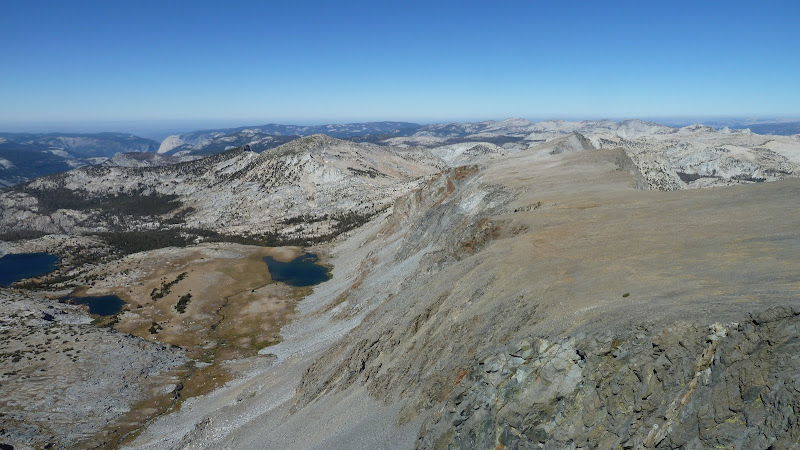
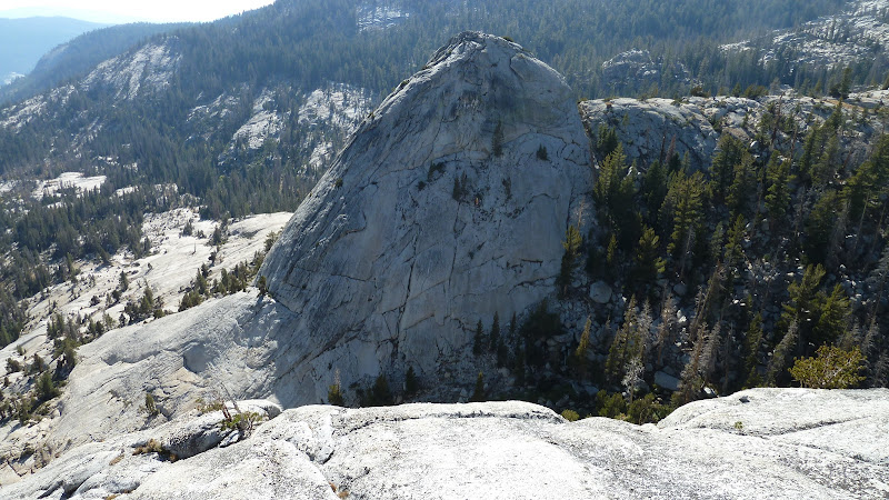
9,153' unnamed dome across from Fairview Dome?
Sorry... thought this one would be obvious to you.
It's looking north. The dome is "named".
Shame on me. One of the Dolly Domes?
It's the left one. Sticky climb to the top.
Right one not so easy.
Here's the right one:
September 29, 2010 10:47AM | Registered: 15 years ago Posts: 2,321 |
September 29, 2010 11:10AM | Registered: 14 years ago Posts: 7,421 |

September 29, 2010 11:58AM | Registered: 15 years ago Posts: 2,321 |
Ahhh!! The joy of ambiguity or something like that.
So, we were camped to the left of the left dome looking from Sunrise or to the rightmost of the right dome in this picture then?
Except we were camped in the cleavage Friday which is the same from either direction.
Old Dude
Edited 1 time(s). Last edit at 09/29/2010 12:03PM by mrcondron.
So, we were camped to the left of the left dome looking from Sunrise or to the rightmost of the right dome in this picture then?
Except we were camped in the cleavage Friday which is the same from either direction.
Old Dude
Edited 1 time(s). Last edit at 09/29/2010 12:03PM by mrcondron.
September 29, 2010 11:35AM | Registered: 15 years ago Posts: 1,876 |

September 29, 2010 11:49AM | Registered: 15 years ago Posts: 2,321 |
September 30, 2010 12:46PM | Registered: 15 years ago Posts: 1,876 |
|
Re: Peak identification & other stuff August 11, 2011 11:58PM | Registered: 13 years ago Posts: 931 |
Sorry, only registered users may post in this forum.

