Special weather statement
National weather service san joaquin valley - hanford ca
623 am pdt sun oct 3 2010
Caz089>099-032200-
West central san joaquin valley-east central san joaquin valley-
Southwestern san joaquin valley-southeastern san joaquin valley-
Mariposa madera and fresno county foothills-
Tulare county foothills-kern county mountains-
Sierra nevada from yosemite to kings canyon-
Tulare county mountains-indian wells valley-
Southeastern kern county desert-
623 am pdt sun oct 3 2010
...Showers and thunderstorms today...
...Much cooler and unsettled through mid week...
Showers and thunderstorms will be possible across all of the
Central california interior again today. The airmass remains
Rather moist...And some spotty heavy rains are possible. Most
Numerous showers and storms are expected late this afternoon into
The overnight hours.
Scattered showers and thunderstorms will occur across the
Mountains and deserts of interior central california through at
Least thursday. Significant rains and high elevation snows are
Possible monday night and tuesday.
The snow level will remain quite high through tonight...Then
Lower to 8000 to 9000 feet monday. The snow level will then vary
From 7500 to 9000 feet through the week. How much snow will occur
In the highest elevations of the southern sierra over the course
Of the week is of considerable uncertainty right now. There is a
Small potential however for significant snow on yosemite parks
Tioga pass monday night or tuesday.
Travelers...Hikers...And campers in the high country the next
Several days should keep abreast of the latest forecast. Even if a
Significant amount of snow does not occur below 9000 or 10000
Feet...It will still be quite unsettled and cold in the high
Country.
$$
Bingham

The Moon is Waxing Gibbous (74% of Full)
Re: Special weather statement
All posts are those of the individual authors and the owner
of this site does not endorse them. Content should be considered opinion
and not fact until verified independently.
October 03, 2010 07:15AM | Admin Registered: 15 years ago Posts: 17,051 |
October 03, 2010 05:41PM | Admin Registered: 15 years ago Posts: 17,051 |
Special weather statement
National weather service san joaquin valley - hanford ca
244 pm pdt sun oct 3 2010
Caz089>099-040500-
West central san joaquin valley-east central san joaquin valley-
Southwestern san joaquin valley-southeastern san joaquin valley-
Mariposa madera and fresno county foothills-
Tulare county foothills-kern county mountains-
Sierra nevada from yosemite to kings canyon-
Tulare county mountains-indian wells valley-
Southeastern kern county desert-
244 pm pdt sun oct 3 2010
...Much cooler and unsettled weather monday through wednesday...
A cold front will move inland tonight and bring a significantly
Cooler airmass into the central california interior during the
Next few days. Prior to its arrival...This evening will remain
Rather muggy with isolated showers and thunderstorms. Showers
Will become more numerous later tonight and continue through
Monday...Especially over the higher terrain. Briefly heavy rain
Is possible in some areas tonight and monday with the potential
For localized flooding over the higher elevations. Otherwise...
Temperatures monday afternoon will be a good 15 to 20 degrees
Cooler than this weekend.
A low pressure system aloft will develop over central california
By monday evening and remain nearly stationary through wednesday.
During this time...We can expect unseasonably cool temperatures
And a chance of showers. The air will become cold enough for
Accumulating snow over the highest elevations of the sierra by
Late monday night or tuesday.
Snow levels will remain quite high through tonight...Then lower
To 8000 to 9000 feet monday. The snow level will then vary from
7500 to 9000 feet through midweek. Although confidence is low as
To how much snow may fall over the highest elevations... There is
Potential for several inches accumulation over tioga pass in
Yosemite national park monday night or tuesday.
Travelers...Hikers...And campers in the high country the next
Several days should keep abreast of the latest forecast. Even if
A significant amount of snow does not occur above 7500 feet...
It will still be quite cold in the high country.
$$
Durfee
|
Re: Special weather statement October 03, 2010 08:16PM | Registered: 15 years ago Posts: 543 |
October 03, 2010 08:20PM | Admin Registered: 15 years ago Posts: 17,051 |
October 04, 2010 05:54PM | Registered: 15 years ago Posts: 2,321 |
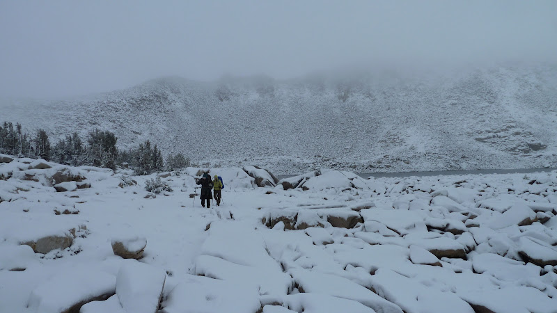
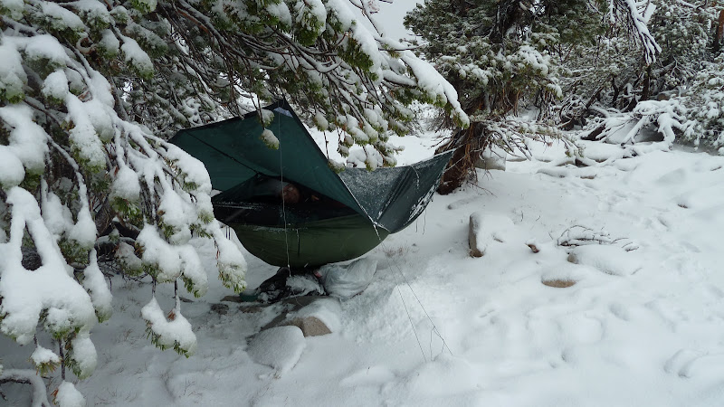
Just got back from three days of hunkering down with Bill-e-g and the Goat Whisperer at the little lake WL10439 just south east of Elizabeth Lake. We arrived at the WL lake early Saturday afternoon and were no sooner pitched than when it started raining. It rained through the night with a respite now and then. We intended to go over to Reymann Lake and then to Matthes Lake Sunday but the rain and wind were unrelenting. Sunday night it snowed all night. There was lots of very close lightening strikes and marvelous thunder all three days. Monday morning about 10AM it stopped snowing and we bailed. Got back to the car and found 120 very quiet. Turns out 120 was closed and the gate at Crane Flat was locked but the Goat Whisperer conjured up a ranger and we were on our way.
Forecast late Friday and early Saturday called for a 30% chance of thunderstorms.
Old Dude
Forecast late Friday and early Saturday called for a 30% chance of thunderstorms.
Old Dude
October 04, 2010 07:26PM | Admin Registered: 15 years ago Posts: 17,051 |
October 04, 2010 09:34PM | Registered: 15 years ago Posts: 2,321 |
October 05, 2010 12:02AM | Admin Registered: 15 years ago Posts: 17,051 |
October 05, 2010 12:04AM | Registered: 15 years ago Posts: 2,321 |
October 05, 2010 08:18AM | Moderator Registered: 15 years ago Posts: 1,918 |

October 05, 2010 08:20AM | Moderator Registered: 15 years ago Posts: 1,918 |
|
Re: Special weather statement October 05, 2010 09:19PM | Registered: 14 years ago Posts: 923 |
October 06, 2010 07:24PM | Admin Registered: 15 years ago Posts: 17,051 |
Special weather statement
National weather service san joaquin valley - hanford ca
355 pm pdt wed oct 6 2010
Caz096-070500-
Sierra nevada from yosemite to kings canyon-
355 pm pdt wed oct 6 2010
...High elevations showers continuing over the southern sierra nevada...
Showers with moderate to locally heavy precipitation will be
Possible over the southern sierra nevada through this evening. The
Precipitation will fall in the form of snow above 8000 feet.
However...Snow showers will be possible as low as 6500 feet in
The locally heavier showers.
$$
Ds
|
Re: Special weather statement October 06, 2010 10:52PM | Registered: 13 years ago Posts: 20 |
October 07, 2010 08:11AM | Moderator Registered: 15 years ago Posts: 1,918 |
I wouldn't worry about it. All this will be gone quickly with typical nice weather coming back.
No one has any other photos of this storm? really?
Here's a few more from our trip Sat-Mon Oct 2-4:
http://picasaweb.google.com/yosemite.chick.on/Johnson
No one has any other photos of this storm? really?
Here's a few more from our trip Sat-Mon Oct 2-4:
http://picasaweb.google.com/yosemite.chick.on/Johnson
Sorry, only registered users may post in this forum.

