It started out so innocently... hey, let's go to Bubbs Creek and climb a pass. Forester, Harrison... oh wait. Kings Canyon is burning. Okay, let's find someplace further from fires.
We drove out to Mineral King Friday morning and found the Sawtooth trailhead easily enough... there's not much out there but trailheads, a campground, some Forest Service leased cabins. From the outset it looked cloudy. I like clouds, they make it cooler which makes it easier for me to climb steep treeless switchbacks. We started up and kept going, up, and up, and up. The third person in our group was slower than myself, who was slower than the brain behind the trip, so we were spread out quite a bit on the trail. That was okay - saw some wildlife I wouldn't have seen if we had been chatting. About 2-3 pm it started raining, and ice crystals showing up in the mix.... On go the rain ponchos. We met a couple coming down with wet gear protruding from overloaded packs - they claimed it was "freezing" and very windy up at the lakes, that it snowed on them, and were a little concerned about us.
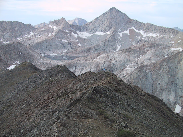
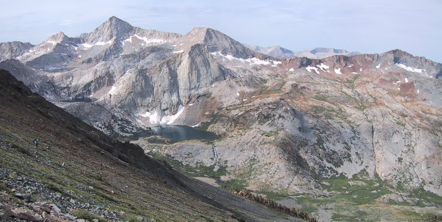
We got to Monarch Lakes and made camp behind the dam in a sandy spot, fired up the stoves, dried out the ponchos, watched the sun set. Temps did not get down to freezing - my cheap thermometer registered high 40F temps in the early morning. A nice breeze kept any condensation from forming in the tents. Next morning we started up by going down to the lower lake again, then up Sawtooth Pass. The trail over Sawtooth is not maintained and there are lots of use trails - the problem is, getting off the trail with a backpack is dangerous. The whole slope is loose decomposed granite and rocks ranging from baseball to Hummer sized, like so many other Sierra slopes... and I got off trail. First guy up, he is on the trail the whole way, cruising up so fast I lost sight of him in the boulder field and when I finally saw him again, I realized - I'm on some other stupid little footpath that promptly disappeared leaving me on a steep loose slope. Our tail end hiker, C, is making her way the best she can, on yet another dumb little footpath. D makes it to the top and yells, pointing, go that way, trail's over here. So we go. And we nearly fall a long way several times, it takes us an hour to go barely 1/4 mile across this slope... and then we find the trail. We zip up the rest of the way and traverse the length of the ridge to the pass. And that night I dreamed of the avalanche I almost rode to the bottom, a whole section of dirt and rock that started to slide down while I sank up to my knees.... Not something I will repeat especially now that we know where the trail goes! There are dayhikers that do that pass with nothing but a tiny pack and get to use hands and feet to scramble what we were sinking into and sliding down, but it is dangerous for them as well - if someone ahead of you dislodges a rock, and you are in the way.... Not a pass for folks prone to vertigo.
Dropping into Columbine Lake, we stopped for rain gear as more afternoon rain began - the sort that will soak your clothes in the ongoing gentle drizzle. Someone had hunkered down in a bare spot behind a huge boulder; I almost ran into his tent. We hiked on, determined to go below treeline and out of the wind, and hiked out of the rain as we once again found maintained trail down from Columbine to the valley beyond. Our second night we stayed at the junction of the Big Five Lakes trail and the Soda Creek trail. Rain drove us to bed early and some spotty sunshine in the morning (in five minute increments as clouds went by) was not enough to dry things out completely.
We spent our third day hiking along forested trail with a few views from the end of a ridge, heading up to Little Claire Lake on a long series of switchbacks giving us awesome views of peaks and lakes around us, then on to Forester Lake, dropping again to camp at the junction of Rattlesnake Creek and Soda Creek trails, positioning ourselves to head over Franklin Pass the following morning. It cleared enough that we had some great star watching opportunities. After we went to bed, the lightening started - up in the clouds that regathered and began to send down drops of rain every so often.
As we rose early and began to pack, snow began to fall. It didn't stick - it was graupel and we hardly felt it coming down, but it was impressive as little balls of ice bounced around and collected in piles. Packing up tents left tent-shaped bare spots. We headed up the pass and spooked a huge herd of mule deer from a meadow on the way up. Animals here are reassuringly shy and run off as we are approaching. On the pass itself the wind started again and clouds gathered and dispersed multiple times. I had a few moments on top before the chill drove me down again. We ran into a group of young men heading out, asking about the hail. We explained it was snow....
With one long break at Franklin Lakes we hurried down to the car through the clouds. We appeared to be above them for a long time - looking out across a field of clouds was pretty cool, getting down into them was chilly, and driving all the way out that narrow road in them, not fun since there seemed to be quite a few cars going in on a Monday and it's only one lane with blind curves. We saw two young bears on the way out - one sitting across the road from the Hockett trailhead parking, another outside the park as we made the final four miles descent into Three Rivers. Pizza had a rejuvenating effect on us - suddenly the tired nonverbal damp hikers once again became chatty and happily reminisced and joked about our adventure on the drive back to Fresno.
And so now I am home, laundry drying, gear drying, planning the next adventure....
Until I figure out how to link/post to individual pictures... the gallery is here.

The Moon is Waxing Gibbous (79% of Full)
Re: Mineral King loop (Sequoia NP)
All posts are those of the individual authors and the owner
of this site does not endorse them. Content should be considered opinion
and not fact until verified independently.
|
Mineral King loop (Sequoia NP) October 05, 2010 04:02PM | Registered: 14 years ago Posts: 923 |
October 05, 2010 09:00PM | Moderator Registered: 15 years ago Posts: 1,918 |
Thanks for this.
Mineral King has been on my list for a few years now... still haven't gotten there.
Was looking to do Sawtooth... Big Five - x to Little Five/Black Rock Pass then x
up back to Sawtooth via Cyclamen.
Every time I mention Kings I just get "wah... I want easy... wah... " ..
I think next year I'm just gonna have to use the "just lie" tactic.
"It's only a 1500 ft. climb" (you may have to do it a few times though)
Anyway, thanks for posting this.
(btw ... posted the wifey in the hammock in the snow just for you)
http://yosemitenews.info/forum/read.php?3,29009,29052#msg-29052
(that's a jacks 'r' better winter under blankie w/ clark ultralight hammock)
Mineral King has been on my list for a few years now... still haven't gotten there.
Was looking to do Sawtooth... Big Five - x to Little Five/Black Rock Pass then x
up back to Sawtooth via Cyclamen.
Every time I mention Kings I just get "wah... I want easy... wah... " ..
I think next year I'm just gonna have to use the "just lie" tactic.
"It's only a 1500 ft. climb"
(you may have to do it a few times though)Anyway, thanks for posting this.
(btw ... posted the wifey in the hammock in the snow just for you)
http://yosemitenews.info/forum/read.php?3,29009,29052#msg-29052
(that's a jacks 'r' better winter under blankie w/ clark ultralight hammock)
|
Re: Mineral King loop (Sequoia NP) October 05, 2010 09:17PM | Registered: 14 years ago Posts: 923 |
Quote
bill-e-g
Thanks for this.
Mineral King has been on my list for a few years now... still haven't gotten there.
Was looking to do Sawtooth... Big Five - x to Little Five/Black Rock Pass then x
up back to Sawtooth via Cyclamen.
Every time I mention Kings I just get "wah... I want easy... wah... " ..
I think next year I'm just gonna have to use the "just lie" tactic.
"It's only a 1500 ft. climb"
Anyway, thanks for posting this.
(btw ... posted the wifey in the hammock in the snow just for you)
http://yosemitenews.info/forum/read.php?3,29009,29052#msg-29052
(that's a jacks 'r' better winter under blankie w/ clark ultralight hammock)
We saw the Black Rock trail while we were on Sawtooth - oooooooooo, gives me the heebies looking at those trails sometimes, just a line on a vertical face. But a lot of the high passes are just a foot wide trail zigzagging down a rocky face and I really enjoyed the ones I've been on so far this year, Forester, New Army, Sawtooth, Franklin.... The thing I like about it - even tho the switchbacks make it a lot longer, you move so much faster on the nicely graded trail, it's not really terribly steep and you can just hike along looking at scenery. If you don't look down and freak out. It sure beats trying to boulder your way over.
Sawtooth is prolly easier going the other direction - the trail on the north/east side is much nicer, marked with (for once, useful, since it would be easy to get frustrated navigating around Columbine without them) very large ducks. From the top of Sawtooth you can see the use trails down the steeper south/west side - traverse right some, and there are some switchbacks going down.
I saw pika at Franklin Lakes. Maybe that would be an introductory hike - take her overnight to Franklin. Awesome sample of the typical Sequoia passes/Mineral King trails, and I bet she would be hooked. Tho you won't be able to hammock - there is a tent site below the dam with a bear box.
Very nice pic of the hammock - I plan to mush out on snowshoes and try me some winter action in my hammock too. Got a 0 degree quilt just waiting for the right occasion.
October 05, 2010 09:43PM | Admin Registered: 15 years ago Posts: 17,051 |
Quote
AlmostThere
But a lot of the high passes are just a foot wide trail zigzagging down a rocky face
Sometimes you get a food wide trail with down on both sides.
http://yosemitephotos.net/main.php/v/misc/sh-dscn5294.jpg.html
|
Re: Mineral King loop (Sequoia NP) October 05, 2010 10:06PM | Registered: 14 years ago Posts: 923 |
Quote
eeek
Quote
AlmostThere
But a lot of the high passes are just a foot wide trail zigzagging down a rocky face
Sometimes you get a food wide trail with down on both sides.
http://yosemitephotos.net/main.php/v/misc/sh-dscn5294.jpg.html
I like the way the trees appear to be crouching down to cling to the sides...
That pic plays funny with my vertigo issues... exposure! exposure!
October 06, 2010 01:24AM | Admin Registered: 15 years ago Posts: 17,051 |
|
Re: Mineral King loop (Sequoia NP) October 06, 2010 07:34AM | Registered: 14 years ago Posts: 923 |
Quote
eeek
Quote
AlmostThere
I like the way the trees appear to be crouching down to cling to the sides...
That's from the wind.Quote
That pic plays funny with my vertigo issues... exposure! exposure!
It didn't feel all that bad to me. But I wouldn't want to stumble and go over the side.
Yes, I understand windswept trees... seen a lot of them... wind does interesting things to all kinds of land features, and to clouds. Sorry, wasn't aware my poetic license was expired... how much is the ticket?
Stumbling is precisely my concern. I keep going to precarious places in spite of my feet's habits of finding the wrong spot to land.
October 07, 2010 02:01AM | Admin Registered: 15 years ago Posts: 17,051 |
October 06, 2010 06:59AM | Moderator Registered: 15 years ago Posts: 1,918 |
 :
:
|
Re: Mineral King loop (Sequoia NP) October 06, 2010 07:36AM | Registered: 14 years ago Posts: 923 |
October 06, 2010 10:03AM | Registered: 13 years ago Posts: 185 |
Did the Timber Gap -> Black Rock Pass -> Sawtooth Loop in August. Awesome trip. Not doing the Timber Gap/Cliff creek thing again (would use Glacier Pass) but I actually liked black Rock. It's steep and dry but the views are great and it's got a lot of little details that make it continuously interesting.
My trip report
I love Columbine Lake - the fishing is great.

My trip report
I love Columbine Lake - the fishing is great.
October 06, 2010 12:13PM | Moderator Registered: 15 years ago Posts: 1,918 |
Nice. Thanks for that.
Loved your "End of Summer Reflections", especially the second paragraph.
I'd add it feels more like an adventure when you're making your own route too.
Been piecing together a huge completely off trail foray circle w/i Yosemite.
Hetch Hetchy is a big obstacle though... not sure I want to relive the
vaunted Goat Gluch down into Poopenaut again... probably gonna have to
get on the trail at that pt.
Have fun
Sorry, only registered users may post in this forum.

