All posts are those of the individual authors and the owner of this site does not endorse them. Content should be considered opinion and not fact until verified independently.

Phantom Valley, Tree Chute, Taft Chute, and the GP Waterworks (long)
October 20, 2010 09:15PM
tanngrisnir3 wrote:
I've always been interested in Tree Chute (and how navigable it is) and Phantom Valley, esp. in regards to pics.


*******************
OK. It's time to wrap up the other south side hikes from my list of off-trail stuff around Yosemite Valley. See thread: Off-Trail Thread

This group of hikes would be #23-26 on my list.


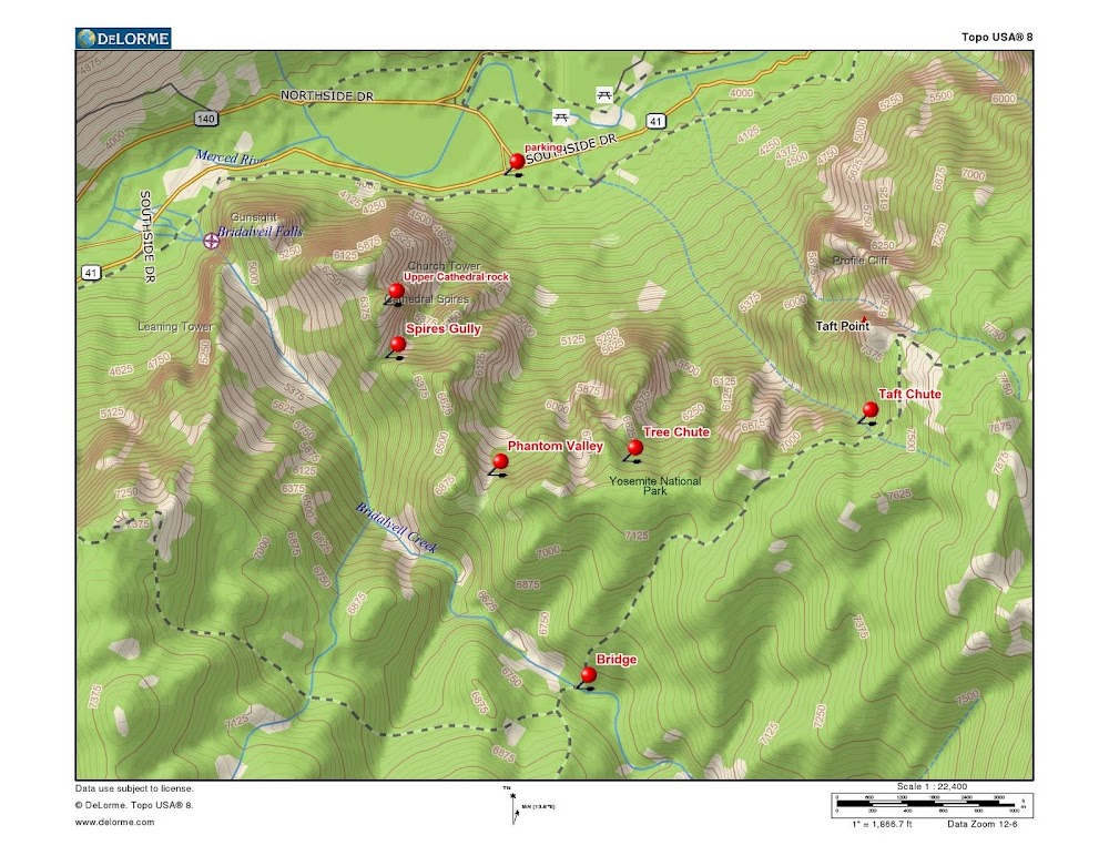
I talked about Cathedral Spires Gully in my previous post.

Phantom Valley

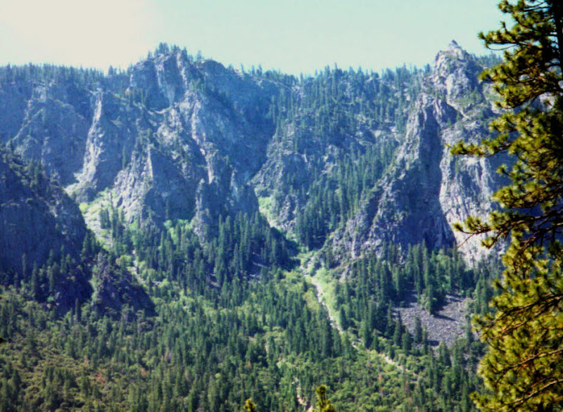
Phantom Valley is named for the Phantom Pinnacle climb, which is on the large rock outcrop to the west, between it and the Cathedral Spires. The valley is a large, open area with its principle upper exit on the east side, but you can also exit to the west by angling that way after passing an outcrop. See photo.


This is a view from Indian Canyon of the route. You can see that there must snow slides on rare occasions, to keep the forest from growing up, but I have never seen any slide debris there. Because the brush changes from year to year, I can't give specific directions for the easiest route. It's all doable. I usually prefer to do this one going downhill, after entering from McGurk Meadow or one of the other chutes. You cannot get lost once you get into this chute. Coming up from the bottom, just follow the banks of the small creek that drains it, which crosses the valley foot trail at approximately N37.72 W119.6255 From the top, finding the entry is no problem because you can see the whole route below you as you approach along the ridge from the east. (The entry is at about N37.704 W119.63)
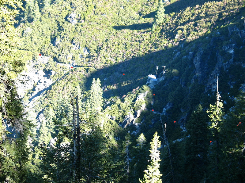
Tree Chute

This is my favorite of the ones in this note. It's just another of those neat routes that are so much easier to do than you might think from a distance.


The photo above is of terrible quality, but because it is taken from Manure pile buttress it gives a view that clearly shows that Tree Chute and Taft Chute have separate exit creeks all the way to the highway. Some maps show them merging, which is misleading because if you are entering from below you have to choose the right creek to follow. The creek from Tree Chute swings to the west as it exits the steep part. Tree Chute has a right angle bend in the middle. The dots in the following photo show the Tree Chute route, the stars show Taft Chute:


Ascending from below, it is impossible to get lost, if you pick the right creek to go up and have enough sense to make the turn at the right angle bend. You can't see it in this photo, but above the bend the chute opens into a wide funnel with the easiest exit along the right side (behind that rib of rock). There are some rock ledges at the intersection which are most easily passed on the (left) uphill side. After a big snow year, there will be a pile of lumber and debris at this point, left over from avalanches that couldn't negotiate the bend.

If you do this as a descent, there will be no route finding problem if you just manage to enter the right chute. Needless to say, there are a lot of wrong chutes here in the vicinity of Taft Point. This one is entered at approximately N37.705 W119.621 Remember, you should never go down anything that you can't easily go back up....

Taft Chute

This is the starred route in the photo above. It's very straightforward. I've only done it once, going downhill. That is because it is too straightforward and has no interesting route finding problems to solve. A simple straight avalanche chute that looks like it runs every year. Walk on the banks of the creek where you can, and in the gravel and talus of the (dry) creek where you can't. From above, leave the Pohono Trail and go down the prominent gully just west of Taft Point. There are no cliffs or ledges to negotiate.

The only memorable moment came from seeing the consternation of the tourists on Taft Point when I led my daughter off the trail and down to our certain deaths in the cliffs below....

Did I mention that I always carry a rope and descending gear when I poke around these things for the first time? I've never had to use them though. And it's never an issue if you do them from the bottom....

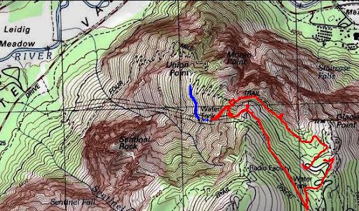
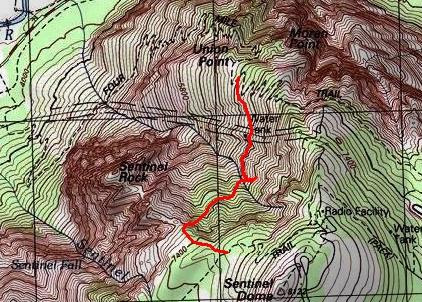
Glacier Point Water Works

The waterworks were well introduced in a previous thread about Union Point: Anderson Trail thread

This bushwhack runs from Union Point on the Four Mile Trail to the base of Sentinel Dome, reaching it at a saddle where a ridge runs out to Sentinel Rock. From Union Point, first proceed onto the first switchback to the left. As you ascend, watch for the service trail branching off on the right. There will be two, the unobvious real one and a larger dummy entrance that takes you up to the left and then peters out. Take the service trail and continue on to the pump house and storage tank. Then follow the large plastic feed pipe downhill to the older ledge that traverses west (the ledge that was a gravity feed to Union Point) and then along that pipe up the next creek to the small concrete tank that contains the spring.

From there, climb the bank to the right. The first few steps out of the creek bed require some searching, but after that you are in steep grove of trees. Ascend upwards and to the right. As you approach the base of the cliffs at the top of this amphitheater, you will see a miraculous break exactly at the inside corner between those cliffs and the ones on the ridge coming in from the right from Sentinel Rock. Easy steep dirt the whole way. You will exit at the saddle, and pick up the climbers trail over to the Pohono Trail, which is a short distance above you.

Here is a photo taken from the Sentinel Ridge, which shows the waterworks from another side:


You can see the service trail, the steep descent alongside the feed pipe from the tank to the old ledge (Do NOT touch the pipe, even though this place has some steep and loose gravel. The pipe is plastic and the rangers will skin you if you hurt it), along the ledge, and then along the pipe up to the spring.


Edited 1 time(s). Last edit at 10/21/2010 10:48AM by szalkowski.
avatar Re: Phantom Valley, Tree Chute, Taft Chute, and the GP Waterworks (long)
October 21, 2010 07:30AM
Regarding GP ww... I guess you meant "From Union Pt." not Taft.
Interesting about the plastic pipe. It's definitely metal above the tank.
Hiked down approx 300. above it from above. it's nice and steep.
Didn't realize was so "close" otherwise woulda continued... o well..

Pretty sure this is the route. The blue is drawn in... the red is GPS tracks.


Edited 1 time(s). Last edit at 10/21/2010 04:23PM by bill-e-g.
Re: Phantom Valley, Tree Chute, Taft Chute, and the GP Waterworks (long)
October 21, 2010 10:10AM
Sorry. Yes, the second sentence under "Glacier Point Waterworks" should say "Union Point". If you can fix that, please do.

It would have to be metal pipe above the pump house. The pressure from a head of over 800 feet is on the order of 400 psi. That's about five times what you probably have in your pipes at home. I wouldn't expect plastic pipe sitting out in the sun for years at a time to hold up to that...

You did well. That hillside looks plenty steep from below....
Re: Phantom Valley, Tree Chute, Taft Chute, and the GP Waterworks (long)
October 21, 2010 02:29PM
I may check that out if conditions prove too wet or dangerous for the El Cap gully over Halloween weekend.

All these years and I had ZERO idea that that water works/treatment plant/whatever is up there.

Oh, and do you have any pics of the view across, taken from the waterworks?


Edited 1 time(s). Last edit at 10/21/2010 02:32PM by tanngrisnir3.
Re: Phantom Valley, Tree Chute, Taft Chute, and the GP Waterworks (long)
October 21, 2010 04:25PM
Quote
tanngrisnir3

Oh, and do you have any pics of the view across, taken from the waterworks?

Not really. All the distant views are better had from the Four Mile Trail, Pohono Trail, or from Sentinel Dome...
Re: Phantom Valley, Tree Chute, Taft Chute, and the GP Waterworks (long)
October 22, 2010 09:00AM
Thanks wherever for this post. I am looking for cool hikes to do this winter in the valley.
Re: Phantom Valley, Tree Chute, Taft Chute, and the GP Waterworks (long)
October 22, 2010 10:18AM
I don't know how safe this one would be in winter. Even if there is no snow on the valley floor, or up this chute, there will be snow on top, which on a sunny day, could slide down without much notice.

Comments?
Re: Phantom Valley, Tree Chute, Taft Chute, and the GP Waterworks (long)
October 22, 2010 12:23PM
Oh, thanks hotrod4x5...good point. It would be cool if someone could reply or start a new thread about recommended hikes in the valley during the winter.
Re: Phantom Valley, Tree Chute, Taft Chute, and the GP Waterworks (long)
October 22, 2010 07:04PM
Quote
hotrod4x5
I don't know how safe this one would be in winter. Even if there is no snow on the valley floor, or up this chute, there will be snow on top, which on a sunny day, could slide down without much notice.

Comments?

Actually, you have it backwards. The top is often sunny and therefore snow-free in the early and late winter, but the chutes hold snow for a long time. They get very little sunshine, which is why it's so hard to find good photos of them.

I originally got interested in Tree Chute and Taft Cute from the entries about them in the book on skiing the Yosemite chutes. Until then, I didn't realize that they are among the few that lack cliffs and waterfalls...
avatar Re: Phantom Valley, Tree Chute, Taft Chute, and the GP Waterworks (long)
October 22, 2010 04:49PM
Quote
tanngrisnir3
All these years and I had ZERO idea that that water works/treatment plant/whatever is up there.


One would surmise that the spring feeding it was the main source of water for the Glacier Point Hotel/Mountain House 'complex' which burned to the ground in 1969.
(Presumably to the dismay of all the four-footed creatures that called it home. My first visit to Glacier Point was 1-2 months before the fire and I can personally attest that, at that time, "Rattrap" was a more appropriate description than "Hotel". ).

It may have also supplied water to a campground which once existed E of the road between Washburn Point and Glacier Point.
(I have a 1958 topographic map (Lim. Rev. 1970) of the area which shows a campground about 0.3 mi. S of the uppermost water tank.)

Perhaps wherever can comment on the above assumptions.


Edited 1 time(s). Last edit at 10/22/2010 04:50PM by szalkowski.
Re: Phantom Valley, Tree Chute, Taft Chute, and the GP Waterworks (long)
October 22, 2010 06:58PM
Quote
szalkowski

One would surmise that the spring feeding it was the main source of water for the Glacier Point Hotel/Mountain House 'complex' which burned to the ground in 1969.
(Presumably to the dismay of all the four-footed creatures that called it home. My first visit to Glacier Point was 1-2 months before the fire and I can personally attest that, at that time, "Rattrap" was a more appropriate description than "Hotel". ).

It may have also supplied water to a campground which once existed E of the road between Washburn Point and Glacier Point.
(I have a 1958 topographic map (Lim. Rev. 1970) of the area which shows a campground about 0.3 mi. S of the uppermost water tank.)

Perhaps wherever can comment on the above assumptions.

Those are my assumptions, too. However, all that I have been able to find in books is the fact of the Union Point drinking fountain and watering trough upgrade in 1932. So that part of the system existed at that time, but it didn't need a pump. I agree that the hotel must have been serviced by the pump house, and probably the campground and Glacier Point parking lot fountain were, too. We need to hear from one of the old timers who remember that era.
Re: Phantom Valley, Tree Chute, Taft Chute, and the GP Waterworks (long)
October 23, 2010 09:08AM
So, last question, am I to understand correctly that the waterworks is now fully derelict, or does it have some sort of continued function?
avatar Re: Phantom Valley, Tree Chute, Taft Chute, and the GP Waterworks (long)
October 23, 2010 11:28AM
Quote
tanngrisnir3
So, last question, am I to understand correctly that the waterworks is now fully derelict, or does it have some sort of continued function?


I suspect, especially in light of wherever's comment re. people-skinning rangers, that it is still merrily functioning as the water source for the facilities at Glacier Point proper as well as a couple NPS cabins that exist in the vicinity of the old campground.
avatar Re: Phantom Valley, Tree Chute, Taft Chute, and the GP Waterworks (long)
October 23, 2010 03:12PM
It's still in use. If you look at the topo map above you see the tank at GP.
The other link I put a pict. of the metal pipe above the second tank.
All in good working order...

Sort of confused by some of the other statement/assumptions. Fairly certain
they are pumping water up to the tank above Glacer Pt. from the Merced.
Re: Phantom Valley, Tree Chute, Taft Chute, and the GP Waterworks (long)
October 23, 2010 04:01PM
Quote
bill-e-g
It's still in use. If you look at the topo map above you see the tank at GP.
The other link I put a pict. of the metal pipe above the second tank.
All in good working order...

Sort of confused by some of the other statement/assumptions. Fairly certain
they are pumping water up to the tank above Glacer Pt. from the Merced.

OK. Perhaps I was too obscure. The system is still in use. You can sometimes hear the pump running, and they drain it every winter to keep the pipes from freezing and bursting. It does feed the tank up on the ridge and is used up there for whatever they want: fire fighting, fountains, snack bar...

The other speculation all had to do with history. How could they have used the wooden pipes (won't withstand much pressure), the purpose of the now unused and overgrown ledge that went to Union Point (below the current access trail), whether the pump system is old enough to have serviced the hotel and campground or is newer than that. None of that musing affects the hike or the function of the current water works.
avatar Re: Phantom Valley, Tree Chute, Taft Chute, and the GP Waterworks (long)
October 23, 2010 05:09PM
Are you sure about wooden pipe not withstanding pressure?

http://www.sewerhistory.org/grfx/components/pipe-wood1.htm

I think I saw something about HH using wooden pipes at one time too.

Here's a map of GP Hotel:
http://www.yosemite.ca.us/library/yosemite_resources/mather_years.html#page_648
avatar Re: Phantom Valley, Tree Chute, Taft Chute, and the GP Waterworks (long)
October 23, 2010 05:15PM
Totally unrelated other than it has "GP Hotel" on it:
http://www.yosemite.ca.us/library/yosemite_resources/images/illustration_139.png

Love the "Bear Feed Platforms" on Cathedral Rocks Road
avatar Re: Phantom Valley, Tree Chute, Taft Chute, and the GP Waterworks (long)
October 24, 2010 08:06AM
Quote
bill-e-g
Totally unrelated other than it has "GP Hotel" on it:
http://www.yosemite.ca.us/library/yosemite_resources/images/illustration_139.png

Love the "Bear Feed Platforms" on Cathedral Rocks Road


Note the hourly traffic protocol on Big Oak Flat Road.
Re: Phantom Valley, Tree Chute, Taft Chute, and the GP Waterworks (long)
October 23, 2010 06:22PM
Quote
bill-e-g
Are you sure about wooden pipe not withstanding pressure?

http://www.sewerhistory.org/grfx/components/pipe-wood1.htm

I think I saw something about HH using wooden pipes at one time too.

Here's a map of GP Hotel:
http://www.yosemite.ca.us/library/yosemite_resources/mather_years.html#page_648

Nice references. Thanks.

Of course a new wooden pipe can withstand pressure, though the joints can have a sealing problem. However, if you are the guy who has to do the maintenance, you will always choose to lay it with an unpressurized gravity route if you can. Ceramic sewer lines are usually laid the same way (with simple overlapping joints and downhill runs), though the big mains are built to a much higher standard...
avatar Re: Phantom Valley, Tree Chute, Taft Chute, and the GP Waterworks (long)
October 23, 2010 06:31PM
Ah yes. The plumbers credo: Shit runs downhill and payday is on Friday.


Old Dude
avatar Re: Phantom Valley, Tree Chute, Taft Chute, and the GP Waterworks (long)
October 17, 2011 07:40AM
The pipe to the spring/small dam is busted up in a zillion places now.
The tank was empty too. There was a post a bit ago about work at GP
w/r to the tanks up there and possibly making this works area obsolete.
That appears to be that case.


Chick-on is looking at you!
Re: Phantom Valley, Tree Chute, Taft Chute, and the GP Waterworks (long)
October 17, 2011 07:56AM
Quote
chick-on
The pipe to the spring/small dam is busted up in a zillion places now.
The tank was empty too. There was a post a bit ago about work at GP
w/r to the tanks up there and possibly making this works area obsolete.
That appears to be that case.

What a shame. Did you try the hike from there up to Sentinel Dome? With the water works gone, the trail to that area will quickly become impassable from brush, like the old gravity feed route to Union Point has become.
avatar Re: Phantom Valley, Tree Chute, Taft Chute, and the GP Waterworks (long)
October 17, 2011 08:06AM
Quote
wherever
What a shame. Did you try the hike from there up to Sentinel Dome? With the water works gone, the trail to that area will quickly become impassable from brush, like the old gravity feed route to Union Point has become.
The trail is in good shape now. And there are lopers in the building if you
ever want to do some maintenance. I went almost due east to the
south of Sentinel Rock. The final stretch I ended up pulling some class 4
maneuvers to get all the way up. As you mention it's steep but you can
stay in trees and use game trails to get up... no rock work is really
required. Next time I will do that...The area south of Sentinel rock is yet
another place where the trail has been rerouted... and not for the better.
Some great views are missed by that realignment.


Chick-on is looking at you!
Re: Phantom Valley, Tree Chute, Taft Chute, and the GP Waterworks (long)
October 17, 2011 05:07PM
Quote
chick-on
Quote
wherever
What a shame. Did you try the hike from there up to Sentinel Dome? With the water works gone, the trail to that area will quickly become impassable from brush, like the old gravity feed route to Union Point has become.
The trail is in good shape now. And there are lopers in the building if you
ever want to do some maintenance. I went almost due east to the
south of Sentinel Rock. The final stretch I ended up pulling some class 4
maneuvers to get all the way up. As you mention it's steep but you can
stay in trees and use game trails to get up... no rock work is really
required. Next time I will do that...The area south of Sentinel rock is yet
another place where the trail has been rerouted... and not for the better.
Some great views are missed by that realignment.

Thanks for the info. But I am somewhat confused by the report. South of Sentinel Rock is Sentinel Dome. You can't get there by going east. Anyway, we agree, that from the end of the plastic pipes, at the spring where the waterworks got its water, you can go diagonally up to the right with no rock work required, and come out at the trail along the base of the dome.

You could also go straight west from the spring towards the ridge behind Sentinel Rock. I tried it once, but backed off fifty feet or so before reaching the top of the rock ridge, because I don't do that stuff unroped when I am alone. It's fun enough just to explore the steep dirt in the trees.

The other confusion. You can't mean the regular dictionary definition of loper, meaning one with a steady, easy gait. The slang dictionaries aren't much better:
1. Someone suffering, by no fault of his own, from male pattern baldness.
2. A person who you are hooking up with or flirting with unbeknownst to the general public/your friends.
3. Someone who is chill and just lopes it hard. A loper can also be a party with strickly the bros and the danks..
4. Someone who lives, or was born in, Michigan's Lower Penninsula. The opposite of Yooper.

Still confused.
avatar Re: Phantom Valley, Tree Chute, Taft Chute, and the GP Waterworks (long)
October 17, 2011 05:21PM
Quote
wherever
The other confusion. You can't mean the regular dictionary definition of loper, meaning one with a steady, easy gait. The slang dictionaries aren't much better:
1. Someone suffering, by no fault of his own, from male pattern baldness.
2. A person who you are hooking up with or flirting with unbeknownst to the general public/your friends.
3. Someone who is chill and just lopes it hard. A loper can also be a party with strickly the bros and the danks..
4. Someone who lives, or was born in, Michigan's Lower Penninsula. The opposite of Yooper.

Still confused.


Chikinese for lopper:
http://en.wikipedia.org/wiki/Loppers
avatar Re: Phantom Valley, Tree Chute, Taft Chute, and the GP Waterworks (long)
October 17, 2011 08:23PM
Of course you can't. I meant the other east. (I do this too often, mean west, write east).
Argh!

GPS route:


Chick-on is looking at you!
avatar Re: Phantom Valley, Tree Chute, Taft Chute, and the GP Waterworks (long)
October 17, 2011 10:31PM
I remember that trail.

If you're on Pohono heading east, right after you cross Sentinel Creek you can head left out to the slopes looking directly out on the valley and Sentinel Rock, or go straight and go through a section of forest. I usually head left even though it doesn't appear to the be official trail! Who wants to look at a bunch of trees when you could be looking down at Sentinel Rock and Yosemite Valley! Either way works though, they hook up together within a short distance on the north side of Sentinel Dome.
Re: Phantom Valley, Tree Chute, Taft Chute, and the GP Waterworks (long)
October 17, 2011 08:48PM
Quote
chick-on
The area south of Sentinel rock is yet
another place where the trail has been rerouted... and not for the better.
Some great views are missed by that realignment.

Are you talking about the Pohono trail? I recall a use/climber trail just north of the Sentinel Creek crossing that stayed much closer to the edge of the valley than the current trail and thus had good views. It's from this trail (which I accidentally ended up on) that I first saw the GP waterworks.
avatar Re: Phantom Valley, Tree Chute, Taft Chute, and the GP Waterworks (long)
October 17, 2011 08:58PM
Yes, I recall seeing this trail on a map somewhere... if I find it I will post it.
I could be imagining things and have things turned east/west in my brain though
and it could be only a climber/abuse trail... well worth taking regardless.


Chick-on is looking at you!
Sorry, only registered users may post in this forum.

Click here to login