So I got lost on that old road once, I stayed on when I should have moved to the Pohono trail. But looking back, it's actually quite nice and I might want to actually plan to do that trip in the future. What I'm thinking is to actually get up to the peak of the hill once I get around and see the view down to the other side. But It was very dry in October, is there running water anywhere around there around June?
It might be cool to spend a day on the south side, camp at the peak, then move down to the glacier point area, or even just stay farther south as we move east. I haven't spent any time in the south.

The Moon is Waxing Gibbous (75% of Full)
Re: Old Road from Inspiration Point
All posts are those of the individual authors and the owner
of this site does not endorse them. Content should be considered opinion
and not fact until verified independently.
|
Old Road from Inspiration Point November 08, 2010 11:31AM | Registered: 13 years ago Posts: 14 |
|
Re: Old Road from Inspiration Point November 08, 2010 12:57PM | Registered: 14 years ago Posts: 755 |
Quote
ThaFlash_LA
So I got lost on that old road once, I stayed on when I should have moved to the Pohono trail. But looking back, it's actually quite nice and I might want to actually plan to do that trip in the future. What I'm thinking is to actually get up to the peak of the hill once I get around and see the view down to the other side. But It was very dry in October, is there running water anywhere around there around June?
It might be cool to spend a day on the south side, camp at the peak, then move down to the glacier point area, or even just stay farther south as we move east. I haven't spent any time in the south.
I'm not sure what you mean. If you proceed on the old road west past (New) Inspiration Point, missing the left turn onto the Pohono Trail, you then proceed on a rather overgrown track above Turtle Dome and continue west to meet up with the new Wawona Road somewhere near Avalanche Creek. I don't recall much in the way of lookouts to the west or south, other than what you already get from Turtle Dome and the new road.
Or do you mean that you want to take the Pohono Trail from Inspiration Point? If so, you won't get any view to the south until you get to Sentinel Dome.
Or do you mean that you want the view up Bridalveil Creek from Dewey Point?
November 08, 2010 01:46PM | Moderator Registered: 15 years ago Posts: 1,918 |
I put some comments here regarding that old road too:
http://yosemitenews.info/forum/read.php?3,29205,29713#msg-29713
You can whack your way to Turtleback from there too... but I can say the wife
complained quite a bit... and she's done quite a bit of xcountry with me...
There's decent views as you head off the road towards Turtle w/o going all the
way to Turtle...
|
Re: Old Road from Inspiration Point November 09, 2010 08:58AM | Registered: 13 years ago Posts: 14 |
I was on that road before and for some reason didn't turn left at the Pohono trail at New Inspiration Point.
I remember the road turning south, then starting to head east, right around there we diverted so I've never taken it far. I started heading North, once I figured out where I was, and it was actually pretty nice.
Looking at Google maps I can see that the road does head down to wawona now, we just diverted before. So I guess my plan would be way more of a X-Country trip.
This is where we took a break before heading down the north side of the hill to get back to inspiration point.
http://maps.google.com/maps?f=d&source=s_d&saddr=Yosemite+National+Park,+CA+95389+(Yosemite+National+Park)&daddr=37.699412,-119.688245&hl=en&geocode=CdNYJt-y7fStFWRVQAIdDWng-CH-A4DtLJwkLQ%3B&mra=mift&mrsp=1&sz=18&sll=37.699348,-119.687837&sspn=0.002806,0.005477&ie=UTF8&ll=37.699297,-119.687837&spn=0.002912,0.005477&t=h&z=18
I'm thinking that it might be nice to do that travel again and just take it east until we link back up with a trail.
November 10, 2010 07:31AM | Moderator Registered: 15 years ago Posts: 1,918 |
Sounds fun. A worthy endeavor imo is to continue along the ridge there
(there's open granite in that area) and hook up with the intermediate
snow shoe trail that heads to Dewey.
Looks like you were off the road on your waypoint. Here's a map from 1910
with the road the way it used to be. We have only followed it a little bit
past Ft. Monroe... so if it really was a road still all the way to your waypoint
can you tell me please. (it would surprise me btw)
Here's the map:
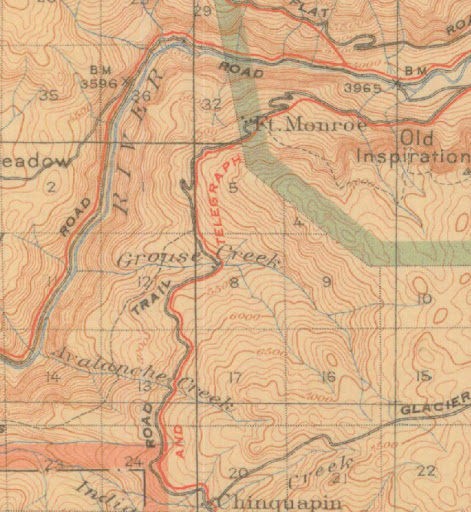
Your waypoint is b/t 4 and 5 on the map almost right on the yosemite grant boundary.
(there's open granite in that area) and hook up with the intermediate
snow shoe trail that heads to Dewey.
Looks like you were off the road on your waypoint. Here's a map from 1910
with the road the way it used to be. We have only followed it a little bit
past Ft. Monroe... so if it really was a road still all the way to your waypoint
can you tell me please. (it would surprise me btw)
Here's the map:
Your waypoint is b/t 4 and 5 on the map almost right on the yosemite grant boundary.
|
Re: Old Road from Inspiration Point November 19, 2010 12:41AM | Registered: 15 years ago Posts: 141 |
November 19, 2010 07:26AM | Moderator Registered: 15 years ago Posts: 1,918 |
Quote
Dearborn
By chance, do you have any recent images of the old Wawona Road and the Fort Monroe area? I always wanted to hike the old road, but never took the time before I moved to the Yellowstone area.
This is the best I can do for you:
http://picasaweb.google.com/yosemite.chick.on/OldWawonaRd
Somehow I don't even have a photo of "Ft. Monroe". Why? Hmm... well...
it's not a "fort" to start with... it was at one point a "station" along
Wawona Rd... although I haven't been able to find any remnants of
structures... and it's not all that .. uh... impressive...
just a "small" area that is like a million other areas in Yosemite ...
You'd walk right by it without batting an eye.
The most interesting thing near the road is an old water trough. I've
included 3 photos of it in various "states"

Need to go back to Ft. Monroe again to look more... maybe next year...
Enjoy
Edited 1 time(s). Last edit at 11/19/2010 07:39AM by bill-e-g.
|
Re: Old Road from Inspiration Point November 19, 2010 11:17AM | Registered: 14 years ago Posts: 755 |
Great photos. Thanks.
About Fort Monroe: The name was a bit of a joke. Monroe was a popular negro stage driver on the line at the time it was being built as a private toll road.
from Wikisource: The company maintained a series of stations on the road for servicing the stages; these were spaced at roughly 4-mile intervals. Within the present park boundaries, the stations were Four Mile Station (the point from which the branch line to the Big Tree Grove departed), Wawona, Alder Creek, Eight Mile station, Eleven Mile Station (sometimes called "West Woods" , Chinquapin Flat, Grouse Creek and Fort Monroe. Each station had a water source, stables, corral, and a cabin for the keeper. The company ran 6-horse stages at first, later switching to lighter 4-horse rigs. A snow plow was placed in service on the road in April 1876.
See link: Wawona Road
At that time, the park boundaries were such that Wawona and Chinquapin were in private hands, and Ft. Monroe was the south entrance station for the Valley. It was also at the junction between the Wawona Road and the Pohono Trail (That trail has since been routed closer to Inspiration Point, and now includes the remaining part of the old road going down to the Valley. It formerly ended at Fort Monroe). So the "fort" part of the name may have been to twit the government agent at the entrance checkpoint.
One reason that no one hikes the abandoned part of the road west of Ft. Monroe is that it doesn't go up the hill to Cinquapin. Too much granite up there. It took a big switchback down the ridge west of Turtle Dome and thence to a flat spot at Grouse Creek. So you would lose a bit of elevation, and hit the current road near Grouse Creek. See Bill-e-g's map above.
There was also an earlier cabin in the area built by Henry Wilmer and called the Hermitage, which some maps place just above Ft. Monroe and some place at Grouse Creek. It was a major landmark for fifty years or so.
About Fort Monroe: The name was a bit of a joke. Monroe was a popular negro stage driver on the line at the time it was being built as a private toll road.
from Wikisource: The company maintained a series of stations on the road for servicing the stages; these were spaced at roughly 4-mile intervals. Within the present park boundaries, the stations were Four Mile Station (the point from which the branch line to the Big Tree Grove departed), Wawona, Alder Creek, Eight Mile station, Eleven Mile Station (sometimes called "West Woods"
, Chinquapin Flat, Grouse Creek and Fort Monroe. Each station had a water source, stables, corral, and a cabin for the keeper. The company ran 6-horse stages at first, later switching to lighter 4-horse rigs. A snow plow was placed in service on the road in April 1876.See link: Wawona Road
At that time, the park boundaries were such that Wawona and Chinquapin were in private hands, and Ft. Monroe was the south entrance station for the Valley. It was also at the junction between the Wawona Road and the Pohono Trail (That trail has since been routed closer to Inspiration Point, and now includes the remaining part of the old road going down to the Valley. It formerly ended at Fort Monroe). So the "fort" part of the name may have been to twit the government agent at the entrance checkpoint.
One reason that no one hikes the abandoned part of the road west of Ft. Monroe is that it doesn't go up the hill to Cinquapin. Too much granite up there. It took a big switchback down the ridge west of Turtle Dome and thence to a flat spot at Grouse Creek. So you would lose a bit of elevation, and hit the current road near Grouse Creek. See Bill-e-g's map above.
There was also an earlier cabin in the area built by Henry Wilmer and called the Hermitage, which some maps place just above Ft. Monroe and some place at Grouse Creek. It was a major landmark for fifty years or so.
|
Re: Old Road from Inspiration Point November 10, 2010 12:06PM | Registered: 13 years ago Posts: 14 |
It was a road, but it got way overgrown after the Ft. Monroe area. I think we were a bit south of the 5 on the road when we started to turn up the mountain. On my waypoint we were off the road, we had climbed to the top to get a better bead on where we were.
There were trees coming through the road and the point where we started to go up the mountain was a spot where a rather large tree that was growing out of the road had fallen over. At that point it looked like the pavement ended.
Taking a trail down to Dewey would be pretty nice, that trip would be just about the most scenic I could think of in that area.
|
Re: Old Road from Inspiration Point November 27, 2010 12:00AM | Registered: 15 years ago Posts: 141 |
I thank you for the link to the pictures. I wrote my BA thesis on the development of transportation in Yosemite in 1971, and walked many parts of the old Wawona stage road, but not that portion. I also forwarded the link for the photos to a Wawona resident whose family has been in and around Yosemite since 1855. His grandfather and great-grandfather were stagedrivers on that very road, and I wish some of their experiences could be published.
Your neat map also displayed a foot trail that ran from the Grouse Creek area to El Portal. I always wanted to hike that trail, but never found the time.
Your neat map also displayed a foot trail that ran from the Grouse Creek area to El Portal. I always wanted to hike that trail, but never found the time.
November 30, 2010 05:07PM | Registered: 14 years ago Posts: 7,421 |

Sorry, only registered users may post in this forum.

