Afternoon all,
One glance and I new I had to join! A good amount of knowledge bouncing around here.
I will be attempting the SHR starting September 1st 2011 north to Tuolumne Meadows and then follow the Tahoe Yosemite Trail home to Lake Tahoe.
Duration 30 to 45 days weather permiting (here's to HOPE)
Kings Canyon - Puite Pass - Bishop 7 Days resupply in Bishop
Piute Pass - Red's Meadow 7 Days resupply at Red's Meadow (Mammoth if Red's is closed)
Red's Meadow - Tuolumne Meadows 7 Days resupply at Tuolumne Meadows (Lee Vinning if Tuolumne is closed)
Tuolumne Meadows - Kennedy Meadows 7 Days resupply at Kennedy Meadows (Sonora if Kennedy Meadows is closed)
Kennedy Meados to Lake Tahoe 10 days
I will be attempting to cover 10+- miles a day
Base weight 13 pounds
2 pounds per day of food (I add Hammer Nutrion to my diet for performance)
Bear Vault 450 for the Bears/RANGERS with an Ursack for overflow.
Wow that was a mouth full.... So what I'm looking for is any hints/advice/opinions/ect.
A couple of issues/concerns late season + high country, might = ?snow? I will have to do my home work and find exit pass's if it hits the fan.
The resuplly points most likely will be closed as the hike goes on...
All posts are those of the individual authors and the owner
of this site does not endorse them. Content should be considered opinion
and not fact until verified independently.
|
SHR north to Tuolumne, north along Tahoe Yosemite Trail January 11, 2011 02:30PM | Registered: 13 years ago Posts: 4 |
|
Re: SHR north to Tuolumne, north along Tahoe Yosemite Trail January 11, 2011 05:41PM | Registered: 15 years ago Posts: 9 |
I have the hiked the SHR north to TM and it is a heck of a trip. We did about 15 miles/day which is roughly half my normal trail mileage. We had intended on hiking all the way to the end in ten days but frankly doing 4 12k passes in a day burned us out and we stopped at Reds early. Also, I was pretty sick of crossing endless talus fields. SO.... there are many options that allow you to have a trail alternate to save time. A good example is hiking the JMT from Thousand Island instead of the SHR. It would save a day if you get behind.
We didn't carry a bear canister in Kings, they are not required anywhere on the SHR. However, we had two strategically placed canisters placed on the route for our resupply. If I were hiking your route I would do a Ursack and then hike the Yosemite section in a day and pick up the canister in TM. This is exactly what I did when I did the Thousand Island to TM section.
I think you will be OK will the resupplies at TM and Reds. I believe the stores were open until late Sep last year.
Sounds like a great trip. One question.... Why the Yosemite-Tahoe trip with tjhe High Route instead of a JMT/SHR combo?
|
Re: SHR north to Tuolumne, north along Tahoe Yosemite Trail January 12, 2011 09:47AM | Registered: 13 years ago Posts: 4 |
Thanks for the input GGman,
The resupply issue seems to be the one that is most concerning right now. You've got a point with the bear can, but I would need it in N. Yosemite. Maybe I will hike my bear can in at Piute Pass and use my ursack for the first week. Saves the 'light' 2pounds 2ounces of my back for the first section. Most of the resupply locations are closed for the season which is a planning issue, only patience and time will solve that.
The reason why I'm not doing a SHR/JMT combo is because in August my girlfriend and I will be doing the JMT. When she picked me up in Lone Pine last Sept after thru hiking the JMT she could not resist the need to see the High Sierra! Cant agree more.
On a side note I just put together three mostly off trail hikes in the desolation area and Echo Lakes area that should keep me going for 4-5 days at a time in July. If anyone is interested I can lay out the plans, they are mostly ridge walking form one peak to the next.
Does anyone know a where I can track down good maps for the TYT? The book was printed in 1972!
Joel
January 12, 2011 02:25PM | Registered: 14 years ago Posts: 7,421 |
A few comments:
- Go with the Ursuck (mine got hit the VERY first time I used it... thus the suck part) if you are allowed
- Good on you for saying bout 10 miles / day ... I lmao when I read the backpacker magazine and
it reported somebody called Roper and said they did it in a ridiculously small number of days...
Roper called him a dumb ass... said take ur time. Enjoy.
- Based on my first-hand experience... come first week of Oct... I'd EXPECT some snow
- I've done Bench Canyon... thoroughly enjoyed... I wouldn't skip that since u did JMT
- I LOVE Virginia Canyon and Spiller Canyon and Matterhorn Canyon and Slide Canyon... I wouldn't
skip those... or route thru those...
SOOO... my rec. is to just do the SHR and do the TYT some other day. Try to take your time and
really soak it in and enjoy it.
My two cents.
O, one other thing... doing the SHR really late can make it hard b/c having snow can make things easier.
Also, to me... SHR is far more enticing to me than the JMT for various reasons.
Also have seen a few on JMT that had intention of doing SHR and figure out it's harder than what they
think, pack is heavier than hell, etc.
SHR has been on list for a few years... have only done portions... list o stuff to do is always growing...
Here's the Bench Canyon thread;
http://yosemitenews.info/forum/read.php?3,28062,28062#msg-28062
|
Re: SHR north to Tuolumne, north along Tahoe Yosemite Trail January 12, 2011 03:07PM | Registered: 13 years ago Posts: 4 |
'Based on my first-hand experience... come first week of Oct... I'd EXPECT some snow'
Oct... let alone any month in the sierra for snow, but I've got the time, so I will have to watch the clouds and get a good weather report at Tuolumne before starting the TYT.
I keep thinking of bringing a small light weight am fm radio for that section to listen to for weather updates. What are your thoughts on that, good or bad? Are there reliable weather updates on radios?
There is a ranger station at Wilma lk, 3-4 days out and half way between Kennedy Meadows and Tuolumne. It will most likely be closed for the season but could be an option if it gets hairy.
I will be carrying a PLB with me also. And I'm not sure if I'll be taking my Tyvek Sublite or my Sil Squall 2 either way a serious snow storm could be a SERIOUS problem...
I'm in a position to spend the summer hiking, now If I can only make June come a little faster!
Thanks for the thoughts everyone.
January 12, 2011 03:18PM | Registered: 14 years ago Posts: 7,421 |
Quote
TenderPaw
'Based on my first-hand experience... come first week of Oct... I'd EXPECT some snow'
There is a ranger station at Wilma lk, 3-4 days out and half way between Kennedy Meadows and Tuolumne. It will most likely be closed for the season but could be an option if it gets hairy.
I said that b/c 3 out of last 4 years, early oct., either have been in a snow storm
or hiking my butt over Glen Pass post-holing the entire way.
I don't subscribe to the 'it can snow any month' mantra. From June to mid-Sept. I just don't worry.
Period.
Wilma Lake ranger station is never open to the general public.
|
Re: SHR north to Tuolumne, north along Tahoe Yosemite Trail January 12, 2011 04:00PM | Registered: 13 years ago Posts: 4 |
January 12, 2011 04:46PM | Registered: 14 years ago Posts: 7,421 |
Quote
TenderPaw
'Glen pass and post holing'
that doesnt sound fun! what knid of footwear do you hike in?
It wasn't toooo bad. Maybe about a foot in places. Just slows you down a lot. And I knew I could turn around and just
head back down Woods. If other side was a nightmare, that is what I would have done.
As usual... a picture:
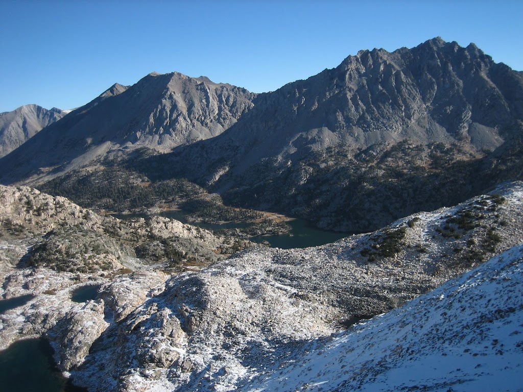
Prob. shows it as nothing. And, of course, the PCTers go thru one heck of a lot more. But consolidated snow vs.
brand spanking new snow is a different story.
For footwear, unless snow shoeing, just hiking shoes, goretex in spring and fall, non in summer.
Low gaitors for conditions as in pict.
Nope. They are not open to the general public. Maybe you could get some shelter on the "porch" but itQuote
TenderPaw
If someone was in an emergency could they not use the ranger station?
might not do anything if the wind is in the wrong direction. Many of those stations are Snow Survery
shelters and locked up year round. Do not mistaken them for something like Muir or Whitney Hut.
In Yose this is applicable to all the ones I mentioned above. Unless you break in, and that is prob.
unlikely you will be able to do... you are not getting in.
Here's the Wilma Shelter.
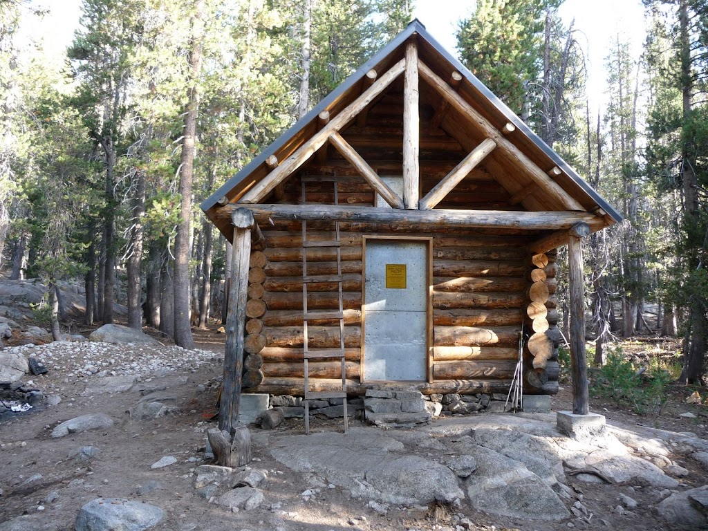
This is N. of the old shelter which burned down and of which only a fireplace now exists.
I go year round and am v. weary of snow come Oct. It doesn't stop us from going... it's just something to
be aware of and be prepared for.
Mid Nov (Cath Peak):

Mid Oct (Mt. Clark on the left):

Hope you do it
Good luck
January 12, 2011 03:26PM | Registered: 14 years ago Posts: 7,421 |
Quote
TenderPaw
I keep thinking of bringing a small light weight am fm radio for that section to listen to for weather updates. What are your thoughts on that, good or bad? Are there reliable weather updates on radios?
I have run into a couple of people who say they take a weather radio so
presumably they work ok. That's all I know.
Good Luck
|
Re: SHR north to Tuolumne, north along Tahoe Yosemite Trail January 13, 2011 04:33PM | Registered: 15 years ago Posts: 9 |
Sorry, only registered users may post in this forum.

