We had so much fun in 2010. We spend a long weekend in a heated tent cabin in Curry Village in Feb, and did some snowshoeing around Badger Pass. We also did a long weekend in July in TM, dayhiking around.
Other trips to the area: May 2005 - stayed in Curry Village, and hiked Nevada and Yosemite Falls. June 2006 - stayed at Redwood Lodge and hiked Hetch Hetchy 3/4 of the way to Rancheria.
I'd like to aim for at least two trips to Yosemite/Hetch Hetchy in 2011. I'd like at least one of those trips to include a beginner's backpacking overnight trip. I'm a slow-ish hiker, and can pretty much only do about 12-15 miles with a daypack, so it would need to be shorter if I'm going to carry something heavier.
I'd like to avoid crowds, see something beautiful (as though that's difficult), and do something I've never done before, or extend a previous hike.
I have some ideas, but want to see what you guys (and chickens) recommend.
TIA

The Moon is Waxing Gibbous (61% of Full)
Re: Help me plan my camping/backpacking trips for 2011
All posts are those of the individual authors and the owner
of this site does not endorse them. Content should be considered opinion
and not fact until verified independently.
January 11, 2011 07:02PM | Registered: 13 years ago Posts: 426 |
|
Re: Help me plan my camping/backpacking trips for 2011 January 12, 2011 06:11AM | Registered: 13 years ago Posts: 1,697 |
A good first time backpack trip is out to Glen Aulin. From your list, you still need to get to the top of North Dome and hike the Panorama trail. (of course there are many others) For the Pano trail, I drove up to Glacier Point, left my vehicle overnight, then took the bus back in the morning to retrieve it. It's not free, but this was the least expensive way, rather than our whole party paying to ride the bus.
The hike to Gaylor Lakes is a wonderful short hike up to some alpine lakes near the eastern entrance. You can go as far as you want extending it to your limits.
The hike to Gaylor Lakes is a wonderful short hike up to some alpine lakes near the eastern entrance. You can go as far as you want extending it to your limits.
January 12, 2011 09:31AM | Registered: 13 years ago Posts: 426 |
I should update my list. I was a bit tired when I posted this last night, and couldn't remember all the places we've been over the years.
We've been to:
North Dome, via Porcupine Flat
Devil's Postpile
Little Devil's Postpile
Gaylor Lakes
Dewey Point (on snowshoes)
Glacier Point (by car)
Yosemite Falls (up and down)
Nevada Fall (up via Mist Trail, down via JMT)
Mirror Lake (around to where the trail is closed)
Hetch Hetchy (3/4 around toward Rancheria Fall)
Merced Grove
Mariposa Grove
Valley Loop
TM Loop
I think that's everything.
Edited 1 time(s). Last edit at 01/12/2011 09:32AM by itchbay.
January 12, 2011 09:39AM | Registered: 13 years ago Posts: 426 |
Nice recommendations there. I have my book of hikes that served me well for getting to Little Devil's Postpile, and in it I had already flagged a couple of the trails you guys have recommended. 
I'm mostly just cabin-fever dreaming right now. But now's the time to put things on the calendar to ensure they actually happen.
Also, I don't mind people. I just don't like lines on the trail. Also, for day hikes, I enjoyed the Little Devil's Postpile "trail" along the western sides of the river much better than the backpackers trail on the eastern side. I know the backpackers trail needs to be wide and flat and well marked, but it almost felt like a freeway through there.
|
Re: Help me plan my camping/backpacking trips for 2011 January 12, 2011 04:46PM | Registered: 13 years ago Posts: 1,697 |
January 12, 2011 04:57PM | Registered: 14 years ago Posts: 7,421 |
CorrectoQuote
hotrod4x5
So the backpacker's campground at Glen Aulin is not actually Glen Aulin?
If you haven't seen this thread, you may like:
http://yosemitenews.info/forum/read.php?3,26056,26056#msg-26056
Go here and snag the Falls Ridge map and it should be clear that the HSC is not in Glen Aulin proper:
http://www.nps.gov/yose/planyourvisit/trails.htm

|
Re: Help me plan my camping/backpacking trips for 2011 January 12, 2011 06:28AM | Registered: 13 years ago Posts: 1,425 |
If you go to our website there is a whole list of about twenty hikes, both dayhikes and backpacking trips, just in Yosemite. And a few more if you want to enter the park from the east side via Twin Lake.
I'd second the notion of North Dome, Panorama Trail, and Gaylor Lakes...but there are a LOT more, too!
I'd second the notion of North Dome, Panorama Trail, and Gaylor Lakes...but there are a LOT more, too!
|
Re: Help me plan my camping/backpacking trips for 2011 January 12, 2011 06:35AM | Registered: 13 years ago Posts: 1,425 |
I"d also add another thought--you are not going to get solitude on an easy, scenic hike that's only 5 or six miles from the trailhead. That's just not the way Yosemite works---there are too many people. You can certainly get solitude there, but it takes a little more work, and a few more miles/days on the trail to accomplish that. Or a few miles off trail!
January 12, 2011 08:58AM | Registered: 15 years ago Posts: 1,372 |
Quote
balzaccom
I"d also add another thought--you are not going to get solitude on an easy, scenic hike that's only 5 or six miles from the trailhead. That's just not the way Yosemite works---there are too many people. You can certainly get solitude there, but it takes a little more work, and a few more miles/days on the trail to accomplish that. Or a few miles off trail!
I guess it all depends on the day. I solo camped two nights around the junction of Clouds Rest Trail and John Muir Trail. The first night was extremely packed with nearly all the impacted sites taken. There might have been 5 groups my first night including one rather loud group of Boy Scouts. The next night I had the area pretty much all to myself, and I moved to what I thought was a better spot.
January 12, 2011 07:19AM | Registered: 14 years ago Posts: 7,421 |
Quote
balzaccom
If you go to our website there is a whole list of about twenty hikes, both dayhikes and backpacking trips, just in Yosemite. And a few more if you want to enter the park from the east side via Twin Lake.
I'd second the notion of North Dome, Panorama Trail, and Gaylor Lakes...but there are a LOT more, too!
When you posty... check mark the "Add my signature to this message" so ur webbysite shows up.
Itchy will tank u
January 12, 2011 07:23AM | Registered: 14 years ago Posts: 7,421 |
Gaylor is dayhike only. No backpacking.
Purty sure gave you bunch o easy ones b4.
Go to Glen Aulin to ease u into tings. There's bear lockers there so u don't need a bear can.
It's not my cup o tea... but prolly good for 1st timer.
From there just dayhike down to Waterwheelies and back.
For HH, for first timers... Ranch falls ... but u gonna have to see when bridge is back up.
Have fun
|
Re: Help me plan my camping/backpacking trips for 2011 January 12, 2011 09:30AM | Registered: 13 years ago Posts: 1,697 |
January 12, 2011 10:14AM | Moderator Registered: 15 years ago Posts: 1,876 |
The lockers are at the High Sierra Camp, not in Glen Aulin.
(Don't know when they were placed there since I never camp at the HSCs. Several decades ago there used to be a cable in the GAHSC backpackers campground for counter-balance hanging of food; presumably the lockers were placed there when the cable was removed.)
Here is a useful link for bear locker locations throughout the Sierra:
http://climber.org/data/BearBoxes.html
Edit: Searching around the pages in the above link, came across this one:
http://climber.org/data/BearBoxes/YE06.html
which indicates that the bear cable was removed about 10 years ago.
(P.S. Love the anecdote about the bears bouncing on the cable in an attempt to slide the food towards them.)
Edited 3 time(s). Last edit at 01/12/2011 10:31AM by szalkowski.
January 12, 2011 10:51AM | Registered: 14 years ago Posts: 7,421 |
This is true.... but if you get a "Glen Aulin" permit... you are caming at the "campground" which is right smack-a-doodleQuote
szalkowski
The lockers are at the High Sierra Camp, not in Glen Aulin.
next to the HSC. So that's why I said what I said.
Glen Aulin Permit = Camping right next to HSC
Glen Aulin Passthru = Can camp at Glen Aulin "proper" or any pts. beyond the HSC
Have fun
January 12, 2011 04:20PM | Moderator Registered: 15 years ago Posts: 1,876 |
Quote
chick-on
This is true.... but if you get a "Glen Aulin" permit... you are caming at the "campground" which is right smack-a-doodleQuote
szalkowski
The lockers are at the High Sierra Camp, not in Glen Aulin.
next to the HSC. So that's why I said what I said.
Glen Aulin Permit = Camping right next to HSC
Glen Aulin Passthru = Can camp at Glen Aulin "proper" or any pts. beyond the HSC
Have fun
It's rumored that Chick-on hides out, nappies, and sleepies in the bear lockers because he is being constantly teased by the marmot pups for being such a "terrible lizard" ( http://www.omg-facts.com/view/Facts/23367 ).
The reason that I made the distinction is because the GA hike is one that I oftentimes use to introduce newcomers to backpacking. Over the years, I've met so many people along that trail that 'camped at Glen Aulin,' meaning the HSC, and (1) never realized that the HSC is not in GA, (2) never climbed over the ridge into GA, (3) never even knew that it was over there, or (4) don't know how to read, or carry, a map.
Edited 2 time(s). Last edit at 01/12/2011 06:46PM by szalkowski.
January 12, 2011 04:30PM | Registered: 14 years ago Posts: 7,421 |
Quote
szalkowski
Quote
chick-on
This is true.... but if you get a "Glen Aulin" permit... you are caming at the "campground" which is right smack-a-doodleQuote
szalkowski
The lockers are at the High Sierra Camp, not in Glen Aulin.
next to the HSC. So that's why I said what I said.
Glen Aulin Permit = Camping right next to HSC
Glen Aulin Passthru = Can camp at Glen Aulin "proper" or any pts. beyond the HSC
Have fun
It's rumored that Chick-on hides out, nappies, and sleepies in the bear lockers because he is being constantly teased by the marmot pups for being such a "terrible lizard" ( http://www.omg-facts.com/view/Facts/23367 ).
The reason that I made the distinction is because the GA hike is one that I oftentimes use to introduce newcomers to backpacking. Over the years, I've met so many people along that trail that 'camped at Glen Aulin,' meaning the HSC, and (1) never realized that the HSC is not in GA, (2) never climbed over the ridge into GA, (3) never even knew that it was over there, or (4) know how to read, or carry, a map.
You are correct, sir.
Lizardly yours,
January 12, 2011 05:03PM | Registered: 13 years ago Posts: 426 |
Ha. I've never been to GA, and until you mentioned it, I guess I'd assumed it was part of the HSC. I'll certainly put it on the short list. I'm hoping to spend a week in TM this summer, which will give us some time to do some backpacking as well as day hikes.
Another hike I'm considering is some kind of loop going from TM to the valley and back. I suppose it would be smarter to do the opposite, and have the tired part of the trip going downhill.
Another hike I'm considering is some kind of loop going from TM to the valley and back. I suppose it would be smarter to do the opposite, and have the tired part of the trip going downhill.
January 12, 2011 07:48PM | Moderator Registered: 15 years ago Posts: 1,876 |
Quote
itchbay
Ha. I've never been to GA, and until you mentioned it, I guess I'd assumed it was part of the HSC. I'll certainly put it on the short list.
The GAHSC was originally in GA, but eeek's grandfather stayed there one year and brought his pets (1 giga-
 ) along with him, prompting a move away from that location:
http://www.yosemitepark.com/Accommodations_HighSierraCamps_History.aspx
Edited 2 time(s). Last edit at 01/12/2011 08:18PM by szalkowski.
January 13, 2011 05:49AM | Moderator Registered: 15 years ago Posts: 1,942 |
Quote
szalkowski
Quote
itchbay
Ha. I've never been to GA, and until you mentioned it, I guess I'd assumed it was part of the HSC. I'll certainly put it on the short list.
The GAHSC was originally in GA, but eeek's grandfather stayed there one year and brought his pets (1 giga-
http://www.yosemitepark.com/Accommodations_HighSierraCamps_History.aspx
Wasn't Vogelsang moved from Booth Lake for a thousand similar reasons?
edit: I can't actually substantiate that claim but while looking for a reference, I found a very interesting collection of photos from the yosemite history site:
Almost every photo is revealing in some way about Yosemite. For example, I never could quite figure out where the La Nevada Casa was until I looked at the photo on this site and I was not aware of a mine on Mt. Dana.
http://www.yosemite.ca.us/library/one_hundred_years_in_yosemite/1931_plates.html
The cure for a fallacious argument is a better argument, not the suppression of ideas.
-- Carl Sagan
Edited 1 time(s). Last edit at 01/13/2011 06:36AM by Frank Furter.
January 13, 2011 07:58AM | Moderator Registered: 15 years ago Posts: 1,876 |
Quote
Frank Furter
Quote
szalkowski
Quote
itchbay
Ha. I've never been to GA, and until you mentioned it, I guess I'd assumed it was part of the HSC. I'll certainly put it on the short list.
The GAHSC was originally in GA, but eeek's grandfather stayed there one year and brought his pets (1 giga-
http://www.yosemitepark.com/Accommodations_HighSierraCamps_History.aspx
Wasn't Vogelsang moved from Booth Lake for a thousand similar reasons?
1000 giga-
= 1 tera- Yup, that's about right.
(I seem to recall that I did see a reference somewhere stating that the skeeter density was the reason that it was also moved. Many years ago, I made the major mistake of staying at Boothe and can attest that they are still there in biblical plague proportions.)
Edited 3 time(s). Last edit at 01/13/2011 08:28AM by szalkowski.
January 13, 2011 08:28AM | Registered: 14 years ago Posts: 7,421 |
Quote
Hot Dawg
<snip>
I was not aware of a mine on Mt. Dana.
Franky,
That's Gaylor Peak in the background (S of the structure). That pict. is actually of the Great Sierra Mine.
Here's what the building looks like today:

(so... it's not on Dana)
Here's a thread on High Sierra Camps:
http://yosemitenews.info/forum/read.php?1,14051,14051#msg-14051
|
Re: Help me plan my camping/backpacking trips for 2011 January 12, 2011 07:54PM | Registered: 15 years ago Posts: 187 |
Quote
itchbay
Ha. I've never been to GA, and until you mentioned it, I guess I'd assumed it was part of the HSC. I'll certainly put it on the short list. I'm hoping to spend a week in TM this summer, which will give us some time to do some backpacking as well as day hikes.
Another hike I'm considering is some kind of loop going from TM to the valley and back. I suppose it would be smarter to do the opposite, and have the tired part of the trip going downhill.
One of my standards is park at Sunrise TH to take trail up to Sunrise lakes (dive in), go up the knoll sleep w an over look of Tenaya Canyon, next day hike to Cloud's rest, then down to Lil Yose Valley (crowds), sleep, then JMT via Nevada Falls to Happy Isles, shuttle to Visitor ctr then take YARTS back to vehicle...it's pretty fun, but can be crowded...one time I took the Mist Trail down w/ a 60lb pack scary has heck.
January 12, 2011 07:36AM | Registered: 14 years ago Posts: 7,421 |
January 12, 2011 07:38AM | Registered: 15 years ago Posts: 2,321 |
January 12, 2011 06:02PM | Registered: 13 years ago Posts: 1,351 |
I love Ten Lakes basin. Especially camping at one of the lakes off the 'trail' (none of them are that far apart).
Young Lakes may not be bad for a 'first time backpack' - there will be plenty of people, but it's quite pretty and not too far. Plus, w/ two trails in the exit trail can be different from the entry. I took a friend there for a first time trip long ago, he was dead tired (not in shape) when he got there, but loved it once he recovered. She's been to Nevada Falls, which is a larger vertical. In fact, the Vogelsang area is less of a vertical than Nevada, and it opens up lots of exploration possibilities.
Young Lakes may not be bad for a 'first time backpack' - there will be plenty of people, but it's quite pretty and not too far. Plus, w/ two trails in the exit trail can be different from the entry. I took a friend there for a first time trip long ago, he was dead tired (not in shape) when he got there, but loved it once he recovered. She's been to Nevada Falls, which is a larger vertical. In fact, the Vogelsang area is less of a vertical than Nevada, and it opens up lots of exploration possibilities.
January 13, 2011 01:56AM | Registered: 13 years ago Posts: 424 |
Ten Lakes is definitely gorgeous. I still remember the first time I crested over the trail and saw the view into the basin. Its absolutely spectacular. That trail is like a highway, there's no way you'll lose it. There always is a lot of people there, that is a downside. However, as the previous poster said, if you're willing to go further up to the lakes that you don't hit immediately, you should be able to get one to yourself. Also, I've stayed on the ridge above the lakes during a meteor storm, that was amazing to watch.
The place I recommend first timers go is to Lake Eleanor after the Forest Service unlocks the gate at Cherry Lake. Its an easy hike in and in my opinion its a good way to ease someone into backpacking from car camping.
The place I recommend first timers go is to Lake Eleanor after the Forest Service unlocks the gate at Cherry Lake. Its an easy hike in and in my opinion its a good way to ease someone into backpacking from car camping.
January 15, 2011 09:21AM | Registered: 15 years ago Posts: 1,876 |
Another good 1-nighter is take Cathedral Lake trail on the JMT and then go off-trail just past Echo Peaks down to the Echo Lake area or below that to camp. Don't forget the half mile side trip to Lower Cathedral Lake and hike all the way around it. The next day rejoin the Echo Canyon trail back up to Sunrise HSC and down past Sunrise Lakes. After Sunrise Lakes don't forget to check out the knob that overlooks Tenaya Canyon. Take final exit on Sunrise Lakes trail to Tenaya Lake. Works in reverse too.
Regarding Young Lakes: If you get an early enough start and don't like crowds or lake area mosquitos earlier in the summer there is another good campsite option. Take the Dog Lake trail on the way up and be sure to check out Dog Lake. Use the westward trail to return partway from Young Lakes the same day. On the Natl Geo trail map you can see where the no camping zone begins. Just before the no camping zone about a mile below where the trail splits there is a small promintory on the right with a large clearing which overlooks the Conness Creek watershed. Altitude is 9,700'. It's a few hundred feet off -trail and you will likely have the place to yourself. Carry plenty of water from the last creek you cross because this is a dry camp. Sleep in and walk out at your liesure the next day.
Regarding Young Lakes: If you get an early enough start and don't like crowds or lake area mosquitos earlier in the summer there is another good campsite option. Take the Dog Lake trail on the way up and be sure to check out Dog Lake. Use the westward trail to return partway from Young Lakes the same day. On the Natl Geo trail map you can see where the no camping zone begins. Just before the no camping zone about a mile below where the trail splits there is a small promintory on the right with a large clearing which overlooks the Conness Creek watershed. Altitude is 9,700'. It's a few hundred feet off -trail and you will likely have the place to yourself. Carry plenty of water from the last creek you cross because this is a dry camp. Sleep in and walk out at your liesure the next day.
|
Re: Help me plan my camping/backpacking trips for 2011 January 17, 2011 03:20PM | Registered: 14 years ago Posts: 755 |
If I understand it correctly, this will be your first mountain backpacking trip. In that case, let me make a suggestion for making this experience enjoyable.
In my mind, there are two very different ways to do this. One is to choose a popular high altitude route, on a heavily traveled trail to a heavily visited destination. Glen Aulin is a good example of this sort of thing. My first backpacking trip in Yosemite went in a bit farther on the first day, towards Waterwheel Falls. It was Fourth of July weekend in 1983, and we had been assured that summer in Yosemite meant that all we would need was warm (water-shedding) clothes, a sleeping bag, and a tarp. The first night it snowed. We nearly froze. But it was a memorable trip, and the falls were terrific. We were experienced backpackers from the East, so we had no trouble with the heavy packs or the cold-waeather camping.
The other way to begin mountain backpacking is with something simpler. If you are not very experienced, and aren't completely sure about wilderness cooking and sanitary arrangements and heavy packs and bear canisters and tents and squalor and rain squalls and all that, let me suggest that you make your first trip one where it is possible to disengage gracefully. To that end, I would suggest a short hike in to a base camp from which you can do interesting day excursions.
All Yosemite trailheads have a minimum distance that you must hike in before you can camp. See this map: trailhead map link The more popular the route, the farther that you have to go. For example, from Tuolumne you would have to go to Glen Aulin or beyond, or well up one of the side trails. After driving to that altitude from flatland, without a chance to acclimate, that becomes a real grunt.
From Happy Isles or Glacier Point, the story is the same. But there are less popular trailheads where the required trek is much less. And some are at lower altitude. Here is one that I have used:
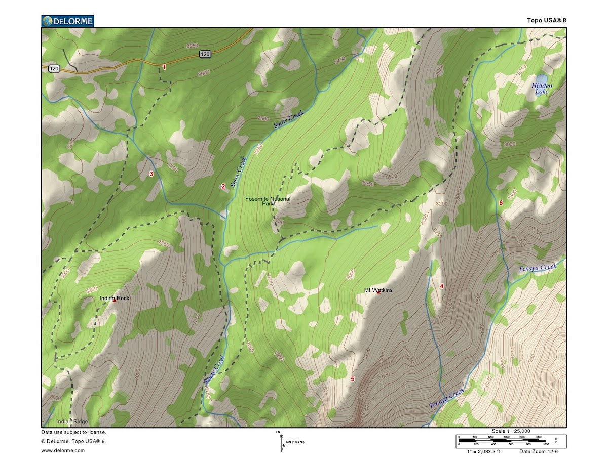
On the map, #1 is the Porcupine Flat Trailhead. That was our entry point. You only have to go past Porcupine Creek before you are allowed to camp. And it's downhill.
Here's the story. It's Fourth of July again, but 35 years or so after our Glen Aulin trip. Our college-age daughters and their husbands-to-be want some backpacking, but they want to bring a pair of female college friends who are interesting in trying out this sort of thing. They don't seem very outdoorsy, so I set up this trip. On the map, #2 shows the camp site we specified for the wilderness permit. But the mosquito situation in July can be bad near the creeks, so the scouts in our group found a possibly better camp site near #3. It's in an area of mixed forest and bare granite. It has a thigh-high shelf of rock for cooking, which the ladies liked. Plenty of logs for sitting, and running water not far away. Perfect.
As an experiment in backpacking it was also perfect. In the morning, the two guests packed up and left. Their packs had been too heavy, the ground had been too hard, there had been bugs and mosquitoes, and there were important TV programs that they were missing. Actually, I'm sure that the real problem was the little pit latrine that we had dug. The idea of squatting and pooping in the woods was just too dreadful. Undignified. They left in search of a motel with indoor plumbing.
After which the kids and my wife and I had several perfect days of side trips. It's an easy hike to Mt. Watkins. If you go there, be sure to visit the lookouts at #4 and #5, with their spectacular views of Clouds Rest, Half Dome, Pywiack Cascade, and Tenaya Canyon. Indian Rock and North Dome are nearby, or you can hike over for the view at Yosemite Point. On the way back from North Dome, you can visit Basket Dome and then walk home along the ridge to its north (see link:basket dome). Airplane gully is also nearby (#6 link: airplane), and the trail from Watkins saddle to Olmstead Point is an extremely scenic alternative.
Best of luck on your trip. If the short one works well, you can be sure of enjoying a more strenuous one later....
In my mind, there are two very different ways to do this. One is to choose a popular high altitude route, on a heavily traveled trail to a heavily visited destination. Glen Aulin is a good example of this sort of thing. My first backpacking trip in Yosemite went in a bit farther on the first day, towards Waterwheel Falls. It was Fourth of July weekend in 1983, and we had been assured that summer in Yosemite meant that all we would need was warm (water-shedding) clothes, a sleeping bag, and a tarp. The first night it snowed. We nearly froze. But it was a memorable trip, and the falls were terrific. We were experienced backpackers from the East, so we had no trouble with the heavy packs or the cold-waeather camping.
The other way to begin mountain backpacking is with something simpler. If you are not very experienced, and aren't completely sure about wilderness cooking and sanitary arrangements and heavy packs and bear canisters and tents and squalor and rain squalls and all that, let me suggest that you make your first trip one where it is possible to disengage gracefully. To that end, I would suggest a short hike in to a base camp from which you can do interesting day excursions.
All Yosemite trailheads have a minimum distance that you must hike in before you can camp. See this map: trailhead map link The more popular the route, the farther that you have to go. For example, from Tuolumne you would have to go to Glen Aulin or beyond, or well up one of the side trails. After driving to that altitude from flatland, without a chance to acclimate, that becomes a real grunt.
From Happy Isles or Glacier Point, the story is the same. But there are less popular trailheads where the required trek is much less. And some are at lower altitude. Here is one that I have used:
On the map, #1 is the Porcupine Flat Trailhead. That was our entry point. You only have to go past Porcupine Creek before you are allowed to camp. And it's downhill.
Here's the story. It's Fourth of July again, but 35 years or so after our Glen Aulin trip. Our college-age daughters and their husbands-to-be want some backpacking, but they want to bring a pair of female college friends who are interesting in trying out this sort of thing. They don't seem very outdoorsy, so I set up this trip. On the map, #2 shows the camp site we specified for the wilderness permit. But the mosquito situation in July can be bad near the creeks, so the scouts in our group found a possibly better camp site near #3. It's in an area of mixed forest and bare granite. It has a thigh-high shelf of rock for cooking, which the ladies liked. Plenty of logs for sitting, and running water not far away. Perfect.
As an experiment in backpacking it was also perfect. In the morning, the two guests packed up and left. Their packs had been too heavy, the ground had been too hard, there had been bugs and mosquitoes, and there were important TV programs that they were missing. Actually, I'm sure that the real problem was the little pit latrine that we had dug. The idea of squatting and pooping in the woods was just too dreadful. Undignified. They left in search of a motel with indoor plumbing.
After which the kids and my wife and I had several perfect days of side trips. It's an easy hike to Mt. Watkins. If you go there, be sure to visit the lookouts at #4 and #5, with their spectacular views of Clouds Rest, Half Dome, Pywiack Cascade, and Tenaya Canyon. Indian Rock and North Dome are nearby, or you can hike over for the view at Yosemite Point. On the way back from North Dome, you can visit Basket Dome and then walk home along the ridge to its north (see link:basket dome). Airplane gully is also nearby (#6 link: airplane), and the trail from Watkins saddle to Olmstead Point is an extremely scenic alternative.
Best of luck on your trip. If the short one works well, you can be sure of enjoying a more strenuous one later....
|
Re: Help me plan my camping/backpacking trips for 2011 January 17, 2011 03:32PM | Registered: 14 years ago Posts: 923 |
Really short and easy to get back out of if things go wildly wrong: Polly Dome.
Really scenic, tho I can't vouch for crowds (there is a ferry that takes people back and forth across the lake). Saddlebag Lake, Conness Lakes, all the other lakes in the basin - go as far as you like. It's just outside Yosemite so permitting if any will be via Inyo NF. Not terribly strenuous, great big payoffs.
A bit more ambitious with some okay scenery: Ostrander Lake, 12 mile round trip. I take newbies every year, permitting is usually easy to come by and there are large brook trout in the lake.
Sorry, only registered users may post in this forum.

