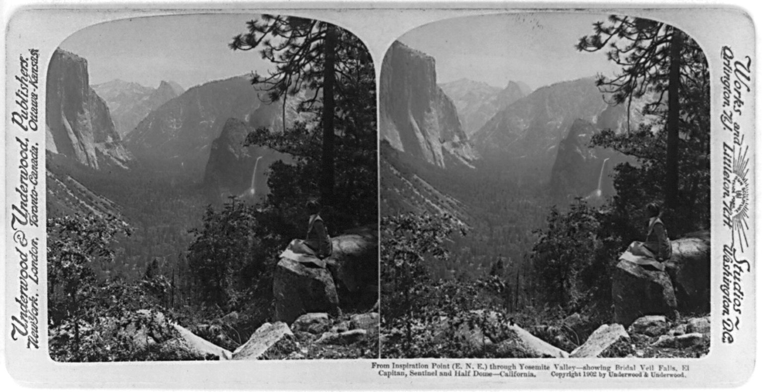
From Inspiration Point (E.N.E.) through Yosemite Valley - showing Bridal Veil Falls, El Capitan, Sentinel and Half Dome - California c1902.
http://www.loc.gov/pictures/collection/stereo/item/2002705613/

The Moon is Waxing Gibbous (58% of Full)
January 30, 2011 04:30PM | Admin Registered: 15 years ago Posts: 17,050 |
|
Re: Stereo View from Inspiration Point January 30, 2011 07:30PM | Registered: 13 years ago Posts: 103 |
January 31, 2011 10:41AM | Moderator Registered: 15 years ago Posts: 1,918 |
|
Re: Stereo View from Inspiration Point January 31, 2011 11:20AM | Registered: 13 years ago Posts: 13 |
January 31, 2011 01:12PM | Registered: 15 years ago Posts: 305 |
January 31, 2011 05:05PM | Moderator Registered: 15 years ago Posts: 1,918 |
February 02, 2011 07:32PM | Admin Registered: 15 years ago Posts: 17,050 |
February 02, 2011 09:57PM | Registered: 14 years ago Posts: 7,421 |
|
Re: Stereo View from Inspiration Point February 03, 2011 05:38PM | Registered: 13 years ago Posts: 617 |
Quote
chick-on
Yes sirQuote
eeek
Is this from the Four Mile Trail?
|
Re: Stereo View from Inspiration Point February 04, 2011 06:50PM | Registered: 13 years ago Posts: 864 |
February 06, 2011 09:34AM | Registered: 14 years ago Posts: 7,421 |
Quote
basilbop
Both of the old sections and the Sentinel Dome trail above (and the Sierra Point trail) are on the old govnernment Yosemite Valley topo--the one with the brown-orange cover with the Matthes geologic information on the back.

|
Re: Stereo View from Inspiration Point February 06, 2011 01:03PM | Registered: 13 years ago Posts: 864 |
February 06, 2011 02:28PM | Registered: 14 years ago Posts: 7,421 |
|
Re: Stereo View from Inspiration Point February 06, 2011 05:38PM | Registered: 14 years ago Posts: 755 |
Quote
basilbop
This is the closest I could find online: https://store.usgs.gov/yimages/PDF/CA_Yosemite_Valley_1970_45934_&_45933.pdf (warning: this is a 50mb download). This map seems to have only the old alignment of the Four Mile Trail just below (west of) Glacier Pt., but it also has the Union Point comfort station, both segments below Union Point, the Sentinel Dome shortcut from the Four Mile Trail, and the Sierra Point trail. (Oddly, it also has the Yosemite Wilderness boundaries, which didn't exist until 1984.)
Based on old maps, the Moran Point trail seems like it would have followed the new Four Mile Trail north of Union Point, then continued past the first swithcback. I do remember a faint use trail continuing in this direction, but many switchbacks on popular trails have similar informal trails...
|
Re: Stereo View from Inspiration Point February 06, 2011 06:44PM | Registered: 13 years ago Posts: 1,697 |
February 06, 2011 07:18PM | Registered: 14 years ago Posts: 7,421 |
February 06, 2011 07:41PM | Moderator Registered: 15 years ago Posts: 1,876 |
February 06, 2011 08:38PM | Registered: 14 years ago Posts: 7,421 |
February 08, 2011 08:14AM | Registered: 14 years ago Posts: 7,421 |
|
Re: Stereo View from Inspiration Point February 08, 2011 01:41PM | Registered: 13 years ago Posts: 617 |
Quote
chick-on
Other interesting items include:
- Old trail by Ft. Monroe
 ).
).February 08, 2011 02:13PM | Admin Registered: 15 years ago Posts: 17,050 |
Quote
DavidK42
I've really gotta get some software that makes it easy to overlay these maps on top of one another for this kind of comparison. (Anybody got any suggestions? Especially when you have the maps as PDF's?)
|
Re: Stereo View from Inspiration Point February 08, 2011 02:20PM | Registered: 13 years ago Posts: 617 |
|
Re: Stereo View from Inspiration Point February 08, 2011 10:21PM | Registered: 13 years ago Posts: 864 |
February 22, 2011 03:35AM | Registered: 15 years ago Posts: 4,173 |
Quote
basilbop
Based on old maps, the Moran Point trail seems like it would have followed the new Four Mile Trail north of Union Point, then continued past the first switchback. I do remember a faint use trail continuing in this direction, but many switchbacks on popular trails have similar informal trails...
February 22, 2011 08:31AM | Registered: 14 years ago Posts: 7,421 |
Quote
plawrence
Quote
basilbop
Based on old maps, the Moran Point trail seems like it would have followed the new Four Mile Trail north of Union Point, then continued past the first switchback. I do remember a faint use trail continuing in this direction, but many switchbacks on popular trails have similar informal trails...
Nope. You can't get to Moran Point from that section of the Four Mile Trail unless you want to repel down a cliff.
The topo maps leads to this confusion, but Moran Point is only about 1000 feet above the Valley floor, and not really accessible from the Four Mile Trail. To reach Moran Point from the Valley one would need to hike up the gully/wash from behind the Sierras Club LeConte Memorial Lodge. Or one could take the old Ledge Trail from Glacier Point and break off from that trail to reach Moran Point.
The official GPS coordinates for Moran Point are: 37.7365925, -119.5815530 (http://goo.gl/1ecr8).
One can view the spot on Google Maps (where the green arrow is located): http://goo.gl/A1F8g


February 22, 2011 10:58AM | Registered: 15 years ago Posts: 4,173 |
Quote
chick-on
Quote
plawrence
Nope. You can't get to Moran Point from that section of the Four Mile Trail unless you want to repel down a cliff.
The topo maps leads to this confusion, but Moran Point is only about 1000 feet above the Valley floor, and not really accessible from the Four Mile Trail. To reach Moran Point from the Valley one would need to hike up the gully/wash from behind the Sierras Club LeConte Memorial Lodge. Or one could take the old Ledge Trail from Glacier Point and break off from that trail to reach Moran Point.
The official GPS coordinates for Moran Point are: 37.7365925, -119.5815530 (http://goo.gl/1ecr8).
One can view the spot on Google Maps (where the green arrow is located): http://goo.gl/A1F8g
I dunno... I'm not buying it. I've never seen a map or anything showing it E of the gully S of LeConte Memorial.
Been on the ledge trail... and if they wanted to name a Pt there... IMO they would have named the JUST below
the turn on the Ledge Trail.
Here's a map that shows it w/ elevation:
and
and (but not really much help):
http://www.yosemite.ca.us/library/yosemite_valley_place_names/
Also seen a map with it right ON the Four Mile/Glacier Pt. trail.
Even the map they give out NOW shows Moran W of the Gully and v. close to 4 Mile Trail.
February 22, 2011 11:15AM | Registered: 15 years ago Posts: 4,173 |
Quote
chick-on
Quote
plawrence
Quote
basilbop
Based on old maps, the Moran Point trail seems like it would have followed the new Four Mile Trail north of Union Point, then continued past the first switchback. I do remember a faint use trail continuing in this direction, but many switchbacks on popular trails have similar informal trails...
Nope. You can't get to Moran Point from that section of the Four Mile Trail unless you want to repel down a cliff.
The topo maps leads to this confusion, but Moran Point is only about 1000 feet above the Valley floor, and not really accessible from the Four Mile Trail. To reach Moran Point from the Valley one would need to hike up the gully/wash from behind the Sierras Club LeConte Memorial Lodge. Or one could take the old Ledge Trail from Glacier Point and break off from that trail to reach Moran Point.
The official GPS coordinates for Moran Point are: 37.7365925, -119.5815530 (http://goo.gl/1ecr8).
One can view the spot on Google Maps (where the green arrow is located): http://goo.gl/A1F8g
I dunno... I'm not buying it. I've never seen a map or anything showing it E of the gully S of LeConte Memorial.
Even the map they give out NOW shows Moran W of the Gully and v. close to 4 Mile Trail.
February 22, 2011 11:58AM | Registered: 15 years ago Posts: 4,173 |


February 22, 2011 01:30PM | Registered: 15 years ago Posts: 4,173 |
Quote
basilbop
Here's a map that shows it w/ elevation:


February 22, 2011 02:42PM | Registered: 14 years ago Posts: 7,421 |
February 22, 2011 03:35PM | Registered: 15 years ago Posts: 4,173 |
Quote
chick-on
Here's the view from Union Pt. which is about the same elevation and looks eerily similar to the Moran Pt. photos:
February 22, 2011 03:52PM | Registered: 14 years ago Posts: 7,421 |
February 22, 2011 04:04PM | Admin Registered: 15 years ago Posts: 17,050 |
Quote
chick-on
Here's a really good map that should put the question to rest:
http://gisserver.princeton.edu:81/navigatorMapViewer.htm?map=911
February 22, 2011 04:17PM | Registered: 15 years ago Posts: 4,173 |
Quote
eeek
Quote
chick-on
Here's a really good map that should put the question to rest:
http://gisserver.princeton.edu:81/navigatorMapViewer.htm?map=911
Access Denied.
February 22, 2011 04:21PM | Admin Registered: 15 years ago Posts: 17,050 |
Quote
plawrence
Quote
eeek
Quote
chick-on
Here's a really good map that should put the question to rest:
http://gisserver.princeton.edu:81/navigatorMapViewer.htm?map=911
Access Denied.
Interesting, I had no problem accessing the map. I suggest that you try again.
If you still have problems, I would suggest checking your browser's security settings.
February 22, 2011 04:29PM | Registered: 15 years ago Posts: 4,173 |
February 22, 2011 04:57PM | Registered: 14 years ago Posts: 7,421 |
This is effectively what basilbop said above I believe.Quote
plawrence
Looking at the Princeton map of Yosemite, it shows the old alignment of the Four Mail Trail after it descends past Union Point heading toward the Valley. On the Princeton map, the beginning (first-half) of the spur that leads to Moran Point appears to be now part of the modern Four Mile Trail alignment past Union Point.
|
Re: Stereo View from Inspiration Point April 04, 2011 03:47PM | Registered: 13 years ago Posts: 47 |
February 03, 2011 02:54AM | Registered: 15 years ago Posts: 670 |
February 03, 2011 04:30AM | Admin Registered: 15 years ago Posts: 17,050 |
February 03, 2011 07:10AM | Registered: 14 years ago Posts: 7,421 |
February 03, 2011 11:59AM | Registered: 15 years ago Posts: 2,321 |
|
Re: Stereo View from Inspiration Point March 26, 2011 11:42PM | Registered: 13 years ago Posts: 28 |


