http://yosemitenews.info/forum/read.php?3,31794,32344#msg-32344
http://yosemitenews.info/forum/read.php?3,31794,32358#msg-32358
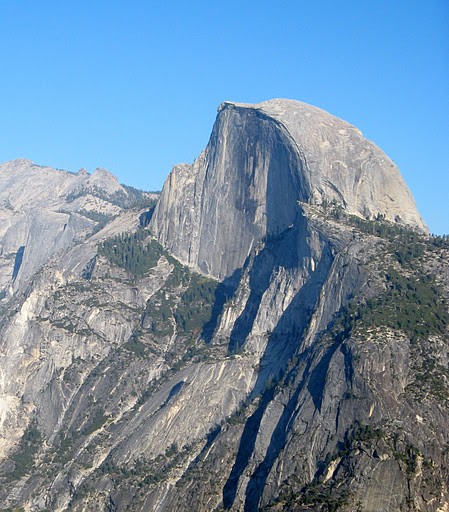
Today:
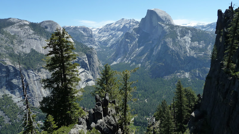
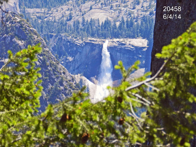
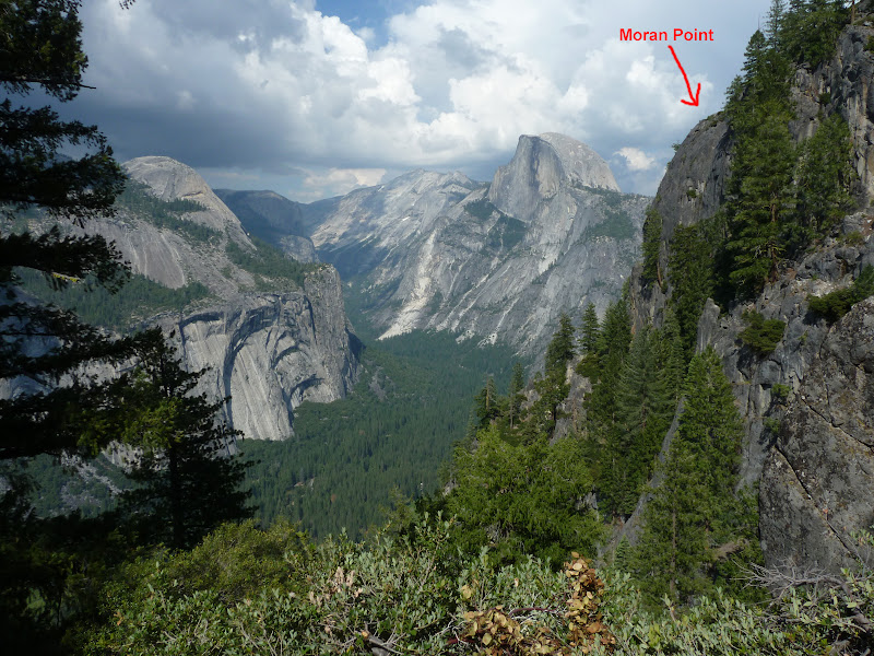
If you go out all the way you can also see Nevada Falls:

June 12, 2011 08:24PM | Registered: 14 years ago Posts: 7,421 |
June 12, 2011 08:28PM | Registered: 14 years ago Posts: 7,421 |
June 12, 2011 11:23PM | Registered: 15 years ago Posts: 4,173 |
Quote
chick-on
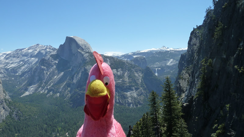
Today:
If you go out all the way you can also see Nevada Falls:

June 13, 2011 03:52AM | Registered: 15 years ago Posts: 670 |
June 13, 2011 08:10AM | Registered: 14 years ago Posts: 7,421 |

June 13, 2011 08:09AM | Registered: 14 years ago Posts: 7,421 |
June 13, 2011 11:33AM | Registered: 15 years ago Posts: 4,173 |
June 13, 2011 02:02PM | Registered: 14 years ago Posts: 7,421 |
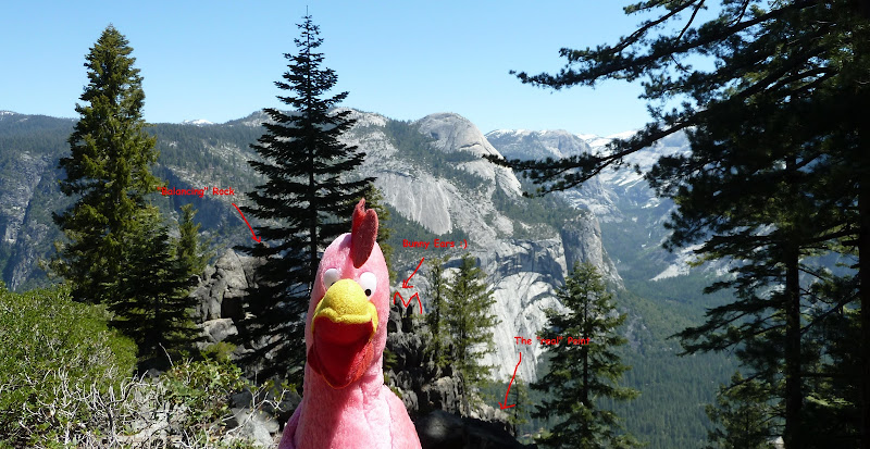
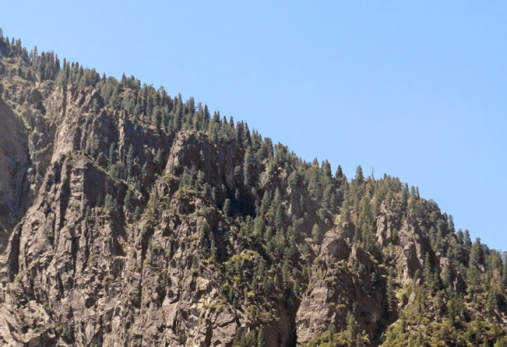
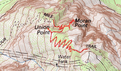
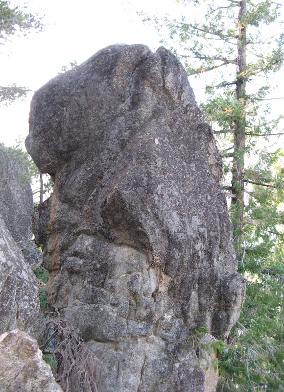
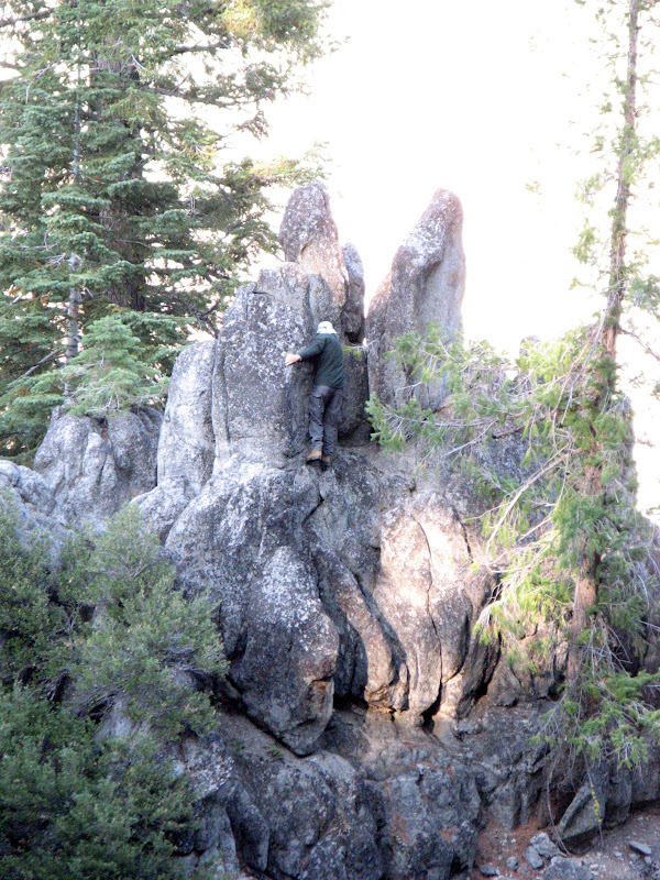
There wasn't any trail to speak of. A game trail perhaps. I saw deer tracks to the point area and bear scat below the "balancing" rock.Quote
plawrence
Was there any sort of old trail you followed from the 4-mile trail to Moran Point? Or was it mostly, or all, cross-country?
Well, I was just nitpicking cause it seemed you were busting my balls on the shot.Quote
plawrence
What makes you believe that the true Moran Point is further out than what is depicted in the Watkins and Fiske's photos from Moran Point: topo maps, a USGS official marker at the true point, a guard-rail, or a sign indicating the actual Moran Point?
That was taken very close to where the end "point" is. Below almost everything you see in Fiske's photo.Quote
plawrence
And finally, about that nice shot of Upper and Lower Yosemite Falls, was that taken at the actual Moran Point, or somewhere between Moran Point and the 4-Mile trail?
|
Re: Moran Point June 13, 2011 11:19AM | Registered: 15 years ago Posts: 118 |
June 13, 2011 11:26AM | Registered: 15 years ago Posts: 670 |
June 13, 2011 01:54PM | Registered: 14 years ago Posts: 7,421 |
Correct. Very straightforward and very close to the turn.Quote
qumqats
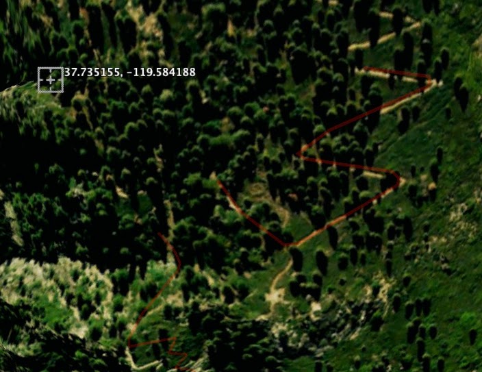
OK, so the on straightaway downtrail from Union Point don't start down the hairpins, keep going straight following the contour line to the Point . . ?
July 08, 2011 09:38AM | Registered: 15 years ago Posts: 4,173 |
Quote
chick-on
Quote
qumqats
OK, so the on straightaway downtrail from Union Point don't start down the hairpins, keep going straight following the contour line to the Point . . ?
Correct. Very straightforward and very close to the turn.
If you want to get all the way out (where you can only go DOWN) then you have a bit of shrubbery dancing to do.
July 10, 2011 09:32AM | Registered: 14 years ago Posts: 7,421 |
July 11, 2011 12:06AM | Registered: 15 years ago Posts: 4,173 |
Quote
chick-on
I went to the turn and just kept going straight. Yes, it's steep... but it's dirt so it wasn't bad imo.
When I came back I did the same thing and hit the switchback on the button.
Hiking sticks can help...

Quote
chick-on
The beauty of the Point IMO is that if you go ALL the way out you can see Nevada Falls.
But if you hesitate on the initial traverse I highly doubt you will want to do what is needed to
go all the way out there. Interestingly on my way out there (and beyond the "bunny ears" rock)
a bear decided to do it's business and left me a present...
There was another point MUCH higher up that looked interesting...
July 11, 2011 01:33AM | Registered: 15 years ago Posts: 4,173 |
July 11, 2011 08:25AM | Registered: 14 years ago Posts: 7,421 |


July 11, 2011 09:09AM | Registered: 15 years ago Posts: 4,173 |
July 11, 2011 11:37AM | Registered: 14 years ago Posts: 7,421 |
Buried under 50+ years o dirt?Quote
plawrence
So where is the remnants of that trail today?
June 09, 2014 10:53AM | Registered: 11 years ago Posts: 299 |
Quote
plawrence
... if you look just above the junction of the Four Mile Trail with the Union Point spur, you'll notice what appears to be another possible trail that runs up the ridge a short ways then veers left towards Moran Point before disappearing in the brush and trees. Could this possibly be the start of the old trail to Moran Point?
June 09, 2014 10:10PM | Registered: 11 years ago Posts: 299 |
May 26, 2014 02:39PM | Registered: 11 years ago Posts: 299 |
Quote
chick-on
I went to the turn and just kept going straight. Yes, it's steep... but it's dirt so it wasn't bad imo.
When I came back I did the same thing and hit the switchback on the button.
Hiking sticks can help...


 could those be the bunny ears?


May 27, 2014 06:20AM | Moderator Registered: 14 years ago Posts: 7,421 |
May 28, 2014 05:03PM | Registered: 11 years ago Posts: 299 |
Quote
chick-on
Here's faux toe took then of Moran from up the hill from Ahwahnee...


June 09, 2014 10:49PM | Registered: 11 years ago Posts: 299 |


July 08, 2011 09:46AM | Registered: 15 years ago Posts: 4,173 |
Quote
rightstar76
Awesome views! Another great place to visit in Yosemite. Thanks for sharing. I wish I were there right now!
August 25, 2012 02:03PM | Registered: 15 years ago Posts: 4,173 |

September 06, 2012 07:44AM | Moderator Registered: 14 years ago Posts: 7,421 |

November 27, 2012 10:33AM | Moderator Registered: 14 years ago Posts: 7,421 |
November 27, 2012 04:34PM | Registered: 15 years ago Posts: 4,173 |
November 27, 2012 09:28PM | Moderator Registered: 14 years ago Posts: 7,421 |
November 27, 2012 10:13PM | Registered: 15 years ago Posts: 4,173 |
November 27, 2012 10:19PM | Registered: 15 years ago Posts: 4,173 |
November 28, 2012 07:59AM | Moderator Registered: 14 years ago Posts: 7,421 |


November 28, 2012 11:05AM | Registered: 15 years ago Posts: 4,173 |
Quote
chick-on
If you take the picture east to Half Dome where 4 Mile makes the turn and the gate is near Union...
you are looking at the north wall of Moran...
November 28, 2012 09:29PM | Moderator Registered: 14 years ago Posts: 7,421 |
November 28, 2012 11:50PM | Registered: 15 years ago Posts: 4,173 |
November 28, 2012 09:38PM | Moderator Registered: 14 years ago Posts: 7,421 |
June 23, 2013 09:57PM | Registered: 11 years ago Posts: 299 |


November 28, 2012 03:53PM | Registered: 11 years ago Posts: 299 |


November 28, 2012 06:50PM | Registered: 15 years ago Posts: 4,173 |
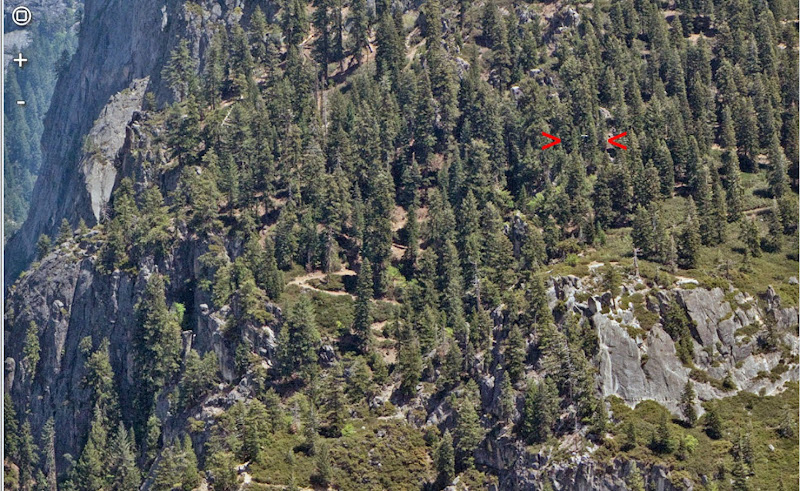
Quote
gophersnake
Hi folks, new here. I love these discussions of lost geographical features!
I was on the Upper Yosemite Falls Trail in early October taking pictures of the Four Mile Trail and vicinity. I'm going to attach a few I happened to get of the Union, Moran, and Glacier Points area. Maybe they'll be relevant to this discussion.
The first two were taken from Columbia Rock, the other two from the spur trail above Lower Yosemite Fall. They all looked kind of blue-hazy (like the third one or worse) so I Photoshopped all but the third one to remove most of the cyan and blue. That makes them look almost monochrome so I cranked up what little color was left. That's why the chartreuse vegetation.
I'm not a hundred percent sure what I'm looking at except for Glacier Point (in three of the four). I think I know which one is Union Point but I'd welcome a second opinion anyway.
can correct me if I'm off-base on that).
November 28, 2012 08:51PM | Registered: 11 years ago Posts: 299 |

November 29, 2012 12:08AM | Registered: 15 years ago Posts: 4,173 |
Quote
gophersnake
Ooh, I like your restored-color versions! What did you use, if you don't mind telling?
Quote
gophersnake
Here's what I thought was Union Point, maybe even with Agassiz Column peeking through the trees to the left of center. I left the haze in place this time. You seem to do a better job of enhancing than I do.
November 28, 2012 09:21PM | Registered: 11 years ago Posts: 299 |


November 28, 2012 09:35PM | Moderator Registered: 14 years ago Posts: 7,421 |
November 28, 2012 11:58PM | Registered: 15 years ago Posts: 4,173 |
Quote
chick-on
The trail looks more or less like this:
I also drew in in dots the old trail portion by the traverse. Don't count switchbacks though. I just v. crudely drew in a trail.
November 29, 2012 01:36AM | Registered: 11 years ago Posts: 299 |
I doubt it very much. The Four Mile Trail first switchbacks its way up to about 7000, then levels off and continues on to Glacier Point barely climbing. At Glacier Point it connects to the Pohono Trail which climbs gently toward Sentinel Dome. A shortcut from the Four Mile to the Pohono would have needed some serious switchbacks wherever it was located. It wouldn't have made much sense to duplicate the ones already in place above Union Point.Quote
plawrence
Could what looks like a trail with switchbacks above the traverse be the trail that connects the Four Mile Trail with Sentinel Dome?


November 29, 2012 02:32AM | Registered: 11 years ago Posts: 299 |


November 29, 2012 02:59AM | Registered: 11 years ago Posts: 299 |


November 29, 2012 06:49AM | Moderator Registered: 14 years ago Posts: 7,421 |


December 01, 2012 02:37AM | Registered: 11 years ago Posts: 299 |
Quote
chick-on
I have a feeling you haven't seen this other thread:
http://yosemitenews.info/forum/read.php?3,47695,47695#msg-47695
December 01, 2012 04:00AM | Registered: 12 years ago Posts: 343 |
December 01, 2012 05:04PM | Moderator Registered: 14 years ago Posts: 7,421 |
December 03, 2012 04:56PM | Registered: 12 years ago Posts: 578 |
|
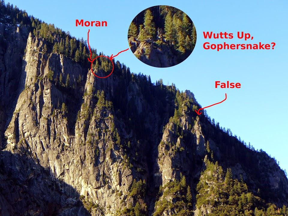
Re: Moran Point May 28, 2014 03:54PM | Registered: 12 years ago Posts: 129 |
May 28, 2014 04:33PM | Registered: 11 years ago Posts: 299 |
-- Yosemite Valley Place Names (1955)Quote
Richard J. Hartesveldt
MORAN POINT is located on the south valley wall just east from Union Point. It was named for the famed painter of western scenes, Thomas Moran."
November 29, 2012 03:18AM | Registered: 15 years ago Posts: 4,173 |
Quote
gophersnake
Quote
plawrence
Could what looks like a trail with switchbacks above the traverse be the trail that connects the Four Mile Trail with Sentinel Dome?
I doubt it very much. The Four Mile Trail first switchbacks its way up to about 7000, then levels off and continues on to Glacier Point barely climbing. At Glacier Point it connects to the Pohono Trail which climbs gently toward Sentinel Dome. A shortcut from the Four Mile to the Pohono would have needed some serious switchbacks wherever it was located. It wouldn't have made much sense to duplicate the ones already in place above Union Point.
November 29, 2012 07:02AM | Moderator Registered: 14 years ago Posts: 7,421 |
|
Re: Moran Point November 30, 2012 07:13PM | Registered: 14 years ago Posts: 755 |
Quote
plawrence
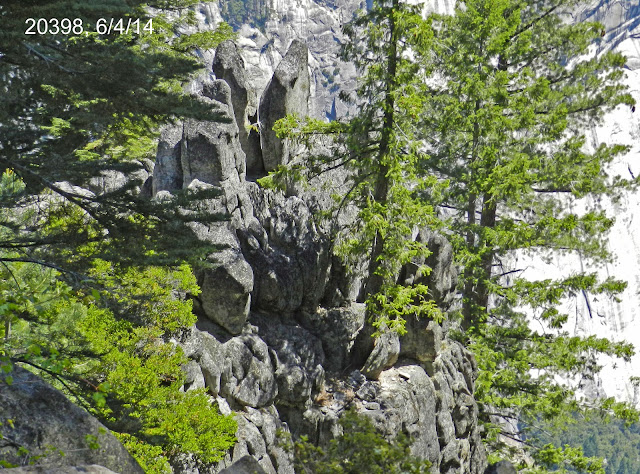
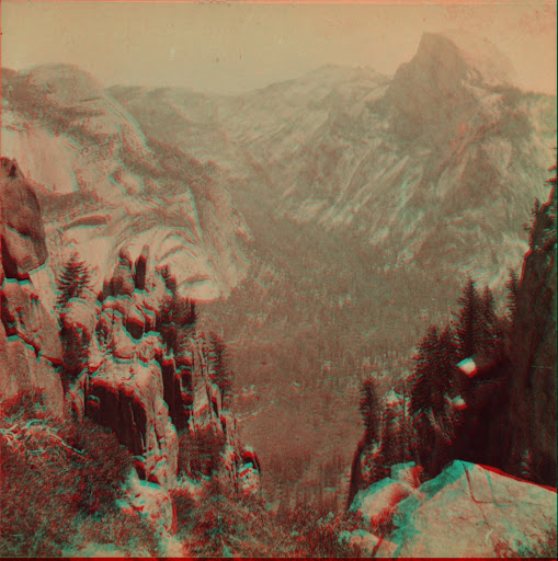
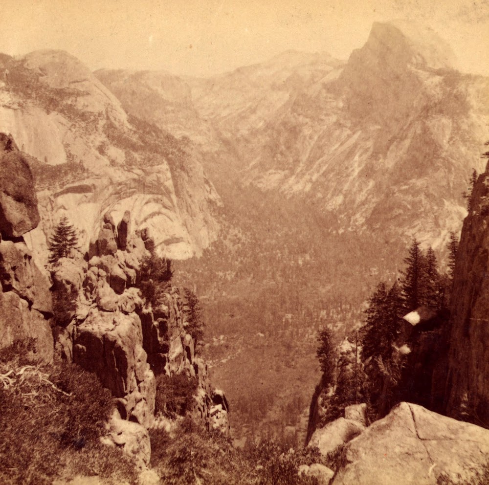
Also did you spot that unique balancing rock formation that's on the far left-hand side of Fiske's and Watkin's photo?
George Fiske's photo of Moran Point:

November 30, 2012 08:27PM | Moderator Registered: 14 years ago Posts: 7,421 |
|
Re: Moran Point December 01, 2012 03:41PM | Registered: 14 years ago Posts: 755 |
Quote
plawrence
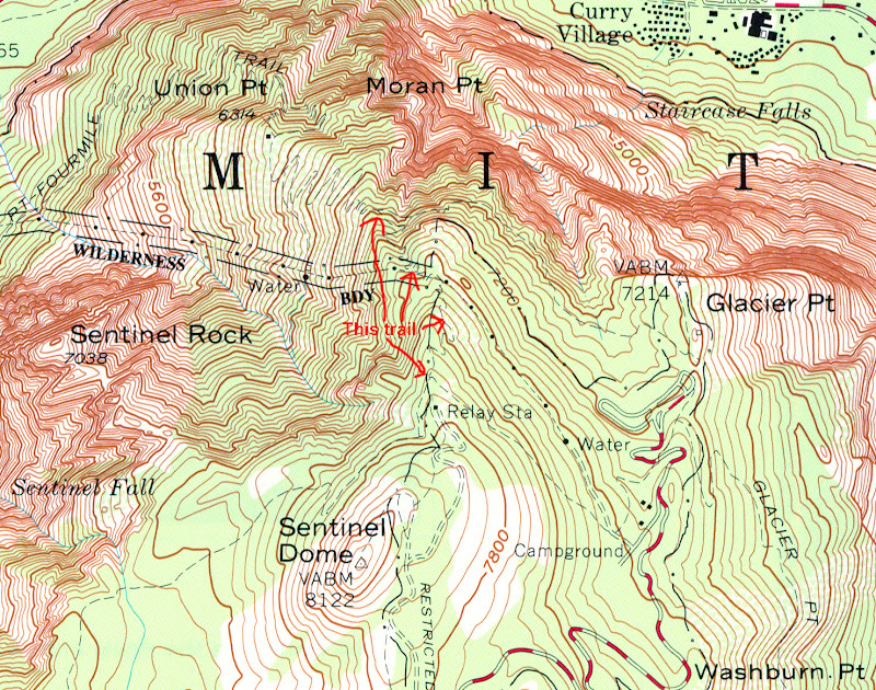
I was actually referring to this old trail that connects the Four Mile Trail with Sentinel Dome as it was still shown on this 1970 USGS topo map of Yosemite Valley:

December 04, 2012 05:38PM | Registered: 11 years ago Posts: 299 |
Quote
plawrence
I was actually referring to this old trail that connects the Four Mile Trail with Sentinel Dome as it was still shown on this 1970 USGS topo map of Yosemite Valley:


